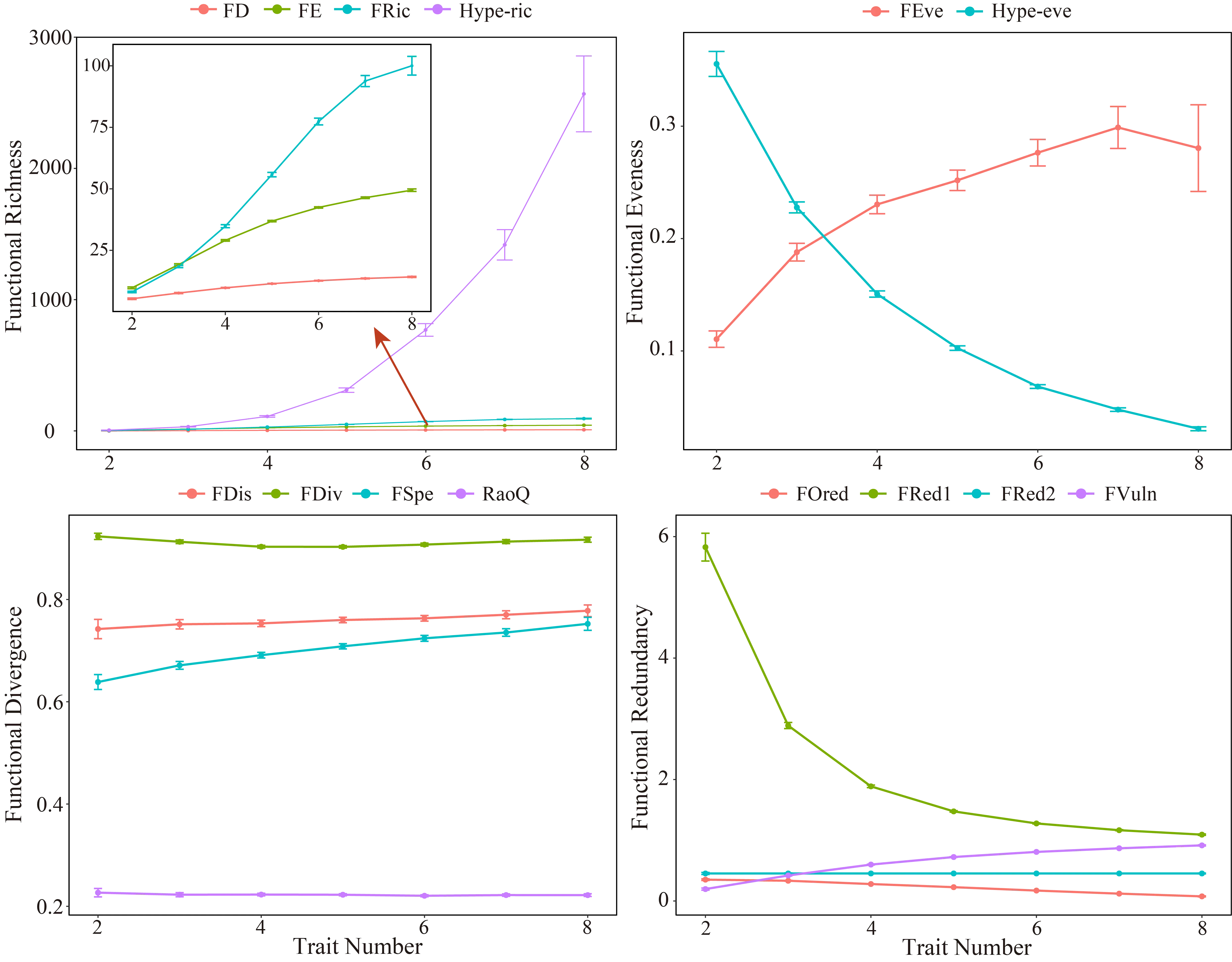
Functional diversity estimates increasingly inform ecological research, yet how methodological choices such as trait number and coding affect common metrics remains poorly quantified. Here, we systematically evaluate the effects of trait number and coding strategy on functional diversity metrics using benthic macroinvertebrate traits. Across 14 functional diversity indices representing functional richness, evenness, dispersion, and redundancy, we showed that metric responses to trait number are highly facet-dependent. Functional richness and evenness indices were particularly sensitive to trait number, whereas dispersion and redundancy metrics were comparatively stable. Estimation uncertainty was minimized at intermediate trait number, indicating a potential balance between functional space resolution and statistical robustness. Despite broad consistency between binary and fuzzy coding approaches for several metrics, redundancy metrics showed substantial divergence between coding schemes. These results demonstrate that hidden methodological decisions can substantially influence functional diversity indices. Our study provides a quantitative framework for evaluating metric robustness and reveals that widely used indices differ fundamentally in their response to dimensionality—a mathematical behaviour that must be understood before ecological interpretation. We recommend reporting trait number alongside functional diversity values and exercising caution when comparing communities assessed with different trait sets, particularly for richness and evenness metrics.
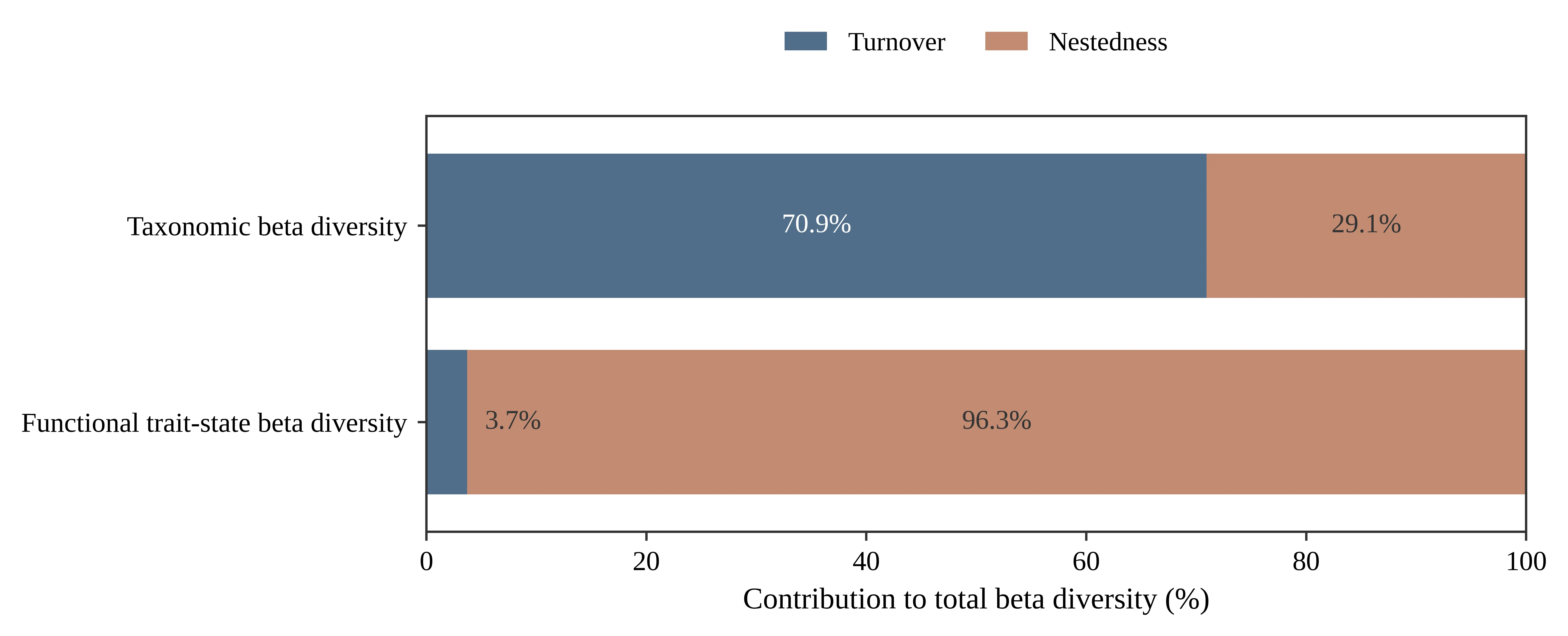
Fine-scale habitat heterogeneity can generate marked short-distance variation in alpine-stream benthic macroinvertebrate assemblages, yet routine surveys often characterize a site using five Surber-net replicates collected within an approximately 100 m reach. We analyzed 99 quantitative samples collected at 10 m intervals along a 1 km reach of Qingbixi Stream on Cangshan Mountain, Dali, Yunnan, China, to relate taxonomic and functional diversity patterns to within-site sampling design. The samples contained 69 taxa and 15,034 individuals. Across 20 consecutive 50 m sections, turnover accounted for 70.9% of mean total pairwise taxonomic beta diversity, whereas nestedness accounted for 96.3% of mean total functional trait-state beta diversity. Taxonomic dissimilarity increased weakly but significantly with longitudinal distance. In ten simulated nominal 100 m sampling units, five spatial replicates detected an average of 82.9% of the locally observed taxon pool; completeness increased to 87.4% with six replicates and 94.6% with eight. These results support five replicates as a practical baseline for routine community characterization, while more intensive or microhabitat-stratified sampling is preferable when near-complete taxon detection or fine-scale beta-diversity assessment is required.
Groundwater represents one of the most important freshwater resources in Nigeria and serves as a major source of water for domestic, agricultural, and industrial activities. This scoping review synthesizes existing knowledge on groundwater systems, aquifer characterization, hydrogeophysical investigations, groundwater quality, and sustainability challenges across different hydrogeological environments in Nigeria. The review adopted the PRISMA-ScR framework and analyzed peer-reviewed studies published between 2000 and 2026, retrieved from Scopus, Web of Science, Google Scholar, ScienceDirect, and SpringerLink databases. The findings revealed substantial hydrogeological variability associated with the Basement Complex terrains, sedimentary basins, Coastal Plain Sands, and alluvial aquifer systems. Vertical Electrical Sounding (VES), Electrical Resistivity Tomography (ERT), hydrochemical analysis, GIS integration, and remote sensing emerged as the dominant groundwater investigation techniques. The review further identified increasing groundwater quality deterioration resulting from salinity intrusion, industrial pollution, oil spill contamination, excessive groundwater abstraction, and climate variability. Coastal aquifers within the Niger Delta, Lagos, and Akwa Ibom regions were found to be particularly vulnerable to seawater intrusion and hydrocarbon contamination. Despite increasing groundwater studies, major gaps remain in long-term monitoring, integrated hydrogeophysical investigations, and national groundwater database development. The study emphasizes the need for integrated groundwater management, sustainable policy frameworks, climate-resilient groundwater assessment approaches, and interdisciplinary research strategies to support long-term groundwater sustainability and water security in Nigeria.
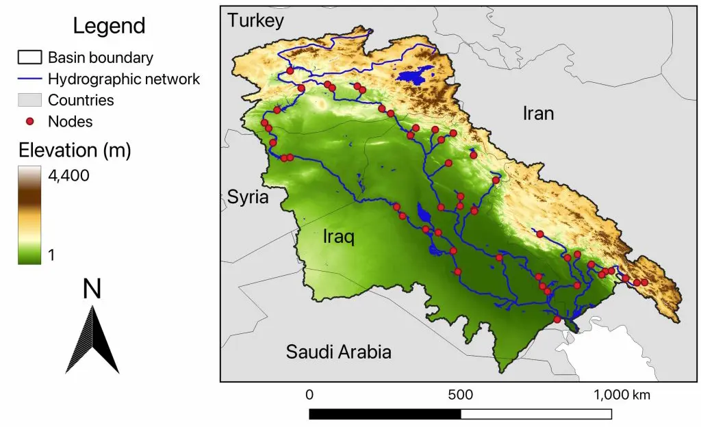
In late May 2026, the Euphrates River experienced a significant flooding event, with water levels rising approximately four meters in some locations. Water flows increased from normal levels of approximately 300–500 m3/s to peak releases of 1800 m3/s. The flood resulted from a confluence of extreme meteorological conditions—record rainfall across Syria and Türkiye, combined with rapid snowmelt in the Turkish highlands—and dam operations, including the first opening of the Atatürk Dam spillway gates in seven years and the first opening of the Euphrates Dam floodgates in approximately four decades. While the 2026 event was moderate by historical standards (smaller than the 1969 flood and the 1988 flood of 2760 m3/s at Husaybah), the opening of the Euphrates Dam floodgates after approximately 40 years was unprecedented in the post-dam era. This paper synthesizes available data on the event’s causes, impacts, and implications for transboundary water management, drawing on official statements from Syrian, Turkish, and Iraqi authorities as well as hydrological literature and multiple language sources. The analysis places the 2026 event within the broader context of the Euphrates River’s hydrological history, examining both historical flooding events and the multi-decadal drought patterns that have characterized the basin over the past century. The paper also identifies institutional instability in Syria’s water sector following the 2024 political transition as a potential contributing factor deserving investigation, while acknowledging that direct causal evidence remains limited. Based on these findings, the paper recommends improved transboundary coordination, infrastructure upgrades, and—subject to further investigation of the institutional hypothesis—reconstitution of Syria’s water management technical capacity to ensure future hydrological resilience.
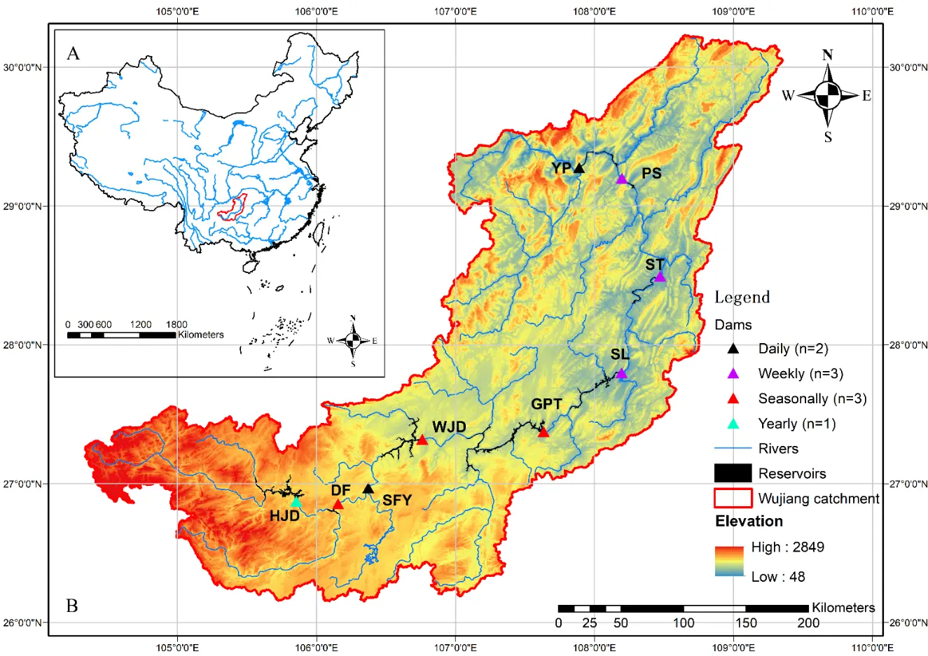
(I) Large dams alter flow regimes and water-level fluctuations, reshaping riparian disturbance regimes and shoreline habitat conditions, with important implications for vegetation recovery, biodiversity maintenance, non-native species establishment, and reservoir shoreline management. However, how these effects vary among flow regulation types and water-level fluctuation (WLF) zonation remains insufficiently understood in cascade reservoir systems. We asked: (1) how species richness, alpha diversity, beta diversity, and the proportion of non-native species vary among flow regulation types and WLF zonation; (2) which plant species indicate different regulation types and WLF zonation; and (3) which biotic or abiotic factors best explain variation in riparian species composition. (II) WLF zonation of nine cascade reservoirs along the Wujiang River, central China. (III) We surveyed 573 quadrats across 72 sites in inundation, transitional, and unflooded zones of reservoirs with daily, weekly, seasonal, or yearly regulation. Vegetation composition and local environmental variables were recorded. ANCOVA was used to test differences in vegetation diversity and non-native species proportion among regulation types and WLF zonation. Redundancy analysis and variation partitioning were used to assess the relative effects of dam properties, hydrological alteration, and local environmental factors on species composition. (IV) Riparian vegetation differed clearly among regulation types and WLF zonation. Seasonally regulated reservoirs supported the highest herbaceous species richness in the inundation zone, followed by daily and weekly reservoirs, and then the yearly regulated reservoir. Daily reservoirs had the highest beta diversity, whereas the yearly reservoir had the lowest. Annual species were mainly associated with yearly regulated shorelines, while perennial species dominated daily and weekly reservoirs. Non-native species also varied among regulation types and WLF zonation, with Alternanthera philoxeroides and Erigeron canadensis associated with weekly and seasonally reservoirs, respectively. Indicator species differed among regulation types and WLF zonation, suggesting distinct vegetation assemblages under contrasting regulation regimes. Dam properties were the strongest predictors of riparian species composition, while hydrological alteration and local environmental conditions also contributed. (V) Riparian vegetation composition in cascade reservoirs reflects the cumulative effects of contrasting long-term flow regulation regimes, WLF zonation, and associated environmental filtering. Regulation type was linked to differences in plant diversity, annual-perennial dominance, non-native species occurrence, and community composition. These findings highlight the need to consider long-term hydrological regulation and invasion risk when managing and restoring reservoir WLF zonation.
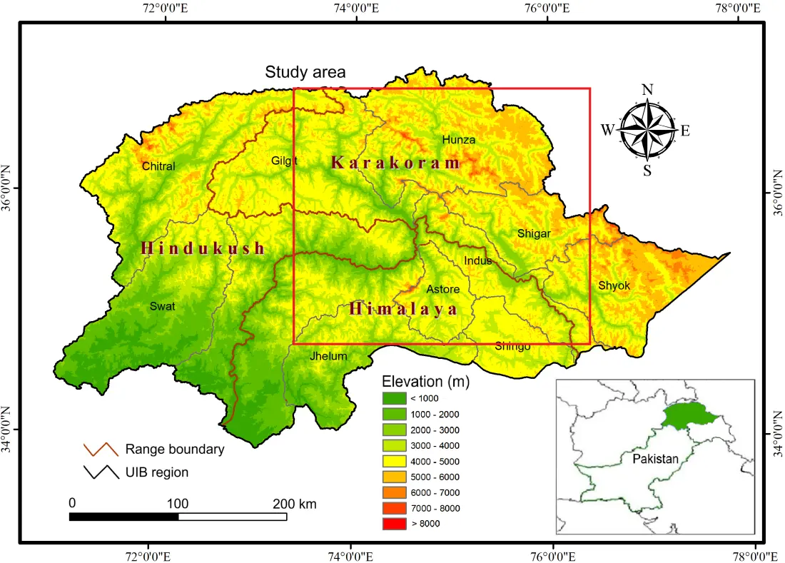
Lakes provide a wide range of ecological, cultural, and economic benefits and prime opportunities for recreation, tourism, and livelihoods in the Upper Indus Basin (UIB). In the wake of growing anthropogenic actions and climate change impacts, an appraisal of the lake water quality is essential to determine the health of the ecosystem and assist resource conservation initiatives in the region. An attempt has been made to establish a preliminary physicochemical baseline for eight high-altitude lakes in the UIB, Pakistan, to characterize their spatial hydrochemical variability and identify potential water quality concerns in the region. At the time of sampling, the lakes exhibited a slightly alkaline condition with pH ranging between 7.7 and 8.2 (mean 8.0). The lower alkalinity detected in the lakes, like Sheosar (42 mg/L), may indicate limited buffering capacity and more sensitivity to nutrient pulses or potential acidification. Nitrate-N concentration was low in most lakes, with many below detection limits. The Gibbs diagram indicated seven samples in the rock dominance zone, i.e., chemical weathering of rocks as the major factor contributing ions to the lake water, while in one sample, i.e., Borith Lake, evaporation-crystallization was the main source of dissolved chemical ingredients. The Spearman correlation analysis indicated a higher positive relationship (r > 0.9) between Ca and Mg, likely due to carbonate rock weathering. The observed variations in the water quality parameters may have significant effects on both the ecosystem and human health, necessitating further research and future attention. In-depth research on glacio-hydrological dynamics and limnology can support sustainable management and conservation of the freshwater ecosystems in the region.
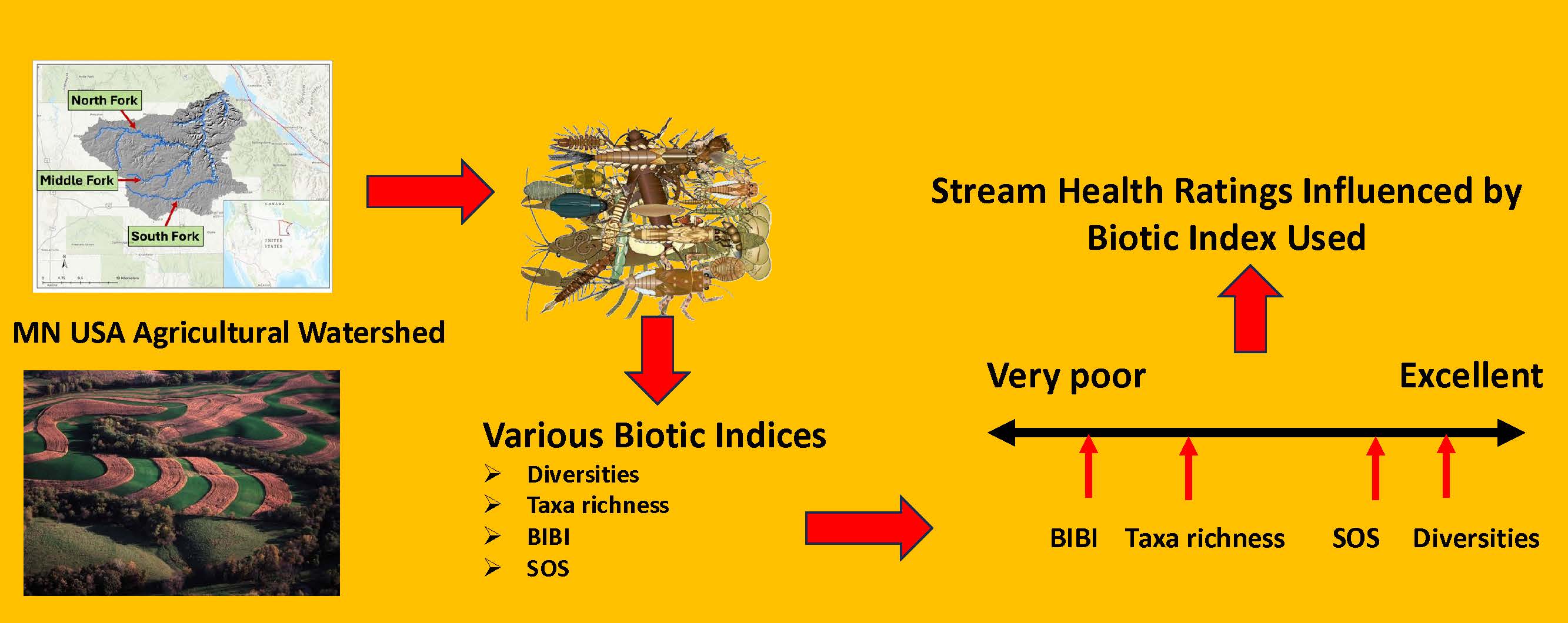
Various biotic indices have been used to assess the condition of aquatic macroinvertebrate communities in agricultural watersheds. We collected 171 samples of benthic macroinvertebrates from 57 stream sites on three forks of an agricultural watershed in southeastern Minnesota, USA, and compared the abilities of various diversity, taxa richness, and multi-metric indices to evaluate invertebrate community health and/or level of impairment. Total invertebrate abundance (sample count), total taxa richness, Ephemeroptera-Plecoptera-Trichoptera (EPT) taxa richness, Simpson diversity, Shannon diversity, a regional benthic index of biotic integrity (BIBI), and the national Izaak Walton League’s Save Our Streams (SOS) rating score were all significantly correlated with one another. Total taxa richness, BIBI score, and SOS score displayed nearly identical influences within a principal components analysis (PCA) ordination. Only total abundance and the two diversities differed significantly among stream forks. When the distributions of sites among rating categories (poor or very poor to excellent) were compared for the various indices, nearly all indices rated community health differently from one another. In order from highest ratings to lowest ratings, the indices were: Simpson diversity, Shannon diversity, SOS score, total taxa richness, EPT taxa richness, and BIBI score. Taxa richness measures and the multi-metric BIBI appeared to rate stream health more realistically (i.e., mostly fair or poor site ratings with relatively few good to excellent) than either of the diversity indices or the SOS score (many good, very good, and excellent site ratings), suggesting that the choice of biotic index can significantly influence evaluations of stream communities in an agricultural watershed.
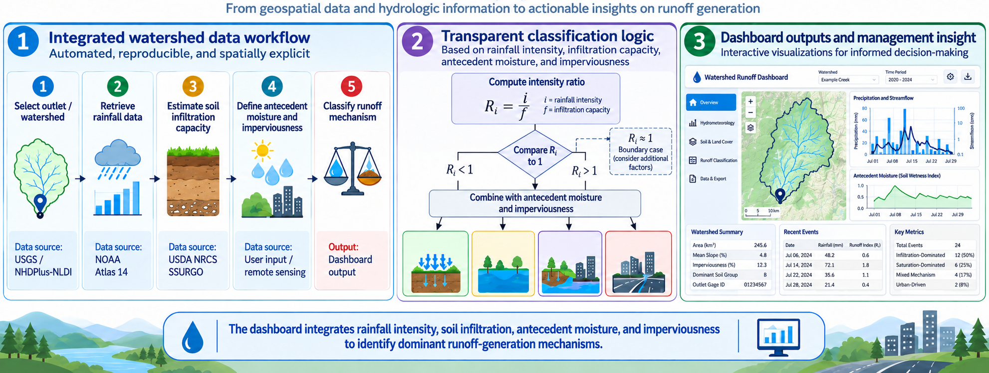
Identifying the runoff generation mechanism is helpful for decision-making and for selecting the most appropriate model to simulate runoff processes. Watershed managers require practical tools to understand how stormwater responds to changes in land use, urbanization, and climate variability. Many hydrologic models estimate runoff volume, peak flow, or flood frequency, but few tools clearly identify whether runoff is primarily driven by infiltration excess, saturation excess, or a combination of processes. This manuscript presents the development and conceptual application of an automated watershed management dashboard that integrates watershed delineation, rainfall-frequency data, soil infiltration capacity, antecedent moisture, and imperviousness in one interactive workflow. The dashboard delineates the watershed for a selected USGS streamgage, retrieves rainfall data for different storm durations and return periods, calculates rainfall intensity, estimates soil infiltration capacity, and evaluates antecedent moisture conditions. The classification framework compares rainfall intensity with soil infiltration capacity while also considering soil saturation and urban imperviousness. Based on these conditions, the dashboard classifies the likely runoff response as infiltration-excess runoff, saturation-excess runoff, or mixed runoff. Results are presented through an interactive map, tables, color-coded classifications, charts, and downloadable outputs. The dashboard is intended as a screening and decision-support tool that can support engineers, watershed managers, planners, and researchers in flood mitigation, green infrastructure planning, and ecological protection.
Considering the 518 km middle stretch of the Ganga River, we conducted in-situ and controlled incubation studies from 2021 to 2024 to investigate carbon degradation-driven biogeochemical changes in the river constrained by climate warming and atmospheric deposition of nutrients. High concentrations of labile (415.70 µg·C·g−1) and recalcitrant (231.30 µg·C·g−1) carbon fractions coupled with extracellular enzyme activities and CO2 emissions (up to 270 mg·m−2·h−1) indicated microbial degradation and, consequently, dissolved oxygen depletion (≤2 mg·L−1) at polluted sites. The combined influence of atmospheric nutrient loading, hypoxia-driven sediment-P release, and denitrification associated nitrogen loss, shifts N:P ratios of river water and sediments. Warming altered the redox conditions at sediment-water interface, enhancing microbial extracellular enzyme activities and CO2 emission (up to 24% at +2 °C). However, it caused a decline in microbial apparent carbon use efficiency. The study shows that the multi-stressors synergy and associated feedbacks progressively destabilizes riverine stoichiometric balance with a likely switch over to N or P limitation and ecological functioning. Our study highlights that the watershed-scale nutrient loading and climate-sensitive biogeochemical transformations jointly regulate oxygen-dependent nutrient cycling in large rivers, emphasizing the need for integrated river-watershed management under a changing climate scenario.