
Groundwater Systems, Aquifer Characterization, and Sustainability Challenges in Nigeria: A Scoping Review of Hydrogeological and Geophysical Investigations (2000–2026)
Groundwater Systems, Aquifer Characterization, and Sustainability Challenges in Nigeria: A Scoping Review of Hydrogeological and Geophysical Investigations (2000–2026)

Received: 28 May 2026 Revised: 15 June 2026 Accepted: 22 June 2026 Published: 04 August 2026

© 2026 The authors. This is an open access article under the Creative Commons Attribution 4.0 International License (https://creativecommons.org/licenses/by/4.0/).
1. Introduction
Groundwater is one of the most vital natural freshwater resources on earth and is a strategic source of natural freshwater resources for domestic, agricultural, industrial and environmental sustainability. Groundwater supplies more than two billion people with potable water globally, particularly in areas with scant and highly seasonal surface water supplies [1,2]. Groundwater systems are less dependent on short-term climatic variations as they have a natural storage capacity that enables them to sustain water supply during dry seasons/drought periods [3]. This buffering property has led to groundwater being a key element of global water security and climate resilience approaches.
Groundwater is the main source of drinking water in many developing countries primarily because it is relatively more accessible, less infrastructure-intensive, and generally available with better microbiological quality when compared to untreated surface water [4,5]. Global groundwater dependence has increased greatly due to population growth, urbanization, and industrial expansion. Agriculture is the biggest user of groundwater globally, which is used in food production systems for a significant portion of irrigation. Groundwater is also critical for industrial processes, cooling systems, and energy generation applications [6,7]. Groundwater has thus emerged as an important issue in the current governance agenda and resource planning.
In addition to its hydrologic functions, groundwater is also a significant ecological resource for sustaining wetlands, rivers, springs, and land-based ecosystems. Groundwater/surface water interactions are critical, as many rivers will dry up during dry seasons unless groundwater is discharging to them [8]. In many parts of the world, however, groundwater levels have declined, and water quality has degraded as a result of enhanced anthropogenic influences, climate change, and over-abstraction. However, saline water intrusion, heavy metal pollution, nitrate pollution, and aquifer overexploitation are emerging problems, especially in coastal and urbanized areas [9].
Groundwater is increasingly recognized as important in the context of the United Nations Sustainable Development Goals (SDGs), specifically SDG 6: Ensure access to water and sanitation for all. Additionally, groundwater sustainability is directly connected to SDG 2 (Zero Hunger) and SDG 3 (Good Health and Well-being), SDG 11 (Sustainable Cities and Communities), and SDG 13 (Climate Action) [10,11]. Groundwater development in a sustainable way is thus crucial in the context of poverty eradication, food security, climate adaptation, and socioeconomic development. Groundwater is increasingly considered as a strategic resource that can improve resilience to environmental and climatic changes in the context of climate variability and growing water stress [12].
Groundwater is one of the most dependable and most used sources of freshwater in Nigeria for domestic, agricultural, and industrial use. In the last several decades, the use of groundwater has grown significantly because of the limited provision of public water supply infrastructure and the rise in population growth [13]. Boreholes, hand dug wells, and springs are the primary sources of water for both urban and rural communities to satisfy their day to day water requirements. Groundwater is also the major source of potable water in many parts of the country, as surface water is either absent, seasonally available but unreliable, or contaminated [14,15,16].
The rural areas of Nigeria are especially reliant on shallow wells and boreholes for their domestic needs, including drinking, cooking, bathing, and sanitation. However, in urban areas, the inability of the urban water supply system to provide for a growing population has led to the widespread development of private boreholes [17,18]. As a result, aquifer exploitation has become more spread out and largely unregulated in many cities. Independent borehole systems are commonly used in commercial buildings, residential properties, hospitals, educational institutions, and industries to provide a reliable source of water.
Groundwater is also relevant to agricultural activities, particularly in arid and semi-arid areas of northern Nigeria, where rainfall variability and the long dry seasons impact rain-fed farming systems [19]. Groundwater abstraction is used for crop production in some regions in dry seasons, and this is a requirement for irrigation schemes. Groundwater resources are also critical in sustaining industrial processes like food processing, beverage production, manufacturing, petroleum refining, and mining [20].
The use of boreholes and hand dug wells is widespread and is an indication of the strategic value of groundwater and the lack of water infrastructure in Nigeria. As urbanisation and population growth have increased in the country, borehole drilling has grown at an unprecedented rate [21]. Groundwater quality is becoming degraded, and aquifer stress is occurring in some areas due to the indiscriminate abstraction of groundwater, poor construction, and monitoring practices. Groundwater pollution from waste disposal, septic systems, industrial effluents, and hydrocarbons is a significant environmental issue in many rural/urban and industrial communities [15].
However, groundwater management in Nigeria has been limited by the scarcity of hydrogeological data, poor regulatory systems, and a lack of long-term monitoring systems, despite having become more reliant on groundwater resources. Integrated hydrogeological studies, good groundwater governance, and the use of current groundwater assessment tools that can support informed water resource planning and environmental sustainability are therefore essential for sustainable groundwater development [22].
Nigeria has many different geological formations and hydrogeological environments, which have a significant influence on groundwater occurrence, storage, movement, and quality [23]. The country can be broadly divided into two major geological provinces: the Precambrian Basement Complex and the sedimentary basins. Groundwater properties, productivity, recharge processes, and hydrochemical variability vary across different areas, mainly controlled by these geological units [24].
The Basement Complex terrain forms a major part of south west, north central and north west of Nigeria, and is made up mainly of crystalline igneous and metamorphic rocks like granites, gneisses, schist, quartzites, and migmatites [25]. The Basement Complex has negligible primary porosity, and groundwater is found mostly in the weathered regoliths and fractures. Groundwater productivity, therefore, in the Basement terrains is dependent on the extent of weathering, fracture density, and structural discontinuities [26]. The aquifers are often shallow and discontinuous in these areas, with borehole yields varying.
Sedimentary basins in Nigeria on the whole have higher groundwater potential because of porous and permeable sedimentary rocks. The major sedimentary basins are Chad Basin, Sokoto Basin, Benue Trough, Dahomey Basin, Anambra Basin, Bida Basin, and Niger Delta Basin. Sandstone, limestone, shale, and unconsolidated sediments that can hold large volumes of groundwater are found in these basins [27].
The Niger Delta Basin is one of the most productive hydrogeological provinces in Nigeria because of the presence of highly permeable Coastal Plain Sands and alluvial deposits [28]. The Benin Formation is the major aquifer of the Niger Delta region and is composed primarily of unconsolidated sands, gravels, silts, and clay intercalations with high groundwater storage capacity [29]. The groundwater in the Niger Delta is overall under unconfined to semi-confined conditions with provision of water supply for domestic, industrial, and agricultural purposes [30]. But, saline water intrusion and hydrocarbon contaminations linked to oil exploration activities are the growing threats for coastal areas in the Niger Delta [29].
The Chad Basin of north-eastern Nigeria contains thick sequences of sandstones, clays, and unconsolidated sediments containing abundant confined and unconfined aquifers. The groundwater resources in the Chad Basin are especially vital for human use in both irrigation and domestic supply in the semi-arid climates [31]. Likewise, in Gwandu and Illo formations in the Sokoto Basin, northwestern Nigeria, productive sedimentary aquifers have been found [32].
Sedimentary sequences in the Benue Trough include sandstone, shale, limestone, and volcanic intrusions. The Benue Trough has structurally complex conditions with lithological heterogeneities that create a spatial variability in its hydrogeological conditions [33]. Coastal Plain Sands are found throughout the southern part of Nigeria and have significant groundwater potential with high productivity, but have the potential of being contaminated and saline intruded because of their proximity to the Atlantic Ocean [33].
Climatic conditions, lithological, structural controls, recharge processes, and anthropogenic activities have all contributed to the variability of the hydrogeology of Nigeria. Groundwater availability and quality in various regions of the country vary due to variations in rainfall distribution, topography, permeability, and thickness of the aquifer [34].
The geologic structures and the major aquifer systems of Nigeria are shown in Figure 1, which indicates the influence of the Basement Complex terrains, sedimentary basins, and Coastal Plain Sands on the occurrence and productivity of groundwater. Figure 1 shows that sedimentary formations normally have high groundwater potential, whereas weathered and fractured Basement terrains largely depend on weathered and fractured zones for groundwater storage.
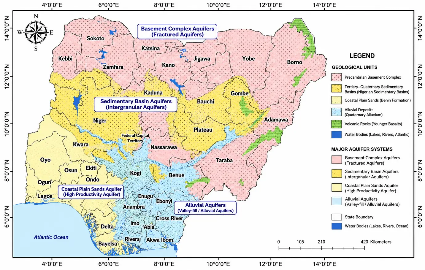
Figure 1. Geological Map and Major Aquifer Systems of Nigeria showing the spatial distribution of principal hydrogeological units (Projection: UTM Zone 32N; Datum: WGS 1984).
Several environmental and anthropogenic factors pose threats to the groundwater resources and erode their quality, availability, and sustainability in Nigeria [35]. Groundwater pollution due to hasty urbanization, industrialization, agriculture, and poor waste management is one of the biggest challenges. Groundwater systems have been found to contain several types of contaminants, including heavy metals, hydrocarbons, nitrates, pathogens, and industrial chemicals in various parts of the country [36].
Another major challenge is salinity intrusion, especially in the coastal areas like the Niger Delta, Lagos, and other parts of southern Nigeria. Irrigated groundwater extraction in coastal aquifers can lead to a reduction in the hydraulic gradient between fresh and saline groundwater, which can cause saline groundwater to enter fresh groundwater systems [37]. Climate change-induced sea-level rise further adds to the vulnerability of coastal groundwater systems [11].
Population growth and urban water demand have also led to over abstraction of groundwater resources, which has led to falling levels of groundwater in many cities. Aquifer depletion and groundwater stress can be attributed to poorly managed groundwater governance and unregulated borehole drilling [18]. Furthermore, oil exploration and production operations in the Niger Delta have led to contamination of the groundwater system through oil spills, pipeline leaks, and waste disposal [38].
Groundwater recharge and sustainability are also at risk due to climate variability and shifts in rainfall patterns. In semi-arid regions, prolonged droughts, irregular precipitation, and increased evapotranspiration can lead to reduced recharge rates to the aquifers and higher vulnerability of groundwater [36].
This has led to a great improvement in the techniques for investigating and characterizing the groundwater resources of Nigeria, as well as the assessment of groundwater quality. Vertical Electrical Sounding (VES) and Electrical Resistivity Tomography (ERT) are widely used electrical geophysical methods for delineating aquifer zones, estimating aquifer thickness, and locating groundwater bearing formations. The methods are especially useful in Basement Complex terrains with a structurally controlled occurrence of groundwater [39].
Borehole logging techniques can give detailed information on lithology, aquifer geometry, porosity, and groundwater occurrence. Pumping tests are frequently performed to determine hydraulic parameters of an aquifer, like transmissivity, hydraulic conductivity, and storage coefficient. Hydrochemical analyses are also crucial in the study of groundwater quality, source of contamination, and hydrogeochemical processes [40].
Geographic Information Systems (GIS) and remote sensing analysis have been integrated to improve the groundwater potential mapping, groundwater recharge estimates, lineament analysis, and groundwater vulnerability studies [41,42,43]. In addition, resistivity data are increasingly being used to generate parameters used in assessing the protective capacity of aquifers and groundwater transmissivity (Dar-Zarrouk parameters) [44].
This review aims to synthesize existing knowledge on groundwater systems, aquifer characterization approaches, and sustainability challenges in Nigeria using hydrogeological and geophysical perspectives. The review seeks to evaluate the distribution and characteristics of major aquifer systems, examine advances in groundwater investigation techniques, assess emerging groundwater sustainability challenges, and identify critical research gaps requiring future investigation.
2. Methodology
This study adopted a structured scoping review methodology to synthesize existing knowledge on groundwater systems, aquifer characterization, hydrogeophysical investigations, groundwater quality, and sustainability challenges in Nigeria. The methodological workflow consisted of six major stages: (i) formulation of review objectives and research questions; (ii) systematic literature search across multiple scientific databases; (iii) screening and selection of relevant studies using predefined inclusion and exclusion criteria; (iv) extraction of hydrogeological, hydrogeophysical, hydrochemical, and sustainability-related information; (v) thematic classification and synthesis of evidence; and (vi) identification of research gaps, emerging technologies, and future research priorities. The overall methodological framework adopted in this study is illustrated in Figure 2.
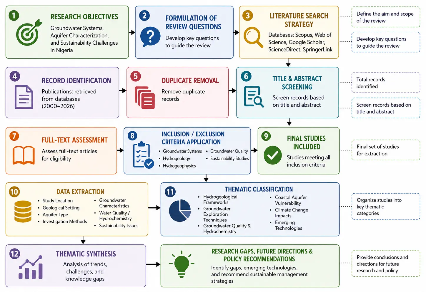
Figure 2. Schematic Methodological Framework for the Scoping Review of Groundwater Systems and Aquifer Characterization Studies in Nigeria.
2.1. Scoping Review Framework
The methodology used in this study is the scoping review method, which aims to systematically map, synthesize, and evaluate the available literature on groundwater systems, aquifer characterization, and sustainability issues in Nigeria. The scoping review approach was deemed suitable due to the multidisciplinary, geographically widespread, and methodologically diverse nature of groundwater studies in Nigeria, which include hydrogeological, hydrogeophysical, hydrochemical, environmental, and geospatial studies. In contrast to systematic reviews, which aim to address specific research questions, scoping reviews can address a wider range of questions and seek to identify research gaps and to synthesize themes across a collection of diverse studies [45].
The Preferred Reporting Items for Systematic Review and Meta-Analysis Extension for Scoping Review (PRISMA-ScR), the Arksey and O’Malley methodological framework, and the Joanna Briggs Institute (JBI) suggestions were used to guide the review framework. To enhance transparency and reproducibility in the literature screening and review process, a structured reporting guideline (PRISMA-ScR) was used throughout to identify the literature, conduct screening, assess eligibility, and finalize the inclusion of literature for analysis [46]. The Arksey and O’Malley framework has been used for its flexibility in integrating multidisciplinary evidence and its applicability to environmental and hydrogeological review-based studies [47]. The framework has five components: identification of research questions; identification of relevant studies; selection of studies; charting data; and synthesis of findings.
Additionally, the Joanna Briggs Institute (JBI) guidelines were used to enhance methodological rigor and consistency for evidence synthesis. JBI prioritizes the thorough search of the literature, the clearness of inclusions and the systematic thematic classification of evidence [48]. These frameworks, taken together, improved the trustworthiness, completeness, and repeatability of the current review.
The review was limited to studies on groundwater occurrence, groundwater systems, hydrogeological characterisation, groundwater quality, hydrogeophysical studies, groundwater sustainability problems and new technologies in groundwater assessment in Nigeria. The focus was on detecting spatial patterns, methodologies, sustainability issues, and research needs for groundwater studies conducted in various geological and hydrogeological settings in the country.
The adoption of the PRISMA-ScR, Arksey and O’Malley, and Joanna Briggs Institute frameworks enhanced methodological transparency, reproducibility, and consistency throughout the review process.
2.2. Literature Search Strategy
A thorough literature search strategy was used to obtain relevant peer reviewed publications on groundwater systems and aquifer characterization in Nigeria. A systematic search of multiple international scientific databases was undertaken to provide good coverage of hydrogeological, geophysical, environmental, and water resources literature. Selected databases included Scopus, Web of Science, Google Scholar, ScienceDirect, and SpringerLink. These databases were selected because of their extensive coverage of hydrogeological, hydrogeophysical, environmental, and water-resources literature relevant to groundwater investigations. These databases were chosen because they cover a significant percentage of groundwater related studies and have wide multidisciplinary coverage relevant to hydrogeological and hydrogeophysical studies.
The literature search included publications from 2000 to 2026 to reflect current progress and advancement in groundwater exploration, aquifer characterization, groundwater quality study, and groundwater sustainability in Nigeria. This time frame was chosen because of the many developments in geophysical methods, GIS applications, hydrochemical analysis, and groundwater sustainability studies that have taken place over the last twenty years.
Boolean operators were used in the search process, including “AND”, “OR”, and “NOT” to be used to tighten search combinations and help retrieve the most accurate information. Various combinations of keywords were used to access studies on groundwater systems, aquifer investigations, hydrogeophysics, groundwater quality, and sustainability issues in Nigeria. Reference lists from selected articles were used to conduct additional manual searches for relevant articles that were not found in the initial database searches.
The literature search was carried out in a multi-step process with the aim of avoiding the omission of relevant literature. Articles were screened for inclusion based on title and abstract, then by full-text review. Duplicate records retrieved from various databases were identified and eliminated prior to the screening process. A search strategy was developed to be as comprehensive as possible in capturing studies specifically related to the goals of this review.
2.3. Search Keywords
A range of search terms and their combinations were used in the literature search. The keywords were developed to include studies on groundwater occurrence, aquifer systems, hydrogeological characterization, groundwater quality, hydrogeophysics, and groundwater sustainability in Nigeria. The keywords used were: Groundwater Nigeria; Aquifer characterization Nigeria; Hydrogeophysics Nigeria; Groundwater quality Nigeria; Coastal aquifers Nigeria; Electrical resistivity groundwater Nigeria; Groundwater sustainability Nigeria; Hydrogeological investigations Nigeria.
Other search terms used were: “VES groundwater Nigeria”, “ERT groundwater studies Nigeria”, “GIS groundwater mapping Nigeria”, “Groundwater contamination Nigeria”, “Salinity intrusion Nigeria”, and “Groundwater recharge Nigeria”. Boolean operators were added to refine search results. In this regard, database searches were conducted using combinations of search terms, e.g., “Groundwater” AND “Nigeria” AND “Aquifer characterization”, “Hydrogeophysics” OR “Geophysical investigations” AND “Nigeria”, and “Groundwater quality” AND “Coastal aquifers” AND “Nigeria”.
To ensure multidisciplinary research, including hydrogeology, hydrochemistry, environmental geology, geophysics, GIS application, and groundwater sustainability assessments were included, the search was deliberately wide with broad keywords. The entire search process was further carried out in an iterative manner with the aim of improving the retrieval efficiency and minimizing the number of irrelevant results by modifying and refining the keywords. Representative search syntaxes used in the major databases are presented in Table 1.
Table 1. Representative Search Syntax Used in Different Databases.
|
Database |
Search Syntax |
|---|---|
|
Scopus |
TITLE-ABS-KEY (“groundwater” AND Nigeria AND (“aquifer characterization” OR hydrogeophysics OR “groundwater quality” OR sustainability)) |
|
Web of Science |
TS = (“groundwater” AND Nigeria AND (“aquifer characterization” OR hydrogeophysics OR “groundwater quality” OR sustainability)) |
|
Google Scholar |
“Groundwater Nigeria” OR “Aquifer characterization Nigeria” OR “Hydrogeophysics Nigeria” OR “Groundwater quality Nigeria” |
|
ScienceDirect |
(“groundwater” AND Nigeria) AND (“aquifer characterization” OR hydrogeophysics OR “groundwater sustainability”) |
|
SpringerLink |
(“groundwater” AND Nigeria AND (“hydrogeology” OR hydrogeophysics OR “groundwater quality”)) |
2.4. Inclusion Criteria
To avoid inconsistencies and irrelevancies in the selection of the studies made available for the review, specific inclusion criteria were set up. Only peer-reviewed journal articles specifically related to groundwater systems, groundwater characterization, hydrogeological studies, groundwater quality evaluation, hydrogeophysics, and groundwater sustainability in Nigeria were included. Groundwater exploration was also conducted using geophysical methods such as VES, ERT, borehole logging, pumping tests, GIS applications, and hydrochemical analysis [49].
The studies included in this review had to be in English, contain adequate methodological and analytical detail for assessment of groundwater, and be eligible for the assessment. Only those studies that were published in English, provided adequate methodological and analytical detail for assessing groundwater, and that were eligible for groundwater assessment were included in this review. Sedimentary and Basement Complex hydrogeological contexts were studied in Nigeria. In addition, studies relevant to groundwater sustainability issues were added, such as those on groundwater contamination, salinity intrusion, groundwater vulnerability, assessment of groundwater recharge, and climate-related issues affecting groundwater [50].
Studies using hydrogeological and geophysical methods to assess groundwater, as well as those related to groundwater resource management and sustainability perspectives, were also considered in the inclusion process. The studies selected gave a good coverage of the groundwater systems and related environmental issues in Nigeria.
2.5. Exclusion Criteria
Studies that did not meet the inclusion criteria were excluded from the review. Duplicate publications retrieved from multiple databases were identified and removed during the screening stage [46,48]. Conference abstracts, editorials, unpublished reports, dissertations without accessible full texts, and non-peer-reviewed materials were excluded to ensure the scientific reliability and quality of the reviewed literature [47,48].
Studies unrelated to groundwater systems or those focusing exclusively on surface water resources without groundwater relevance were also excluded. Articles lacking sufficient methodological details, incomplete datasets, or inadequate analytical descriptions were omitted from the final synthesis [46]. Additionally, studies conducted outside Nigeria or studies with limited relevance to hydrogeological and groundwater sustainability themes were excluded from the review process.
The exclusion criteria were applied systematically throughout the screening and eligibility assessment stages to improve the consistency and credibility of the final dataset used for thematic synthesis [46,48].
2.6. Study Selection and Screening
The study selection and screening process followed the PRISMA-ScR framework to ensure transparency and reproducibility (Figure 3). The initial database searches yielded a large number of potentially relevant publications. These records were exported into a reference management system where duplicate articles were identified and removed prior to screening.
The first stage of screening involved evaluation of article titles and abstracts to determine relevance to groundwater systems, aquifer characterization, hydrogeological investigations, and groundwater sustainability in Nigeria. Studies considered potentially eligible during this phase proceeded to full-text assessment. Full-text screening was subsequently conducted to confirm compliance with the established inclusion and exclusion criteria.
The eligibility assessment involved careful evaluation of the study objectives, methodologies, geographic focus, analytical approaches, and thematic relevance to the review objectives. Studies meeting all eligibility requirements were included in the final synthesis and thematic categorization. The final included studies represented a broad range of hydrogeological, hydrogeophysical, hydrochemical, and environmental groundwater investigations conducted across different geological terrains within Nigeria.
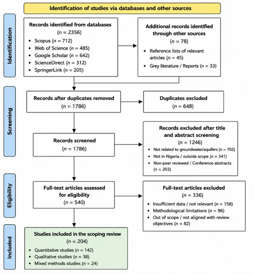
Figure 3 demonstrates the systematic and transparent procedure used in selecting groundwater-related studies included in the review, thereby improving the reliability, reproducibility, and methodological rigor of the study.
2.7. Data Extraction and Thematic Synthesis
Systematic extraction and organization of the relevant information from the selected studies were performed through thematic classification methods. The data collected were study location, geological setting, type of aquifer, methods of investigation, characteristics of groundwater, sustainability issues, and findings. Other information on groundwater quality parameters, hydrochemical facies, salinity intrusion, aquifer vulnerability, and groundwater management issues was also reported.
Hydrogeological grouping, regional categorisation, methodological classification, and sustainability issue classification were used to conduct thematic synthesis. The studies were classified in major hydrogeological provinces like Basement complex terrains, sedimentary basins, coastal aquifers, alluvial systems, etc. The regional categorisation enabled the assessment of spatial differences in groundwater investigations and sustainability issues in various regions of Nigeria.
Methodological classification was done with respect to the most important groundwater investigation techniques used in the analysed studies: geophysical, hydrochemical, GIS and remote sensing applications, and integrated hydrogeophysical. Sustainability issue classification aimed to define the major environmental and anthropogenic concerns with regard to groundwater resources, such as groundwater pollution, saline intrusion, over-abstraction, climate variability, and contamination from industry.
A thematic synthesis approach was used to evaluate the research trends, methodological developments, hydrogeological variations, and groundwater sustainability issues in Nigeria, to identify the key research gaps and future trends for groundwater assessment and management in the country.
3. Results and Thematic Synthesis
3.1. Distribution of Groundwater Studies in Nigeria
The reviewed literature revealed a substantial increase in groundwater-related studies in Nigeria over the past two decades, particularly between 2010 and 2026. The analysis of literature showed significant groundwater related research in Nigeria for the last 20 years, with a high surge in the studies between 2010 and 2026. Spatial distribution of the studies revealed that there was a high spatial variation, with most investigations concentrated in the Niger Delta region, in the southwest of Nigeria, and in parts of North Central Nigeria. This imbalance is mostly attributed to the regional variation in population density, level of industrial development, demand for groundwater, environmental sensitivity, and availability of research institutions.
The strategic economic value, the extensive oil exploration activities, and growing concerns about groundwater contamination in the Niger Delta region led to the study of the region as one of the most studied hydrogeological provinces. The quality of groundwater in Rivers [11], Bayelsa [51], Delta [52], Akwa Ibom [53] and Cross River [54] states has been the subject of numerous investigations, as well as deterioration, intrusion of salinity, contamination of hydrocarbons, and vulnerability of aquifers. Lagos State is also a well-researched area due to high urbanisation, high water extraction rates, high coastal vulnerability, and industrial pollution issues [55]. Some hydrogeophysical and hydrochemical studies have been carried out in Lagos, which reported groundwater salinisation, heavy metals contamination, and deterioration of groundwater quality due to urban expansion and coastal processes [56].
Hydrogeological interest has also been high in the region of Southwestern Nigeria, especially in the Basement Complex terrain. The major areas of groundwater studies in the states include groundwater exploration (electrical resistivity techniques, lineament mapping), aquifer vulnerability assessment, and hydrochemical characterization in Oyo [57], Osun [58], Ondo [59], Ekiti [60], Ogun [61], and portions of Kwara [62]. Groundwater development has been driven by the occurrence of a high proportion of crystalline basement rocks, and extensive use of VES and ERT has been made to identify weathered and fractured basement rock zones.
The northern part of Nigeria, especially the Chad Basin and Sokoto Basin, has also seen significant groundwater investigations due to growing water demands and semi-arid climatic conditions associated with irrigation agriculture [63]. Research within these basins often concentrated on groundwater recharge, aquifer productivity, groundwater depletion, and water stress due to climate change [63,64]. In contrast, whereas a number of the regions in the Niger Delta and southwestern Nigeria have been well studied, several other regions in the northeastern and northwestern parts of the country have been under-researched, partly because of the insecurity, research infrastructure, and limited hydrogeological monitoring system.
The trends shown in the publications reflect advancing interdisciplinary studies of groundwater that incorporate hydrogeophysics, applications of GIS, remote sensing, hydrochemistry, and environmental sustainability assessments. Previous investigations in the 2000–2010 period were mostly targeted towards the exploration and siting of boreholes for groundwater through traditional resistivity methods. More recent studies, however, are increasingly combining groundwater potential mapping using GIS, hydrochemical facies, machine learning methods, and groundwater vulnerability assessments [57,58,59,60,61,62].
There have been more groundwater studies in Nigeria, but some areas are yet to have comprehensive studies (Figure 4). The research coverage is rather poor in parts of the Middle Belt, in northeastern Nigeria, and in some parts of the inland sedimentary basins. In addition, few long-term groundwater monitoring datasets are available to inform comprehensive assessments of groundwater sustainability at the national scale. The reviewed studies showed that many investigations are localized, non-integrated, and fragmented, with limited integration across hydrogeological regions.
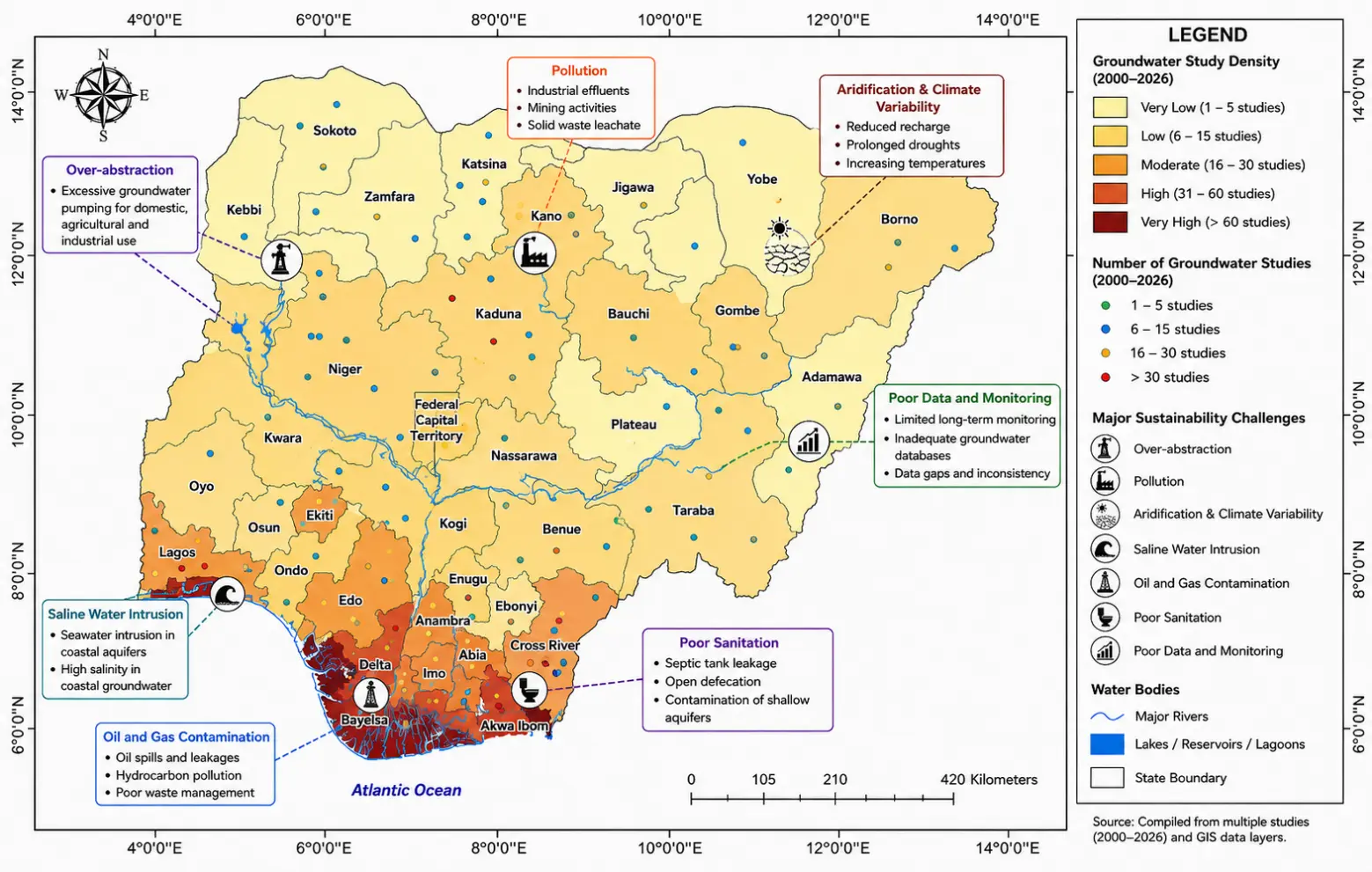
Figure 4. Spatial Distribution of Groundwater Studies and Major Sustainability Challenges in Nigeria (Projection: UTM Zone 32N; Datum: WGS 1984).
Figure 4 reveals strong regional disparities in groundwater investigations, with greater concentration in the Niger Delta, Lagos, and southwestern Nigeria due to increasing urbanization, industrialization, and groundwater contamination concerns. It also highlights key sustainability threats, including salinity intrusion, pollution, and groundwater depletion.
3.2. Hydrogeological Framework and Aquifer Systems
The reviewed studies revealed considerable hydrogeological diversity across Nigeria, resulting from variations in geological formations, climatic conditions, lithology, structural controls, and recharge mechanisms. Groundwater occurrence within Nigeria is primarily associated with two major geological provinces consisting of the Precambrian Basement Complex terrain and the sedimentary basins [65].
Basement aquifers constitute the dominant groundwater systems within southwestern, north-central, and northwestern Nigeria. These aquifers occur mainly within weathered overburden and fractured crystalline rocks due to the negligible primary porosity of granites, gneisses, schists, and migmatites [66]. Groundwater productivity within Basement terrains depends largely on weathering thickness, fracture connectivity, and structural discontinuities [67]. Several studies have reported that productive aquifers within Basement Complex regions are commonly associated with deeply weathered regoliths and fractured bedrock zones identified through resistivity investigations and borehole logging [68,69]. However, groundwater yield within these terrains is often variable and unpredictable due to lithological heterogeneity and discontinuous fracture networks.
Fractured aquifers play an important role in groundwater storage and transmission within crystalline rock environments [70]. Numerous studies have demonstrated the significance of tectonic structures such as faults, joints, fractures, and lineaments in controlling groundwater occurrence within Basement terrains [70,71]. Remote sensing and GIS-based lineament analyses have increasingly been applied to identify structurally controlled groundwater potential zones. Productive boreholes are frequently associated with high lineament density zones characterized by enhanced secondary porosity and permeability [14,72].
Sedimentary aquifers occurring within the Chad Basin, Sokoto Basin, Benue Trough, Dahomey Basin, Anambra Basin, and Niger Delta Basin generally exhibit higher groundwater potential due to the presence of porous and permeable sandstone formations [65]. The Chad Basin aquifer system contains extensive confined and unconfined aquifers capable of supporting domestic water supply and irrigation agriculture in semi-arid northeastern Nigeria [73]. Similarly, the Sokoto Basin contains productive groundwater-bearing formations associated with the Gwandu and Illo formations [74].
The Niger Delta Basin represents one of the most productive groundwater provinces in Nigeria. The Benin Formation, which forms the principal aquifer system within the Niger Delta, consists predominantly of unconsolidated sands, gravels, silts, and clay interbeds with high hydraulic conductivity and groundwater storage capacity [75]. Groundwater within this formation occurs under unconfined to semi-confined conditions and supports extensive domestic, industrial, and agricultural water supply [76]. However, coastal portions of the Niger Delta are increasingly threatened by saline intrusion, groundwater contamination, and hydrocarbon pollution associated with oil exploration activities [37].
Alluvial aquifers occurring along major river valleys and floodplains also contribute significantly to groundwater resources in Nigeria [77]. These aquifers are commonly characterized by high porosity and permeability due to unconsolidated alluvial sediments. Alluvial aquifers support dry-season irrigation and domestic water supply in several floodplain regions [78].
Lithological characteristics, aquifer thickness, recharge conditions, structural features, and climatic variability control aquifer productivity variations across Nigeria. Sedimentary aquifers generally exhibit higher transmissivity and borehole yields compared to Basement Complex aquifers [79]. Nevertheless, hydrogeophysical investigations have demonstrated that productive groundwater zones may occur within fractured crystalline environments where secondary porosity is sufficiently developed [80].
3.3. Groundwater Exploration and Characterization Techniques
The reviewed studies demonstrated extensive application of hydrogeophysical, hydrogeological, hydrochemical, and geospatial techniques for groundwater exploration and aquifer characterization in Nigeria. Electrical resistivity methods remain the most widely utilized groundwater investigation techniques due to their cost-effectiveness, efficiency, and suitability for diverse geological environments.
VES has been extensively applied for groundwater exploration, aquifer delineation, lithological characterization, and estimation of overburden thickness within both the Basement Complex and sedimentary terrains [81]. Several studies reported successful identification of weathered and fractured aquifer zones using Schlumberger and Wenner electrode configurations. VES investigations are particularly effective for determining subsurface resistivity distributions and identifying groundwater-bearing formations suitable for borehole development [82].
ERT has gained increasing popularity due to its ability to provide two-dimensional and three-dimensional imaging of subsurface resistivity structures. ERT studies conducted across coastal and Basement terrains have successfully delineated saline intrusion zones, fracture systems, lithological boundaries, and groundwater contamination plumes [83]. In coastal aquifers, ERT has proven highly effective for mapping freshwater-saltwater interfaces and identifying saline water wedges within shallow aquifer systems [84].
Borehole logging techniques have equally contributed significantly to aquifer characterization in Nigeria. Geophysical borehole logs, including resistivity, gamma ray, spontaneous potential, and caliper logs, provide detailed information on lithology, aquifer thickness, porosity, and groundwater occurrence [85]. Borehole logging is frequently integrated with pumping tests and resistivity investigations to improve aquifer characterization accuracy [86].
GIS integration and remote sensing applications have become increasingly important in groundwater studies across Nigeria. GIS-based groundwater potential mapping using thematic layers such as lineament density, drainage density, land use/land cover, slope, rainfall, lithology, and soil characteristics has significantly improved groundwater resource assessment [87]. Remote sensing data obtained from Landsat, Sentinel, SRTM DEM, and other satellite platforms are increasingly utilized for lineament extraction, recharge zone identification, and groundwater vulnerability mapping [88].
Pumping test analysis remains an important hydrogeological tool for estimating aquifer hydraulic parameters such as transmissivity, hydraulic conductivity, storativity, and specific yield [11]. Several reviewed studies reported transmissivity values ranging from low to high, depending on geological setting and aquifer type. Pumping test results are commonly integrated with geophysical data for groundwater resource evaluation and borehole performance assessment [89].
Dar-Zarrouk parameters derived from resistivity data have also become increasingly important in groundwater characterization studies [90]. Longitudinal conductance, transverse resistance, transmissivity, and hydraulic conductivity relationships derived from geoelectrical data have been widely utilized for evaluating aquifer protective capacity and groundwater potential. Several studies demonstrated strong correlations between geoelectrical parameters and hydrogeological characteristics across diverse geological environments in Nigeria [91,92].
3.4. Groundwater Quality and Hydrochemistry
Groundwater quality assessments conducted across Nigeria revealed significant spatial variability in groundwater chemistry and contamination levels [93]. Several studies have documented groundwater contamination associated with anthropogenic activities, including industrial discharges, agricultural practices, urban waste disposal, septic systems, mining, and petroleum exploration [94,95].
Heavy metal contamination has been reported in several groundwater systems, particularly within industrial and mining regions [96]. Metals such as lead, cadmium, chromium, iron, manganese, zinc, and arsenic have been detected in groundwater at concentrations exceeding recommended drinking water standards in some locations. Industrial effluents, waste dumpsites, battery disposal, and mining operations constitute major sources of heavy metal contamination [15,97].
Nitrate contamination is another widespread groundwater quality concern, particularly within urban and agricultural areas [98]. Elevated nitrate concentrations are frequently associated with excessive fertilizer application, septic tank leakage, refuse dumps, and sewage infiltration. Several studies have reported nitrate concentrations exceeding permissible limits for drinking water, posing potential health risks such as methemoglobinemia and other waterborne diseases [99].
Salinity contamination is particularly severe within the coastal aquifers of southern Nigeria. Hydrochemical and geophysical studies conducted in the Niger Delta [100], Lagos [101], and Akwa Ibom coastal regions [40], have documented elevated concentrations of chloride, sodium, and total dissolved solids associated with seawater intrusion. Salinity intrusion is intensified by excessive groundwater abstraction, sea-level rise, and reduced freshwater recharge.
Industrial pollution and hydrocarbon contamination associated with oil exploration activities represent major groundwater quality challenges within the Niger Delta [36]. Numerous studies reported the presence of total petroleum hydrocarbons, benzene, toluene, ethylbenzene, and xylene compounds in groundwater systems affected by oil spills and pipeline leakage. Groundwater contamination within oil-producing communities has raised serious environmental and public health concerns [102,103].
Hydrochemical facies analysis revealed considerable variations in groundwater chemistry across different hydrogeological settings. Common hydrochemical facies identified in Nigerian groundwater systems include calcium-bicarbonate, sodium-chloride, calcium-magnesium-bicarbonate, and mixed water types [104,105]. Hydrochemical processes that control groundwater composition include mineral dissolution, ion exchange, rock-water interactions, evaporation, and anthropogenic contamination.
3.5. Coastal Aquifer Vulnerability and Salinity Intrusion
Coastal aquifer systems within southern Nigeria are increasingly vulnerable to saline intrusion and groundwater quality deterioration due to their proximity to the Atlantic Ocean and increasing anthropogenic pressure. Coastal aquifers occurring within Lagos [101], the Niger Delta [100], and Akwa Ibom State [40], constitute some of the most productive groundwater systems in Nigeria but are also among the most environmentally vulnerable.
Several reviewed studies documented extensive seawater intrusion within coastal aquifers resulting from excessive groundwater abstraction, sea-level rise, tidal influence, and reduced freshwater recharge [37,106]. Electrical resistivity investigations conducted along coastal regions consistently identified low-resistivity saline zones underlying or encroaching into freshwater aquifers [107]. Hydrochemical indicators such as elevated chloride concentrations, sodium adsorption ratios, and total dissolved solids further confirmed salinity contamination within several coastal groundwater systems [108].
Vulnerability mapping studies utilizing GIS-based multi-criteria approaches demonstrated that low-lying coastal regions characterized by high permeability, shallow water tables, and intensive groundwater abstraction are highly susceptible to seawater intrusion [109]. Coastal Plain Sands within the Niger Delta exhibit high groundwater productivity due to their unconsolidated sandy lithology; however, these same hydrogeological characteristics also enhance saline water migration and contamination vulnerability [110].
The Niger Delta region faces additional groundwater sustainability challenges associated with oil exploration, gas flaring, industrial activities, and poor waste management practices. Oil spill incidents have introduced hydrocarbon contaminants into shallow aquifers, thereby exacerbating groundwater quality deterioration [111]. Several studies reported elevated concentrations of petroleum hydrocarbons and heavy metals within groundwater systems surrounding oil-producing communities [111,112].
Similarly, coastal groundwater systems within Lagos State are increasingly threatened by urbanization, excessive borehole drilling, saline intrusion, and industrial pollution [113]. Rapid population growth and inadequate public water supply infrastructure have intensified groundwater abstraction within the Lagos coastal aquifer system [113,114]. Akwa Ibom coastal regions have also experienced increasing groundwater salinity associated with marine influence and coastal hydrodynamic processes [115].
3.6. Climate Change and Groundwater Sustainability
The reviewed studies indicate that climate change and climatic variability pose significant threats to groundwater sustainability in Nigeria. Variations in rainfall patterns, increasing temperatures, prolonged droughts, flooding events, and sea-level rise have important implications for groundwater recharge, storage, and quality across different hydrogeological environments [116].
Recharge variability associated with changing precipitation patterns may significantly influence groundwater availability, particularly within semi-arid and drought-prone regions of northern Nigeria. Reduced rainfall and increasing evapotranspiration may lower groundwater recharge rates and contribute to declining groundwater levels [49]. Conversely, intense rainfall events and flooding may increase contamination risks by enhancing the infiltration of pollutants into shallow aquifers.
Flood impacts on groundwater systems are particularly significant within urban and coastal regions where inadequate drainage infrastructure facilitates contaminant transport into groundwater systems [50]. Floodwater infiltration may introduce pathogens, hydrocarbons, heavy metals, and industrial contaminants into shallow aquifers, thereby compromising groundwater quality [117].
Drought conditions within northern Nigeria have intensified groundwater abstraction for irrigation and domestic water supply, thereby increasing groundwater stress and aquifer depletion risks. Several studies highlighted the growing importance of groundwater as a drought-resilience resource in semi-arid environments [118].
Sea-level rise associated with global climate change further threatens coastal groundwater sustainability by increasing saline water intrusion into freshwater aquifers. Coastal aquifers characterized by shallow water tables and high permeability are particularly vulnerable to climate-induced salinity encroachment [37].
Climate-groundwater interactions in Nigeria remain insufficiently understood due to limited long-term monitoring datasets and inadequate integration of climatic and hydrogeological models. Nevertheless, existing evidence suggests that climate variability will increasingly influence groundwater recharge dynamics, groundwater quality, and water security across the country.
3.7. Emerging Technologies and Research Trends
Recent groundwater studies in Nigeria demonstrate increasing adoption of emerging technologies and interdisciplinary approaches for groundwater exploration, characterization, and sustainability assessment. Machine learning and artificial intelligence techniques are gradually being integrated into groundwater potential mapping, contamination prediction, aquifer classification, and groundwater quality modelling [53].
GIS-based Analytic Hierarchy Process (GIS-AHP) approaches have become increasingly popular for groundwater potential assessment and aquifer vulnerability mapping. These techniques integrate multiple thematic layers, including lithology, rainfall, drainage density, slope, land use/land cover, lineament density, and soil characteristics, to identify suitable groundwater zones [112].
Remote sensing integration has significantly enhanced regional groundwater assessment through satellite-based lineament mapping, land use monitoring, recharge estimation, and environmental change detection. Landsat, Sentinel, ASTER, and SRTM datasets are increasingly utilized for groundwater exploration and hydrogeological analysis [119].
Three-dimensional inversion techniques and advanced resistivity imaging methods are also gaining attention in hydrogeophysical investigations. These techniques provide improved subsurface characterization and higher-resolution imaging of aquifer geometry, fracture systems, and saline intrusion patterns [120].
Unmanned Aerial Vehicle (UAV) applications represent another emerging research trend in groundwater and environmental investigations. UAV-based surveys may support high-resolution topographic mapping, environmental monitoring, groundwater vulnerability assessment, and contamination surveillance in difficult terrain environments [121].
Overall, the reviewed studies indicate a gradual transition from conventional groundwater exploration approaches to integrated hydrogeophysical, geospatial, and data-driven methodologies that support sustainable groundwater management and environmental resilience in Nigeria.
4. Discussion
4.1. Current State of Groundwater Research in Nigeria
Groundwater research in Nigeria has experienced substantial growth over the past two decades, reflecting increasing national concern regarding water security, environmental sustainability, urbanization, and climate variability. The reviewed studies indicate progressive advancement from conventional groundwater exploration toward more integrated hydrogeological, hydrogeophysical, hydrochemical, and geospatial investigations. Earlier groundwater studies conducted in Nigeria primarily focused on borehole siting and groundwater occurrence using conventional VES techniques. However, recent investigations increasingly incorporate ERT, GIS, remote sensing, hydrochemical analysis, lineament mapping, and groundwater vulnerability assessment approaches [23,80,107].
The growing application of multidisciplinary techniques demonstrates an important shift toward comprehensive groundwater system evaluation capable of supporting sustainable groundwater management and environmental planning. Advances in geophysical instrumentation, geospatial technologies, and hydrochemical analytical methods have significantly improved the understanding of aquifer systems, groundwater quality, and hydrogeological variability across different regions of Nigeria [36].
Despite this progress, groundwater research distribution remains spatially uneven. The Niger Delta region, Lagos coastal environment, and southwestern Basement Complex terrains dominate the existing literature due to their environmental vulnerability, population density, industrial activities, and accessibility of research infrastructure. Coastal regions have attracted significant scientific attention because of salinity intrusion, hydrocarbon contamination, and groundwater quality deterioration associated with urbanization and petroleum exploration activities [52]. Similarly, southwestern Nigeria has become a major focus of hydrogeophysical investigations due to the hydrogeological complexity of Basement Complex terrains and the need for effective groundwater exploration within fractured crystalline environments [61].
In contrast, several regions within northeastern Nigeria, parts of the Middle Belt, and inland sedimentary basins remain comparatively understudied. Insecurity, inadequate hydrogeological monitoring infrastructure, limited research funding, and poor accessibility have constrained groundwater investigations in several northern regions. This imbalance limits comprehensive national understanding of groundwater resources and introduces uncertainties into national groundwater management strategies.
The reviewed studies also revealed that electrical resistivity techniques constitute the dominant methodological approach in Nigerian groundwater investigations. VES remains the most frequently utilized groundwater exploration technique because of its simplicity, affordability, and effectiveness in delineating subsurface lithological variations and aquifer zones. However, increasing adoption of ERT, GIS integration, remote sensing, and hydrochemical analysis indicates a gradual transition toward more advanced and integrated groundwater assessment methodologies [122]. The use of pumping tests, borehole logging, and Dar-Zarrouk parameter analysis has further improved aquifer characterization and groundwater productivity evaluation across different hydrogeological settings [123].
Although groundwater research in Nigeria has expanded considerably, many studies remain localized and project-specific, with limited integration across hydrogeological provinces [92]. There is still insufficient synthesis of groundwater data at the national scale, thereby limiting effective groundwater policy formulation and long-term sustainability planning. Consequently, there remains a strong need for coordinated national groundwater assessment frameworks capable of integrating hydrogeological, geophysical, environmental, climatic, and socioeconomic datasets.
4.2. Major Scientific and Technical Gaps
One of the most significant scientific gaps identified in the reviewed literature is the scarcity of comprehensive groundwater datasets across Nigeria. Although numerous localized investigations have been conducted, long-term hydrogeological monitoring data remain limited in many regions. The absence of continuous groundwater level measurements, recharge monitoring systems, hydrochemical time-series datasets, and aquifer performance records significantly constrains understanding of groundwater dynamics and long-term sustainability [76].
Data scarcity is particularly severe within rural regions and understudied sedimentary basins where hydrogeological information is either unavailable or poorly documented. Many groundwater studies are short-term investigations conducted primarily for borehole development or environmental impact assessment purposes, resulting in fragmented datasets with limited regional integration. This limitation hinders the development of reliable groundwater flow models, aquifer sustainability assessments, and climate-groundwater interaction studies [49].
Another major gap identified is the limited integration of multidisciplinary groundwater investigation techniques. Several studies rely exclusively on single-method approaches, such as VES or hydrochemical analysis, without integrating complementary datasets that could improve subsurface characterization and the accuracy of groundwater interpretation [61]. Hydrogeophysical studies are often conducted independently of hydrochemical analysis, remote sensing, or groundwater modeling approaches [40]. This lack of methodological integration reduces the reliability of aquifer characterization and limits understanding of groundwater system complexity.
Poor groundwater database development and inadequate data management frameworks also represent critical technical limitations. Nigeria currently lacks a centralized, comprehensive national groundwater database that integrates hydrogeological, geophysical, hydrochemical, climatic, and borehole information across regions [36]. Existing groundwater records are often dispersed across research institutions, government agencies, consultancy firms, and unpublished reports, making data accessibility and long-term groundwater planning difficult.
The lack of long-term groundwater monitoring frameworks further limits the sustainability assessment of groundwater in Nigeria. Continuous monitoring of groundwater recharge, groundwater quality, aquifer depletion, and saline intrusion processes is essential for effective groundwater management under changing climatic and environmental conditions [113]. However, most groundwater studies in Nigeria rely on snapshot datasets collected during short-term field campaigns rather than continuous monitoring programs.
In addition, several reviewed studies lacked uncertainty analysis, sensitivity assessment, and advanced numerical modeling capable of supporting predictive groundwater management. Groundwater vulnerability mapping studies frequently depend on simplified weighting approaches without comprehensive validation procedures. Similarly, many hydrogeophysical investigations lack integrated calibration using borehole lithology, pumping tests, and hydrochemical evidence.
There is also limited research on groundwater-climate interactions, groundwater ecosystem services, managed aquifer recharge, and groundwater governance frameworks in Nigeria. These areas represent important research frontiers that require greater scientific attention to improve long-term groundwater sustainability and climate resilience.
4.3. Sustainability Challenges and Water Security Implications
Groundwater sustainability challenges in Nigeria have important implications for national water security, environmental health, agricultural productivity, and socioeconomic development. Increasing dependence on groundwater resources combined with rapid urbanization, industrialization, population growth, and climate variability has intensified pressure on aquifer systems across the country.
One of the major water security risks identified in the reviewed studies is the deterioration of groundwater quality associated with pollution from industrial discharges, oil exploration activities, waste disposal, septic systems, agricultural runoff, and saline intrusion [124]. Groundwater contamination threatens the availability of safe drinking water, particularly within densely populated urban centers and oil-producing communities. In many parts of the Niger Delta and Lagos coastal regions, saline intrusion and hydrocarbon contamination have significantly reduced groundwater suitability for domestic consumption [125].
Groundwater over-abstraction represents another major sustainability challenge, especially within rapidly urbanizing regions where dependence on private boreholes continues to increase. Excessive groundwater withdrawal may result in declining groundwater levels, aquifer depletion, land subsidence, and increased vulnerability to saline intrusion [126]. The absence of effective groundwater abstraction regulation and monitoring further exacerbates groundwater stress in several urban centers.
Groundwater governance in Nigeria remains relatively weak due to inadequate policy implementation, fragmented institutional responsibilities, and insufficient hydrogeological data. Existing water resource management frameworks are often poorly coordinated and lack adequate emphasis on groundwater sustainability monitoring and regulation [127]. In many regions, uncontrolled borehole drilling occurs without proper hydrogeological assessment or environmental regulation.
Policy limitations also affect effective groundwater management and sustainability planning. Groundwater policies are often generalized and lack region-specific approaches to address hydrogeological variability and local environmental challenges [21]. Furthermore, groundwater sustainability considerations are often poorly integrated into urban planning, agricultural development, and climate adaptation strategies.
Environmental risks associated with groundwater degradation extend beyond water supply concerns. Groundwater contamination may affect ecosystem health, agricultural productivity, public health, and long-term environmental sustainability [128]. Coastal aquifers are particularly vulnerable to climate-induced sea-level rise and saline intrusion, while northern regions face increasing groundwater stress associated with drought and reduced recharge [53].
The reviewed studies therefore emphasize the urgent need for sustainable groundwater governance frameworks integrating scientific monitoring, environmental regulation, climate adaptation strategies, and community participation. Strengthening groundwater governance is essential for ensuring long-term water security and environmental sustainability in Nigeria.
4.4. Need for Integrated Hydrogeophysical Approaches
The reviewed studies strongly highlight the importance of integrated hydrogeophysical approaches for improving groundwater exploration, aquifer characterization, groundwater quality assessment, and sustainability planning in Nigeria. Single-method investigations often provide limited subsurface information and may produce ambiguous interpretations, particularly within complex hydrogeological environments characterized by lithological heterogeneity and structural variability.
Integrated groundwater investigations that combine geophysical, hydrogeological, hydrochemical, and geospatial datasets significantly improve the accuracy of aquifer characterization and the effectiveness of groundwater management. For example, combining VES and ERT investigations with borehole logging, pumping tests, and hydrochemical analysis enhances understanding of aquifer geometry, groundwater quality, fracture systems, and saline intrusion processes [129,130].
The integration of GIS and hydrogeophysics has become increasingly important for groundwater potential mapping, vulnerability assessment, and sustainability evaluation. GIS-based multi-criteria decision analysis allows integration of thematic layers such as lithology, lineament density, slope, rainfall, drainage density, land use/land cover, and groundwater quality indicators [18,52,81]. Such integrated frameworks provide more reliable groundwater assessment outputs compared to isolated hydrogeophysical investigations.
Remote sensing integration further enhances groundwater investigations through satellite-based environmental monitoring, land use change analysis, recharge estimation, and structural mapping. The combination of remote sensing, GIS, and hydrogeophysical methods is particularly valuable for regional groundwater assessment and climate-groundwater interaction studies [80,131].
Sustainability-based groundwater assessment approaches are also increasingly necessary in response to climate variability, population growth, and environmental degradation. Future groundwater investigations in Nigeria should therefore prioritize integrated methodologies that simultaneously address groundwater quantity, quality, vulnerability, recharge dynamics, and sustainability indicators [89].
Integrated hydrogeophysical approaches are particularly important for coastal groundwater systems where saline intrusion, hydrocarbon contamination, and urban groundwater stress occur simultaneously. Similarly, Basement Complex terrains require combined structural, hydrogeophysical, and hydrochemical approaches due to the heterogeneous nature of fractured aquifer systems [59].
Overall, the reviewed literature demonstrates that integrated hydrogeophysical frameworks provide a more comprehensive basis for sustainable groundwater assessment, groundwater protection, and evidence-based groundwater governance in Nigeria.
4.5. Future Research Directions
Future groundwater research in Nigeria should increasingly emphasize interdisciplinary and technology-driven approaches capable of supporting sustainable groundwater management under changing environmental and climatic conditions. Emerging technologies such as machine learning, artificial intelligence, cloud-based geospatial analysis, and advanced hydrogeophysical inversion techniques present important opportunities to improve the accuracy and predictive capability of groundwater assessment.
Artificial intelligence and machine learning approaches may significantly enhance groundwater potential mapping, contamination prediction, aquifer classification, groundwater recharge estimation, and hydrochemical modelling [132]. These techniques can integrate large hydrogeological and environmental datasets while improving spatial prediction accuracy and uncertainty assessment.
Development of a centralized national groundwater database should constitute a major future priority for groundwater sustainability in Nigeria. Such databases should integrate hydrogeological, geophysical, hydrochemical, climatic, borehole, and groundwater monitoring datasets from different regions [133]. The establishment of digital groundwater information systems would greatly improve groundwater accessibility, policy formulation, environmental monitoring, and water resource planning.
Climate adaptation studies focusing on groundwater resilience, managed aquifer recharge, drought mitigation, and groundwater-climate interactions are also urgently needed. Future studies should integrate climate models with groundwater flow simulations to evaluate long-term groundwater sustainability under future climate scenarios [134,135].
Coastal vulnerability assessments represent another critical future research area due to increasing sea-level rise, urbanization, and saline intrusion risks along Nigeria’s coastal regions [136]. Integrated hydrogeophysical monitoring systems capable of continuously tracking saline intrusion dynamics and changes in groundwater quality should be developed for vulnerable coastal aquifers [137]. Table 2 highlights the major scientific and management gaps affecting groundwater sustainability in Nigeria and outlines emerging technologies capable of addressing these challenges.
Table 2. Major Research Gaps, Emerging Technologies, and Future Priorities for Groundwater Sustainability in Nigeria.
|
Research Gap |
Current Limitation |
Suggested Technology/Approach |
Future Priority |
|---|---|---|---|
|
Limited groundwater datasets |
Fragmented and localized studies |
National digital groundwater database |
National groundwater monitoring framework |
|
Poor long-term monitoring |
Lack of continuous datasets |
Automated groundwater monitoring systems |
Sustainable groundwater management |
|
Limited integrated investigations |
Reliance on single-method studies |
Integrated hydrogeophysical approaches |
Improved aquifer characterization |
|
Weak groundwater prediction models |
Limited predictive capability |
AI and machine learning techniques |
Predictive groundwater sustainability assessment |
|
Coastal groundwater vulnerability |
Increasing salinity intrusion |
Real-time hydrogeophysical monitoring |
Coastal aquifer protection |
|
Inadequate climate-groundwater studies |
Poor climate integration |
Climate-groundwater coupled models |
Climate resilience planning |
|
Poor groundwater governance |
Weak regulation and enforcement |
GIS-based groundwater management systems |
Sustainable groundwater governance |
Table 2 shows that groundwater research in Nigeria remains constrained by fragmented datasets, weak monitoring systems, limited integrated investigations, and poor predictive modeling capabilities. Emerging approaches such as integrated hydrogeophysical methods, artificial intelligence, automated monitoring systems, and GIS-based groundwater management frameworks (Figure 5) offer significant potential for improving groundwater assessment and sustainability planning. Furthermore, the increasing vulnerability of coastal aquifers to saline intrusion and the limited integration of climate factors into groundwater studies emphasize the urgent need for climate-resilient and technology-driven groundwater management strategies in Nigeria.
Figure 5 highlights the interrelationship between hydrogeological investigations, hydrogeophysics, hydrochemistry, GIS integration, groundwater monitoring, and policy-driven management strategies. It emphasizes the importance of interdisciplinary approaches and long-term monitoring for achieving groundwater sustainability and water security in Nigeria.
Future groundwater studies should also prioritize uncertainty analysis, long-term groundwater monitoring, groundwater governance assessment, ecosystem-groundwater interactions, and sustainability-based groundwater management frameworks. Increased collaboration among hydrogeologists, geophysicists, environmental scientists, climatologists, GIS specialists, policymakers, and water resource managers will be essential for addressing the multidimensional groundwater challenges facing Nigeria.
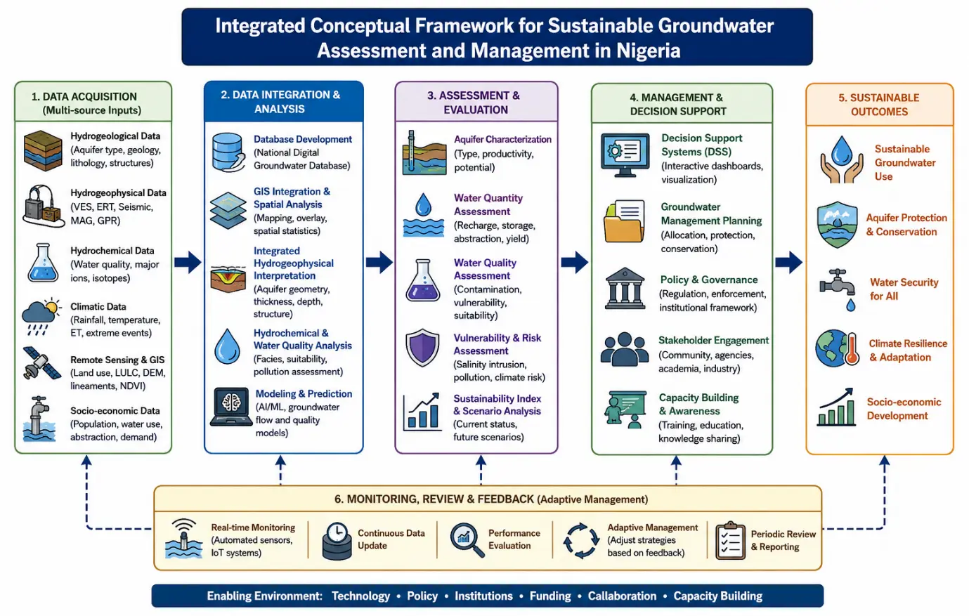
Figure 5. Integrated Conceptual Framework for Sustainable Groundwater Assessment and Management in Nigeria.
5. Conclusions
Groundwater remains one of the most important freshwater resources in Nigeria and plays a vital role in domestic water supply, agriculture, industrial activities, and environmental sustainability. This review synthesized existing studies on groundwater systems, aquifer characterization, hydrogeophysical investigations, groundwater quality, and sustainability challenges across different hydrogeological environments in Nigeria. The findings revealed significant hydrogeological variability associated with Basement Complex terrains, sedimentary basins, Coastal Plain Sands, and alluvial aquifers, resulting in differences in groundwater occurrence, recharge, productivity, and quality. Sedimentary formations such as the Niger Delta, Chad Basin, and Sokoto Basin generally exhibit high groundwater potential, whereas groundwater occurrence within Basement Complex regions is strongly controlled by weathering thickness and fracture systems.
The review further demonstrated that electrical resistivity techniques, particularly VES and ERT, remain the dominant methods for groundwater exploration and aquifer characterization in Nigeria. However, recent advances involving GIS integration, remote sensing, hydrochemical analysis, pumping tests, and machine learning approaches indicate a gradual transition toward more integrated and technology-driven groundwater assessment frameworks. Despite these developments, groundwater sustainability in Nigeria continues to face major environmental and anthropogenic pressures, including groundwater pollution, saline intrusion, excessive abstraction, oil-related contamination, and climate variability. Coastal aquifers within the Niger Delta, Lagos, and Akwa Ibom regions were identified as particularly vulnerable to seawater intrusion and hydrocarbon contamination.
The study emphasizes the urgent need for sustainable groundwater governance, integrated hydrogeophysical investigations, and long-term groundwater monitoring systems. The development of a centralized national groundwater database and the adoption of climate-resilient groundwater management strategies are essential for improving water security and environmental sustainability in Nigeria. Future research should prioritize interdisciplinary approaches integrating hydrogeophysics, hydrochemistry, GIS, remote sensing, groundwater modeling, and artificial intelligence to support evidence-based groundwater management and sustainable development. Future studies should also incorporate bibliometric and scientometric analyses, including keyword co-occurrence mapping and research trend visualization, to better identify emerging research themes, knowledge gaps, and collaborative networks within groundwater research in Nigeria.
Ethics Statement
Not applicable. This study is a scoping review based exclusively on previously published literature and did not involve human participants, animals, clinical data, or any experimental procedures requiring ethical approval.
Informed Consent Statement
Not applicable. This study did not involve human participants or the collection of personal or identifiable data.
Data Availability Statement
The data supporting the findings of this study are derived entirely from publicly available, peer-reviewed publications retrieved from Scopus, Web of Science, Google Scholar, ScienceDirect, and SpringerLink. All relevant data generated or analyzed during this review are included within the article and its reference list. No new datasets were created during the study.
Funding
This research received no external funding.
Declaration of Competing Interest
The author declares that there are no known competing financial interests or personal relationships that could have appeared to influence the work reported in this paper.
References
-
Agbasi OE, Etuk SE. Hydro-Geoelectric study of aquifer potentialin parts of Ikot Abasi Local Government Area, Akwa Ibom State using electrical resistivity soundings. Int. J. Geol. Earth Sci. 2016, 2, 43–53. DOI:10.4172/2325-9647.1000145 [Google Scholar]
-
Karandish F, Liu S, De Graaf I. Global groundwater sustainability: A critical review of strategies and future pathways. J. Hydrol. 2025, 657, 133060. DOI:10.1016/j.jhydrol.2025.133060 [Google Scholar]
-
Ndehedehe CE, Adeyeri OE, Onojeghuo AO, Ferreira VG, Kalu I, Okwuashi O. Understanding global groundwater-climate interactions. Sci. Total Environ. 2023, 904, 166571. DOI:10.1016/j.scitotenv.2023.166571 [Google Scholar]
-
Filimonau V, Barth JAC. From global to local and vice versa: On the importance of the ‘Globalization’ agenda in Continental Groundwater Research and Policy-Making. Environ. Manag. 2016, 58, 491–503. DOI:10.1007/s00267-016-0722-2 [Google Scholar]
-
Kunwar S, Mishra N, Khali H, Deep A. Impacts of climate change on groundwater resources: A comprehensive review. Front. Environ. Sci. 2026, 14, 1606354. DOI:10.3389/fenvs.2026.1606354 [Google Scholar]
-
Velis M, Conti KI, Biermann F. Groundwater and human development: Synergies and trade-offs within the context of the sustainable development goals. Sustain. Sci. 2017, 12, 1007–1017. DOI:10.1007/s11625-017-0490-9 [Google Scholar]
-
Sahuquillo A, Cassiraga E, Gómez-Hernández JJ, Andreu J, Pulido-Velazquez M, Pulido-Velazquez D, et al. Management alternatives of aquifer storage, distribution, and simulation in conjunctive use. Water 2022, 14, 2332. DOI:10.3390/w14152332 [Google Scholar]
-
Elsaidy A, Yimer EA, Mogheir Y, Huysmans M, Villani L, Van Griensven A. Groundwater drought and anthropogenic amplifiers: A review of assessment and response strategies in arid and semi-arid areas. Sci. Total Environ. 2025, 978, 179406. DOI:10.1016/j.scitotenv.2025.179406 [Google Scholar]
-
Lekshmy SAJ, Achari VS. Climate change impact on groundwater and soil geochemistry—Emerging challenges: A review. Appl. Water Sci. 2026, 16, 160. DOI:10.1007/s13201-026-02827-9 [Google Scholar]
-
Shehu B, Nazim F. Clean Water and Sanitation for All: Study on SDGs 6.1 and 6.2 Targets with State Policies and Interventions in Nigeria. Environ. Sci. Proc. 2022, 15, 71. DOI:10.3390/environsciproc2022015071 [Google Scholar]
-
Ben-Owope OA, Agbasi OE. Geo-electrical and hydrochemical characterization of unconfined aquifers in the Niger Delta: Implications for groundwater management and SDG achievement. Water Pract. Technol. 2025, 20, 2691–2717. DOI:10.2166/wpt.2025.157 [Google Scholar]
-
Rossetto R, Vescovo G, Bahnassy M, El-Kawy OA, El-Din RB, El-Sayed HM, et al. Achieving United Nations Sustainable Development Goal 6 through sustainable groundwater use in the Water-Energy-Food Nexus perspective in arid areas. Sustain. Horiz. 2025, 15, 100154. DOI:10.1016/j.horiz.2025.100154 [Google Scholar]
-
Etuk SE, Agbasi OE, Edet ES. Spatial distribution of Government and Donor Organization provided public water facilities in Uyo metropolis, Niger Delta Region, Nigeria, using Geographical Information System. World Sci. News 2018, 94, 217–235. [Google Scholar]
-
Agbasi OE, Aziz NA, Abdulrazzaq ZT, Etuk SE. Integrated geophysical data and GIS technique to forecast the potential groundwater locations in part of south eastern Nigeria. Iraqi J. Sci. 2019, 60, 1013–1022. DOI:10.24996/ijs.2019.60.5.11 [Google Scholar]
-
Ifeanyichukwu KA, Okeyeh E, Agbasi OE, Moses OI, Ben-Owope O. Using geo-electric techniques for vulnerability and groundwater potential analysis of aquifers in Nnewi, south eastern Nigeria. J. Geol. Geogr. Geoecol. 2021, 30, 43–52. DOI:10.15421/112105 [Google Scholar]
-
Okoli EA, Agbasi OE, Akaolisa CCZ, Ikoro DO, Ubechu BO, Ifeanyichukwu KA, et al. Investigation of groundwater potential utilizing geospatial techniques in Owerri, Nigeria. Geosci. Eng. 2024, 12, 30–56. DOI:10.33030/geosciences.2024.01.003 [Google Scholar]
-
Abdulrazzaq ZT, Al-Ansari N, Aziz NA, Agbasi OE, Etuk SE. Estimation of main aquifer parameters using geoelectric measurements to select the suitable wells locations in Bahr Al-Najaf depression, Iraq. Groundw. Sustain. Dev. 2020, 11, 100437. DOI:10.1016/j.gsd.2020.100437 [Google Scholar]
-
Umoh JA, Agbasi OE, George NJ, Mbong E, Aka MU. Hydrogeological assessment and aquifer potential of a coastal area, South Nigeria: Insights from VES surveys and spatial analysis. Water Pract. Technol. 2024, 19, 3373–3388. DOI:10.2166/wpt.2024.192 [Google Scholar]
-
Jimoh MO, Opawale GT, Ejepu JS, Abdullahi S, Agbasi OE. Investigation of groundwater potential using geological, hydrogeological and geophysical methods in Federal University of Technology, Minna, Bosso Campus, North Central, Nigeria. HydroResearch 2023, 6, 255–268. DOI:10.1016/j.hydres.2023.09.002 [Google Scholar]
-
Ejepu JS, Jimoh MO, Abdullahi S, Mba MA. Groundwater exploration using multi criteria decision analysis and analytic hierarchy process in Federal capital territory, Abuja, Central Nigeria. Int. J. Geosci. 2022, 13, 33–53. DOI:10.4236/ijg.2022.131003 [Google Scholar]
-
Isukuru EJ, Opha JO, Isaiah OW, Orovwighose B, Emmanuel SS. Nigeria’s water crisis: Abundant water, polluted reality. Clean. Water 2024, 2, 100026. DOI:10.1016/j.clwat.2024.100026 [Google Scholar]
-
Irene J, Irene BN, Daniels C. Not a drop to drink: Addressing Nigeria’s deepening freshwater crisis. Water 2025, 17, 1731. DOI:10.3390/w17121731 [Google Scholar]
-
Adewumi R, Agbasi O, Mayowa A. Investigating groundwater potential in northeastern basement complexes: A Pulka case study using geospatial and geo-electrical techniques. HydroResearch 2023, 6, 73–88. DOI:10.1016/j.hydres.2023.02.003 [Google Scholar]
-
Tanko AI, Lawan AY, Tijjani RD. Overview of groundwater occurrence, quality, and challenges in Nigeria. In Earth Sciences; IntechOpen: London, UK, 2024. DOI:10.5772/intechopen.1006981 [Google Scholar]
-
OlaOlorun OA, Akinola OO. Migmatite-Gneiss-Granite Basement of Southwestern Nigeria: Mineralogical and geochemical evidence for a possible CommonAncient Protolith. J. Earth Environ. Sci. Res. 2024, 224, 2–14. DOI:10.47363/JEESR/2024(6)224 [Google Scholar]
-
Idris M, Garba M, Kasim S, Madabo I, Dandago K. The role of geological structures on groundwater occurrence and flow in crystalline basement aquifers: A status review. Bayero J. Pure Appl. Sci. 2018, 11, 155–164. DOI:10.4314/bajopas.v11i1.27 [Google Scholar]
-
Aizebeokhai AP, Oyeyemi KD, Joel ES. Groundwater potential assessment in a sedimentary terrain, southwestern Nigeria. Arab. J. Geosci. 2016, 9, 496. DOI:10.1007/s12517-016-2524-5 [Google Scholar]
-
Udosen NI, George NJ. Evaluation of specific retention, specific yield, and storage-dependent drainability efficiency in a coastal milieu via geo-electrical technology. Water Pract. Technol. 2024, 19, 3654–3675. DOI:10.2166/wpt.2024.208 [Google Scholar]
-
Ikpe EO, Ekanem AM, George NJ, Thomas JE. Geophysical assessment of aquifer protectivity, groundwater potential and flow dynamics in Northern Akwa Ibom state, Nigeria: Implications for sustainable freshwater management. Geosyst. Geoenviron. 2025, 4, 100401. DOI:10.1016/j.geogeo.2025.100401 [Google Scholar]
-
Ekanem AM, George NJ, Thomas JE. Investigation of aquifer storage properties and groundwater contamination risk potential using an electrical resistivity technique: A sedimentary environment case study. Water Pract. Technol. 2024, 19, 3350–3372. DOI:10.2166/wpt.2024.203 [Google Scholar]
-
Adamu S, Sadiq HM, Kodomi M, Wulo I. Groundwater depletion in the upper aquifer of the chad formation, Chad basin, North-Eastern Nigeria. Niger. J. Technol. 2020, 39, 621–631. DOI:10.4314/njt.v39i2.34 [Google Scholar]
-
Wali SU, Alias N, Harun SB. Hydrogeochemical evaluation and mechanisms controlling groundwater in different geologic environments, Western Sokoto Basin, Northwestern Nigeria. SN Appl. Sci. 2020, 2, 1808. DOI:10.1007/s42452-020-03589-y [Google Scholar]
-
Joshua AK, John IA, Ikechukwu ED, Ebuka AO. Scrutinate proclivity of regional aquifer hydraulic parameters: Apriorisms for borehole failures within parts of the middle Benue Trough, Nigeria. Water Pract. Technol. 2023, 18, 3347–3364. DOI:10.2166/wpt.2023.211 [Google Scholar]
-
Ibrahim IO, Oseiza LM, Ali AY, Oloyede OI, Kareem AK. Climate change variability and impacts on aquifers performance and groundwater production at Akerebiata area, Nigeria. Prog. A J. Multidiscip. Stud. 2024, 5, 37–51. DOI:10.71016/tp/tx90aa04 [Google Scholar]
-
Zacchaeus OO, Adeyemi MB, Adedeji AA, Adegoke KA, Anumah AO, Taiwo AM, et al. Effects of industrialization on groundwater quality in Shagamu and Ota industrial areas of Ogun state, Nigeria. Heliyon 2020, 6, e04353. DOI:10.1016/j.heliyon.2020.e04353 [Google Scholar]
-
Alao JO, Abdulsalami M, Mohammed MA, Eze SU. Groundwater contamination due to hydrocarbon extraction activities in the Niger Delta: A potential challenge towards sustainable environment and public health. Water-Energy Nexus 2025, 9, 93–108. DOI:10.1016/j.wen.2025.12.002 [Google Scholar]
-
Eyankware MO, Mba-Otike MN, Odesa GE, Chukwusa FO, Osisanya WO, Eyankware-Ulakpa RO, et al. Saline intrusion in Niger Delta coastal aquifers, drivers, hydrogeological dynamics and mitigation strategies. Discov. Geosci. 2025, 3, 150. DOI:10.1007/s44288-025-00264-w [Google Scholar]
-
Lubi SP, Akinluyi FO. Groundwater hydrocarbon contamination spatial pattern in Opuama, Western Niger-Delta, Nigeria. Environ. Earth Sci. 2022, 81, 121. DOI:10.1007/s12665-022-10250-x [Google Scholar]
-
Akingboye AS, Bery AA, Kayode JS, Asulewon AM, Bello R, Agbasi OE. Near-Surface Crustal Architecture and Geohydrodynamics of the Crystalline Basement Terrain of Araromi, Akungba-Akoko, SW Nigeria, Derived from Multi-Geophysical Methods. Nat. Resour. Res. 2022, 31, 215–236. DOI:10.1007/s11053-021-10000-z [Google Scholar]
-
Ibuot JC, Aka MU, Inyang NJ, Agbasi OE. Georesistivity and physicochemical evaluation of hydrogeologic units in parts of Akwa Ibom State, Nigeria. Int. J. Energy Water Resour. 2022, 8, 111–122. DOI:10.1007/s42108-022-00191-3 [Google Scholar]
-
Kumar P, Sharma PK, Kumar S. Basin-scale groundwater recharge potential mapping in the Yamuna river basin using AHP and MIF with long-term groundwater level analysis. J. Hydroinform. 2026, 28, 283–310. DOI:10.2166/hydro.2026.146 [Google Scholar]
-
Saber M, Kantoush SA, Sumi T, Sefelnasr A, Alshamsi D, Gad A, et al. Enhancing groundwater recharge mapping in arid regions with geospatial multi-criteria analysis in the Eastern desert of Egypt. Sci. Rep. 2026, 16, 11347. DOI:10.1038/s41598-026-39134-x [Google Scholar]
-
Ishfaq M, Ullah S, Hussain R, Khalid M, Khattak Z, Rani S, et al. Delineation of Groundwater Potential Zones Using GIS, Remote Sensing and Multi Influencing Factor Techniques in Bannu District, Khyber Pakhtunkhwa. Spectr. Eng. Sci. 2026, 4, 436–463. DOI:10.5281/zenodo.18677642 [Google Scholar]
-
Okoli E, Akaolisa CCZ, Ubechu BO, Agbasi OE, Szafarczyk A. Using VES and GIS-Based DRASTIC analysis to evaluate groundwater aquifer contamination vulnerability in Owerri, southeastern Nigeria. Ecol. Quest. 2024, 35, 1–27. DOI:10.12775/eq.2024.031 [Google Scholar]
-
García-Ávila F, Huanga-Huanga E, Méndez-Valladares V, Peñaloza-Zhispón U, Valdiviezo-Gonzales L, Sánchez-Cordero E. Exploring groundwater quality through key parameters and management tools for its conservation and recovery. Environ. Sustain. Indic. 2025, 27, 100767. DOI:10.1016/j.indic.2025.100767 [Google Scholar]
-
Page MJ, Moher D, Bossuyt PM, Boutron I, Hoffmann TC, Mulrow CD, et al. PRISMA 2020 explanation and elaboration: Updated guidance and exemplars for reporting systematic reviews. BMJ 2021, 372, n160. DOI:10.1136/bmj.n160 [Google Scholar]
-
Westphaln KK, Regoeczi W, Masotya M, Vazquez-Westphaln B, Lounsbury K, McDavid L, et al. From Arksey and O’Malley and Beyond: Customizations to enhance a team-based, mixed approach to scoping review methodology. MethodsX 2021, 8, 101375. DOI:10.1016/j.mex.2021.101375 [Google Scholar]
-
Santos WMD, Secoli SR, De Araújo Püschel VA. The Joanna Briggs Institute approach for systematic reviews. Rev. Lat. Am. De Enferm. 2018, 26, e3074. DOI:10.1590/1518-8345.2885.3074 [Google Scholar]
-
Okon E, Falana B, Solaja S, Yakubu S, Alabi O, Okikiola B, et al. Systematic review of climate change impact research in Nigeria: Implication for sustainable development. Heliyon 2021, 7, e07941. DOI:10.1016/j.heliyon.2021.e07941 [Google Scholar]
-
Umar N, Gray A. Flooding in Nigeria: A review of its occurrence and impacts and approaches to modelling flood data. Int. J. Environ. Stud. 2022, 80, 540–561. DOI:10.1080/00207233.2022.2081471 [Google Scholar]
-
Nicholas DO, Raimi MO. Silent Contamination Beneath: Groundwater Quality, Health Risks, and Policy Implications in Bayelsa’s Oil-Producing Communities. Open J. Phys. Chem. 2025, 15, 41–73. DOI:10.4236/ojpc.2025.153004 [Google Scholar]
-
Okonkwo JE, Agbasi OE, Igili CO. Evaluating the spatial influence of topography and land use on aquifer transmissivity in sedimentary terrains of Delta State, Nigeria. Int. J. Energy Water Resour. 2025, 9, 2061–2077. DOI:10.1007/s42108-025-00375-7 [Google Scholar]
-
George NJ, Ekanem AM, Agbasi OE, Ibuot JC, Udo KI, Ejepu JS, et al. Machine-learning-integrated hydrogeophysical–geochemical assessment of soil–water interface dynamics for groundwater sanitation in Akwa Ibom State University, Nigeria. Int. J. Energy Water Resour. 2026, 10, 61. DOI:10.1007/s42108-026-00487-8 [Google Scholar]
-
Aka MU, Archibong RA, Agbasi OE. Assessment of water quality parameters in Iwuru, South-South Nigeria: Implications for potability and environmental health. Clean. Water 2025, 4, 100172. DOI:10.1016/j.clwat.2025.100172 [Google Scholar]
-
Ferreira CS, Adama-Ajonye O, Ikenna AE, Kalantari Z. Groundwater quality in the vicinity of a dumpsite in Lagos metropolis, Nigeria. Geogr. Sustain. 2023, 4, 379–390. DOI:10.1016/j.geosus.2023.09.005 [Google Scholar]
-
Yusuf S, Ishaku J, Wakili W. Estimation of Dar-Zarrouk parameters and delineation of groundwater potential zones in Karlahi, part of Adamawa Massif, Northeastern Nigeria. War. Geol. 2021, 47, 103–112. DOI:10.7186/wg472202101 [Google Scholar]
-
Oyebode OJ, Adewoye OA, Jimoh MT. Seasonal variability and risk assessment of heavy metals in shallow groundwater of selected areas in Oyo Town, southwestern Nigeria. J. Geogr. Environ. Earth Sci. Int. 2025, 29, 137–149. DOI:10.9734/jgeesi/2025/v29i12988 [Google Scholar]
-
Bassey EN, Ajani OO, Isah A, Adeniji AA. Geophysical investigation of groundwater potential in Iwo, Osun State, Southwestern Nigeria using audiomagnetotelluric method. Results Geophys. Sci. 2024, 16, 100066. DOI:10.1016/j.ringps.2023.100066 [Google Scholar]
-
Aladeboyeje AI, Adenoye TT, Agbasi OE. Assessment of groundwater vulnerability using GOD index and Dar Zarrouk parameters: A case study of OAUSTECH main campus, Okitipupa, Ondo State. Results Earth Sci. 2024, 2, 100036. DOI:10.1016/j.rines.2024.100036 [Google Scholar]
-
Olayiwola O, Tokunbo F, Bosede O, Joel A, Ajibola O. Geophysical assessment of groundwater vulnerability to diesel contamination at a telecommunication mast in Adebayo area, Ado-Ekiti, southwestern Nigeria. Ann. Sci. Technol. 2021, 6, 1–8. DOI:10.2478/ast-2021-0001 [Google Scholar]
-
Aladeboyeje AI, Coker JO, Agbasi OE, Inyang NJ. Integrated hydrogeophysical assessment of groundwater potential in the Ogun drainage basin, Nigeria. Int. J. Energy Water Resour. 2021, 5, 461–475. DOI:10.1007/s42108-021-00121-9 [Google Scholar]
-
Yusuf M, Omolaiye GE, Oluyemoh AO, Ajadi J, Adam SB, Egbeyale GB, et al. Hydrogeological assessment of groundwater potential zones using remote sensing, geographical information system (GIS) and aeromagnetic data at Kwara State University, Malete, Nigeria. Discov. Water 2025, 5, 72. DOI:10.1007/s43832-025-00273-3 [Google Scholar]
-
Shuaibu A, Kalin RM, Phoenix V, Banda LC, Hinton RG. Investigation of groundwater recharge in the transboundary Komadugu–Yobe basin Nigeria via stable isotopes of δ18O and δ2H and comparison with the wider Sahel, Africa. Sci. Total Environ. 2025, 994, 180043. DOI:10.1016/j.scitotenv.2025.180043 [Google Scholar]
-
Wali SU, Alias NB, Harun SB, Umar KJ, Gada MA, Dankani IM, et al. Water quality indices and multivariate statistical analysis of urban groundwater in semi-arid Sokoto Basin, Northwestern Nigeria. Groundw. Sustain. Dev. 2022, 18, 100779. DOI:10.1016/j.gsd.2022.100779 [Google Scholar]
-
Egbueri JC, Agbasi JC, Onuba LN, Nweke ND, Uwajingba HC, Abba SI. Groundwater development within the Nigerian crystalline and sedimentary aquifers: Challenges and opportunities. In Springer Water; Springer: Cham, Switzerland, 2025; pp. 297–325. DOI:10.1007/978-3-031-79122-2_13 [Google Scholar]
-
Nanfa CA, Kizito MO, Akpah FA, Shaibu MM, Bolaji JJ, Aminu MB, et al. Investigation of basement aquifer hydraulics and protective capacity within Jimgbe and environs, North Central Nigeria. Commun. Phys. Sci. 2025, 12, 696–709. DOI:10.4314/cps.v12i3.4 [Google Scholar]
-
Ilugbo SO, Adewoye OE, Aladeboyeje AI, Magawata UZ, Oyedele AA, Alabi TO, et al. Modeling of groundwater potential using remotely sensed data within Akure metropolis, Ondo State, Southwestern Nigeria. Appl. J. Phys. Sci. 2020, 2, 38–54. DOI:10.31248/ajps2020.028 [Google Scholar]
-
Ijila P, Kolebaje O, Ojo AO, Akinyemi P. Geophysical characterization of the basement rocks and groundwater potential zones using electrical resistivity sounding technique. J. Environ. Earth Sci. 2018, 8, 21–33. [Google Scholar]
-
Sunkari ED, Kore BM, Abioui M. Hydrogeophysical appraisal of groundwater potential in the fractured basement aquifer of the federal capital territory, Abuja, Nigeria. Results Geophys. Sci. 2021, 5, 100012. DOI:10.1016/j.ringps.2021.100012 [Google Scholar]
-
Bayowa OG, Ogungbesan GO, Adelere IO, Olasunkanmi NK, Olatunbosun AS, Alagbe AO. Groundwater potential assessment of shallow aquifers in the basement complex underlain Osogbo metropolis, Southwest Nigeria, using geo-electric attributes. Environ. Earth Sci. 2023, 82, 239. DOI:10.1007/s12665-023-10907-1 [Google Scholar]
-
Ekwok SE, Akpan AE, Kudamnya EA, Ebong ED. Assessment of groundwater potential using geophysical data: A case study in parts of Cross River State, south-eastern Nigeria. Appl. Water Sci. 2020, 10, 144. DOI:10.1007/s13201-020-01224-0 [Google Scholar]
-
Shuaibu A, Umoru CI. Delineation of groundwater potential zone using remote sensing and GIS techniques within Zamfara region, North West Nigeria. Niger. J. Technol. 2025, 44, 497–506. DOI:10.4314/njt.v44i3.13 [Google Scholar]
-
Vaquero G, Siavashani NS, García-Martínez D, Elorza FJ, Bila M, Candela L, et al. The Lake Chad transboundary aquifer. Estimation of groundwater fluxes through international borders from regional numerical modeling. J. Hydrol. Reg. Stud. 2021, 38, 100935. DOI:10.1016/j.ejrh.2021.100935 [Google Scholar]
-
Wali SU, Alias NB, Usman AA, Umar A, Muhammad N, Kaoje IU, et al. Hydrochemical characterization and seasonal variability of shallow groundwater in the Sokoto basin northern Nigeria rock weathering as a dominant control factor. Discov. Geosci. 2025, 3, 122. DOI:10.1007/s44288-025-00228-0 [Google Scholar]
-
George NJ, Agbasi OE, Umoh JA, Ekanem AM, Ejepu JS, Thomas JE, et al. Contribution of electrical prospecting and spatiotemporal variations to groundwater potential in coastal hydro-sand beds: A case study of Akwa Ibom State, Southern Nigeria. Acta Geophys. 2022, 71, 2339–2357. DOI:10.1007/s11600-022-00994-2 [Google Scholar]
-
George NJ, Bassey NE. Geoelectric and hydro-geochemical assessments of waterlogging and drainage for soil and agronomic groundwater evaluation at Akwa Ibom State University: Field and laboratory data mining approaches. Geosyst. Geoenviron. 2025, 5, 100464. DOI:10.1016/j.geogeo.2025.100464 [Google Scholar]
-
Abubakar IT, Maharazu AY, Emmanuel AO, Adnan A. Shallow groundwater condition for irrigation along dryland river basin, northwestern Nigeria. J. Dryland Agric. 2018, 4, 1–11. DOI:10.5897/joda2018.0003 [Google Scholar]
-
Eduvie MO, Garba ML. Appraisal of Groundwater Potential of Fadama Areas within Northern Nigeria: A Review. J. Geosci. Environ. Prot. 2021, 9, 44–57. DOI:10.4236/gep.2021.93004 [Google Scholar]
-
Mallam I, Amoo AO, Abdulhamid AI. Impact of borehole characteristics and aquifer properties on groundwater quantity for sustainable rural water supply in Jigawa State, Nigeria. J. Appl. Sci. Environ. Manag. 2025, 29, 2391–2399. DOI:10.4314/jasem.v29i8.2 [Google Scholar]
-
Akiang FB, Nnaji VN, Opara AI, Agoha CC, Agbasi OE, Ulem EB, et al. Geospatial and geo-electrical assessment of groundwater vulnerability and potential in parts of Cross River, Southern Nigeria. HydroResearch 2024, 8, 58–73. DOI:10.1016/j.hydres.2024.09.007 [Google Scholar]
-
Okonkwo JE, Agbasi OE, Igili CO. Integrated GIS and Remote Sensing-Based evaluation for groundwater potential zoning in part of Delta State, Nigeria. Water Conserv. Sci. Eng. 2025, 10, 125. DOI:10.1007/s41101-025-00450-4 [Google Scholar]
-
Badmus GO, Akinyemi OD, Gbadebo AM, Oyedepo JA, Folarin GM. Assessment of seasonal variation of saltwater intrusion using integrated geophysical and hydrochemical methods in some selected part of Ogun Waterside, Southwest, Nigeria. Environ. Earth Sci. 2021, 80, 99. DOI:10.1007/s12665-021-09379-y [Google Scholar]
-
Lawal II, Idris M. Geophysical investigation of subsurface water using electrical resistivity techniques in Kibiya Local Government, Kano State, Nigeria. Dutse J. Pure Appl. Sci. 2025, 11, 345–361. DOI:10.4314/dujopas.v11i3b.35 [Google Scholar]
-
Isah A, Bassey EN, Akinbiyi OA, Azeez RA, Oji AS, El-Badawy T. Characterizing groundwater contamination flow-paths and heavy metal mobilization near a waste site in Southwestern Nigeria. J. Afr. Earth Sci. 2024, 221, 105460. DOI:10.1016/j.jafrearsci.2024.105460 [Google Scholar]
-
Adiat K. Application of geophysical borehole logs for aquifer characterization in coastal environment of Lagos, southwestern Nigeria. Niger. J. Basic Appl. Sci. 2019, 26, 31. DOI:10.4314/njbas.v26i1.4 [Google Scholar]
-
Anomohanran O, Orhiunu ME. Assessment of groundwater occurrence in Olomoro, Nigeria using borehole logging and electrical resistivity methods. Arab. J. Geosci. 2018, 11, 219. DOI:10.1007/s12517-018-3582-7 [Google Scholar]
-
Ibrahim D, Nemoto T, Raghavan V. Spatial modelling of groundwater potential zones using GIS-Based Machine Learning techniques: A case study of Abuja, Nigeria. Geosciences 2026, 16, 195. DOI:10.3390/geosciences16050195 [Google Scholar]
-
Saidu AA, Aldrees A, Dan’azumi S, Abba SI, Hamza SM. Groundwater potential mapping in semi-arid region of Northern Nigeria by integrating analytic hierarchy process and GIS. Front. Water 2024, 6, 1484753. DOI:10.3389/frwa.2024.1484753 [Google Scholar]
-
Okereke CS, Edet A. An integrated approach for aquifer characterization and evaluation in a complex geologic terrain (Cross River State, Nigeria): A contribution to support sustainable development and management of groundwater. J. Afr. Earth Sci. 2023, 201, 104894. DOI:10.1016/j.jafrearsci.2023.104894 [Google Scholar]
-
Bello M, Oladapo M, Abraham-A, Orji O. Aquifer integrity test using the Dar Zarouk parameters in Emure Ekiti Southwestern Nigeria. Results Earth Sci. 2025, 3, 100087. DOI:10.1016/j.rines.2025.100087 [Google Scholar]
-
Ebong ED, Emeka CN, Melouah O, Ullah RI, Ita AE, Asfahani J. Delineation of groundwater potential zones using electrical resistivity technique in Obudu basement terrain of Cross River State, Southeastern Nigeria. Water Pract. Technol. 2023, 18, 2884–2900. DOI:10.2166/wpt.2023.174 [Google Scholar]
-
Ugbor CC, Ogbodo UK. Estimation of aquifer transmissivity using Dar Zarrouk parameters at Ogbozara-Ekwegbe-Agu and the environ, Enugu State, Nigeria. Open J. Geol. 2023, 13, 783–805. DOI:10.4236/ojg.2023.138035 [Google Scholar]
-
Akintola OA, Sajo OS, Olaleye OS. Assessing groundwater quality and pollution hotspots using simple fuzzy classification in a rapidly urbanizing region. Next Sustain. 2025, 6, 100171. DOI:10.1016/j.nxsust.2025.100171 [Google Scholar]
-
Nlemolisa O, Ogbulie J, Orji J, Nweke C, Kemka U, Gaius-Mbalisi V, et al. Groundwater contamination and health risks near waste dumps and mechanic workshops: A seasonal perspective. Clean. Water 2025, 4, 100090. DOI:10.1016/j.clwat.2025.100090 [Google Scholar]
-
Edegbai AJ, Pajiah JA, Egbuchunam DA, Iyeke MU, Omietimi EJ, Lenhardt N. Assessment of groundwater and storage water quality contamination at the University of Benin campus, Southern Nigeria. Discov. Water 2026, 6, 58. DOI:10.1007/s43832-026-00379-2 [Google Scholar]
-
Oyem HH, Oyem IM, Usese AI. Iron, manganese, cadmium, chromium, zinc and arsenic groundwater contents of Agbor and Owa communities of Nigeria. SpringerPlus 2015, 4, 104. DOI:10.1186/s40064-015-0867-0 [Google Scholar]
-
Obasi PN, Akudinobi BB. Potential health risk and levels of heavy metals in water resources of lead–zinc mining communities of Abakaliki, southeast Nigeria. Appl. Water Sci. 2020, 10, 184. DOI:10.1007/s13201-020-01233-z [Google Scholar]
-
Ojo OT, Ike CJ, Aladeboyeje AI, Olaseeni OG, Adewumi OF. Hydrochemical assessment of borehole water in Effurun, Delta state Niger Delta, Nigeria: Implications for public health and safety. Discov. Geosci. 2025, 3, 10. DOI:10.1007/s44288-025-00117-6 [Google Scholar]
-
Bencheikh A, Bouznad IE, Zebsa R, Ziouch OR, Bensakhri Z, Belksier M, et al. Nitrate contamination in deep aquifers: Health risks and spatiotemporal analysis in an arid region of the Algerian Sahara. Desalination Water Treat. 2025, 322, 101239. DOI:10.1016/j.dwt.2025.101239 [Google Scholar]
-
Tope OO, Adejimi AJ, Emeka OA, Josphe IN. In-depth examination of physicochemical parameters of borehole water samples in Borokiri, Niger Delta. J. Penelit. Fis. Dan Apl. 2024, 14, 125–142. DOI:10.26740/jpfa.v14n2.p125-142 [Google Scholar]
-
Akoteyon IS. Hydrochemical studies of ground water in parts of Lagos, southwestern Nigeria. Bull. Geogr. Phys. Geogr. Ser. 2013, 6, 27–42. DOI:10.2478/bgeo-2013-0002 [Google Scholar]
-
Aleku DL, Biester H, Pichler T. Pipeline-Related residential benzene exposure and groundwater natural attenuation capacity in the eastern Niger Delta, Nigeria. Environments 2024, 11, 221. DOI:10.3390/environments11100221 [Google Scholar]
-
Wanjala PM, Opoku BK, Ibisime E, Wafula EN. Assessment of the impact of benzene, toluene, ethylbenzene, and xylene (BTEX) on soil microbial population in selected areas of Port Harcourt City, Nigeria. Sci. Afr. 2025, 27, e02525. DOI:10.1016/j.sciaf.2024.e02525 [Google Scholar]
-
Ubuoh EA, Nwogu FU, Ossai-Abeh EQ, Ikwuemesi JC, Oke AO, Umoh JD. Evaluation of hydro-chemical facies and surface water quality dynamics using multivariate statistical approaches in Southern Nigeria. Sci. Rep. 2024, 14, 31600. DOI:10.1038/s41598-024-77534-z [Google Scholar]
-
Otobo IT, Inengite AK. Characterization of hydrochemical facies of groundwater in Tombia community in Bayelsa State, Nigeria. Afr. J. Environ. Nat. Sci. Res. 2026, 9, 12. DOI:10.52589/ajensr-xvhfdrag [Google Scholar]
-
Callistus O, Daniel AD, Pelumi AO, Somtobe O, Kunle O, Echezona OS, et al. An assessment of saltwater intrusion in coastal regions of Lagos, Nigeria. J. Geosci. Environ. Prot. 2024, 12, 93–119. DOI:10.4236/gep.2024.121007 [Google Scholar]
-
Alabi TO, Ilugbo SO, Akinmoye OE, Ibitomi MA, Aigbedion I, Adeleke KA, et al. Application of Electrical Resistivity and Hydrochemistry Methods for Mapping Groundwater Contamination around Okun Ilashe Island Area, Lagos State, Southwestern Nigeria. J. Geogr. Environ. Earth Sci. Int. 2019, 23, 1–15. DOI:10.9734/jgeesi/2019/v23i430184 [Google Scholar]
-
Oloruntola MO, Folorunso AF, Ojeyomi BA, Ashiru OR. Geophysical assessment of seawater intrusion in Apapa-Ajegunle, coastal area of Lagos, Southwestern Nigeria. Sci. Rep. 2026, 16, 5498. DOI:10.1038/s41598-026-35120-5 [Google Scholar]
-
Badmus GO, Fagbohun BJ, Ogungbemi OS, Akinyemi OD, Gbadebo AM, Oyedepo JA. Delineation of potential zones for groundwater recharge using integrated GIS-based AHP and CSI techniques in Ogun Waterside, Southwestern Nigeria. Water Sci. Technol. Water Supply 2024, 24, 3326–3342. DOI:10.2166/ws.2024.220 [Google Scholar]
-
Inyang N, George N, Ehibor I, Ekot A, Udo I. Ingress of municipal solid waste into water resources: An environmental assessment and monitoring tool near dumpsites in Akwa Ibom State, Nigeria. Water Pract. Technol. 2024, 19, 3182–3202. DOI:10.2166/wpt.2024.187 [Google Scholar]
-
Ihenetu SC, Jude CA, Nwadiogbu JO, Enyoh CE. Groundwater quality assessment for irrigation and drinking water: Health risks from heavy metals and PAHs in the Niger Delta, Nigeria. AQUA—Water Infrastruct. Ecosyst. Soc. 2024, 73, 2013–2029. DOI:10.2166/aqua.2024.205 [Google Scholar]
-
George D, Hart A, Osuji L. Concentration of heavy metals and petroleum hydrocarbons in previously remediated sites in Niger Delta, Nigeria. Sci. Afr. 2022, 20, 53–72. DOI:10.4314/sa.v20i3.6 [Google Scholar]
-
Olabode OF, Comte J. Water scarcity in the fast-growing megacity of Lagos, Nigeria and opportunities for managed aquifer recharge. Wiley Interdiscip. Rev. Water 2024, 11, e1733. DOI:10.1002/wat2.1733 [Google Scholar]
-
Yusuf M, Abiye T. Risks of groundwater pollution in the coastal areas of Lagos, southwestern Nigeria. Groundw. Sustain. Dev. 2019, 9, 100222. DOI:10.1016/j.gsd.2019.100222 [Google Scholar]
-
George N, Ekanem A, Thomas J, Udosen N, Ossai N, Atat J. Electro-sequence valorization of specific enablers of aquifer vulnerability and contamination: A case of index-based model approach for ascertaining the threats to quality groundwater in sedimentary beds. HydroResearch 2023, 7, 71–85. DOI:10.1016/j.hydres.2023.11.006 [Google Scholar]
-
Ogunrinde AT, Oguntunde PG, Akinwumiju AS, Fasinmirin JT. Analysis of recent changes in rainfall and drought indices in Nigeria, 1981–2015. Hydrol. Sci. J. 2019, 64, 1755–1768. DOI:10.1080/02626667.2019.1673396 [Google Scholar]
-
Gbadebo AM, Ofili E, Makanjuola OO, Samuel CE, Francis VJ, Michael TK, et al. Hydrocarbon contamination and public health risks: A comparative groundwater quality and microbial load analysis in Abeokuta and the Niger Delta, Nigeria. Environ. Pollut. Manag. 2026, 3, 264–277. DOI:10.1016/j.epm.2026.04.001 [Google Scholar]
-
Ovuru C, Okujagu CD, Amgbare PE. Hydrogeochemical Characterization and Public Health Risk Assessment of Shallow Aquifers in the Flood-Prone Odi Community, Niger Delta. Int. J. Progress. Res. Eng. Manag. Sci. 2025, 5, 427–435. DOI:10.5281/zenodo.17901664 [Google Scholar]
-
Dasho OA, Ariyibi EA, Akinluyi FO, Awoyemi MO, Adebayo AS. Application of satellite remote sensing to groundwater potential modeling in Ejigbo area, Southwestern Nigeria. Model. Earth Syst. Environ. 2017, 3, 615–633. DOI:10.1007/s40808-017-0322-z [Google Scholar]
-
Ogunkoya CO. A review: The Role of Electrical Resistivity in Groundwater Exploration and Management. J. Multidiscip. Sci. MIKAILALSYS 2025, 3, 833–845. DOI:10.58578/mikailalsys.v3i2.5666 [Google Scholar]
-
Malahlela OE, Mothapo MC, Mathivha FI, Hlengwa N. Progress in the application of remote sensing for water quality and human health mapping in informal settlements of South Africa: A review. Sci. Afr. 2025, 28, e02718. DOI:10.1016/j.sciaf.2025.e02718 [Google Scholar]
-
Abdullateef L, Tijani MN, Nuru NA, John S, Mustapha A. Assessment of groundwater recharge potential in a typical geological transition zone in Bauchi, NE-Nigeria using remote sensing/GIS and MCDA approaches. Heliyon 2021, 7, e06762. DOI:10.1016/j.heliyon.2021.e06762 [Google Scholar]
-
Raji W, Asaoye T. Aquifer Productivity Evaluation Using Borehole Pumping Test and Geophysical Surveys. In 85th EAGE Annual Conference & Exhibition; European Association of Geoscientists & Engineers: Bunnik, The Netherlands, 2024; pp. 1–5. [Google Scholar]
-
Lapworth DJ, Nkhuwa DCW, Okotto-Okotto J, Pedley S, Stuart ME, Tijani MN, et al. Urban groundwater quality in sub-Saharan Africa: Current status and implications for water security and public health. Hydrogeol. J. 2017, 25, 1093–1116. DOI:10.1007/s10040-016-1516-6 [Google Scholar]
-
Adeniran MA, Oladunjoye MA, Doro KO. Soil and groundwater contamination by crude oil spillage: A review and implications for remediation projects in Nigeria. Front. Environ. Sci. 2023, 11, 1137496. DOI:10.3389/fenvs.2023.1137496 [Google Scholar]
-
Alao JO, Bello A, Lawal H, Abdullahi D. Assessment of groundwater challenge and the sustainable management strategies. Results Earth Sci. 2024, 2, 100049. DOI:10.1016/j.rines.2024.100049 [Google Scholar]
-
Ukpai SN. Water policy reform in the Nigeria water governance system: Assessment of water resources management based on OECD Principles on Water Governance. Water Policy 2022, 24, 1704–1722. DOI:10.2166/wp.2022.135 [Google Scholar]
-
Obeta MC. Rural water supply in Nigeria: Policy gaps and future directions. Water Policy 2018, 20, 597–616. DOI:10.2166/wp.2018.129 [Google Scholar]
-
Oyeyemi KD, Abuka-Joshua J, Rotimi OJ, Dieppois B, Gomo M, Olaojo AA, et al. Geoelectrical characterization of coastal aquifers in Agbado-Ijaye, Lagos, southwestern Nigeria; Implications for groundwater resources sustainability. Sustainability 2023, 15, 3538. DOI:10.3390/su15043538 [Google Scholar]
-
Marere OS, Allen EE. Integrated Geophysical and Geochemical Approach to Investigate Contamination of Aquifer Potential in Abandoned Dumpsite in Ogbovwan Town, Ughelli-North Local Government Area, Delta State, Nigeria. Med. Res. Chron. 2024, 10, 121–150. DOI:10.26838/jusres.2024.10.6.609 [Google Scholar]
-
Ajadi J, Yusuf M, Omolaiye GE, Adam SB, Alade AD. Evaluation of groundwater resources using remote sensing and GIS techniques within Kwara State University, Malete, Nigeria. Discov. Geosci. 2025, 3, 127. DOI:10.1007/s44288-025-00244-0 [Google Scholar]
-
Wu H, Zhang Z, Wang P, Liang C, Liu Y, Wang Y, et al. Machine learning for the spatial prediction of soil and groundwater contamination: An integrative global review. J. Hazard. Mater. 2026, 513, 142518. DOI:10.1016/j.jhazmat.2026.142518 [Google Scholar]
-
Doro K, Ehosioke S, Aizebeokhai A. Sustainable Soil and Water Resources Management in Nigeria: The Need for a Data-Driven Policy Approach. Sustainability 2020, 12, 4204. DOI:10.3390/su12104204 [Google Scholar]
-
Siyad SA, Mohamed ZH. A systematic literature review on groundwater recharge dynamics under climate variability, land use change and sea level rise. Discov. Sustain. 2025, 6, 1331. DOI:10.1007/s43621-025-02232-3 [Google Scholar]
-
Yazdani M, Van Thienen P, Stofberg SF, Van Huijgevoort MH, Bartholomeus RP. Managed Aquifer Recharge: Modeling approaches to integrated assessment of groundwater interventions. Groundw. Sustain. Dev. 2025, 32, 101552. DOI:10.1016/j.gsd.2025.101552 [Google Scholar]
-
Oloyede MO, Williams AB, Ode GO, Benson NU. Coastal Vulnerability Assessment: A case study of the Nigerian coastline. Sustainability 2022, 14, 2097. DOI:10.3390/su14042097 [Google Scholar]
-
Agbonaye AI, Izinyon OC. Nigerian coastal region’s vulnerability to climate change. NIPES-J. Energy Technol. Environ. 2024, 6, 32–48. DOI:10.5281/zenodo.10823101 [Google Scholar]