
The Euphrates River Flooding Event of May–June 2026: Hydrological Analysis, Transboundary Water Management, and Institutional Dimensions

The Euphrates River Flooding Event of May–June 2026: Hydrological Analysis, Transboundary Water Management, and Institutional Dimensions

Received: 08 June 2026 Revised: 29 June 2026 Accepted: 27 July 2026 Published: 05 August 2026

© 2026 The authors. This is an open access article under the Creative Commons Attribution 4.0 International License (https://creativecommons.org/licenses/by/4.0/).
1. Introduction
The Euphrates River, spanning approximately 2800 km, Figure 1, across Türkiye, Syria, and Iraq, represents one of Western Asia’s most critical transboundary water resources. The river’s basin has experienced increasing hydrological variability in recent decades, with severe droughts alternating with high-flow events—a pattern consistent with climate change projections for the eastern Mediterranean region [1]. The region is typically characterized by water scarcity challenges, making the sudden transition to flood conditions particularly noteworthy [2].
In late May 2026, the Euphrates basin experienced an exceptional hydrological event that caught many communities by surprise. Water levels rose by approximately four meters in some locations, causing extensive flooding across northeastern Syria and threatening downstream areas in Iraq [3]. This event occurred during the wheat harvest period—typically a dry season when river levels are at their lowest—making its impacts particularly severe for agricultural communities [4].
This paper analyzes the 2026 Euphrates flood event from multiple perspectives: (1) the historical context of flooding and drought in the Euphrates basin, including quantitative peak flow data over the past century; (2) the meteorological and operational causes of the 2026 event; (3) the downstream consequences in Syria and Iraq; (4) the transboundary coordination mechanisms between the three riparian states; and (5) the implications for future water management in the basin.
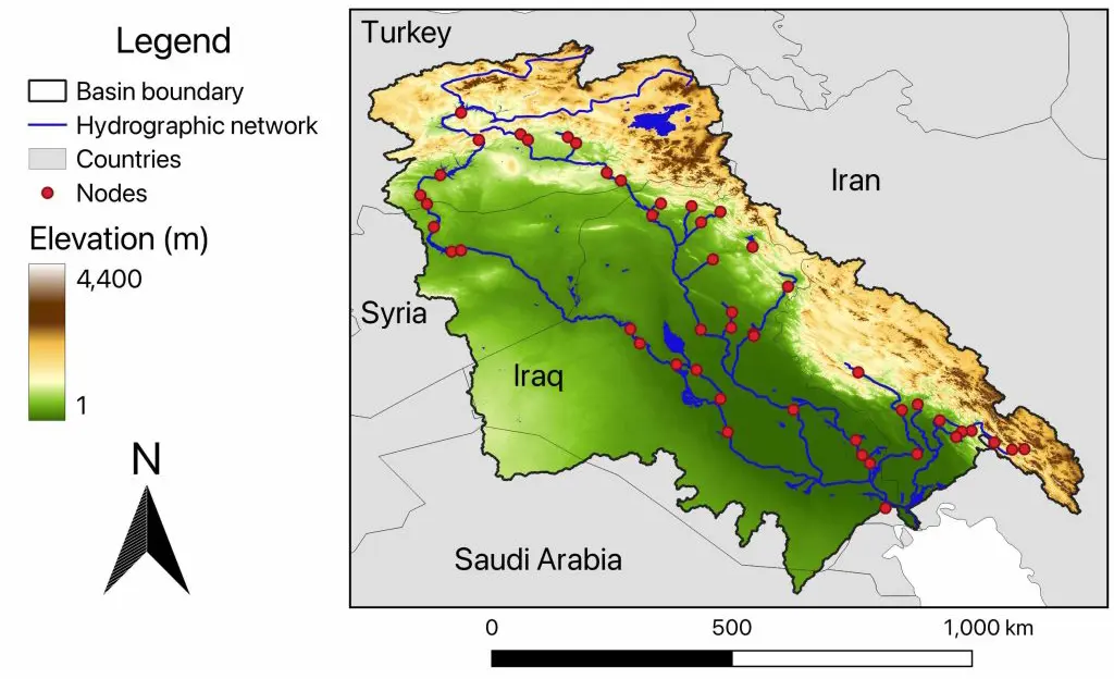
Figure 1. Euphrates River basin (URL: https://www.hydroeconomics.com/the-euphrates-tigris-river-basin/; accessed on 10 July 2026).
2. Data and Methods
2.1. Data Sources
This study synthesizes data from multiple sources, each with specific characteristics and limitations:
Hydrological Data:
-
-
USGS Hit Station data (1932–1997): Publicly available streamflow records from the United States Geological Survey gauging station at Hit, Iraq [5]. These data represent the most comprehensive long-term record for the Euphrates River and include monthly and annual means, as well as flood exceedance probabilities.
-
-
Saeed [6]: Modern flood frequency estimates for the Qaim and Hit stations (1981–2018), derived from published peer-reviewed research. Raw flow data are available upon request from the original authors.
-
-
Jones et al. (2008) [7]: SWAT model estimates of pre-dam and post-dam flow regimes and marsh area changes. These are model-based estimates rather than measured data, with inherent uncertainty.
2026 Event Data:
-
-
Official statements: Syrian Arab News Agency (SANA) reports on flood impacts, dam operations, and government responses [8,9,10,11,12,13]. SANA is the official Syrian state news agency; where cited for factual information, reports have been triangulated with independent sources where possible.
-
-
International media: AFP, tagesschau (ARD), Daily Times, The National, Kurdistan24, Shafaq News, Arabia Weather [3,14,15,16,17,18,19,20].
-
-
Satellite assessment: World Food Programme satellite-based inundation assessment [4], providing independent verification of flood extent.
-
-
Institutional data: Syrian presidential decrees (available via Syrian Memory Archive and official gazette); Syrians for Truth and Justice (STJ) NGO report on mass dismissals [21].
Limitations Acknowledgment: The 2026 flow figures (~1800–2000 m3/s) are derived from official statements rather than independently verified gauge data. No in situ gauge data from Syrian stations during the flood period are available due to conflict conditions and infrastructure damage. Satellite-derived inundation data provide independent verification of flood extent but do not directly measure discharge. These limitations are addressed in Section 11.
2.2. Analytical Framework
The analysis proceeds through four interconnected levels:
-
Hydrological analysis: Compilation and harmonization of historical flow data, calculation of return periods, and comparison of pre-dam, post-dam, and 2026 flow regimes. Cross-era comparisons are made using like-for-like metrics (monthly means with monthly means, peak flows with peak flows) with explicit notation where this is not possible.
-
Meteorological and operational analysis: Synthesis of available reports on rainfall, snowmelt, and dam operations, drawing on official statements and media reports.
-
Impact assessment: Documentation of agricultural, infrastructure, humanitarian, and ecological consequences using multiple sources.
-
Institutional analysis: Examination of documented personnel and structural changes in Syria’s water sector, framed as a hypothesis requiring testing rather than an established causal relationship.
2.3. Source Triangulation
Key data points were triangulated across multiple sources where possible. Where information is single-sourced, this is explicitly noted in the text or tables. A summary of data provenance is provided in Table 1.
Table 1. Key Data Sources and Triangulation Status.
|
Data Category |
Primary Source(s) |
Triangulation |
Notes |
|---|---|---|---|
|
Historical flows (1932–1997) |
[5] |
High confidence |
|
|
Modern flood frequency |
[6] |
[5] |
High confidence |
|
2026 peak flow |
[3] |
Not independently verified |
|
|
Flood inundation extent |
[4] |
Satellite imagery |
High confidence |
|
Dam operations |
[17] |
Single-sourced for operational details |
|
|
Impact data |
Moderate confidence |
||
|
Institutional changes |
Syrian decrees; [21] |
Syrian Memory Archive [22] |
Documented facts |
3. Historical Hydrological Context: Floods and Droughts in the Euphrates Basin
3.1. The Euphrates River Basin
The Euphrates River originates in the highlands of eastern Turkey, where approximately 90% of its flow is generated from snowmelt during late spring and early summer [23]. The river then flows through Syria and Iraq before joining the Tigris River and emptying into the Persian Gulf. Based on a signed regional agreement, Turkey agreed to release at least 500 m3/s to Syria. Syria will use only 42%, while the rest is released to Iraq [24,25]. The basin has supported human civilization for over 6000 years, with empires dependent upon irrigated agriculture flourishing and decaying along its banks [23].
3.2. Pre-Dam Flood Regime (Pre-1970s)
Before the construction of major dams on the Euphrates, the river exhibited a highly seasonal flow regime characterized by dramatic spring flooding. Almost 90% of the river’s runoff is generated within the highlands of eastern Turkey as a result of snowmelt occurring during late spring and early summer [23]. At this time, flood levels were usually reached along the whole length of the river. Until the time of the Second World War, Iraq was the only country within the Euphrates basin that made large demands on the water resources of the River [23]. The natural flow regime was characterized by high interannual variability, with flood peaks exceeding 5000 m3/s in extreme years.
3.3. Peak Flow Records 1932–1997: The USGS Dataset
The most comprehensive long-term streamflow data for the Euphrates River comes from the United States Geological Survey (USGS) gauging stations in Iraq. These records, Table 2, provide invaluable insight into the river’s historical hydrological behavior before and during the initial phases of dam construction [5].
Table 2. Monthly Extremes at Hit Station (1932–1997).
|
Month |
Maximum Discharge (m3/s) |
Year |
Minimum Discharge (m3/s) |
Year |
Mean Discharge (m3/s) |
|---|---|---|---|---|---|
|
October |
1089 |
1983 |
176 |
1993 |
395 |
|
November |
1146 |
1989 |
172 |
1989 |
498 |
|
December |
1542 |
1969 |
182 |
1990 |
616 |
|
January |
2446 |
1969 |
161 |
1990 |
695 |
|
February |
2085 |
1966 |
163 |
1990 |
755 |
|
March |
2761 |
1969 |
164 |
1993 |
998 |
|
April |
4658 |
1969 |
173 |
1990 |
1694 |
|
May |
5797 |
1969 |
166 |
1974 |
1879 |
|
June |
2711 |
1963 |
124 |
1974 |
1077 |
|
July |
1170 |
1976 |
72 |
1974 |
528 |
|
August |
986 |
1982 |
81 |
1973 |
387 |
|
September |
944 |
1982 |
89 |
1973 |
337 |
|
Annual |
2005 |
1969 |
220 |
1993 |
818 |
Data source: USGS Stream Gage Descriptions, Hit Station (IRQ_E2) [5]. Note: All values are monthly means except the “Annual” row, which shows the annual mean discharge.
The highest monthly mean discharge ever recorded at Hit was 5797 m3/s in May 1969, representing the peak of the spring snowmelt flood that year [5]. The annual mean discharge peaked in 1969 at 2005 m3/s, more than double the long-term annual mean of 818 m3/s. The lowest annual mean discharge occurred in 1993 at 220 m3/s, reflecting the severe drought conditions that affected the region during the early 1990s [5], as shown in Table 3.
Table 3. Flood Exceedance Probabilities—Hit Station (Pre-Dam Era).
|
Recurrence Interval (Years) |
3-Day Mean (m3/s) |
7-Day Mean (m3/s) |
15-Day Mean (m3/s) |
30-Day Mean (m3/s) |
|---|---|---|---|---|
|
2 |
2903 |
2732 |
2481 |
2214 |
|
5 |
4408 |
4200 |
3851 |
3441 |
|
10 |
5157 |
4945 |
4573 |
4096 |
|
20 |
5710 |
5506 |
5133 |
4608 |
|
50 |
6240 |
6052 |
5697 |
5131 |
|
100 |
6533 |
6359 |
6026 |
5440 |
Data source: USGS Stream Gage Descriptions, Hit Station (IRQ_E2) [5].
A 100-year flood event (1% annual exceedance probability) at the Hit station would produce a 3-day mean discharge of approximately 6533 m3/s [5]. The 1969 flood, with its May monthly mean of 5797 m3/s, approached but did not exceed this 100-year threshold.
3.4. The Impact of Dam Construction on Peak Flows
The construction of major dams on the Euphrates beginning in the 1960s fundamentally altered the river’s flow regime. The Keban Dam in Turkey (completed in 1974) was the first major storage project, followed by the Tabqa Dam in Syria (completed in 1973) and later the Atatürk Dam in Turkey (completed in 1990) [7]. Table 4 summarizes the impact of these dams.
Table 4. Dam Construction Impact Summary.
|
Period |
Dams Operational |
Average Monthly Peak Flow (m3/s) |
Change from Pre-Dam |
Average Annual Flow (billion m3/yr) |
Marsh Area (km2) |
|---|---|---|---|---|---|
|
Pre-1973 |
None |
6301 |
— |
80 |
~8000 |
|
1973–1989 |
Keban, Tabqa, Hamrin, Haditha, Mosul, Karakaya |
3073 |
−51% |
55 |
~6680 |
|
1990+ |
+ Atatürk |
2319 |
−63% |
50 |
~5270 |
Source: after (Jones et al., 2008). [7].
The average monthly peak flow rate decreased by 63% from the pre-dam period (6301 m3/s) to the post-Atatürk period (2319 m3/s), while average annual flow volume declined by 38% from 80 billion m3/yr to 50 billion m3/yr [7]. The areal extent of the Central and Al-Hammar marshes decreased from approximately 8000 km2 in 1966 to 5270 km2 in 1984, with a direct correlation to reduced river flows [7].
3.5. Geographic and Methodological Considerations in Cross-Era Comparisons
Direct comparison of flow data across different periods and locations requires careful attention to several factors:
Station Locations: The pre-dam baseline [7] represents basin-wide estimates, while the post-dam comparison uses measured data primarily from the Hit station in Iraq [5] and the Qaim and Husaybah stations near the Syria-Iraq border [6]. These locations are geographically distinct, with Hit located approximately 800 km downstream from the Syrian border. Flow attenuation along this reach introduces additional uncertainty.
Model vs. Measured Data: The pre-dam baseline of 6301 m3/s [7] is a SWAT model estimate rather than measured data. While calibrated against available historical records, model estimates inherently carry uncertainty. The post-dam values are measured data, subject to different types of uncertainty (rating curve changes, in-channel storage effects).
Harmonization: Direct comparison of model estimates (pre-dam) with measured data (post-dam) may introduce bias of ±10–20% in the flow reduction estimates. However, the overall pattern—a substantial (>50%) reduction in peak flows—is robust to this uncertainty. Where comparisons are made, the specific metrics are explicitly defined (monthly mean vs. monthly mean; peak flow vs. peak flow).
3.6. Flood Frequency Analysis for the Modern Period (1981–2018)
A more recent flood frequency analysis examined annual peak flow data from two Iraqi gauging stations for the period 1981–2018, providing insight into the post-dam flood regime [6], Table 5.
The study noted that “the estimated flows of all the return periods do not exceed the current average carrying capacity of the river, and this is due to the large number of dams built outside Iraq in Turkey and Syria” [6]. The post-dam 100-year flood estimates are approximately 69–77% lower than the pre-dam theoretical 100-year flood, demonstrating the extent to which upstream dams have attenuated flood peaks.
3.7. Drought History of the Euphrates Basin (1979–2020)
While this paper focuses on flooding, understanding the basin’s drought history is essential for contextualizing the 2026 flood as part of a pattern of hydrological volatility. A comprehensive multi-decadal assessment evaluated water budget and hydrological extremes in the Tigris-Euphrates Basin over four decades [1], Table 6.
Table 6. Major Drought Periods in the Euphrates Basin (1979–2020).
|
Period |
Severity |
Key Characteristics |
Water Storage Impact |
|---|---|---|---|
|
1983–1984 |
Mild to moderate |
Early 1980s dry period |
Not quantified |
|
1989–1992 |
Mild to moderate |
Extended dry conditions |
Annual mean at Hit fell to 220 m3/s (1993) |
|
1998–2000 |
Severe to exceptional |
Two-year intense drought |
Major agricultural impacts |
|
2007–2009 |
Most severe |
Largest decline in total water storage |
−80 km3 (since 1940) |
|
2011–2013 |
Mild to moderate |
Post-drought recovery |
Storage recovery begins |
|
2018 |
Mild to moderate |
Brief dry period |
Minor impact |
The 2007–2009 drought stands as the most extreme dry period in the Fertile Crescent since at least 1940 [26]. GRACE satellite data recorded a total water storage decline of −80 km3, the largest in the four-decade record, with storage depletion dominated by reservoir storage decline rather than groundwater depletion [1]. Human intervention (irrigation and groundwater abstraction) amplified storage depletion by at least 50% during the drought [1].
In a dramatic reversal, regional flooding in 2019 and 2020 produced a marked recovery in total water storage, totaling ~144 km3 by July 2020—representing approximately two times the total depletion between 2007 and 2018 [1].
3.8. The Drought-Flood Pendulum
An emerging concern highlighted by both the historical record and the 2026 event is the rapid transition from extreme drought to extreme flood conditions. As noted by analysts, “the Middle East is no longer following a ‘one-way trajectory’ of prolonged drought, but rather experiencing strong hydrological volatility, with opposing trends potentially occurring in short periods” [1]. The 2026 flood must be understood within this context: it represents the latest in a series of hydrological extremes that are testing the region’s water management infrastructure (Table 7).
Table 7. Major Flood Events on the Euphrates River (1932–2026).
|
Year |
Location |
Peak Flow (m3/s) |
Event Type |
Significance |
|---|---|---|---|---|
|
1969 |
Hit, Iraq |
5797 (monthly mean) |
Spring snowmelt |
All-time record in 65-year dataset [5] |
|
1969 |
Hit, Iraq |
2005 (annual mean) |
High flow year |
Highest annual volume on record [5] |
|
1988 |
Husaybah, Iraq |
2760 (May) |
Spring flood |
Post-dam peak [5] |
|
1988 |
Husaybah, Iraq |
1514 (annual mean) |
High flow year |
Post-dam high [5] |
|
Pre-1973 |
Mesopotamia |
~6301 |
Average peak |
Pre-dam baseline [7] |
|
2019–2020 |
Entire basin |
N/A (storage recovery) |
Flood series |
144 km3 storage gain [1] |
|
2026 |
Syria/Iraq |
~1800–2000 |
Spring snowmelt+rain |
First Euphrates Dam spill in 40 years [8] |
Note: The 2026 value is a peak release derived from official statements; it is not directly comparable to monthly means from earlier periods. Comparisons across different metrics should be made with caution.
4. Causes of the 2026 Flood Event
4.1. Meteorological Triggers
The 2026 flood resulted from two primary meteorological factors operating in concert over a period of several weeks.
Exceptional Rainfall: Large areas of Türkiye experienced severe thunderstorms and sustained heavy rainfall during May 2026, with precipitation volumes described by meteorologists as “one of the most abundant” in recent memory [18]. According to Arabia Weather, “large areas of Turkey are currently experiencing unstable weather conditions, accompanied by heavy thunderstorms in some regions, leading to rising water levels in several rivers and reservoirs” [18]. These storms affected the headwater regions of the Euphrates, where approximately 90% of the river’s flow originates [23].
Rapid Snowmelt: The Upper Euphrates Basin is characterized by snow-dominated hydrology, with winter snowpack serving as a natural reservoir [2]. Above-average winter snowfall in the Turkish highlands during the 2025–2026 winter season, combined with unseasonably warm temperatures in late spring, accelerated snowmelt rates. As reported by ARD’s Cairo correspondent, “the Turkish side informed us that an unprecedented amount of water, a flood wave, was to be expected as a result of snowmelt in Turkey and flash floods” [20].
Compound Event Structure: The simultaneous occurrence of heavy rainfall and accelerated snowmelt created what hydrologists term a “compound event”—multiple hydrological hazards coinciding to produce an effect greater than the sum of their parts [2]. This pattern is consistent with the historical behavior of the Euphrates, but the additional rainfall component made the 2026 event unusual for occurring during what is typically the harvest season rather than the peak flood season.
4.2. Dam Operations as a Causal Factor
The flood’s severity was significantly influenced by upstream dam operations, which transformed a natural high-flow event into a managed but still destructive release.
Turkish Dam Operations: Turkish authorities opened the spillway gates of the Atatürk Dam—one of the largest dams in the region and a key component of the Southeastern Anatolia Project (GAP)—for the first time in seven years [17]. According to Turkish local media quoting the regional water authority, “controlled water releases” were conducted from the Atatürk Dam after water levels rose due to heavy rainfall in recent months, with the spillway gates opened for the first time in seven years [17]. The facility had accumulated significant storage from both winter snowpack and spring rainfall, reaching maximum safe capacity.
The releases were described as necessary to maintain safe operating levels at the reservoir. As reported by the German news outlet tagesschau, “Due to the extremely high water levels at the dams in Turkey, the Turkish authorities had to release enormous amounts of water downstream in a controlled manner” [20].
Syrian Dam Operations: The Euphrates Dam (also known as the Tabqa Dam) in Syria was subsequently forced to open its floodgates for the first time in nearly four decades [8]. According to Syria’s Energy Ministry, “Syria’s dam storage capacities were almost full, necessitating the continued release of large quantities of water” [8]. Late Wednesday, May 27, the ministry posted an image showing the opening of the Euphrates Dam floodgates, stating that they had not been used for approximately 40 years, and warned people to exercise caution [8].
This cascade effect—upstream releases forcing downstream releases—amplified flood conditions along the entire stretch of the river in Syria. According to Haitham Al-Bakkour, the General Director of the Euphrates Dam, the situation was unprecedented in his experience [8].
4.3. Notification and Warning Timeline
The timeline of communications between the three riparian states was documented according to Abdul Hamid Sallat, Director of the Media Department at the Syrian Ministry of Energy, the sequence of events was as follows [9]:
Friday, May 22: Turkish authorities notified Syria of increased releases due to heavy rainfall and rising reservoir levels
Saturday, May 23 (within 24 h): Additional water reached Syrian territory; Syria notified Iraq of approximately 1000 m3/s releases, advising 4–5 days until water reaches Iraq
Tuesday, May 26: Syria informed Iraq that releases had increased to approximately 1800 m3/s due to continued inflow increases
Sunday, May 31: Turkey informed Syria that inflows would begin to decline
Sallat emphasized that “the deadline had been extremely short, since the waters had reached Syrian territory in less than 24 h after the notification, which had required urgent response measures to protect hydraulic facilities and pumping stations located along the river” [9].
4.4. Comparison with Historical Peaks
The 2026 peak flow of approximately 1800–2000 m3/s is modest compared to pre-dam floods such as the 1969 event (5797 m3/s monthly mean). However, the relative impact of the 2026 flood has been greater than many larger historical floods because of three factors: (1) changed land use—human settlement and agriculture have expanded into areas that were historically flood-prone but had been dry for decades due to flow regulation; (2) infrastructure vulnerability—decades of war and underinvestment have left water infrastructure more vulnerable to inundation [4]; and (3) timing—the flood occurred during the wheat harvest, whereas historical spring floods occurred before planting or during early growth stages [14].
5. Impacts in Syria
Syria bore the brunt of the flood’s destructive force. The most severely affected areas included Deir Ezzor and Raqqa provinces, particularly the regions surrounding Deir Ezzor city, Muhasan-Khasham, and Basira-Al Mayadin [15].
5.1. Agricultural Devastation
The timing of the flood proved catastrophic for agricultural communities. The event occurred during the wheat harvest period—the most critical time of the year for farmers who rely on a single annual crop for their livelihood [14]. The World Food Programme’s satellite-based assessment confirmed that the flood expanded the river’s surface area from 60.9 km2 to 188.7 km2, representing a threefold increase [4]. This expansion occurred along both banks of the river, affecting communities that had not experienced flooding for decades.
Farmer Testimony: A farmer interviewed by Syria TV described the sudden onset of the flood: “During the midday prayer, we noticed that the water level was rising. We immediately began to harvest. But the ears of grain were swept away by the water” [27]. Another farmer, Issa Al-Moussa, reported losing his entire 6000 square meter wheat crop, representing an investment of 1 million Syrian lira per dunam [14].
The World Food Programme’s assessment noted that the flooding poses “significant humanitarian risks, including reduced food availability, disrupted livelihoods, potential infrastructure damage, WASH concerns, and possible temporary displacement of riverine communities” [4].
5.2. Water Infrastructure Damage
The flood severely compromised water supply systems across Deir Ezzor province, creating secondary public health risks. According to the Syrian Ministry of Local Administration and Environment, emergency teams faced “unprecedented challenges” along more than 200 km of the river’s course [10]. Approximately 60 water pumping stations were rendered inoperative in the Shamiyah and Jazira regions due to rising water levels [10]. The remaining outages left tens of thousands of residents without access to potable water, raising significant Water, Sanitation, and Hygiene (WASH) concerns [4].
5.3. Transportation Disruptions
Three major earthen bridges connecting the eastern and western banks of the Euphrates collapsed or were rendered unusable during the flood event. According to reports from affected areas, “floodwaters submerged an earthen bridge and disrupted transportation routes connecting nearby communities and rural areas already struggling with infrastructure challenges” [15]. Residents reported being forced to use small boats to cross between riverbanks—a dangerous undertaking given the strong currents and continued high flows [3], Table 8.
Table 8. Bridge Damage Summary.
|
Location |
Bridge Type |
Status |
Consequence |
|---|---|---|---|
|
Deir Ezzor province (multiple) |
Earthen bridges |
Collapsed |
Cross-river traffic impossible [15] |
|
Al-Mayadeen area |
Earthen bridge |
Collapsed |
Ferry operations suspended [15] |
|
Al-Asharah area |
Earthen bridge |
Collapsed |
Alternative routes required [15] |
|
Maadan, Raqqa province |
Earthen bridge |
Closed (structural cracks) |
Precautionary closure [10] |
5.4. Humanitarian Impact
Fatalities: At least five deaths were reported, including four children and one adult. According to German news outlet tagesschau, “Four children and a man are said to have been swept away by the strong currents of the Euphrates in recent days and drowned” [20].
Affected Population: Approximately 2400 families were directly affected by flooding in Deir Ezzor province [4]. Some residents reported being forced to evacuate with only the clothes they were wearing, leaving behind vehicles, livestock, and belongings [14].
Displacement: Evacuation operations were conducted in threatened areas, including Al-Houeiqa, Houeijat Saqr, and Qataa, where two reception centers were prepared in local schools to accommodate displaced families [10].
Internally Displaced Persons (IDPs): The flooding also severely affected internally displaced persons from Syria’s long-running civil war who lived in tent settlements along the river. One displaced woman, Umm Warda, described the experience: “The water came towards us, it rose and rose. I fled to our neighbour’s house and slept there. Early in the morning, I came back here”. When she returned, only the bare frame of her tent remained standing [20].
Medical Access: The Emergency Response Committee documented 36 ambulance transfers of patients between the two banks of the Euphrates River, highlighting the critical nature of transportation disruptions for healthcare access [10].
5.5. Government Response
The crisis prompted an unprecedented high-level response from the Syrian transitional government. President Ahmad Al-Charaa personally visited Deir Ezzor province with a high-level ministerial delegation to assess damage and coordinate response efforts [11].
Emergency measures included [11]:
Crisis management: Establishment of a joint crisis cell combining efforts from Raqqa and Deir Ezzor governorates with the Ministry of Water Resources
Personnel deployment: Reinforcement teams dispatched from Aleppo, Idleb, Hama, and Homs provinces
Food security intervention: 1050 tons of flour dispatched to Deir Ezzor to maintain bread production
Humanitarian aid: A convoy of 11 trucks delivered supplies through the Syrian Arab Red Crescent in cooperation with the International Federation of Red Cross and Red Crescent Societies
5.6. Ecological and Environmental Consequences
The 2026 flood had significant ecological implications for the Euphrates riverine system and the downstream Mesopotamian marshes.
Riverine and Floodplain Habitat: The threefold expansion of the river’s surface area (from 60.9 km2 to 188.7 km2) inundated extensive riparian and floodplain habitats [4]. While floodplain inundation can provide ecological benefits through sediment deposition and nutrient cycling, the timing—during the late spring growing season—may have disrupted breeding and nesting cycles for riverine species. The sudden inundation of areas that had been dry for decades (due to flow regulation and drought) likely caused both ecological disruption (through habitat loss for terrestrial species) and potential benefits (through wetland restoration).
Mesopotamian Marshes: The Central and Al-Hammar marshes, which had contracted from approximately 8000 km2 in 1966 to 5270 km2 in 1984 due to reduced flows [7] , represent one of the world’s most important wetland ecosystems. The 2019–2020 floods produced a marked recovery in total water storage (~144 km3), contributing to marsh expansion [1]. The 2026 flood, while smaller in magnitude than the 2019–2020 events, likely provided additional inflows to these marshes. However, the timing and water quality of the flood (sediment-laden flows potentially carrying pollutants from agricultural and urban areas) are uncertain.
Water Quality Concerns: The inundation of agricultural areas—including fields that had recently been treated with fertilizers and pesticides—raised concerns about nutrient and contaminant loading into the river system [4]. The loss of 60 water pumping stations also created public health risks from untreated sewage and disrupted the water supply.
Potential Positive Effects: Historical flood regimes on the Euphrates provided important ecosystem services, including sediment deposition, nutrient cycling, groundwater recharge, and maintenance of riparian vegetation. The 2026 flood, while destructive to human communities, may have contributed to these ecological functions in a river system that has been flow-regulated for decades.
6. Impacts and Response in Iraq
6.1. A Contrasting Scenario
While Syria experienced destructive flooding, Iraq’s situation proved markedly different. The same water inflows that caused devastation in eastern Syria reached Iraq as a manageable—and potentially beneficial—hydrological event [19].
Preparedness: Iraqi authorities, having received advance notification from Syrian officials on Saturday, had approximately 4–5 days to prepare [9]. The Anbar provincial council declared a “state of full alert for 72 h, warning of an upcoming wave of torrents and devastating floods coming from the Syrian border through the town of Al Qaim” [16].
Storage Capacity: According to Turhan Al-Mufti, advisor to the Iraqi prime minister on water affairs, the country possesses “irrigation systems capable of absorbing any volumes arriving through the Euphrates without causing floods” [19]. He explained that Haditha Lake has significant unused storage capacity, while Habbaniyah and Razaza lakes provide additional storage reserves. Excess water can also be diverted to the Tharthar Depression, and if those systems reach capacity, water can be directed to the marshlands [19].
Tahseen Al-Moussawi, an Iraqi water expert, described the Haditha Dam as Iraq’s “first line of defense”, noting that it has a storage capacity exceeding 10 billion cubic meters, while its current storage does not exceed 2 billion cubic meters [19].
6.2. Strategic Opportunity
Water experts characterized the incoming flows as a “rare opportunity” for Iraq to replenish its strategic water reserves following years of drought and declining upstream flows (Shafaq News, 2026). The country had been experiencing one of its most severe drought periods, with water inflows dropping during dry years to low levels [1].
Al-Mufti emphasized that “this year is a wet year, not a flood year”, stressing that Iraq can absorb “any quantity, regardless of size”, with surplus water potentially directed toward the marshes to support the ecosystem [19]. According to Turhan Al-Mufti, advisor to the Iraqi prime minister on water affairs, Iraq needs 20 billion cubic meters of water annually, and he stated that around 17 billion cubic meters were expected to arrive from Syria in the coming days [19]. However, this figure appears implausible based on simple flow calculations: at the stated peak release of 1800 m3/s (~0.16 km3/day), 17 billion cubic meters would require approximately 109 days of sustained peak flow. The statement is therefore treated here as an expert opinion reflecting optimistic expectations for water storage replenishment rather than a precise quantitative forecast.
6.3. Limited Localized Impacts
Despite the overall manageable situation, some localized impacts were recorded in Anbar province [16]:
Three bridges were taken out of service
The Saada water project temporarily suspended operations due to elevated water levels
Some roads were submerged, affecting local transportation
These impacts, however, were minor compared to the widespread devastation in Syria.
7. Transboundary Coordination Analysis
7.1. Notification System Strengths and Weaknesses
The flood event exposed both the existence and the significant weaknesses of transboundary water communication mechanisms among the three riparian states.
Türkiye-Syria Communication: The Turkish authorities did provide notification to Syria of increased releases. However, Syrian Energy Minister Mohammad Al-Bashir stated that “Türkiye’s warning to us about the rising water levels of the Euphrates River came too late” [3]. According to detailed Syrian accounts, the notification arrived on a Friday, and the water reached Syrian territory in less than 24 h [9]. This timeline proved inadequate to implement protective measures for water pumping stations, evacuate vulnerable populations, or harvest at-risk wheat crops before inundation.
Syria-Iraq Communication: In contrast to the Türkiye-Syria channel, coordination between Syria and Iraq functioned relatively effectively. Syrian authorities provided Iraqi officials with technical data on expected flow volumes and timelines in two separate notifications, providing approximately 4–5 days of advance warning—sufficient for Iraq to prepare its reservoirs and implement protective measures [9].
7.2. Turkish Perspective
Notably, no official Turkish position was issued regarding the extent of coordination with Syria during the event. Turkish media quoted official sources from the State Hydraulic Works indicating that “controlled water releases” were conducted from the Atatürk Dam after water levels rose due to heavy rainfall, with spillway gates opened for the first time in seven years [17]. However, the operational decision-making process—including whether downstream impacts were adequately considered in release calculations—remains unclear from public sources.
The Syrian government maintained ongoing technical communication with Turkish authorities throughout the event. According to Sallat, “in recent days, communication and technical coordination with the Turkish side continued to monitor the evolution of water inflows. Ankara informed Damascus that incoming flows would begin to decrease from Sunday evening, which would gradually result in a reduction in water volumes released by the Euphrates Dam” [9].
A full understanding of the Turkish perspective would require access to internal operational documents and interviews with DSİ officials—data not available for this study.
7.3. Broader Governance Context
The 2026 flood must be understood within the broader context of transboundary water governance in the Tigris-Euphrates basin. As noted by Beaumont [23], “the only permanent solution to the problem would seem to be the establishment of an international body to supervise the just allocation of the water resources of the Euphrates between Turkey, Syria, and Iraq”. Nearly five decades later, such a body has yet to be established.
The fundamental legal and geographical differences between Turkish, Syrian, and Iraqi water management schools continue to complicate cooperation [28]. Türkiye historically favors the concept of “transboundary rivers”, emphasizing sovereign rights, while downstream Syria and Iraq advocate for “international rivers” with shared governance—a dichotomy that remains unresolved [28].
8. Syria-Iraq Outcome Divergence: A Comparative Analysis
8.1. Factors Contributing to Divergent Outcomes
The Syria-Iraq comparison reveals multiple factors contributing to the divergent outcomes, as summarized in Table 9.
Table 9. Factors Contributing to Divergent Syria-Iraq Outcomes.
|
Factor |
Syria |
Iraq |
Relative Contribution to Outcome |
|---|---|---|---|
|
Warning lead time |
<24 h (from Turkey) |
4–5 days (from Syria) |
High |
|
Reservoir storage capacity |
Full (~100% of capacity) |
Abundant (~20% of capacity) |
High |
|
Infrastructure condition |
War-damaged, under-maintained |
Functional, maintained |
Medium-High |
|
Institutional capacity |
Disrupted (post-2024 transition) |
Stable |
Medium (hypothesis) |
|
Land use in floodplain |
High (agricultural expansion) |
Managed |
Medium |
|
River geomorphology |
Constrained, high velocity |
More storage options |
Medium |
|
Economic resources for response |
Limited |
Significant |
Medium |
The relative magnitude of the institutional factor cannot be quantified with available data. The institutional hypothesis is discussed in Section 9.
8.2. Challenges in Isolating Institutional Effects
Multiple interacting factors complicate the Syria-Iraq comparison. Iraq’s better outcome cannot be attributed solely to institutional stability; the following factors also contributed:
-
Geographic position: Iraq is downstream of Syria, providing more time to prepare
-
Reservoir capacity: Iraq’s Haditha Lake had substantial unused storage (10 billion m3 capacity, 2 billion m3 current storage)
-
Infrastructure investment: Iraq’s water infrastructure received more investment in recent decades
-
Warning time: Iraq received 4–5 days warning from Syria, while Syria received <24 h from Turkey
These factors suggest that Iraq’s favorable outcome was overdetermined—multiple factors contributed simultaneously. The institutional hypothesis for Syria requires further investigation with primary data.
9. Institutional Instability in Syria’s Water Sector: A Hypothesis for Further Investigation
9.1. Documented Institutional Changes
Beyond the immediate transboundary coordination failures, some observers have attributed the severity of the 2026 flood to institutional disruptions within Syria’s water management apparatus following the political transition in late December 2024. This section documents what is known and frames this as a hypothesis requiring further investigation.
First, the new administration formally dissolved the Ministry of Water Resources on 29 March 2025, merging it with the Ministry of Electricity and the Ministry of Oil and Mineral Resources to create a consolidated Ministry of Energy [29]. This restructuring eliminated a dedicated ministerial entity focused exclusively on water resources management.
Second, the transitional government implemented a series of personnel changes affecting senior water sector positions. On 1 June 2025, President Ahmad Al-Sharaa issued three decrees (Nos. 32, 33, and 36) appointing new deputies to the Minister of Energy. Decree No. 36 specifically appointed Osama Khalid Abu Zeid as Deputy Minister of Energy for Water Resources Affairs [12]. This appointment occurred at the onset of the spring flood season—a critical period for water management.
Third, subsequent decrees issued in October 2025 cancelled the appointments of two senior water infrastructure experts. Decree No. 198 of 2025 annulled the assignment of Eng. Hamdi Imad al-Din Ibrahim al-Fattal as Deputy Minister of Water Resources for Infrastructure Affairs—a position he had held since 2021 [22,30,31]. Decree No. 200 of 2025 similarly annulled the assignment of Eng. Jihad Munir Kanaan as Deputy Minister of Water Resources for Water Strategy [13,32,33]. Both engineers had been appointed during the previous administration based on technical qualifications and held responsibilities directly relevant to dam safety, water infrastructure, and flood management.
Fourth, a comprehensive investigation by the Syrian non-governmental organization Syrians for Truth and Justice (STJ), published in May 2025, documented mass dismissal campaigns targeting thousands of public sector employees across various ministries following the regime change. The report noted that the caretaker government adopted “arbitrary, summary, and improvised measures that resulted in the termination of thousands of public employees” as part of a plan reportedly aimed at dismissing over 300,000 workers [21]. The dismissals extended “across key sectors such as energy, water, telecommunications, local administration, and the Ministries of Agriculture, Justice, and Health” [21]. Crucially, the report concluded that “the relevant ministries and administrative bodies rushed to issue executive decisions, including nominal lists of dismissed employees, just days after the government decision was announced”, raising “serious questions about whether sufficient time was allocated for preparation and verification of the names of those affected” [21]. The STJ report also documented that employees facing dismissal were pressured to sign “release requests” and that some had not received legally mandated compensation at the time of the investigation [21].
9.2. The Hypothesis: Institutional Instability as a Contributing Factor
These personnel changes, occurring in rapid succession between June and October 2025, suggest a significant disruption in technical continuity within Syria’s water management institutions during a period when operational expertise was most needed. The dismissal of experienced engineers holding portfolios directly related to water infrastructure and strategy, combined with the elimination of the dedicated Ministry of Water Resources, raises legitimate questions about institutional capacity to respond to extreme hydrological events. However, the following critical limitations must be acknowledged:
It is important to note that the flooding’s primary causes—extreme rainfall, rapid snowmelt, and upstream dam releases—were natural and operational in origin, and no direct evidence has emerged linking specific personnel changes to particular flood management failures during the May–June 2026 event. The documented institutional instability preceding the flood, including the mass dismissal campaigns documented by [21] and the cancellation of senior technical appointments [12,13,22], may have affected Syria’s capacity to maintain, operate, and respond with its water infrastructure during a crisis. However, this remains a hypothesis requiring further investigation with primary data on operational capacity and response times.
This hypothesis requires testing through:
-
Operational data on dam and pumping station management before and after the personnel changes
-
Before/after comparisons of response times to hydrological warnings
-
Counterfactual analysis of what would have occurred with the previous management team
-
Interviews with former and current water sector personnel
These data are not currently available for this study.
9.3. Timeline of Institutional Changes
Table 10 provides a timeline of documented institutional changes relative to the flood event.
Table 10. Timeline of Institutional Changes and the 2026 Flood.
|
Date |
Event |
Documentation |
|---|---|---|
|
December 2024 |
Political transition in Syria |
Multiple sources |
|
29 March 2025 |
Ministry of Water Resources dissolved |
[29] |
|
May 2025 |
STJ report on mass dismissals published |
[21] |
|
1 June 2025 |
Decree Nos. 32, 33, 36 (new appointments) |
[12] |
|
October 2025 |
Decree Nos. 198, 200 (appointments annulled) |
|
|
May–June 2026 |
Flood event |
This study |
Note: This timeline establishes temporal proximity but does not establish causation.
10. Discussion
10.1. The 2026 Flood in Historical Context
The 2026 Euphrates flood, with peak flows of approximately 1800–2000 m3/s, represents a moderate flood by historical standards but a severe event in the post-dam era. Table 11 compares the 2026 flooding with its proper historical perspective.
Table 11. The 2026 Flood in Historical and Regional Context.
|
Aspect |
Pre-Dam Era (Pre-1973) |
1969 Record Flood |
Post-Dam Era (1990+) |
2026 Event |
|---|---|---|---|---|
|
Peak flow (m3/s) |
~6300 (avg monthly peak) |
5797 (May mean) |
~1000–1500 |
~1800–2000 |
|
100-year flood est. (m3/s) |
~6500 |
— |
1480–2030 |
N/A |
|
Return period |
N/A |
~20–50 years |
~5–10 years |
~5–10 years |
|
Primary cause |
Snowmelt |
Snowmelt |
Dam operations |
Snowmelt + rain + dams |
|
Euphrates Dam spill |
Frequent |
Yes |
None (40 years) |
Yes |
|
Agricultural impact |
Seasonal |
Severe |
Limited |
Severe (harvest timing) |
The 2026 event is statistically consistent with a 5–10 year return period flood in the modern, dam-regulated flow regime [6]. The fact that such a relatively modest event caused extensive damage reflects: (1) reduced adaptive capacity due to years of conflict and economic hardship in Syria; (2) infrastructure deterioration of water pumping stations, bridges, and early warning systems; (3) land use changes that have placed more assets in flood-prone areas; and (4) the timing of the event coinciding with the wheat harvest [4,14].
10.2. Climate Change Implications: The Drought-Flood Pendulum
The 2026 flood fits within broader patterns of hydrological intensification associated with climate change. [1] concluded that “prolonged droughts are the norm rather than the exception in the TEB over the past four decades”. However, the same study documented that severe droughts are being punctuated by intense flood events—such as the 2019–2020 floods that produced ~144 km3 of water storage recovery (double the 2007–2018 depletion).
The 2026 event continues this pattern. The basin experienced severe drought conditions as recently as 2018, followed by the 2019–2020 floods, then a return to below-average conditions, and now the 2026 flood [1]. This “drought-flood pendulum” presents particular challenges for water management institutions designed for stationary hydrological conditions.
Climate change projections for the eastern Mediterranean region indicate increased hydrological volatility, with more frequent and severe droughts likely to alternate with more intense flood events [1,2]. However, the magnitude of these changes remains uncertain, and ongoing dam operations will continue to attenuate flood peaks relative to pre-dam conditions. The 2026 event is consistent with these projections but cannot be directly attributed to climate change without formal attribution analysis.
10.3. Implications for Water Management
Reservoir Operations: The event demonstrates that dam operators face difficult trade-offs between water storage for dry periods and flood control during extreme events. The Atatürk Dam’s release, while necessary for dam safety, contributed to downstream flooding. Clear protocols that account for transboundary impacts could help optimize these trade-offs.
Infrastructure Design: The flood suggests that design standards for water, transportation, and energy infrastructure along the Euphrates may need updating. The fact that 60 pumping stations were rendered inoperative indicates that even moderate floods exceed current design tolerances [10].
Early Warning Systems: The inadequate notification time for Syria (less than 24 h) indicates a need for improved early warning systems with guaranteed minimum lead times for downstream states [9]. The effective Syria-Iraq coordination (4–5 days) demonstrates what is possible with adequate warning.
Regional Cooperation: The contrast between the Türkiye-Syria and Syria-Iraq coordination demonstrates that effective cooperation is possible, even in the absence of comprehensive basin-wide agreements. Building on this demonstrated capacity could form the basis for improved regional mechanisms.
11. Limitations and Future Research Needs
11.1. Data Limitations
This study is subject to several important data limitations:
-
Unverified 2026 flow figures: The 2026 flow estimates (~1800–2000 m3/s) are derived from official statements and media reports. No independently verified gauge data from Syrian stations during the flood period are available due to conflict conditions and infrastructure damage.
-
No hydraulic modeling: This paper does not include hydraulic modeling of the flood wave propagation. Such modeling would require detailed bathymetric data, cross-sectional information, and calibrated hydraulic models, which are not available for the Syrian portion of the Euphrates.
-
No formal attribution analysis: While the flood is consistent with climate change projections for the region, we do not claim direct causation. Formal attribution analysis would require climate modeling that is beyond this paper’s scope.
-
Incomplete Turkish operational data: The Turkish perspective relies on publicly available sources; internal operational documents and decision-making processes remain inaccessible.
-
Institutional data limitations: The institutional analysis relies on documented decrees and NGO reports. Primary data on operational capacity (e.g., response times, maintenance records, staff competencies) are not available.
11.2. Future Research Priorities
Based on these limitations, the following research priorities are identified:
-
Primary data collection: When conditions permit, collection and analysis of in situ gauge data from Syrian stations during the 2026 flood
-
Hydraulic modeling: Development of a calibrated hydraulic model for the Syrian Euphrates reach to analyze flood wave propagation and inundation patterns
-
Institutional analysis: Systematic assessment of Syria’s water management capacity before and after the 2024 transition, including operational metrics and staff competencies
-
Climate attribution: Formal climate change attribution analysis for the 2026 flood event
-
Comparative flood impact analysis: Quantitative comparison of the 2026 flood impacts with previous floods (e.g., 1988) using consistent methodologies
12. Recommendations
Based on this analysis, including the historical context of flooding and drought in the Euphrates basin, the following recommendations are proposed.
12.1. For Transboundary Water Management
Establish minimum notification protocols of at least 72 h for significant flow changes. The Syrian experience of less than 24 h’ warning is demonstrably inadequate [9].
Create a shared hydrological data platform providing real-time access to reservoir levels, release rates, and downstream flow measurements, potentially supported by UN agencies such as ESCWA.
Develop coordinated reservoir operation guidelines establishing technical protocols for extreme events, including pre-defined release trigger levels and notification requirements. Given the “drought-flood pendulum” pattern [1], these protocols should address both hydrological extremes.
Build on successful bilateral channels as demonstrated by the effective Syria-Iraq coordination during this event [9].
12.2. Hypothesis-Based Institutional Recommendations
The following recommendations are conditional on further investigation confirming the institutional hypothesis. They are presented as potential measures to consider if the hypothesis is supported by future research.
If the institutional hypothesis is confirmed, the following measures would be warranted:
-
-
Reconstitute the Ministry of Water Resources as a standalone technical agency. The dissolution of the ministry on 29 March 2025 eliminated dedicated oversight of water infrastructure at a critical time [29]. A reestablished ministry should be insulated from political appointments and staffed primarily by career hydrologists, engineers, and water managers.
-
-
Reverse mass dismissals of technical water sector personnel. The mass dismissal campaigns documented by STJ [21] removed thousands of experienced employees from the water and energy sectors. Priority should be given to reinstating senior engineers whose appointments were cancelled by Decrees Nos: 198 and 200 of 2025 [13,22].
-
-
Establish an emergency technical working group for dam safety and flood forecasting. Given that the management team at the Ministry of Energy and Water has been replaced and many skilled workers remain abroad awaiting stable conditions, an interim technical body comprising both current staff and exiled experts should be formed to ensure operational continuity during the transition period.
-
-
Depoliticize water sector appointments. A formal qualification framework should be established, requiring relevant engineering or hydrological credentials for all senior water infrastructure posts.
12.3. For Infrastructure Resilience
Conduct flood vulnerability assessments systematically evaluating critical water, energy, and transportation infrastructure along the Euphrates. The fragility of war-damaged infrastructure in Syria requires particular attention [4].
Update design standards for new infrastructure to account for non-stationary hydrological conditions. The 100-year flood estimates from the pre-dam era (6533 m3/s) are no longer relevant; however, post-dam estimates (1480–2030 m3/s) may also be underestimates if climate change increases flood frequency [2,6].
12.4. For Early Warning and Community Preparedness
Establish community-based early warning systems that reach at-risk farming communities with sufficient lead time to harvest crops and evacuate. The current system proved insufficient for agricultural protection [14].
Create strategic grain reserves given the vulnerability of wheat harvests to timing-sensitive floods—exacerbated by the region’s drought-flood volatility [1].
12.5. For Climate Adaptation
Incorporate climate projections into flood frequency analyses for Euphrates basin infrastructure using climate model projections rather than historical data alone [2].
Develop integrated drought-flood management protocols recognizing that the same infrastructure and institutions must manage both water scarcity and flood risks. The experience of the 2007–2009 drought (80 km3 storage decline), followed by the 2019–2020 floods (144 km3 recovery) and then the 2026 flood, demonstrates the need for flexible management approaches [1].
12.6. For International Cooperation
Revisit water sharing agreements as the fundamental challenge identified by Beaumont [23]—the absence of an international body to supervise water allocation—remains unresolved. The 2026 flood demonstrates that cooperation is possible on an ad-hoc basis, but a permanent framework is needed.
Establish a joint scientific committee comprising hydrologists, climate scientists, and water managers from all three riparian states to develop shared flood frequency analyses and climate projections. The USGS dataset (1932–1997) and the more recent Qaim and Hit records provide a shared baseline for such work [5,6].
Provide international technical assistance for the reconstruction of Syria’s water sector. Given the institutional changes documented in Section 9—including the dissolution of the Ministry of Water Resources, the dismissal of technical staff, and the cancellation of senior engineering appointments—international partners (UN, World Bank, EU) should consider supporting the rebuilding of Syria’s water management capacity if the institutional hypothesis is confirmed by further investigation. Such support would be a precondition for future flood resilience in the event that institutional capacity is found to be a critical factor.
13. Conclusions
The Euphrates River flood of May–June 2026 represents a significant hydrological event that must be understood within the broader context of the river’s history, the region’s climate volatility, and—as a hypothesis warranting further investigation—the potential institutional fragility of Syria’s water management sector following the 2024 political transition.
While the peak flow of approximately 1800–2000 m3/s is modest compared to pre-dam floods such as the 5797 m3/s recorded at Hit in May 1969 [5], it is consistent with a 5–10 year return period event in the modern, dam-regulated flow regime [6]. The fact that such a relatively moderate flood caused extensive damage in Syria—while neighboring Iraq managed the same inflows as a strategic opportunity—reflects a combination of physical, operational, and institutional factors.
The flood’s impacts were distributed asymmetrically: Syria experienced widespread devastation to agriculture, water supply, and transportation infrastructure, including at least five confirmed fatalities and thousands of displaced families [4,20]. Iraq, by contrast, managed the inflow as an opportunity for strategic water storage, capitalizing on its substantial reservoir capacity and the 4–5 days of advance warning provided by Syrian authorities (Shafaq News, 2026; [9,19].
The historical record reveals several important patterns. First, dam construction reduced average monthly peak flows by 63% and eliminated the most extreme flood events [7]. Second, the basin has experienced “prolonged droughts as the norm rather than the exception” over the past four decades [1]. Third, these droughts have been punctuated by intense flood events, including the 2019–2020 floods that produced 144 km3 of storage recovery—double the previous depletion [1].
The 2026 flood continues this pattern of hydrological volatility. Its causes were both natural (extreme rainfall and snowmelt) and operational (dam releases), demonstrating the complex interactions between climate variability and infrastructure management in transboundary river basins [17,18]. The inadequate notification time between Turkey and Syria (less than 24 h) contrasts sharply with the effective coordination between Syria and Iraq (4–5 days), highlighting the need for improved transboundary communication protocols [9].
This paper has also identified a critical and previously underappreciated factor that warrants further investigation: the institutional destabilization of Syria’s water sector following the December 2024 political transition. The dissolution of the Ministry of Water Resources [29], mass dismissals of technical staff [21], and cancellation of senior engineering appointments [13,22] may have compromised Syria’s capacity to maintain infrastructure, respond to warnings, and mitigate flood damage. However, no direct evidence links specific personnel changes to particular flood management failures. The cumulative effect of these disruptions—occurring in rapid succession between June and October 2025—created an institutional environment that may have been ill-prepared for an extreme hydrological event. This remains a hypothesis that requires further investigation using primary data.
As climate change continues to alter hydrological regimes across the eastern Mediterranean, the Euphrates basin will likely experience both more severe droughts and more extreme flood events—though the latter will remain attenuated by upstream dams [1,2]. The 2026 flood should serve as a catalyst for a dual-track response: strengthening regional cooperation and transboundary early warning systems, while also—if the institutional hypothesis is confirmed—rebuilding Syria’s domestic water management capacity. Without the latter, even the most robust transboundary protocols will fail to protect vulnerable communities on the ground.
Whether the basin’s riparian states can overcome their historical differences to build cooperative systems—and whether Syria can reconstitute its technical water sector—remains an open question. The answer holds profound implications for the millions who depend on the waters of the Euphrates, just as it has for the past six millennia [23].
Statement of the Use of Generative AI and AI-Assisted Technologies in the Writing Process
During the preparation of this manuscript, the author(s) used Grammarly and ChatGPT in order to refine language and improve grammar. After using these tools, the author(s) reviewed and edited the content as needed and take(s) full responsibility for the content of the published article.
Acknowledgments
The author thanks the Center for Sustainable Visions, Lund, Sweden, for its support during the preparation of this chapter. The author acknowledges the contributions of the Syrian Arab News Agency, the World Food Programme, Oxfam, the International Federation of Red Cross and Red Crescent Societies, and other organizations that provided data and analysis on the 2026 Euphrates flood. The author also thanks the many Syrian and Iraqi water experts, farmers, and affected communities who shared their experiences and insights.
Ethics Statement
Not applicable for studies not involving humans or animals.
Informed Consent Statement
Not applicable for studies not involving humans.
Data Availability Statement
All data presented in this study are available in the cited references and public sources. The 2026 flow figures are derived from official statements and media reports, as detailed in the text. The USGS Hit Station data are publicly available.
Funding
This research received no external funding. The author used his own time to develop and publish this work.
Declaration of Competing Interest
The author declares that he has no known competing financial interests or personal relationships that could have appeared to influence the work reported in this paper.
References
-
Rateb A, Scanlon BR, Kuo C-Y. Multi-decadal assessment of water budget and hydrological extremes in the Tigris-Euphrates Basin using satellites, modeling, and in-situ data. J. Hydrol. 2021, 598, 144337. DOI:10.1016/j.scitotenv.2020.144337 [Google Scholar]
-
Uysal G, Dogan YO, Civelek HS, Sorman AA, Sensoy A. Analyzing the Effects of Climate Change for the Water Tower of Mesopotamia, Türkiye. Proc. IAHS 2024, 385, 465–470. DOI:10.5194/piahs-385-465-2024 [Google Scholar]
-
AFP (Agence France-Presse). Flooding in North and East Syria as Euphrates Level Rises; Daily Mail; Agence France-Presse: Paris, France, 2026. [Google Scholar]
-
WFP (World Food Programme). WFP Satellite-Based Assessment of Euphrates River Flooding—Syrian Arab Republic; ReliefWeb; World Food Programme: Rome, Italy, 2026. [Google Scholar]
-
USGS (United States Geological Survey). Stream Gage Descriptions and Streamflow Statistics for Sites in the Tigris River and Euphrates River Basins, Iraq. In USGS Data Series 540; USGS: Reston, VA, USA, 2010. [Google Scholar]
-
Saeed SF, Mustafa AS, Al Aukidy M. Assessment of Flood Frequency Using Maximum Flow Records for the Euphrates River, Iraq. IOP Conf. Ser. Mater. Sci. Eng. 2021, 1076, 012111. DOI:10.1088/1757-899X/1076/1/012111 [Google Scholar]
-
Jones C, Sultan M, Yan E, Milewski A, Hussein M, Al-Dousari A, Al-Kaisy S, Becker R. Hydrologic impacts of engineering projects on the Tigris–Euphrates system and its marshlands. J. Hydrol. 2008, 353, 59–75. DOI:10.1016/j.jhydrol.2008.01.029 [Google Scholar]
-
SANA (Syrian Arab News Agency). Euphrates Dam Floodgates Opened for First Time in 40 Years; SANA: Damascus, Syria, 2026. [Google Scholar]
-
SANA (Syrian Arab News Agency). Damas détaille la coordination syro-turco irakienne sur les lâchers d'eau de l'Euphrate; SANA: Damascus, Syria, 2026. [Google Scholar]
-
[SANA (Syrian Arab News Agency). Euphrates Floods Damage 21,853 Dunams of Farmland in Deir Ezzor; SANA: Damascus, Syria, 2026. [Google Scholar]
-
SANA (Syrian Arab News Agency). President Al-Charaa Visits Deir Ezzor to Assess Flood Damage; SANA: Damascus, Syria, 2026. [Google Scholar]
-
Al-Ikhbariya al-Suriyya. Presidential Decree Appointing Osama Abu Zeid as Deputy Minister of Energy for Water Resources; Al-Ikhbariya al-Suriyya: Damascus, Syria, 2025. [Google Scholar]
-
SANA (Syrian Arab News Agency). Presidential Decree Annulling the Assignment of Deputy Minister of Water Resources to Jihad Kanaan; SANA: Damascus, Syria, 2025. [Google Scholar]
-
AFP (Agence France-Presse). Euphrates Flood Deprives East Syria Farmers from Crops; Kuwait Times: Shuwaikh, Kuwait, 2026. [Google Scholar]
-
Ali HS. English News Rising Euphrates Floods Farmland, Forcing Families to Flee in Eastern Syria. 30 May 2026. Available online: https://english.news.cn/20260530/71e581f44dfa404ca92e8bee958cf27e/c.html (accessed on 15 July 2026).
-
The National. Flood Alerts in Syria and Iraq after Heavy Rainfall and Water Releases by Turkey; The National: Abu Dhabi, United Arab Emirates, 2026. [Google Scholar]
-
Kurdistan24. Water Levels in Iraq's Euphrates Rise Following Dam Release in Türkiye; Kurdistan24: Erbil, Iraqi, 2026. Available online: https://www.kurdistan24.net (accessed on 15 July 2026).
-
Arabia Weather. The Land of a Thousand Dams: Severe Thunderstorms Hit Türkiye... Will the Risk of Flooding the Euphrates River Increase? Arabia Weather: Amman, Jordan, 2026. Available online: https://www.arabiaweather.com (accessed on 15 July 2026).
-
Shafaq News. Euphrates Flood Wave Approaches Iraq: Water Lifeline or Emerging Threat? Shafaq News: Baghdad, Iraq, 2026. Available online: https://shafaq.com (accessed on 15 July 2026).
-
Tagesschau (ARD). Syrien: Euphrat-Hochwasser sorgt für Überschwemmungen; ARD: Hamburg, Germany, 2026. [Google Scholar]
-
STJ (Syrians for Truth and Justice). Annual Report: Mass Dismissals in Syria After the Regime's Fall; STJ: Paris, France, 2025. Available online: https://stj-sy.org/en/annual-report-2025/ (accessed on 15 July 2026).
-
Syrian Memory Archive. Presidential Decree No. 198 of 2025: Annulling the Assignment of the Position of Deputy Minister of Water Resources to Hamdi al-Fattal. 29 September 2025. Available online: https://www.syrianmemory.org (accessed on 15 July 2026).
-
Beaumont P. The Euphrates River—An International Problem of Water Resources Development. Environ. Conserv. 1978, 5, 35–43. DOI:10.1017/S0376892900005257 [Google Scholar]
-
Mourad KA, Berndtsson R. Syrian water resources between the present and the future. Air Soil Water Res. 2011, 4, 93–100. DOI:10.4137/ASWR.S80 [Google Scholar]
-
Mourad KA, Alshihabi O. Assessment of future Syrian water resources supply and demand by WEAP model. Hydrol. Sci. J. 2016, 61, 393–401. DOI:10.1080/02626667.2014.999779 [Google Scholar]
-
Trigo RM, Gouveia CM, Barriopedro D. The intense 2007–2009 drought in the Fertile Crescent: Impacts and associated atmospheric circulation. Agric. For. Meteorol. 2010, 150, 1245–1257. DOI:10.1016/j.agrformet.2010.05.006 [Google Scholar]
-
Syria TV. Flooding of the Euphrates River Destroys Crops in Deir Ezzor; Syria TV: Istanbul, Turkey, 2026.` [Google Scholar]
-
Luchenkov IR. International/Transboundary Rivers in Political Practices of Turkey, Syria and Iraq. MPSE 2024, 6, 132–150. DOI:10.31249/j.2949-2408.2024.03.07 [Google Scholar]
-
Wikiwand. Ministry of Water Resources (Syria). 2025. Available online: https://www.wikiwand.com/en/articles/Ministry_of_Water_Resources_(Syria) (accessed on 15 July 2026).
-
Al-Mijhar. Syrian President Ahmad Al-Sharaa Issues New Decree Annulling the Appointment of a Deputy Minister; Al-Mijhar: Damascus, Syria, 2025. [Google Scholar]
-
Yalla Syria News. Presidential Decree Annuls Appointment of Hamdi al-Fattal as Deputy Minister of Water Resources. 1 October 2025. Available online: https://yallasyrianews.com (accessed on 15 July 2026).
-
Annahar. Syria: Three Presidential Decrees Issued to Change Deputy Ministers; Annahar: Beirut, Lebanon, 2025. [Google Scholar]
-
SANA (Syrian Arab News Agency). Décret destituant Jihad Kanaan du poste de ministre adjoint des ressources hydriques; SANA: Damascus, Syria, 2025. [Google Scholar]