
Physicochemical Characterization of the High-Altitude Lakes in Northern Pakistan: Implications for Water Resource Management
Physicochemical Characterization of the High-Altitude Lakes in Northern Pakistan: Implications for Water Resource Management

Received: 26 April 2026 Revised: 25 June 2026 Accepted: 20 August 2026 Published: 27 August 2026

© 2026 The authors. This is an open access article under the Creative Commons Attribution 4.0 International License (https://creativecommons.org/licenses/by/4.0/).
1. Introduction
Freshwater ecosystems, including lakes, rivers, and wetlands, provide drinking water, food, and livelihoods to millions of people, as well as habitat for diverse plant and animal species worldwide [1]. Lakes provide important ecosystem services in the form of drinking water, food, habitat for many plants and animals, recreational and livelihood opportunities, flood control, groundwater recharge, and sustaining streamflow during dry periods [2,3]. According to Ashraf et al. [4], a total of 3044 glacial lakes exist in the Upper Indus Basin (UIB) of Pakistan, out of which over 23% lie in the Hindu Kush, 44% in the Karakoram, and 33% in the Himalaya range. A large number of migratory birds flying over the UIB use the highland lakes, marshland, bogs, and peatland as their staging, feeding, and breeding grounds [5,6,7]. The combination of climate change, growing population, and urbanization has put high pressure on the existing water resources in many regions [8]. Climate change affects water quality through three major pathways: Hydrological changes (floods, droughts, glacier melt); temperature-driven chemical changes in water; and enhanced pollutant transport from agriculture and urban runoff. Increasing temperatures reduce dissolved oxygen (harmful for fish survival) and increase toxic chemical reactions in water, which could create visual and odor problems [9]. Agricultural runoff during extreme rainfall increases nitrogen, phosphorus, and pesticide loads, which could degrade drinking water quality in some areas [10].
According to GB-EPA [11], the deterioration of water quality is an emerging problem with serious health implications in Gilgit-Baltistan (GB) region in the UIB. The population of GB has increased from 0.88 million to over 1.7 million during the 1998–2023 period [12,13]. The situation has influenced the existing agriculture and natural resources, raising concerns over deteriorating water quality in the region. Fatima et al. [14] highlighted drinking water quality issues in samples collected from various sources and argued that growing human activities, lack of planning, and changing climate are the major causes of water quality deterioration in the region. According to Ali et al. [15] and Xia et al. [3], the lake ecosystem is facing problems of declining water quality due to human activities such as pollution, overfishing, and climate change. The factors like the increase in the frequency of floods, landslides, and accelerated surface erosion are also affecting the quality of water resources in the region [16]. Reduced water quality can seriously threaten land and water resources, water use for drinking and commercial/recreational purposes, and economic development in a region [17,18]. There exist gaps in the proper conservation and management of the high-altitude lakes in the UIB due to a lack of baseline data, knowledge, and awareness at various levels. It is hypothesized that the lake ecosystem has been highly influenced by the growing human actions and natural forces in the UIB region. It is therefore necessary to assess the water quality of the lakes to perceive the ecosystem health and support resource conservation efforts for sustainable development in the region.
The present study aims to establish a preliminary physicochemical baseline for eight high-altitude lakes in the UIB, Pakistan, to characterize their spatial hydrochemical variability, identify potential water quality concerns, and provide a foundation for future monitoring and conservation planning in the region. The study findings can help support conservation efforts, such as protection of the lake ecosystem, setting water quality standards, and promoting economic sustainability in the region.
1.1. Description of the Study Area
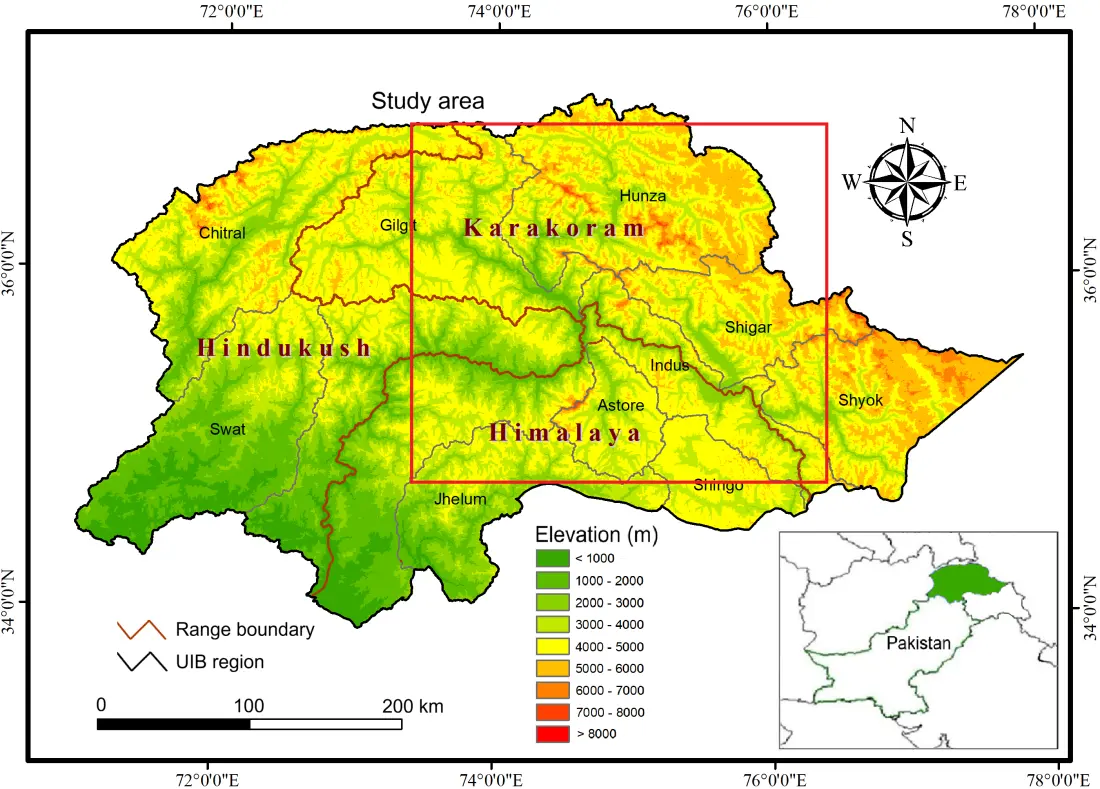
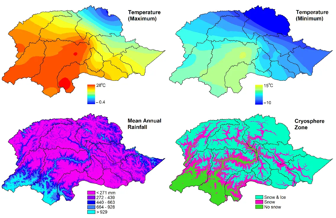
The study area lies in the UIB region, comprised of the Hindu Kush, Karakoram, and Himalayan mountain ranges in northern Pakistan (Figure 1). The climate is diverse, ranging from the monsoon-influenced moist temperate zone in the south to the arid and semi-arid cold desert in the north. The average daily temperature varies from −10 °C in the winter to +35 °C in the summer, while the average annual rainfall is between 200 and 500 mm (Figure 2). Rains are mostly received from the monsoon in the summer and the westerly winds in the winter, with the exception of a small amount from nearby thunderstorms [19]. The weather systems transport moisture and cause precipitation over the high reaches of the glaciated mountain ranges. The cryosphere of the UIB consists of numerous small and massive glaciers, natural lakes, snow-covered areas, permafrost, and high mountain peaks. The melting period of seasonal snow is from April to June, whereas glacier melting begins in July and continues up to September. The major sources of water supply in the region are glaciers, springs, lakes, and river/stream networks. Surface water is the main source of water in the towns, while groundwater is hardly ever used for domestic water supply, with the exception of a few low-lying valleys in the area. In some places, springs are one of the primary sources of drinking water. Most of the area is used for grazing, while agriculture is practiced in less than 2% of the area, lying mostly over the alluvial deposits in the valleys [20]. Dry subtropical, dry temperate coniferous, broad-leaved, and subalpine forests can be found on the mountain slopes [21]. The primary sources of income are tourism, business, trade, employment, and agriculture. About 90% of households work in subsistence farming [22].
1.2. Geology and Landforms
The region consists of rugged topography and steep mountainous terrain with complex geology comprised of igneous and meta-sedimentary rocks. The central and southern areas are home to Paleozoic rocks, which are primarily metamorphic and volcanic, with terraces and gravelly fans, while trace amounts of alluvial deposits occur in the lower portions of the region [23]. Permian rocks are found in some areas, which mainly consist of sandstone, chert, limestone, and shale [24]. A variety of landforms, including mountain-valley systems, weathered bedrock tracks, gravelly fans, alluvial basins, and glacial deposits, have developed in the area due to the intricate geological history of erosion and depositional cycles [16]. The soils in the lowlands are deep, medium-textured, and relatively poorly drained, whereas in the mountains they are shallow to moderately deep, non-calcareous, medium-textured, gravelly, and acidic to moderately alkaline [25]. As a result of natural processes (i.e., glacial retreat, erosion, and landslides), different types of lakes were formed in various landforms of the region [26].
1.3. Lakes in the UIB Region
The lakes in the region are generally fed by the meltwater of snow and glaciers, springs, and precipitation [21]. They can be classified as glacier-fed or non-glacier-fed lakes, depending on their hydrologic connection to their parent glaciers [27]. For example, proglacial lakes that are dammed by loose moraine ridges of glaciers belong to glacier-fed lakes (e.g., Passu Lake), while the lakes filled by rain, snow, or underground springs instead of melting ice are non-glacier-fed lakes (e.g., Sheosar Lake, Upper Kachura Lake). Several lakes were formed due to the damming of rivers by landslides, rockfall, mud, and debris flows. For example, Attabad Lake was formed as a result of a catastrophic landslide event on 4 January 2010, which blocked the Hunza River near Attabad village in the upper Hunza valley [28]. The lakes in the region provide a wide range of ecological and socio-economic benefits and support a rich diversity of plants and animals [29,30]. For example, they provide nesting and staging grounds to migratory birds and waterfowl like Northern Shoveler (Anas clypeata), Common Teal (Anas crecca), Marbled Teal (Marmaronetta angustirostris), Grey Heron (Ardea cinerea), Mallard (Anas platyrhynchos), Northern Pintail (Anas acuta), and Coot (Fulica atra) [5,6]. The migrating birds usually appear between March and June, when they make their way to the cooler climates of Central Asia, and between September and November, when they return to the warmer parts of southern Pakistan. The lakes also support wildlife species like snow leopards (Uncia uncia), brown bears (Ursus arctos), Marco Polo sheep (Ovis ammon polii), and blue sheep (Pseudois nayaur) [31].
2. Materials and Methods
2.1. Data Collection
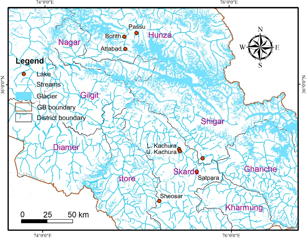
The research employed a multistage, systematic approach encompassing site selection, water sampling, laboratory analysis, data interpretation, and validation to ensure scientifically robust and defensible results. There were eight lakes selected for water quality analysis in the study area (Figure 3), based on a random stratified sampling strategy and key criteria like basin subtype (open vs. closed), proximity to glaciers, bedrock geology, and accessibility. The lakes were sampled once during the 2017–2022 period due to logistical and resource constraints inherent to high-altitude fieldwork. The samples were collected from the outlets of two lakes, i.e., Passu and Lower Kachura, while they were taken from the shores of three closed drainage lakes, i.e., Borith, Sheosar, and Jarbaz Zhou, and from the remaining lakes with their outlets in steep rocky terrain. The selected lakes are located above 2100 m and are therefore referred to as high-altitude alpine lakes. The best time to visit these lakes is between April and October, when the weather is pleasant, and the landscape is free from snow or freezing conditions.
2.1.1. Sheosar Lake
Sheosar Lake (Figure 4a) is situated at a mean elevation of about 4114 m in the Deosai Plains, accessible from Astore and Skardu City via a jeepable road that is mostly open during the summer. The lake is considered to be replenished by snowmelt runoff and subterranean spring water. Deosai is a high-altitude alpine plain, renowned for its diverse flora, golden marmots, and pristine wetlands. The region experiences extreme cold in winters, pleasant weather in summers, and low oxygen and carbon dioxide levels.
2.1.2. Attabad Lake
Attabad Lake, also called Hunza Lake (Figure 4b), is situated at an altitude of about 2500 m along the Karakoram Highway (KKH) in the upper Hunza valley. It is typically a landslide-dammed lake with a total length of about 21 km and a depth of about 109 m. The region experiences heavy snowfall in winter, erratic rainfall, mild summers, and extreme glacial-flood hazards upstream. The lake is a popular spot for boating, jet-skiing, and fishing during the summer.
2.1.3. Borith Lake
Borith Lake (Figure 4c) is situated at an elevation of about 2600 m between the Ghulkin and Passu glaciers and is accessible via a 2 km jeep track from the KKH near Hussaini village in the upper Hunza Valley. The lake is supposed to be fed by the seepage of the nearby glaciers, and due to a decrease in the subterranean seepage and the effects of climate change, the lake has reduced in size and become brackish over time. It has significance as a bird sanctuary for migrating wildfowl (geese, ducks, and swans).
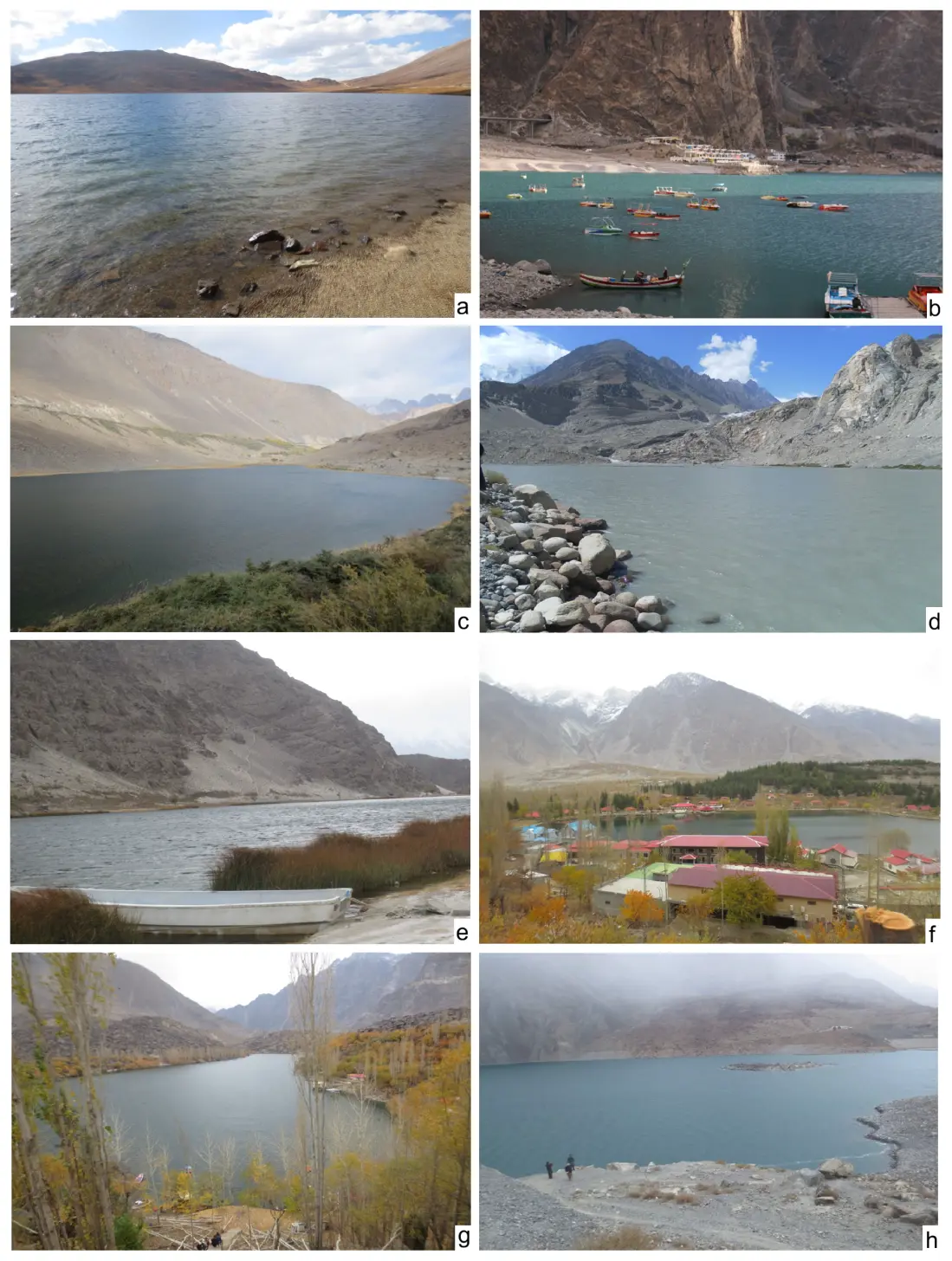
Figure 4. Sheosar Lake surveyed in 2021 (a); Attabad Lake during 2022 (b); Borith Lake in 2017 (c); Passu Lake surveyed in 2022 (d); Jarbaz Zhou Lake in 2022 (e); Lower Kachura Lake during 2022 (f); Upper Kachura Lake in 2022 (g), and Satpara Lake during 2022 (h).
2.1.4. Passu Lake
Passu Lake is an end-moraine-dammed lake (Figure 4d) formed at the terminus of Passu Glacier in the upper Hunza valley. Compared to other large glaciers in the valley, the Passu Glacier (about 21 km in length) is a relatively debris-free glacier. The lake drains into the Hunza River near Passu village, located about 150 km from Gilgit City. The village is famous for splendid views of the jagged Passu Cones (Cathedral Peaks), snow-covered Karakoram peaks, and the Passu and Batura Glaciers.
2.1.5. Jarbaz Zhou Lake
Jarbaz Zhou Lake (Figure 4e), widely known as Blind Lake or Zharba Tso, is situated at a mean elevation of about 2230 m, 30 km northeast of Skardu City, in the rugged mountains of the Shigar district. The lake is called “Blind” because it lacks a direct, visible inflow or outflow, rather, it is nourished by seepage from the nearby Indus and Shigar rivers and by hidden underground springs. The water level of the lake begins to rise in March and reaches its peak in the month of July.
2.1.6. Lower Kachura Lake
Lower Kachura Lake (also known as Shangrila Lake) (Figure 4f) is located at an elevation of about 2500 m, 30 km northwest of Skardu City. The lake is surrounded by fruit orchards, hotels, and residential huts with the Karakoram Mountains in the background, a landscape that makes it an attractive tourist resort.
2.1.7. Upper Kachura Lake
Upper Kachura Lake (Figure 4g), at 2500 m elevation, is a freshwater alpine lake (about 70 m deep) located near the lower Kachura Lake. It is fed primarily by spring water from the inside and drains through subterranean seepage and surface runoff. The area has mild weather during the summer with a mean temperature of about 15 °C, and it is freezing in the winter. It has a rich flora of the Western Himalayan forest ecoregion.
2.1.8. Satpara Lake
Satpara Lake, also named Sadpara Dam (2636 m elevation) (Figure 4h), is located about 9 km from Skardu City. It possesses an area of about 2.7 km2 and a length of over 4 km. The lake, fed by the meltwater of snow and glaciers, is developed into a dam to supply water to Skardu and nearby areas. The lake is a famous tourist destination, which also serves as a stopover for tourists heading to the Deosai Plains and Astore Valley of the GB.
2.2. Field Sampling and Data Analysis
A field sampling campaign was conducted to capture representative conditions of the high-altitude lakes in the study area. Water samples were taken under standard operating procedures to prevent any type of contamination. The water quality parameters measured at the site using pre-calibrated portable instruments were pH, temperature, electrical conductivity (EC), total dissolved solids (TDS), and turbidity. For major ion analysis (Ca2+, Mg2+, Na+, K+, Cl−, SO42−, HCO3−/CO32−), samples were processed and preserved in appropriate containers. A combination of descriptive and geospatial analysis was performed for comparative analysis and geochemical interpretation of the sample data. The measured water quality parameters for each lake were mapped in ArcGIS software to conceive their geographic distribution and association in the region. The primary data were compared with various water quality guidelines to assess overall quality and suitability for drinking and other uses.
The water quality parameters were analyzed statistically using methods like Gibbs diagrams to assess sources of solute in the lakes and the Spearman correlation test for relationship analysis between different parameters. A Gibbs diagram was plotted to determine the source of ion contribution in the lake, i.e., whether precipitation, rock-water interaction (weathering), or evaporation-crystallization dominates the dissolved chemical ingredients [32]. A Spearman correlation matrix was generated in Excel indicating non-parametric rank-based correlations between pairs of different parameters. This correlation test is appropriate for multiple variables having non-normal data distributions [33]. The coefficient values lie between −1 and +1, the former for a perfect negative monotonic trend and the latter for a perfect positive monotonic trend.
3. Results and Discussion
3.1. Physicochemical Analysis
The physicochemical analysis of the selected lakes indicated a significant spatial heterogeneous water quality trend, primarily influenced by geological characteristics, glacial inputs, and hydrological connectivity and, to a lesser extent, by anthropogenic activities [34,35,36]. A striking example of this heterogeneity is Borith Lake, exhibiting exceptionally high levels of EC value (31,300 µS/cm) and TDS (20,032 mg/L) (Table 1). The increased TDS is likely caused by higher concentrations of dissolved solids (salinity), water-rock interaction, and natural weathering of rocks [37,38]. The total hardness in this lake was found to be 10,422 mg/L with elevated levels of magnesium, potassium, and sodium concentrations (Figure 5). These levels substantially surpass standard water quality guidelines for drinking or human consumption [39]. This situation highlights the scenario of a highly prolonged water residence time and closed-basin characteristics of the lake, where dissolved solids and contaminants accumulate over time [40]. The lower EC values, i.e., <300 µS/cm, noticed in the Sheosar, Passu, lower and upper Kachura, and Satpara Lakes indicate dilution of meltwater with minimal weathering inputs or limited interaction of meltwater with soluble geological formations [41].
At the time of sampling, the lakes exhibited slightly alkaline conditions with pH ranging between 7.7 (Lower Kachura) and 8.2 (Sheosar) (Table 1). This alkalinity could be attributed to carbonate-buffered alpine systems [42]. High alkalinity and bicarbonate content (322 mg/L as CaCO3) may indicate carbonate weathering within the lake catchment. The lower alkalinity detected in the lakes, like Sheosar (42 mg/L), may indicate limited buffering capacity and more sensitivity to nutrient pulses or potential acidification. Nitrate-N concentration in most of the selected lakes was found to be low, and in some cases, below detection limits (Table 1). The situation points toward negligible influence of agricultural land use or major farming activity in the lakes’ catchments.
Table 1. Physicochemical analysis of the lakes’ water in the UIB region.
|
Parameter |
Sheosar |
Attabad |
Borith |
Passu |
Jarbaz Zhou |
Lower Kachura |
Upper Kachura |
Satpara |
|---|---|---|---|---|---|---|---|---|
|
Color |
Colorless |
Colorless |
Colorless |
Colorless |
Colorless |
Colorless |
Colorless |
Colorless |
|
EC (µS/cm) |
107 |
373 |
31,300 |
144 |
870 |
178 |
200 |
176 |
|
pH |
8.2 |
8.06 |
7.89 |
7.88 |
8.11 |
7.7 |
8.1 |
8.05 |
|
Alkalinity (mg/L) |
42 |
92 |
322 |
42 |
232 |
52 |
62 |
50 |
|
Bicarbonates (mg/L) |
42 |
92 |
322 |
42 |
232 |
52 |
62 |
50 |
|
Calcium (mg/L) |
17 |
41 |
151 |
17 |
81 |
21 |
21 |
21 |
|
Carbonates (mg/L) |
BDL |
BDL |
BDL |
BDL |
BDL |
BDL |
BDL |
BDL |
|
Chlorides (mg/L) |
10 |
22 |
750 |
10 |
34 |
16 |
16 |
16 |
|
Total Hardness |
52 |
162 |
10,422 |
57 |
302 |
72 |
82 |
77 |
|
Magnesium (mg/L) |
2 |
14 |
2441 |
4 |
24 |
5 |
7 |
6 |
|
Potassium (mg/L) |
1.8 |
3.8 |
940 |
4.6 |
15 |
4.2 |
4.2 |
2 |
|
Sodium (mg/L) |
4 |
9 |
1860 |
5 |
51 |
5 |
5 |
5 |
|
Sulphate (mg/L) |
BDL |
63 |
13,700 |
22 |
152 |
14 |
16 |
21 |
|
Nitrate-N (mg/L) |
0.57 |
0.18 |
0.7 |
BDL |
0.12 |
0.33 |
BDL |
BDL |
|
TDS (mg/L) |
59 |
205 |
20,032 |
79 |
479 |
98 |
110 |
97 |
|
Turbidity (NTU) |
1.67 |
3.19 |
2.42 |
7.54 |
0.8 |
0.69 |
0 |
1.06 |
BDL denotes below detection limit.
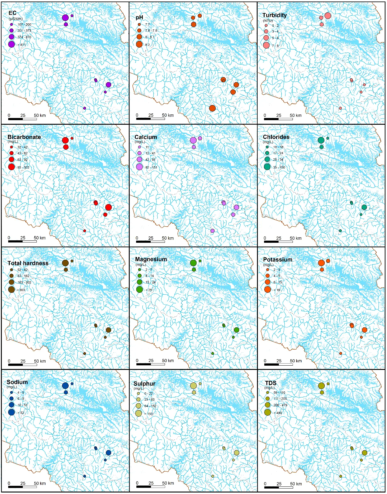
During the study period, turbidity in most of the lakes was observed to be less than 5 NTU (Figure 5), which is considered clean and normal for lake water. A higher turbidity value was observed in the Passu Lake, i.e., 7.54 NTU (Table 1), which might be driven by fine rock flour (glacial flour) suspension in the lake inflows and rapid melting of the mother glacier. The Attabad Lake, a landslide-dammed reservoir formed in 2010, exhibited intermediate water quality (EC = 373 µS/cm, TDS = 205 mg/L). This underscores the water quality implications of a recently formed lake as a result of a natural event. According to the hydrochemical data plotted in the Gibb’s diagram, seven samples were shown in the rock dominance zone, pointing toward chemical weathering of rocks as the major factor contributing ions to the lake water (Figure 6). In one sample, i.e., Borith Lake, evaporation-crystallization was found to be the likely process causing dissolved chemical ingredients in the lake. The Spearman rank-correlation matrix indicated a close positive correlation between EC and TDS, i.e., conductivity rises with dissolved ions (Figure 7). A higher positive correlation (r > 0.9) was observed between Ca and Mg, likely due to carbonate rock weathering.
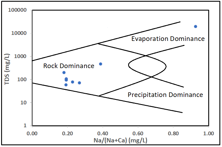
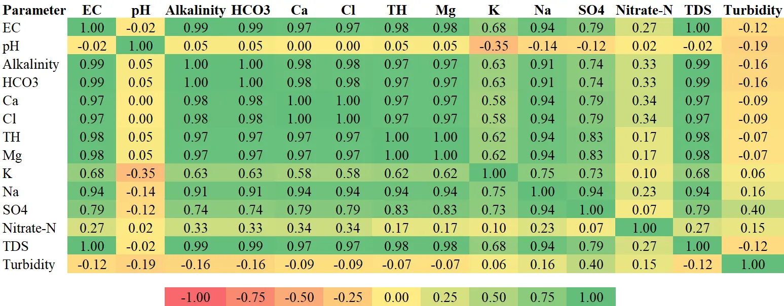
Figure 7. Spearman’s rank correlation coefficients indicating association between different parameters.
3.2. Water Quality Implications
The reported variations in water quality parameters may have serious implications for human and animal water consumption, health, and ecological integrity [43]. For instance, high EC and total hardness values of Borith Lake’s water make it unsuitable for human consumption, domestic or irrigation use without treatment. Higher levels of dissolved solids in drinking water, including sulfates, can pose significant risks to human health [44]. High sulfate and chloride levels can induce gastrointestinal disorders in livestock. The pristine lakes, such as Jarbaz Zhou and Sheosar, may be suitable as freshwater reservoirs; however, they could possess low buffering capacities, rendering their beneficiaries vulnerable to changes in water quality. The elevated turbidity in lakes could influence the aquatic life by reducing light penetration [45]. The temperature warming predicted in the region may result in higher liquid precipitation and depletion of glaciers [46,47]. As the meltwater dilution generally controls the seasonal hydrochemical variation in glacial lakes [48], the regular monitoring of the lake water quality would be beneficial in comprehending such changes over time [15]. While the findings of this study offer a first comparative overview of hydrochemical variability across the UIB lakes, the absence of temporal replication limits causal attribution. We therefore treat these results as hypothesis-generating, to be tested through future systematic monitoring.
4. Conclusions
The current study focuses on establishing a preliminary physicochemical baseline for eight high-altitude lakes in the UIB, Pakistan, to characterize their spatial hydrochemical variability and identify potential water quality concerns in the region. The findings of the study revealed that the water quality of the lakes is not merely a function of melt driven by climate in this region, but it is also modulated by basin morphology, lithology, and evolving socio-environmental factors. The pristine lakes, such as Jarbaz Zhou and Sheosar, may be suitable as freshwater reservoirs; however, they could possess low buffering capacities, rendering their beneficiaries vulnerable to changes in water quality. The reported variations in the water quality parameters may have high implications for human health and the environment, which need to be addressed properly for effective resource conservation and management. This study contributes a first-of-its-kind physicochemical inventory of eight high-altitude lakes in the UIB. These baseline data can serve as a reference point for future monitoring programs and support evidence-based water resource management in the region.
Since this study is based on one-time data acquisition due to resource constraints, it is recommended that a detailed water quality analysis be performed, considering the seasonal and annual variabilities in lake water arising from changes in climate and cryosphere in the region. Moreover, the changes in climate (temperature and precipitation), land use, river flows, and cryosphere need a thorough assessment for effective conservation of the lake ecosystems. Regular monitoring of the lakes would facilitate conceiving the stability and health of the lake ecosystem and support future conservation efforts in the region. The impacts of climate and cryosphere change on lake ecosystems need to be investigated through ground-based and modeling techniques to develop viable conservation strategies for the region. A thorough appraisal of the ecological, economic, and cultural benefits of the lakes is essential to support conservation efforts and make proactive decisions at the policy level in future.
Acknowledgments
The technical and financial support by Pakistan Agricultural Research Council (PARC), Ministry of National Food Security and Research, and laboratory support by Pakistan Council of Research in Water Resources (PCRWR) for the execution of this study are highly acknowledged. We are also thankful to the GIS team of the Climate, Energy, and Water Research Institute for providing data acquisition and processing support during this study.
Author Contributions
Conceptualization, A.A.; Methodology, A.A. and A.S.; Software, A.A. and M.B.I.; Formal Analysis, A.A., A.S. and U.T.; Investigation, A.S.; Data Curation, M.B.I.; Writing—Original Draft Preparation, A.A., A.S. and U.T.; Writing—Review & Editing, A.A.
Ethics Statement
Not applicable.
Informed Consent Statement
Not applicable.
Data Availability Statement
The datasets generated during the current study are available from the corresponding author on reasonable request.
Funding
This research received no external funding.
Declaration of Competing Interest
The authors declare that they have no known competing financial interests or personal relationships that could have appeared to influence the work reported in this paper.
References
- UNEP. The Value of Freshwater Ecosystems and the Benefits from Their Restoration. 2022. Available online: https://www.unep-wcmc.org/en/news/the-value-of-freshwater-ecosystems-and-the-benefits-from-their-restoration (accessed on 8 July 2026).
- Ferreira CSS, Kašanin-Grubin M, Solomun MK, Sushkova S, Minkina T, Zhao W, et al. Wetlands as nature-based solutions for water management in different environments. Curr. Opin. Environ. Sci. Health 2023, 33, 100476. DOI:10.1016/j.coesh.2023.100476 [Google Scholar]
- Xia P, Peng J, Gu T, Yu S, Xu Z. Lake‐related ecosystem services facing social–ecological risks. People Nat. 2025, 7, 734–751. DOI:10.1002/pan3.70015 [Google Scholar]
- Ashraf A, Iqbal MB, Mustafa N, Naz R, Ahmad B. Prevalent risk of glacial lake outburst flood hazard in the Hindu Kush–Karakoram–Himalaya region of Pakistan. Environ. Earth Sci. 2021, 80, 451. DOI:10.1007/s12665-021-09740-1 [Google Scholar]
- WWF. Saving Wetlands Sky High Programme, Country Strategy for Pakistan; WWF: Gland, Switzerland, 2011; p. 33. [Google Scholar]
- Khan B, Khan MZ, Ali R, Khan G, Ali F, Ali M. Shimshal Pamir lakes: A prospective high altitude wetlands site for transboundary collaboration between China and Pakistan. Rec. Zool. Surv. Pak. 2012, 21, 1–9. [Google Scholar]
- Ning W, Rawat GS, Joshi S, Ismail M, Sharma E. High-Altitude Rangelands and Their Interfaces in the Hindu Kush Himalayas; ICIMOD: Kathmandu, Nepal, 2013. [Google Scholar]
- Ndayiragije JM, Fang H, Abiduhaye N, Nduwimana L, Mbonihankuye S, Shi M, et al. Exploring socio environmental benefits of floodwater utilization in a changing climate world. Science 2025, 28, 113646. DOI:10.1016/j.isci.2025.113646 [Google Scholar]
- Brenckman CM, Parameswarappa Jayalakshmamma M, Pennock WH, Ashraf F, Borgaonkar AD. A Review of Harmful Algal Blooms: Causes, Effects, Monitoring, and Prevention Methods. Water 2025, 17, 1980. DOI:10.3390/w17131980 [Google Scholar]
- Wang Y, Xu H, Zhao X, Kang L, Qiu Y, Paerl H, et al. Rainfall impacts on nonpoint nitrogen and phosphorus dynamics in an agricultural river in subtropical montane reservoir region of southeast China. J. Environ. Sci. 2025, 149, 551–563. DOI:10.1016/j.jes.2024.02.012 [Google Scholar]
- GB-EPA. Assessment of Drinking Water Quality “Natural Springs and Surface Water”; Report of Gilgit-Baltistan Environmental Protection Agency; Government of Gilgit-Baltistan: Gilgit, Pakistan, 2019. [Google Scholar]
- GoGB. Gilgit-Baltistan at a Glance 2021; Statistical & Research Cell (SRC), Planning and Development Department, Government of Gilgit-Baltistan: Gilgit, Pakistan, 2021. [Google Scholar]
- GoGB. Gilgit-Baltistan at a Glance 2023; Statistical & Research Cell (SRC), Planning and Development, Government of Gilgit-Baltistan: Gilgit, Pakistan, 2023. [Google Scholar]
- Fatima SU, Khan MA, Alamgir A, Sulman N, Khan TMA, Khan FA, et al. Water quality evaluation of Chapurson Valley in Hunza Nagar, Gilgit Baltistan, Pakistan, Based on statistical analysis and water quality Index. Health 2023, 15, 379–396. DOI:10.4236/health.2023.155026 [Google Scholar]
- Ali G, Abbas S, Nagai S, Mohd Arshad N, Bhassu S. Threats of climate change to freshwater ecosystems in Pakistan: eDNA monitoring will be the next-generation tool used in biodiversity, conservation, and management. Biology 2025, 14, 1191. DOI:10.3390/biology14091191 [Google Scholar]
- Ashraf A, Ahmad I. Evaluation of soil loss severity and ecological restoration approach for sustainable agriculture in the Hindu Kush, Karakoram and Himalaya region. J. Mt. Sci. 2024, 21, 1509–1521. DOI:10.1007/s11629-023-8385-y [Google Scholar]
- Ejiohuo O, Onyeaka H, Akinsemolu A, Nwabor OF, Siyanbola KF, Tamasiga P, et al. Ensuring water purity: Mitigating environmental risks and safeguarding human health. Water Biol. Secur. 2025, 4, 100341. DOI:10.1016/j.watbs.2024.100341 [Google Scholar]
- Laskotra L, Bala R, Gaba R. Identifying sources of water pollution. In Biotechnology Innovations for a Sustainable Future; Sobti RC, Ed.; Springer: Singapore, 2026. DOI:10.1007/978-981-97-9859-9_76 [Google Scholar]
- Khan S, Javed ZH, Wahid A, Ranjha AN, Hasan MU. Climate of the Gilgit-Baltistan Province, Pakistan. Int. J. Econ. Environ. Geol. 2020, 11, 16–21. DOI:10.46660/int.j.econ.environ.geol..v11i3.269 [Google Scholar]
- Hussain A, Khan S, Liaqat S, Shafiullah S. Developing Evidence Based Policy and Programmes in Mountainous Specific Agriculture in Gilgit-Baltistan and Chitral Regions of Pakistan. Pak. J. Agric. Res. 2022, 35, 181–196. DOI:10.17582/journal.pjar/2022/35.1.181.196 [Google Scholar]
- Rao AL, Marwat AH. NASSD Background Paper: Forestry; IUCN Pakistan, Northern Areas Progamme: Gilgit, Pakistan, 2003; pp. xii+66. [Google Scholar]
- GoGB, IFAD. Economic Transformation Initiative Gilgit-Baltistan; Programme Design Report; Planning and Development Department Government of Gilgit-Baltistan Gilgit: Gilgit, Pakistan, 2021; Programme Management Department, Asia and the Pacific Division, International Fund for Agricultural Development (IFAD): Rome, Italy, 2021. Available online: https://www.ifad.org/en/w/projects/2000000836 (accessed on 20 June 2026).
- Ashraf A, Ali M. Prospecting groundwater potential using vertical electrical sounding technique for sustainable agriculture in the Upper Indus Basin, Pakistan. J. Mt. Sci. 2025, 22, 4012–4023. DOI:10.1007/s11629-024-8912-5 [Google Scholar]
- Kazmi AH, Jan Q. Geology and Tectonics of Pakistan; Graphic Publishers: Karachi, Pakistan, 1997. [Google Scholar]
- Soil Survey Report. Integrated Land Resource Survey and Evaluation of Azad Jammu & Kashmir Area; Soil Survey of Pakistan: Lahore, Pakistan, 2006. [Google Scholar]
- Lehner B. Chapter 4—Rivers and Lakes—Their distribution, origins, and forms. In Wetzel’s Limnology, 4th ed.; Jones ID, Smol JP, Eds.; Academic Press: Cambridge, MA, USA, 2024; pp. 25–56. DOI:10.1016/B978-0-12-822701-5.00004-5 [Google Scholar]
- Wang W, Xiang Y, Gao Y, Lu A, Yao T. Rapid expansion of glacial lakes caused by climate and glacier retreat in the Central Himalayas. Hydrol. Process 2015, 29, 859–874. DOI:10.1002/hyp.10199 [Google Scholar]
- Rashid MU, Ahmed W, Islam I, Petrounias P, Giannakopoulou PP, Koukouzas N. Impact of Climate Change on the Stability of the Miacher Slope, Upper Hunza, Gilgit Baltistan, Pakistan. Climate 2023, 11, 102. DOI:10.3390/cli11050102 [Google Scholar]
- GoP, IUCN. Northern Areas State of Environment and Development; Government of Pakistan: Islamabad, Pakistan, 2003; IUCN Pakistan: Karachi, Pakistan, 2003; p. 301. [Google Scholar]
- IWMI. Water Policy Briefing: Putting Research Knowledge into Action. Working Wetlands: A New Approach to Balancing Agricultural Development with Environmental Protection; International Water Management Institute: Colombo, Sri Lanka, 2006; Issue 21. [Google Scholar]
- Khan B, Ablimit A, Khan G, Jasra AW, Ali H, Ali R, et al. Abundance, distribution and conservation status of Siberian ibex, Marco Polo and Blue sheep in Karakoram-Pamir mountain area. J. King Saud. Univ.-Sci. 2016, 28, 216–225. DOI:10.1016/j.jksus.2015.02.007 [Google Scholar]
- Gibbs RJ. Mechanisms Controlling World Water Chemistry. Science 1970, 170, 1088–1090. DOI:10.1126/science.170.3962.1088 [Google Scholar]
- Muloogi D, Wilson GJL, Ahmed FT, Polya DA, Richards LA. Spatial variations in groundwater chemistry in Uganda: Geogenic origins and geochemical controls across diverse hydrogeological settings. Appl. Geochem. 2026, 200, 106738. DOI:10.1016/j.apgeochem.2026.106738 [Google Scholar]
- Kaushik H, Soheb M, Biswal K, Ramanathan AL, Kumar O, Patel AK. Understanding the hydrochemical functioning of glacierized catchments of the Upper Indus Basin in Ladakh, Indian Himalayas. Environ. Sci. Pollut. Res. 2022, 30, 20631–20649. DOI:10.1007/s11356-022-23477-9 [Google Scholar]
- Khan M, Ellahi A, Niaz R, Ghoneim ME, Tag-eldin E, Rashid A. Water quality assessment of alpine glacial blue water lakes and glacial-fed rivers. Geomat. Nat. Hazards Risk 2022, 13, 2597–2617. DOI:10.1080/19475705.2022.2126800 [Google Scholar]
- Kleinteich J, Hanselmann K, Hildebrand F, Kappler A, Zarfl C. Glacier melt-down changes habitat characteristics and unique microbial community composition and physiology in alpine lake sediments. FEMS Microbiol. Ecol. 2022, 98, fiac075. DOI:10.1093/femsec/fiac075 [Google Scholar]
- Sinyukovich VN. Relationships between water flow and dissolved solids discharge in the major tributaries of Lake Baikal. Water Resour. 2003, 30, 186–190. DOI:10.1023/A:1022918105238 [Google Scholar]
- Li D, Chen H, Jia S, Lv A. Possible hydrochemical processes influencing dissolved solids in surface water and groundwater of the Kaidu River Basin, Northwest China. Water 2020, 12, 467. DOI:10.3390/w12020467 [Google Scholar]
- WHO. Guidelines for Drinking-Water Quality: Incorporating the First and Second Addenda; World Health Organization: Geneva, Switzerland, 2022. [Google Scholar]
- Ren X, Yu R, Kang J, Lü C, Wang R, Li Y, et al. Water pollution characteristics and influencing factors of closed lake in a semiarid area: A case study of Daihai Lake, China. Environ. Earth Sci. 2022, 81, 393. DOI:10.1007/s12665-022-10526-2 [Google Scholar]
- Zhang F, Qaiser FUR, Zeng C, Pant RR, Wang G, Zhang H, et al. Meltwater hydrochemistry at four glacial catchments in the headwater of Indus River. Environ. Sci. Pollut. Res. 2019, 26, 23645–23660. DOI:10.1007/s11356-019-05422-5 [Google Scholar]
- Müller B, Meyer JS, Gächter R. Alkalinity regulation in calcium carbonate-buffered lakes. Limnol. Oceanogr. 2016, 61, 341–352. DOI:10.1002/lno.10213 [Google Scholar]
- Wu R, Dong Z, Cheng X, Brahney J, Jiao X, Wu L. Heavy metal levels and sources in suspended particulate matters of the glacier watersheds in Northeast Tibetan Plateau. Front. Environ. Sci. 2022, 10, 918514. DOI:10.3389/fenvs.2022.918514 [Google Scholar]
- Bashir MT, Ali S, Bashir A. Health effects from exposure to sulphates and chlorides in drinking water. Pak. J. Med. Health Sci. 2012, 6, 648–652. [Google Scholar]
- Sahoo D, Anandhi A. Conceptualizing turbidity for aquatic ecosystems in the context of sustainable development goals. Environ. Sci. Adv. 2023, 2, 1220–1234. DOI:10.1039/D2VA00327A [Google Scholar]
- Ali S, Li D, Congbin F, Khan F. Twenty first century climatic and hydrological changes over Upper Indus Basin of Himalayan region of Pakistan. Environ. Res. Lett. 2015, 10, 014007. DOI:10.1088/1748-9326/10/1/014007 [Google Scholar]
- Khan H, Baig S. High Altitude Wetlands of the HKH Region of Northern Pakistan—Status of Current Knowledge, Challenges and Research Opportunities. Wetlands 2017, 37, 371–380. DOI:10.1007/s13157-016-0868-y [Google Scholar]
- Saberi L, Crystal Ng GH, Nelson L, Zhi W, Li L, La Frenierre J, et al. Spatiotemporal drivers of hydrochemical variability in a tropical glacierized watershed in the Andes. Water Resour. Res. 2021, 57, e2020WR028722. DOI:10.1029/2020WR028722 [Google Scholar]