Flooding in coastal river basins is shaped by the temporal interaction of upstream hydrological forcing and downstream hydraulic conditions, yet such processes remain difficult to characterize in data-limited regions. This study investigates the hydrological evolution of the November 2025 flood in the Cai Nha Trang River Basin, Vietnam, using water-level observations from the Dong Trang and Dien Phu hydrological stations, discharge observations at Dong Trang, rainfall records, tidal-level data, and post-flood field observations. Hydrograph-derived indicators characterized flood magnitude, evolution, and persistence, with the event examined as two successive flood phases. The first phase reached a water level of 12.24 m and a maximum discharge of 3180 m3·s−1 at Dong Trang, while the second phase reached 13.14 m and 3720 m3·s−1. The second phase followed substantially greater antecedent rainfall and produced longer exceedance of the official flood-warning levels. The observations indicate that the November 2025 flood was characterized by successive hydrometeorological forcing and contrasting upstream–downstream responses. However, the Dien Phu water-level record was interrupted by sensor inundation during the second phase; therefore, the 6.73 m value represents the maximum observed downstream level before the sensor was lost rather than the absolute downstream peak. Downstream field observations of floodplain encroachment, channel narrowing, and hydraulic infrastructure provide evidence of potential constraints on flood conveyance, but do not establish their causal contribution to the event. The findings support ecological river regulation as a basin-scale management perspective emphasizing functional connectivity among rivers, floodplains, estuarine pathways, and coastal waters.
Climate change poses a major challenge to water-resource management in West Africa’s Sudano-Sahelian regions. This study assesses projected changes in runoff in Senegal’s Nanija Bolong catchment using ISIMIP3b outputs from two global hydrological models (H08 and Climate, Weather and Atmospheric Modeling (CWATM)) driven by three CMIP6 climate models (GFDL-ESM4, MPI-ESM1-2-HR, and MRI-ESM2-0). The analysis uses 1985–2014 as the historical reference period and 2021–2100 for future projections under SSP1-2.6, SSP3-7.0, and SSP5-8.5. Mann–Kendall, Sen’s slope, and Pettitt tests were applied to the simulated series. The historical analysis shows no statistically significant trend in the simulated runoff series. Future changes differ in magnitude between H08 and CWATM and are not monotonic across scenarios in every time window: relative to 1985–2014, the late-century reductions under SSP3-7.0 are larger than under SSP5-8.5 in the ensemble series. Because a complete, independently documented observed Nanija Bolong discharge series was not available in the material used for this analysis, the study does not claim observational validation of either model. The results should therefore be interpreted as model-based projections and as an assessment of structural and climate-model uncertainty, not as proof that either model reproduces measured discharge accurately. The coarse spatial resolution also limits fine-scale interpretation within this small catchment.
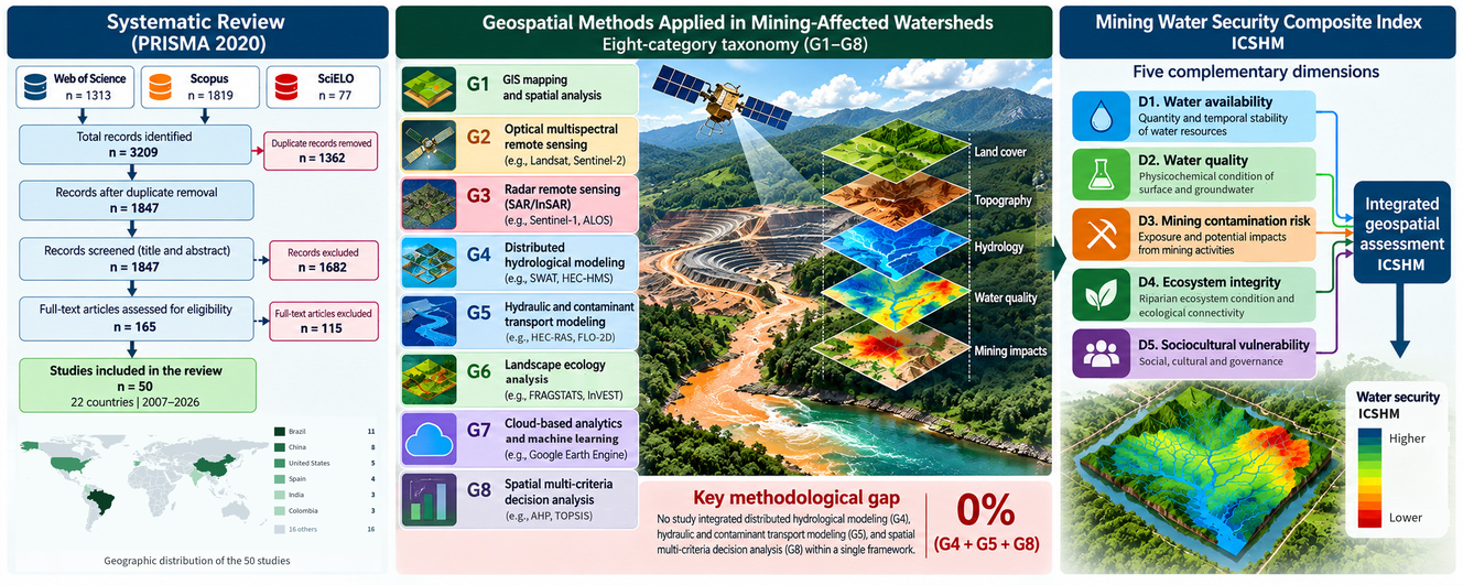
Mining activities constitute one of the most significant anthropogenic pressures on freshwater systems worldwide, producing diverse impacts on water availability, water quality, and ecosystem integrity. Despite substantial advances in geospatial technologies, none of the assessment frameworks identified in the reviewed corpus comprehensively integrates these dimensions for mining-affected watersheds. This systematic review aimed to identify, classify, and synthesize water security indices and geospatial assessment frameworks applied to mining-affected watersheds worldwide, develop an original taxonomy describing their methodological structure, and identify the research gaps supporting the development of the Mining Water Security Composite Index ICSHM. Following the Preferred Reporting Items for Systematic Reviews and Meta-Analyses (PRISMA) 2020 (Preferred Reporting Items for Systematic Reviews and Meta-Analyses) guidelines, systematic searches were conducted in the Web of Science, Scopus, and SciELO databases, covering the period from 2007 to 2026 (3209 initial records). Reference management and screening were performed using Zotero 7.0 and Rayyan. Data extraction was based on an original eight-category geospatial taxonomy (G1–G8) covering Geographic Information Systems (GIS) mapping, optical and radar remote sensing, distributed hydrological modeling, hydraulic and contaminant transport modeling, landscape ecology, cloud-based analytics, and spatial multi-criteria decision analysis, while methodological quality was assessed using an adapted Critical Appraisal Skills Programme (CASP)–Joanna Briggs Institute (JBI) framework. From 1847 unique records screened, 50 studies conducted across 22 countries met the inclusion criteria. The review identified two major methodological gaps. First, none of the 17 identified water security indices simultaneously incorporates the five dimensions proposed in this review for the assessment of mining-affected watersheds. Second, none of the reviewed studies integrates distributed hydrological modeling, hydraulic and contaminant transport modeling, and spatial multi-criteria analysis within a single assessment framework (G4 + G5 + G8 = 0%). These findings provide a strong methodological rationale for the proposed ICSHM, which is structured around five complementary dimensions: water availability, water quality, mining contamination risk, ecosystem integrity, and sociocultural vulnerability. The framework integrates geospatial methods represented by categories G1–G8 and is designed to support future validation across mining-affected watersheds with contrasting environmental and mining settings.
Machine learning (ML) has been widely used to predict nonlinear relationships among water quality variables and to address complex ecological problems. However, the ML models’ results are sometimes interpreted as real ecological findings. ML tools like explainable artificial intelligence explain model behavior but not the natural processes occurring in the water system. We define this limitation as an “interpretability gap” between the output of ML models and ecological causality. For example, in a random forest model of benthic chlorophyll-a, colloidal phosphorus was the most influential predictor, but algae cannot take up colloidal phosphorus directly. A practical rule is to check whether a variable can affect the response directly before calling it a driver. This can lead to incorrect conclusions, especially when input variables are highly collinear, as in nutrient cycling and across physical and biological processes. This interpretability gap is not only a technical issue in ML models but also a major scientific concern that may lead a new researcher down the wrong track. To address this limitation, we proposed a process-based hydraulic and biogeochemical model alongside ML models, because high accuracy must be supported by ecological understanding. Closing this gap is essential for making ML results more reliable for science and decision-making. We frame this challenge from a watershed perspective, since the watershed is widely recognized as the fundamental spatial unit for integrating the hydrological, biogeochemical, and land-use processes that jointly determine water quality outcomes.

