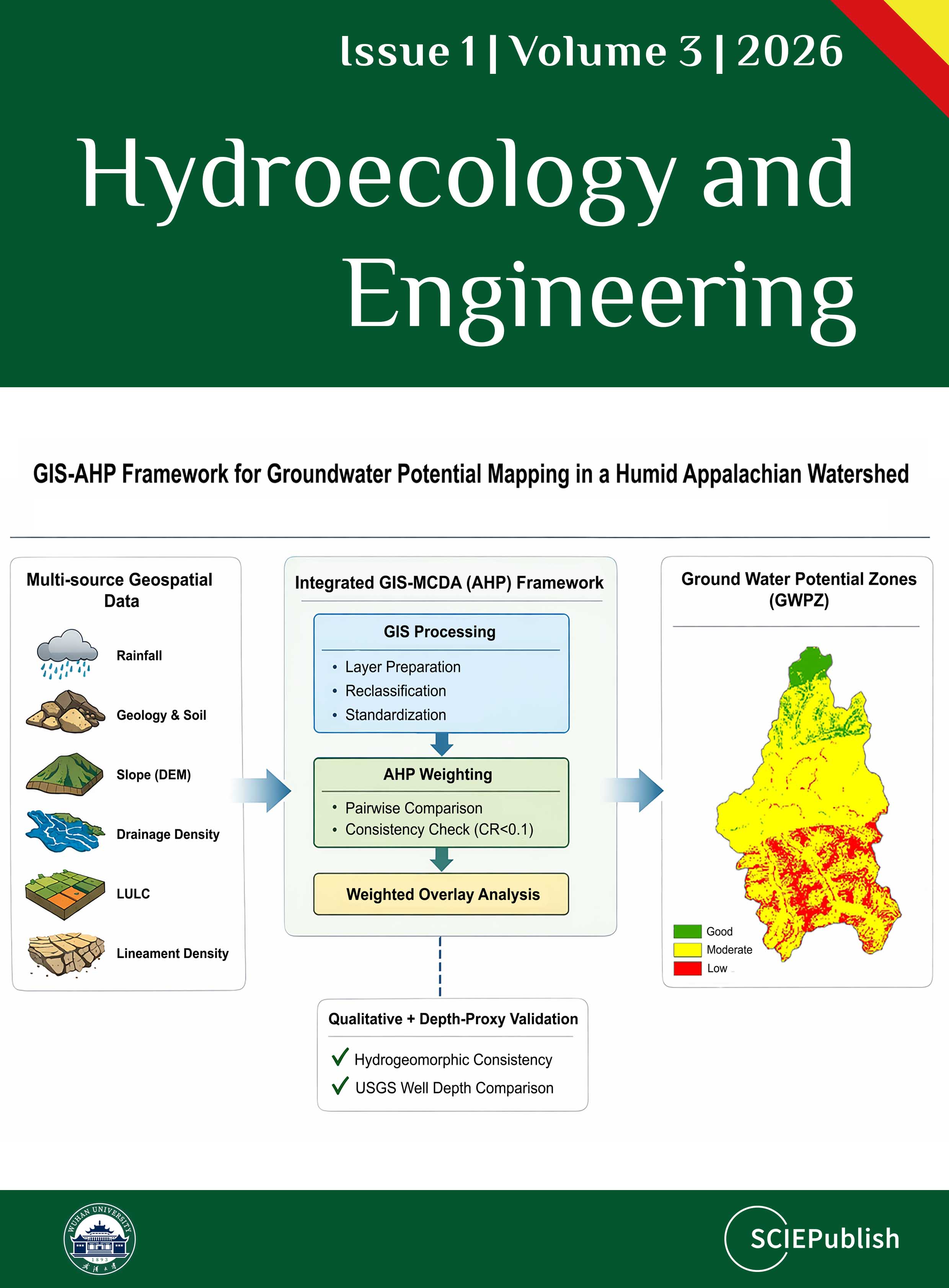
Mapping the potential of groundwater is important for managing water resources in a way that will last, especially when the climate changes, land use changes, and water demand rise. This study examines the integration of Geographic Information Systems (GIS) and Multi-Criteria Decision Analysis (MCDA) methodologies, focusing on the Analytical Hierarchy Process (AHP), and illustrates their implementation in the Fork Fish Creek watershed, a humid Appalachian headwater basin in West Virginia, USA. Although GIS–AHP methodologies are extensively utilized in semi-arid areas, their efficacy in humid, structurally intricate mountainous environments is still inadequately investigated. Using expert-based AHP weighting and GIS-based weighted overlay analysis, six thematic parameters were combined: rainfall, geology and soil characteristics, slope, drainage density, land use and land cover (LULC), and lineament density. The appropriate AHP consistency ratio (<0.1) showed that the weights were reliable. The resulting groundwater potential map divided the watershed into three zones: Good (6.7%), Moderate (76.5%), and Low (16.8%). The prevalence of Moderate potential indicates the impact of fragmented topography and drainage configuration, which limit groundwater storage despite sufficient precipitation. Validation encompassed an evaluation of hydrogeomorphic consistency and an additional comparison with USGS monitoring-well depth data, so offering empirical corroboration for the Moderate-dominated distribution. The results show that groundwater potential patterns vary greatly from one place to the next. They also show how useful GIS–MCDA frameworks may be for assessing groundwater in humid, data-poor mountainous areas.

This study aims to promote residential rainwater harvesting everywhere rain falls. It recalls the history of urban rainwater (stormwater) management while insisting on the origin of the perception that rainwater is not a relevant source of potable water. It also argues that where rainwater is polluted, it can be easily treated using frugal technologies such as filtration on metallic iron-based filters. The study notes that stormwater is precipitation that is not harvested. Thus, harvesting rainwater prevents (quantitative) stormwater generation, and transforms stormwater from a threat (e.g., erosion, floods) to a resource (e.g., drinking water, food security) for human and environmental needs. The effective management of stormwater (i) enhances the quality of human life, (ii) sustains local biodiversity, and (iii) protects the whole environment. Thus, the failure to harvest rainwater should be considered irresponsible, if not unethical. This argument alone makes each conscientious citizen a changemaker. A number of local changemakers will organize to determine the best way to integrate overflow from individual residences to enhance the community’s liveability. This study provides a valuable consolidation of information that will facilitate the mainstreaming of rainwater harvesting as the pillar of holistic integrated water resource management.
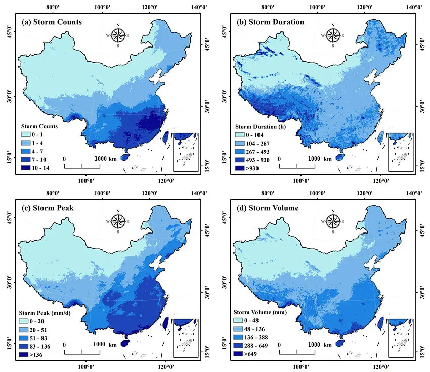
In order to reveal the spatio-temporal evolution of extreme rainstorm events in China and the changing characteristics of population exposure in different periods, this study systematically explored the spatio-temporal evolution characteristics of four indicators of extreme rainstorm frequency, duration, peak and cumulative amount, as well as the difference of population exposure to extreme rainstorm events in 2000 and 2020, based on the relevant data of extreme rainstorm and population distribution grid data from 2000 to 2020, using spatial analysis and trend analysis methods. The results show that in space, the frequency, peak value, and cumulative amount of extreme rainstorms are increasing from northwest to southeast, the southeast coast is a high value area, and there is almost no extreme rainstorm in the northwest arid area; The high-value areas of duration are concentrated in the Qinghai Tibet Plateau and Northeast China. In terms of time, from 2000 to 2020, the frequency of extreme rainstorm in Northeast China increased, the southern part of the Qinghai Tibet Plateau and other regions decreased, the peak value of rainstorm in North China Plain and the eastern coast increased, Taiwan Province showed a significant downward trend, and the change rate of rainstorm accumulation was stronger in the south and weaker in the north. In terms of spatial concentration, the high value concentration area of extreme rainstorms generally shifts to South China, while the low value concentration area is stably distributed in the northwest and part of the north. In terms of population exposure, the distribution characteristics of 2000 and 2020 are low in the northwest and high in the southeast, and the exposure of capital cities in southeast coastal provinces to extreme rainstorm frequency and peak in 2020 is significantly higher than that in 2000. Population migration and the evolution of extreme rainstorm events are the main driving factors. This study clarifies the temporal and spatial evolution law of extreme rainstorm events in China and the characteristics of population exposure change, which provides a scientific basis for regional extreme rainstorm disaster risk assessment, disaster prevention and mitigation planning, and optimization of population and urban development layout, and has important practical significance for improving the ability to respond to extreme climate events and ensuring regional population security and sustainable development.