β-N-methylamino-L-alanine (BMAA), a non-proteinogenic amino acid produced by various cyanobacteria, has emerged as a significant concern in the context of the One Health framework due to its neurotoxic effects and potential ecological and public health implications. Cyanobacteria, found ubiquitously in freshwater, marine, and terrestrial environments, can contaminate water sources and food chains with different toxins, including BMAA, which can produce a sinergic action with other environmental neurotoxic contaminants (such as Methylmercury) and other cyanotoxins, such as Microcystins. Human exposure occurs primarily through the consumption of contaminated drinking water and aquatic food products. BMAA accumulation in neural tissues has been linked to the degeneration of motor neurons and the formation of neurofibrillary tangles, mimicking pathological features observed in amyotrophic lateral sclerosis (ALS) and Alzheimer’s disease. This exposure is associated with a spectrum of symptoms, collectively termed ALS/parkinsonism dementia complex (ALS/PDC), characterized by progressive muscular paralysis, rigidity, cognitive decline, and ultimately, fatal outcomes. The increasing prevalence of cyanobacteria blooms, driven by climate change and anthropogenic factors, underscores the urgent need for comprehensive research into BMAA toxicity, environmental monitoring, and mitigation strategies. This work shows BMAA contamination data of fish fauna living in several Italian lakes affected by recurrent cyanobacterial blooms, quantified by Elisa Assay. It also explores the emerging issue of BMAA contamination from a One Health perspective, highlighting its multifaceted impact on ecosystems, animal health, and human well-being.
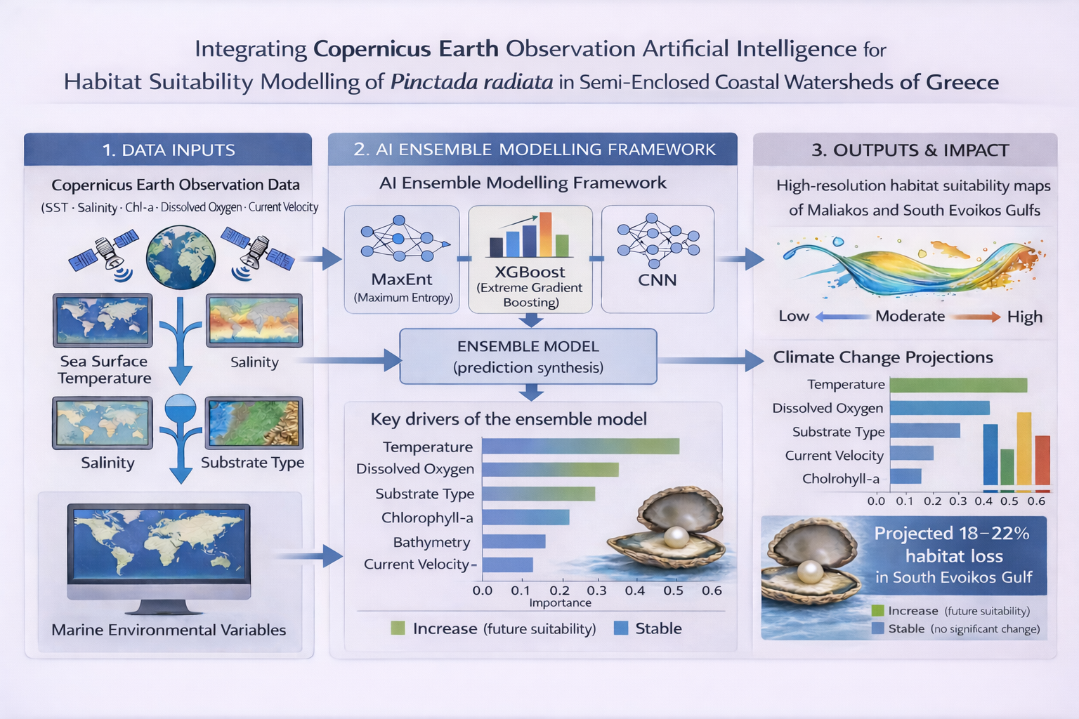
Semi-enclosed coastal systems are highly dynamic environments where benthic organisms are exposed to strong hydrographic gradients and increasing anthropogenic pressures. This study assessed the habitat suitability of the pearl oyster Pinctada radiata in two contrasting Mediterranean gulfs of Central Greece, the Maliakos and the South Evoikos, by integrating Copernicus Earth Observation (EO) products with an Artificial Intelligence (AI) modeling framework. Environmental variables, including sea surface temperature, salinity, chlorophyll-a concentration, current velocity, and dissolved oxygen, were derived from satellite and marine datasets and used to train a multi-algorithm ensemble combining Maximum Entropy (MaxEnt), Extreme Gradient Boosting (XGBoost), and a Convolutional Neural Network (CNN). The ensemble model showed strong predictive skill (AUC = 0.94; TSS = 0.80) and identified temperature, dissolved oxygen, and substrate type as the main drivers of habitat suitability. Spatial projections indicated that roughly two-thirds of the study area currently supports favorable conditions for P. radiata, particularly in shallow, low-energy, mesotrophic zones. Under a simulated +2 °C warming scenario, highly suitable habitats declined by about 20%, highlighting the species’ sensitivity to future thermal stress and subsequent oxygen depletion, demonstrating the value of EO-driven AI approaches for anticipating ecological change in vulnerable coastal systems.
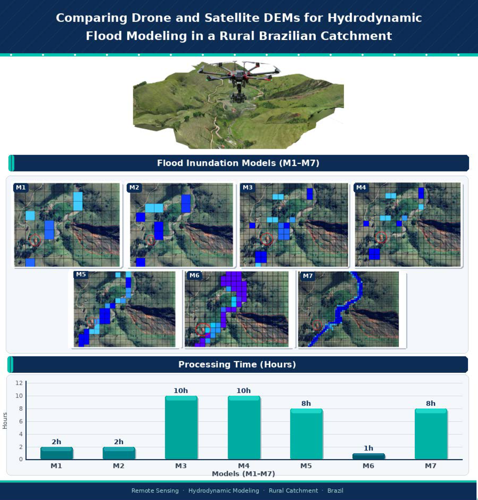
The rural region of the municipality of Bananal (SP, Brazil) experiences recurrent flooding events associated with rising water levels in tributaries of the Bananal River, especially during periods of intense rainfall. This study aimed to compare the performance of different Digital Elevation Models (DEMs), one derived from NASA orbital data and another generated from drone-based aerophotogrammetric surveys, in identifying and mapping flood-prone areas. The objective was to assess whether drone field campaigns are essential for this type of analysis or whether orbital DEMs are sufficient for the hydrodynamic characterization of the area. Hydrodynamic models were developed using the software QGIS, HidroFlu—for watershed parametrization and inflow estimation, and MODCEL—for hydrodynamic simulation, with spatial resolutions of 10 m, 30 m, and 50 m, in order to analyze the impact of topographic detail on simulation results. Two approaches were tested for defining boundary conditions: one based on precipitation data with a 25-year return period, and another based on the Bananal River discharge estimated from the watershed. The results indicated that the model based on the drone-derived DEM, with 10 m resolution and boundary conditions defined by river discharge, showed the best performance in representing floodable areas. However, the findings also highlight that high-resolution DEMs entail higher operational costs, due to the need for field activities and greater computational capacity to run the simulations.