Found 37 results
Open Access
Article
03 November 2025Sequential Thermal and Optical Upgrades for Passive Solar Stills: Toward Sustainable Desalination in Arid Climates
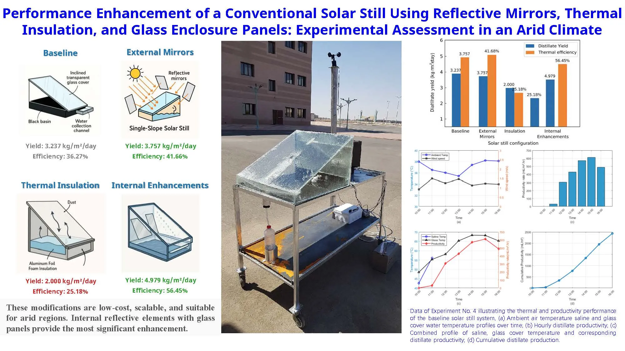
This study investigates the thermal performance and freshwater productivity of a passive single-slope solar still under four distinct configurations, aimed at enhancing distillation efficiency using low-cost modifications. The experiments were conducted in Tabuk, Saudi Arabia (28°23′50″ N, 36°34′44″ E), a region characterized by high solar irradiance ranging from 847 to 943 W/m2. The baseline system, constructed with a stainless-steel basin and inclined transparent glass cover, served as the control, achieving a cumulative distillate yield of 3.237 kg/m2/day and a thermal efficiency of 36.27%. Subsequent modifications included the addition of external reflective mirrors (Experiment 2), aluminum foil foam insulation (Experiment 3), and internal enhancements with side glass panels and internal aluminum mirrors (Experiment 4). Results demonstrated that the external mirror modification improved the distillate yield by 16% to 3.757 kg/m2/day, with a corresponding efficiency of 41.66%. However, insulation under dusty conditions led to a reduced yield of 2.000 kg/m2 and an efficiency of 25.18%, highlighting the critical influence of solar transmittance. The most notable improvement was recorded in the fourth configuration, which combined internal reflective elements and transparent side panels, resulting in a maximum yield of 4.979 kg/m2/day and thermal efficiency of 56.45%. These findings confirm that optical and thermal design enhancements can significantly augment the performance of passive solar stills, especially under high-irradiance, clear-sky conditions. The proposed modifications are low-cost, scalable, and suitable for implementation in remote and arid regions facing freshwater scarcity. This study offers valuable insights into the systematic optimization of solar distillation systems to improve sustainable water production.
Open Access
Communication
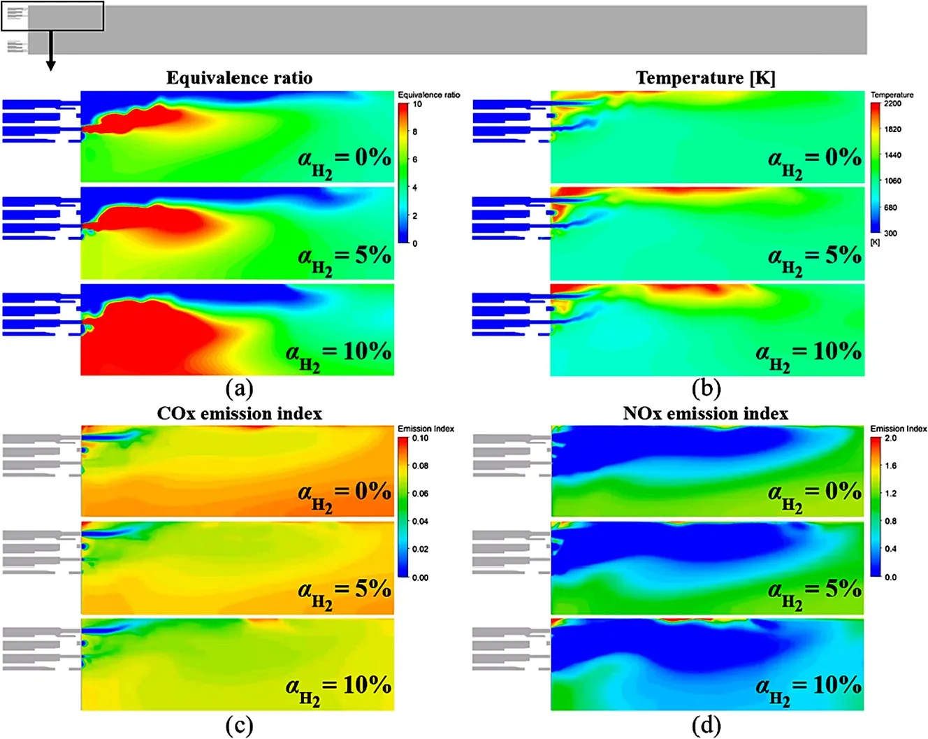
24 October 2025Investigating Potential PFAS Emissions from Initial Electrolyzer Operation
The fluoropolymers used in proton exchange membrane (PEM) water electrolysis are part of the broad OECD definition of per- and polyfluoroalkyl substances (PFAS), a family of substances subject to increasing regulation. Potential PFAS emissions during commercial operation have been investigated in PEM fuel cells, but have not been reported for PEM electrolyzers. Based on previous measurements of fluoride release rates in water, potential emissions of fluorinated substances are likely to be detectable during the onset of stack operation. This observation is extended to evaluating potential PFAS emissions by collecting and analyzing recirculated water samples from a multi-megawatt PEM electrolyser plant in the first ~2 weeks of operation. No PFAS substances were detected using U.S. EPA Method 1633, consistent with the lack of observed degradation based on cell voltage and fluoride measurements. Methodologies for selecting and handling water samples were established. Minimizing gas crossover and maintaining water quality during electrolyzer operation can mitigate potential chemical degradation via hydroxyl radical formation. Implementing dual uses of the reverse osmosis deionization system to provide water and wastewater treatment can increase closed-loop operation and minimize potential PFAS emissions from wastewater.
Open Access
Article
09 October 2025Preparation of CdS-BaZrO3 Heterojunction for Enhanced Photocatalytic Water-Splitting Hydrogen Production
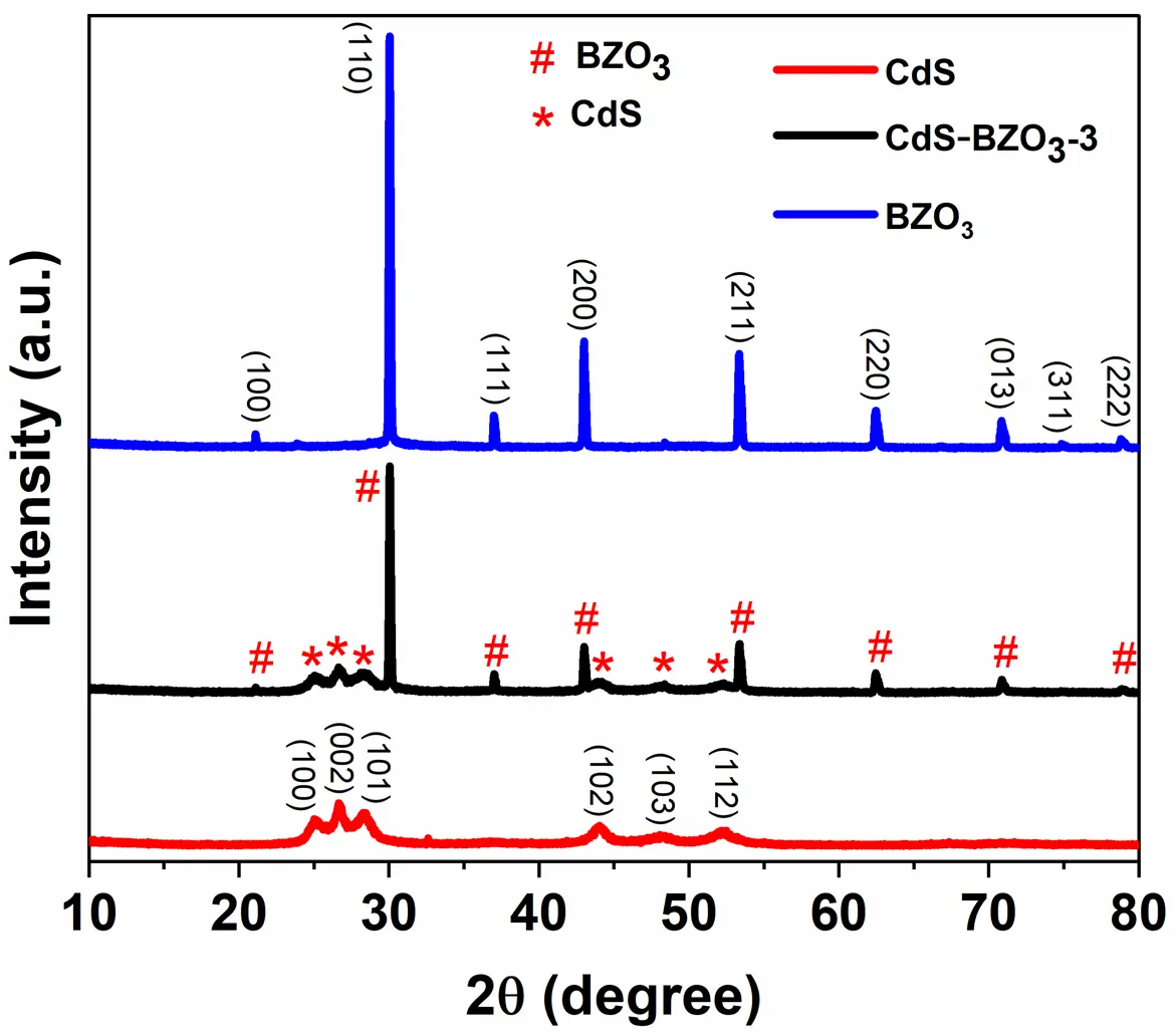
Photocatalytic water splitting using solar light, a promising technical approach for hydrogen production. However, the slow charge transfer and rapid recombination of photogenerated charge carriers in photocatalysis limit their practical application. To address these issues, in this work, we successfully prepared a novel CdS-BaZrO3 (CdS-BZO3) heterojunction via a simple chemical-bath deposition method. The as-prepared heterojunctions facilitate the separation and transportation of photogenerated charges, while also maintaining the high redox-oxid ation ability of the photocatalysts. As a result, CdS-BZO3 heterojunctions show enhanced photocatalytic water-splitting hydrogen production ability without a co-catalyst. Especially, the optimized CdS-BZO3 sample exhibits high photocatalytic activity with a hydrogen production rate of 44.77 μmol/h, which is 4.4 and 2.9 times higher than that of BZO3 and CdS, respectively. At the same time, the CdS-BZO3 heterojunction exhibits good stability in the photocatalytic hydrogen production cycle test. This work provides a reference for the heterostructure construction of perovskite-based photocatalysts to improve photocatalytic performance.
Open Access
Article
23 September 2025Side Chain Piperidinium Functionalized AEMs with an Ethylene Oxide Spacer for Improving Ion Conductivity and Alkaline Stability
In this work, grafting alkaline stable piperidinium cations via ethylene oxide (EO) spacers onto an aryl ether-free poly(oxindole terphenylene) backbone was adopted as a strategy for designing self-aggregating side chain AEMs with optimized alkaline stability. Aryl ether-free poly(oxindole terphenylene) backbones were synthesized via superacid-catalyzed step-growth polycondensation and were subsequently functionalized with either piperidinium containing hydrophilic, dipolar EO or hydrophobic alkyl spacer, aiming to explore the effect of side chain-engineering on conductivity and alkaline stability of the resulting AEMs. The AEM membrane containing dipolar ethylene oxide spacer, despite its lower ion exchange capacity (IEC), exhibited a more pronounced microphase separated morphology as evidenced by TEM, and higher ionic conductivity (reaching up to 30.5 mS cm−1 at 80 °C) compared to the hydrophobic alkyl spacer-containing AEM membrane. This was attributed to its higher water uptake stemming from the EO hydrophilic nature and the formation of interconnected ion-conducting channels due to piperidinium–EO interactions. Additionally, the hydrophilic nature of the ethylene oxide groups endowed the membrane with enhanced alkaline stability, preserving its mechanical integrity and retaining 71.5% of its initial conductivity after 3 weeks of immersion in 2 M KOH at 80 °C. In contrast, the AEM with an alkyl spacer experienced severe degradation under the same conditions. These results suggest that incorporating flexible alkoxy-containing spacers onto an aryl ether-free backbone is a promising and simple route for fabricating mechanically and chemically robust AEMs with sufficient conductivity.

Open Access
Article
23 September 2025Techno-Economic Evaluation of Vegetated Swales for Urban Stormwater Management in South Australia
Urban stormwater runoff continues to challenge cities worldwide due to increasing impervious surfaces and intensified rainfall from climate change. Swales—vegetated conveyance channels designed to manage runoff volume and quality—offer a nature-based solution that integrates hydrological function, ecological enhancement, and cost-effectiveness. This study investigates the performance and lifecycle economics of swale systems using a case study in South Australia. A MUSICX model simulation was conducted to quantify pollutant removal and flow reduction, and lifecycle costing was performed to evaluate construction and annual maintenance requirements. Results indicate exceptionally high treatment efficiencies, with over 99% removal of total suspended solids, nitrogen, phosphorus, and gross pollutants, and a 99.09% reduction in runoff volume. The total capital cost of the swale network was estimated at $19,726.50, with annual maintenance at $6157.49. Economic benefits from pollutant removal and avoided downstream treatment were valued at $14,874 per year, demonstrating a favorable benefit-cost profile. The findings underscore the potential of well-designed swales to function as cost-effective, modular components of decentralized stormwater management systems. These results contribute evidence supporting the broader integration of swales into urban planning, particularly in water-sensitive design frameworks seeking to achieve sustainability, climate adaptation, and SDG-aligned outcomes.

Open Access
Article
08 September 2025Open Water in Winter: An Influential but Underestimated Ecosystem in Northern Boreal Mountain Regions
Patches of open water (polynyas) persist throughout six-month winters on many ice-covered lakes in boreal mountain ecoregions of northwestern North America. We explored their distribution, hydrological correlates, and the diversity of species using them from freeze-up to break-up. In headwater drainages, lakes with outflow polynyas were significantly larger than those without, but many small lakes also had polynyas. There was a consistent threshold in upstream catchment size below which outflow polynyas were absent and above which they persistently occurred in downstream lakes. Outflow polynyas depend on winter-long through-flow of water, likely maintained by the hydraulic head of higher elevation ground water in perched water tables in this region of very limited permafrost. Based on camera trapping, two species, the American dipper and river otter, used polynyas heavily throughout winter foraging. Polynyas likely provided crucial forage for at least 9 species of migratory waterfowl (Anatidae) to complete their spring migration or to prepare for reproduction on local lakes. Cameras recorded additional 5 bird and 11 mammal species, as foragers, scavengers, or incidentally. We report previously undocumented significance of these spatially-limited and seasonal polynya ecosystems in expanding the diversity of winter ecological opportunity for numerous species on small to medium-sized lakes.


Open Access
Review
21 July 2025Fuel Oil Combustion Pollution and Hydrogen-Water Blending Technologies for Emission Mitigation: Current Advancements and Future Challenges
In recent years, researchers have focused on exploring alternative fuel technologies that enhance engine performance and combustion efficiency while reducing nitrogen oxide (NOx) and particulate matter (PM) emissions. Water-diesel emulsified fuel, which requires no engine modifications, has emerged as a critical pathway for cleaner diesel engine applications. This review systematically examines the combustion characteristics, emission performance, and energy efficiency of emulsified fuels in compression ignition (CI) engines. Studies indicate that compared to conventional pure diesel, emulsified fuels significantly optimize combustion processes through micro-explosion phenomena, shorten ignition delays, and improve combustion efficiency. Notably, NOx and PM emissions are simultaneously reduced, effectively resolving the traditional trade-off dilemma between pollutant reduction targets. Emulsified fuel exhibits comparable power output and fuel consumption rates to those of pure diesel, while delivering enhanced environmental benefits. Additionally, innovative technologies such as hydrogen nanobubbles further enhance combustion dynamics by improving fuel atomization and radical generation, though challenges persist in stabilizing non-aqueous nanobubbles and scaling up production. Despite ongoing advancements in policy incentives (e.g., green hydrogen subsidies) and combustion mechanism research, industrial adoption of emulsified fuels still faces technical hurdles, including equipment corrosion and issues with long-term storage stability issues. In conclusion, water-based emulsified fuels and hydrogen-water blending technologies provide efficient and low-cost transitional solutions for reducing diesel engine emissions, with their multi-component synergistic optimization mechanisms laying a theoretical and practical foundation for future clean fuel development.
Open Access
Review
11 July 2025Feasibility of Accessing Safe Water in Developing Countries Using Photocatalytic Technology—A Review
Access to clean drinking water is a global concern. Notably, over one billion people in developing countries out of a total global population of approximately eight billion encounter challenges in accessing safe water. Photocatalytic technology is a potential solution for providing safe drinking water to these communities. However, only a few photocatalytic technologies are currently available. Although the potentialities of the photocatalytic treatment of water pollutants can be demonstrated in the laboratory, several factors hinder its effectiveness in real environmental applications. Additionally, the development of maintenance-free photocatalytic systems that can operate continuously without requiring complex maintenance is limited. Developing countries are unlikely to implement a system if it cannot be used sustainably without complex and/or frequent adjustments, regardless of the advanced technology. This principle is the fundamental premise of this review. This review in which are discusses the conditions necessary for photocatalytic water purification systems to be accepted in developing countries and explores how these systems can be successfully implemented.
Open Access
Article
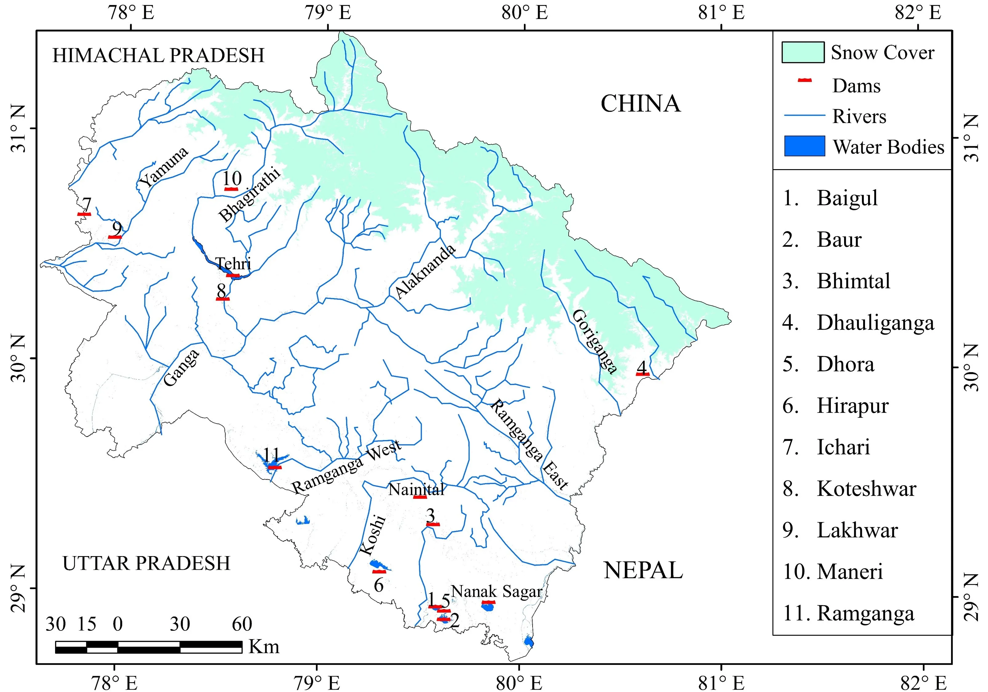
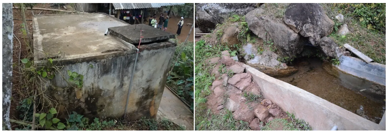
11 July 2025Water Resource Potential in the Indian Central Himalaya: A Study on Its Conservation through Traditional Practices
The Himalayan region, known as the water tower of the Asian continent, boasts plenty of water. However, it faces acute water scarcity, particularly during the dry months from February to June. Traditional water sources were once the primary source of water in rural areas, but many have dried up, and some have vanished entirely. This paper examines potential of water resource and its conservation through traditional water practices in the Indian Central Himalaya. The study employs mainly a qualitative approach, collecting data from both primary and secondary sources. Primary data were gathered from 34 natural springs, including Naula, Dhara, streams/rivulets, Guls, and Khal-Chals, through a case study of 10 villages in the Pindar Valley. Furthermore, the characteristics and uses of these natural springs were illustrated. A total of 120 heads of households were interviewed about the status of water and its future potential, addressing perceptions of water availability, usage patterns, and water scarcity. The perception of these heads of households on the impact of climate change was noted. The author studied toposheets of the Survey of India and described the major rivers of the 13 districts of Uttarakhand. Data were also collected from the review of literature and the state water resource department, Dehradun. The study revealed that rural areas face acute water scarcity due to the drying of natural water sources. The tap water supply is insufficient, and during the rainy season, these pipelines are often damaged by flash floods and landslides. Large-scale sedimentation in the source area of tap water further hinders the water supply. The study suggests that reviving traditional natural water sources will help sustain water availability and supply.