1. Introduction
Water is a fundamental resource essential for life and a key driver of economic and social development. The Earth holds 71% of its area under water in the form of oceans, seas, bays, gulfs, glaciers, rivers, lakes, ponds, and groundwater. Out of the total water cover, 73% is oceanic water, which is generally not useful, except in some areas such as Saudi Arabia [
1] where oceanic water is purified for drinking. The remaining 3% of water is found as glaciers and inland water bodies, and most of this proportion is inaccessible. The World Meteorological Organization (WMO) stated that only 0.5% of the water on Earth is usable and available as freshwater [
2]. Furthermore, water availability varies worldwide, ranging from equatorial regions to temperate, cold, and desert regions. It also varies seasonally and annually, with variability found in both quantity and quality. Keeping its importance in mind, the United Nations (UN) encompasses water as Sustainable Development Goal (SDG) 6, which aims to ensure the availability and sustainable management of water and sanitation for all.
The world population is growing fast, leading to unprecedented pressure on water resources. According to the World Bank, the world is expected to face a 40% shortfall in water by 2030 [
3]. Approximately two billion people in the world do not have access to safe drinking water, and half of the population is experiencing severe water scarcity as mentioned by the Intergovernmental Panel for Climate Change [
4]. Approximately 5 billion people are expected to lack sufficient water by 2050 [
5]. The numbers are expected to increase in the future because of high population growth and climate change. Salinization of groundwater due to sea-level rise will decrease freshwater availability for humans and ecosystems in coastal areas. Water scarcity is expected to increase further due to global warming [
6]. The United Nations Development Program (UNDP) stated that the impact of climate change has made water vulnerable and less predictable [
7]. A holistic approach to integrated water resources management is essential, using both traditional and modern methods.
The Himalayan region is renowned as the Water Tower of Asia, containing half of the permanent snow and ice fields outside the polar regions. It is the home to numerous glacier-fed perennial rivers. The world’s largest three river systems–the Ganges, the Sindhu, and the Brahmaputra originate and flow in the Himalayan region. It encompasses 33,000 km
2 of glaciated basins and stores approximately 12,000 cubic km of freshwater, sustaining around 1.5 billion people of South Asia, including China [
8]. A total of 9,000 glaciers is found in the Himalaya [
9], along with numerous rivers, streams, and springs. Himalaya has nearly 17% area under permanent snow cover and 30–40% under seasonal snow cover [
10,
11]. The Himalayan rivers carry approximately 1,200,000 million m
3 water every year [
12,
13,
14].
Although it holds abundant water resources, its uses account for only 2% of the total potential. Studies depict that a total of 26,993 out of 39,142 (31%) inhabitants have proper water supply coverage [
15]. With the increase in population, water demand is growing at a 1% annual growth rate [
16]. Recently, the people of the Himalayan region have been facing acute water scarcity. Increasing need of water for food and energy, and rapid population rise further accentuated water scarcity in the region [
17,
18]. Water scarcity results in reduced crop production, decreased hydropower generation, and food insecurity [
19]. It is always linked to socio-economic vulnerability [
20,
21]. NITI Ayog et al. [
22] observed that the Himalayan region has lost half of its perennial springs, and many springs have become seasonal. Some of the Himalayan hill towns, such as Kathmandu [
23], Darjeeling, Mussoorie, Shimla, Thimphu, and Kabul, are facing water scarcity [
24].
The agricultural sector consumes 75% of the total water demand. Water scarcity can have adverse impacts on cattle and agricultural farming, with long-term effects on the environment and climate [
25]. Proper water usage could enable farmers to grow a variety of crops, enhancing their income and potentially reducing migration from the hills of the Central Himalaya. Water resource management is a challenging task in the Central Himalaya due to diverse landscapes and unique challenges and opportunities.
The rapid depletion of freshwater is becoming an increasing global concern [
26]. Furthermore, the demand of fresh water is rising due to population growth and increasing need for water for domestic use, irrigation, and industrial sectors [
27,
28]. This region receives huge rainwater mainly during the four months of the monsoon season with annual average rainfall is 240 cm. However, a big proportion of it runs off. Conservation of water through rainwater harvesting and groundwater recharge may lead to an adequate water supply. In the Himalayan region, water scarcity is acute in the hill terrain and near the settlement areas, mainly during the dry season [
29,
30,
31]. Hilly terrain and geological hazards are the potential challenges for identifying suitable sites for constructing a water reservoir [
32].
The Central Himalaya is grappling with the problem of glacier retreat, primarily attributed to climate change. This phenomenon, coupled with degradation in water quality due to rapid urbanization and industrialization, has led to a decline in the availability of freshwater. Groundwater availability and recharging in the Himalayan region are limited due to its steep and precipitous terrain and high runoff of rainwater. Other challenges include inadequate infrastructure, poorly planned hydropower projects, vulnerable communities, limited monitoring data, and global warming. At the local level, it is said that water and youth from the hills drain to the plain regions, and as a result, hill regions are facing water scarcity, and plains are enjoying an abundance of water. Another problem related to water availability is that human concentration is the highest in the middle altitudes, whereas rivers flow in the valleys. Furthermore, the middle altitudes have a high slope gradient, which hinders water holding capacity. This leads to huge water scarcity. Water resource management in the Himalaya is crucial and inevitable, mainly for adequate irrigation, flood management, ample water supply, hydropower generation, and industrial development [
33,
34,
35]. Involvement of organizations and community members can help in managing water resources sustainably. Himalayan glaciers are highly vulnerable to climate change, with their impact observed to be higher than the average global change, thus significantly affecting water resources. Long-term conservation of natural springs and streams in the Himalaya is imperative for the sustainable availability of freshwater [
36].
The author reviewed some important works conducted on water resources management by scholars. Hurst [
37] studied the transformative shift of hydrology with high variability of natural processes. Hurst-Kolmogorov dynamics is directly related to high uncertainty and persistence of water resources. Similarly, Pizarro et al. [
38] provide a comprehensive overview of the past, present, and future trends in Hurst-Kolmogorov dynamics research, and highlight its contribution to the scientific literature of water resources. Pant et al. [
39] studied the Spatiotemporal variations of hydro geochemistry and its controlling factors in the Gandaki River Basin, Central Himalaya, Nepal.
The study raised two main research questions: (1) What are the major sources of water in the Himalayan region, (2) what are the traditional methods of water conservation? and (3) how can these water sources be utilized to provide a proper water supply in both on and off seasons? The primary objectives of this study are to assess the potential of water resources, analyze usage patterns from both traditional methods and modern water supply systems, and propose comprehensive policy measures for the sustainable use of water resources in this region of abundance and scarcity. The study hypothesizes that rejuvenating traditional natural water sources will sustain the water supply and help mitigate the impacts of climate change.
2. Study Area
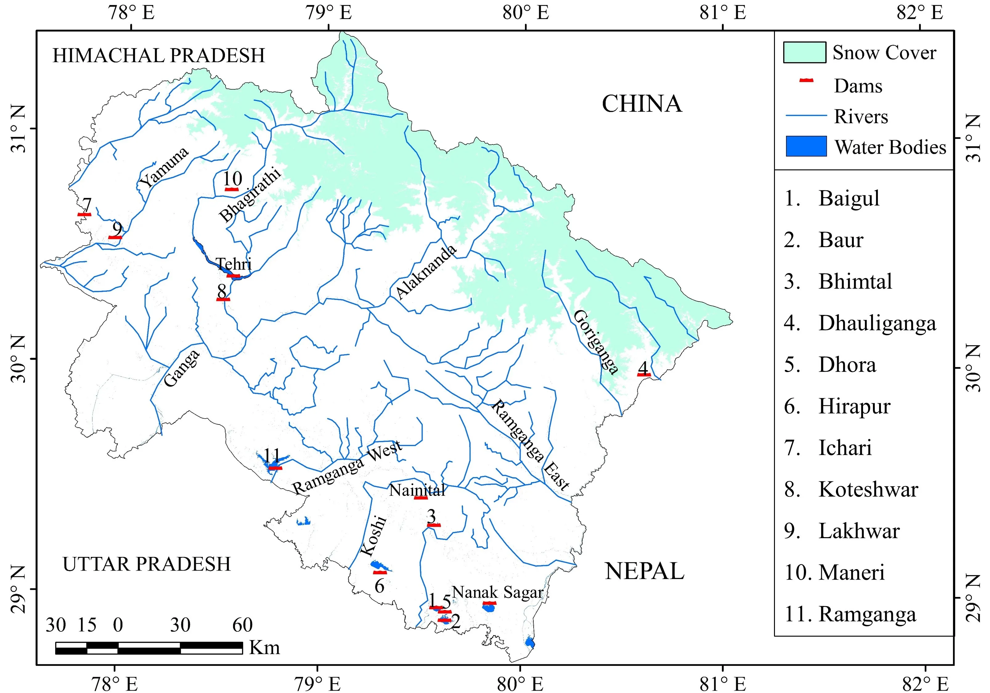
The Indian Central Himalaya, known as the Uttarakhand Himalaya, is a crucial component of the Himalayan Mountain system, comprising two distinct geographical and cultural entities–the Garhwal and Kumaon Himalayas. This region boasts numerous rivers and lakes, and covers approximately 20% of the snow area (). Most of its rivers are glacier-fed and perennial, with many spring/rain-fed rivers also maintaining perennial flows. The Ganges System is one of the largest river systems in the world, which is further divided into Yamuna-Tons and Bhagirathi-Alaknanda basins. This abundance of water resources is further evidenced by the average annual precipitation between 1981 and 2010, which ranged from 1500 to 3000 mm [
40]. Uttarakhand exhibits two distinct hydrogeological regimes–the Gangetic alluvial plain and the Himalayan Mountain belt, as identified by the Central Ground Water Board. While the Gangetic alluvial plain facilitates groundwater development due to its conducive characteristics, the hilly terrain of the Himalayan region limits groundwater availability, resulting in water scarcity in mountainous areas compared to plains. The Indian Central Himalaya boasts multiple water sources, including 17 major rivers characterized by high volume and velocity year-round, numerous snow-fed glaciers, and 31 significant lakes. Traditional water sources such as Naula, Dhara, streams/rivulets, guls, and Khal/Chals play prominent roles. However, the uneven distribution of water resources leads to water scarcity in many districts. The agricultural sector alone accounts for 75% of the total water demand in the region.
. Major water resources–glaciers, rivers, and water bodies in the Indian Central Himalaya.
3. Methodology
This study employed mainly qualitative methodology, gathering data from primary sources, interviews, field observations, and secondary sources–literature review and the state water resource management department. The author studied 34 natural springs of 10 villages across the Pindar River valley, assessing their potential to supply water to rural communities seasonally and daily, and examining how their availability is affected by climate change. These springs and villages of the middle catchment of the Pindar River were selected because this region is highly influenced by climate change-driven dryness and outmigration. Traditional water sources in these villages include Naula, Dhara, stream/rivulets, Guls, and Khals/Chals. The study also evaluated government-sponsored schemes for supplying water through taps, assessing their feasibility. The author interviewed 120 heads of households of 10 villages and obtained their perception on climate change impact on the traditional water sources in the rural areas. Their perception about the conservation of traditional water sources was obtained. The traditional water sources were defined and their characteristics and uses were described. The toposheets of the Survey of India were studied to know the major rivers of all thirteen districts of the state. Data on the major rivers and their annual discharge, the number of glaciers in each river catchment, and their area and volume; as well as hydropower and irrigation projects, were collected from the state water management department. The collected data underwent analysis using statistical tools and were interpreted using maps and graphs. Ranks were given to the annual average water discharge of each river. Furthermore, statistical analysis of the glacier data across four major river basins was carried out.
4. Results
4.1. Rivers as the Major Source of Water
The intricate river system of the Indian Central Himalaya is indeed fascinating, serving as a lifeline for both rural and urban communities (). The river systems provide a clearer picture of the region’s hydrology, with each sub-system contributing its own set of tributaries, thereby enriching the overall network. It’s interesting to note the distinction between glacier-fed and spring/rain-fed rivers, as this impacts not only the volume and velocity but also the reliability of water supply throughout the year. This diversity in water sources underscores the region’s resilience to fluctuations in weather patterns. The presence of multiple rivers in each district highlights the importance of water management and resource allocation at the local level. Moreover, the variation in volume and velocity among different rivers underscores the need for tailored approaches to harnessing their potential for irrigation and hydropower generation.
The existence of dual rivers such as Ramganga E & W adds another layer of complexity to the region’s hydrology, necessitating a nuanced understanding of their characteristics and behaviors. The ongoing construction of hydropower projects reflects the region’s potential for sustainable energy generation, although it’s essential to balance this development with environmental conservation and the needs of local communities. Overall, the Central Himalaya’s River system is not only a vital resource for the region’s inhabitants but also a dynamic ecosystem that warrants careful management and stewardship.
.
District-wise major rivers of Uttarakhand.
| S. No. |
District |
Major Rivers/Tributaries |
Total Number |
| 1 |
Almora |
Kosi, Ramganga, Suyal, and Gagas |
4 |
| 2 |
Bageshwar |
Saryu, Gomati, and Pindar |
3 |
| 3 |
Chamoli * |
Saraswati River, Alaknanda (Vishnu Ganga), Dhauliganga, Nandakini, Pindar, and Ramganga |
6 |
| 4 |
Champawat |
Saryu and Kali/Sharda |
2 |
| 5 |
Dehradun |
Asan, Song, Tons, and Rispana |
4 |
| 6 |
Haridwar |
Ganga and Solani |
2 |
| 7 |
Nainital * |
Kosi, Gola, Nandhaur, Dabka, Baur, and Bhakra |
6 |
| 8 |
Pauri |
Ganga, Alaknanda, and Nayar |
3 |
| 9 |
Pithoragarh |
Goriganga, Kali Ganga, Ramganga (E), Yangti, Dhauli (E), and Kuti |
5 |
| 10 |
Rudraprayag * |
Mandakini, Son Ganga, Kali Ganga, Saraswati River, Madhyamaheshwar, and Alaknanda |
6 |
| 11 |
Tehri |
Bhagirathi, Bhilangana, Alaknanda, and Ganga |
4 |
| 12 |
USN |
Sharda, Gola, and Phikka |
3 |
| 13 |
Uttarkashi * |
Bhagirathi, Yamuna, Rupin, Supin, Pabbar, and Tons |
6 |
4.2. Major Rivers and Their Annual Discharge
The Himalayan rivers are mainly snow-fed; therefore, they are perennial, and water discharge remains high throughout the year. In , rivers are arranged according to their annual average discharge from the lowest to the highest, and accordingly, a rank is given to each river in terms of their discharge. Out of a total of 16 rivers listed below, only four rivers are spring/rain-fed, although they are perennial. However, during the dry season (before the outbreak of the monsoon), the water level of these rivers declines considerably. In terms of annual average water discharge, the Ganga River ranks first. The Ganga River is formed after the confluence of two major rivers of the Indian Central Himalaya–the Bhagirathi and the Alaknanda, both of which are glacier-fed and have numerous perennial tributaries. The Kali River, which flows in the eastern part of the state, making a natural boundary between Uttarakhand and Nepal, is the second-largest river in terms of annual average discharge (420.700 m
3/s). Spring/rain-fed rivers such as the Ramganga, Kosi, Gomati, and Nayar rivers have comparatively low annual average discharges, although these rivers are perennial.
.
Major rivers and their annual discharge.
| River |
Annual Average Discharge (m3/s in Descending Order) |
Rank |
Source |
| Ganga |
656 |
First |
Glacier-fed |
| Kali River |
421 |
Second |
Glacier-fed |
| Alaknanda River |
287 |
Third |
Glacier-fed |
| Bhagirathi River |
246 |
Fourth |
Glacier-fed |
| Yamuna River |
220 |
Fifth |
Glacier-fed |
| Saryu River |
196 |
Sixth |
Glacier-fed |
| Goriganga |
169 |
Seventh |
Glacier-fed |
| Mandakini River |
105 |
Eighth |
Glacier-fed |
| Pindar River |
94 |
Nineth |
Glacier-fed |
| Dhauliganga (W) |
73 |
Tenth |
Glacier-fed |
| Nayar River |
33 |
Eleventh |
Rain-fed |
| Ramganga (E) |
20 |
Twelfth |
Glacier-fed |
| Gagas River |
15 |
Thirteenth |
Rain-fed |
| Kosi River |
9 |
Fourteenth |
Rain-fed |
| Tons River |
6 |
Fifteenth |
Glacier-fed |
| Ramganga |
5 |
Sixteenth |
Rain-fed |
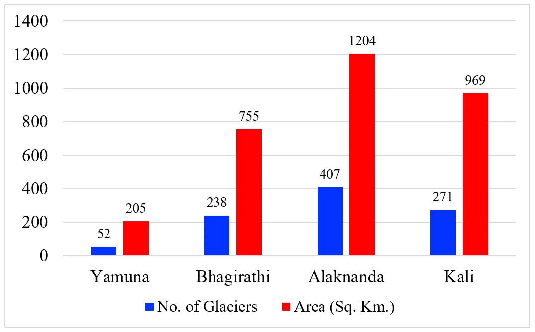
4.3. Area and Volume of Glaciers in the Indian Central Himalaya
The Indian Central Himalaya holds four large river basins where a total of 968 glaciers is located. These glaciers cover an area of 3133 km
2 with a volume of 213.74 km
3. The highest number of glaciers are located in the Alaknanda basin, followed by the Kali basin, and the Bhagirathi basin. The lowest number of glaciers was noted in the Yamuna basin. Accordingly, the area of glaciers varies from 1204 km
2, the highest, to 205 km
2, the lowest. The volume of glaciers also ranges from 12.20 km
3 to 90.75 km
3 (
). All the glaciers are located at an altitude of over 4000 m. Some of the largest glaciers in the Indian Central Himalaya are Yamunotri, Gangotri (Gaumukh), Bhagirathi Bank (Alkapuri glacier), Chaurabari, Nandaghunti, Pindari, Namik, and Milam.
.
Major river basin, number of glaciers, and their area and volume, 2021.
| Major River Basin |
No. of Glaciers |
Area (km2) |
Volume (km2) |
Snout Elevation (m) |
| Yamuna |
52 |
205 |
12.20 km2 |
4040 |
| Bhagirathi |
238 |
755 |
67.02 |
4150 |
| Alaknanda |
407 |
1204 |
90.75 |
4240 |
| Kali |
271 |
969 |
43.77 |
4130 |
| Total |
968 |
3133 |
213.74 |
4040–4240 |
shows that mean values reflect average glacier characteristics across the basins. Variance indicates variability; high variance in area and volume suggests large differences between basins. Skewness values show: moderate left-skew for glacier count, area, and volume (negative skew) and snout elevation is symmetric (skewness = 0). Excess kurtosis is positive for most variables, suggesting light tails (less outliers), except for volume which shows slight platykurtic behaviour (flatter than a normal distribution).
.
Statistical analysis of the glacier data across four major river basins.
| Statistic |
No. of Glaciers |
Area (km2) |
Volume (km3) |
Snout Elevation (m) |
| Mean |
242.00 |
783.25 |
53.44 |
4140 |
| Variance |
21,394.00 |
182,234.92 |
1123.57 |
6733.33 |
| Skewness |
−0.50 |
−0.96 |
−0.29 |
0.00 |
| Kurtosis |
1.39 |
0.99 |
−0.63 |
1.21 |
The four major river basins of the Indian Central Himalaya contain a significant number of glaciers covering a vast area under snow (
). These river basins consist of numerous sub-basins with many snow-fed tributaries. The Ganges basin is further divided into four major sub-basins, with the Alaknanda being the largest, followed by the Kali, Bhagirathi, and Yamuna basins [
41]. The number of glaciers correlates with the area under glaciers, as it has been established that the higher the number of glaciers, the larger the area covered by glaciers. All these river basins have abundant water, leading to the construction of numerous hydropower projects, along their course.
. Number of glaciers and their area in each river basin, 2021.
Uttarakhand is renowned as the Urja (Energy) State, holding high potential for the construction of irrigation and hydropower projects [
42]. Since independence, policymakers have planned for the initiation of numerous river valley projects with the aim of generating electricity and irrigating agricultural land. There are over 200 river valley projects in various stages of development, with some already completed and others still under construction or in the proposal stage. A total of 15 major completed projects are described (
). These projects are dispersed across the state and are utilized for the generation of hydroelectricity and irrigation purposes. Some of the largest dam projects include Tehri, Lakhwar, Jamrani, and Ramganga, which have heights exceeding 100 m. The Tehri High Dam is recognized as Asia’s largest dam, capable of generating 5000 MW of electricity. These river valley projects play a significant role in water conservation efforts.
.
Hydropower and irrigation projects.
| Name |
Purpose |
River |
Length (m) |
Height (m) |
| Baigul Dam |
Irrigation |
Baigul and Sukhi |
15,300 |
13.7 |
| Baur |
Irrigation |
Kichha |
9500 |
17.98 |
| Bhimtal |
Irrigation |
Bhimtal |
137 |
16.16 |
| Dhauliganga |
Hydroelectric |
Dhauliganga |
315 |
56 |
| Dhora Dam |
Irrigation |
Kichha |
9610 |
14.63 |
| Hirapur Dam |
Irrigation |
Kichha |
7980 |
10.98 |
| Ichari Dam |
Hydroelectric |
Tons |
155 |
59.25 |
| Jamrani Dam |
Irrigation |
Gola |
465 |
130.6 |
| Koteshwar |
Hydroelectric |
Bhagirathi |
3005 |
97.5 |
| Lakhwar |
Hydroelectric/irrigation |
Yamuna |
451 |
204 |
| Maneri |
Hydroelectric |
Bhagirathi |
127 |
39 |
| Nanak Sagar |
Irrigation/Drinking |
Deoha River |
19,200 |
16.5 |
| Ramganga |
Hydroelectric/irrigation |
Ramganga |
630 |
127.5 |
| Tehri Dam |
Hydroelectric/irrigation |
Bhagirathi and Bhilangana |
575 |
260.5 |
| Tumaria |
Irrigation |
Phika |
10,000 |
15.29 |
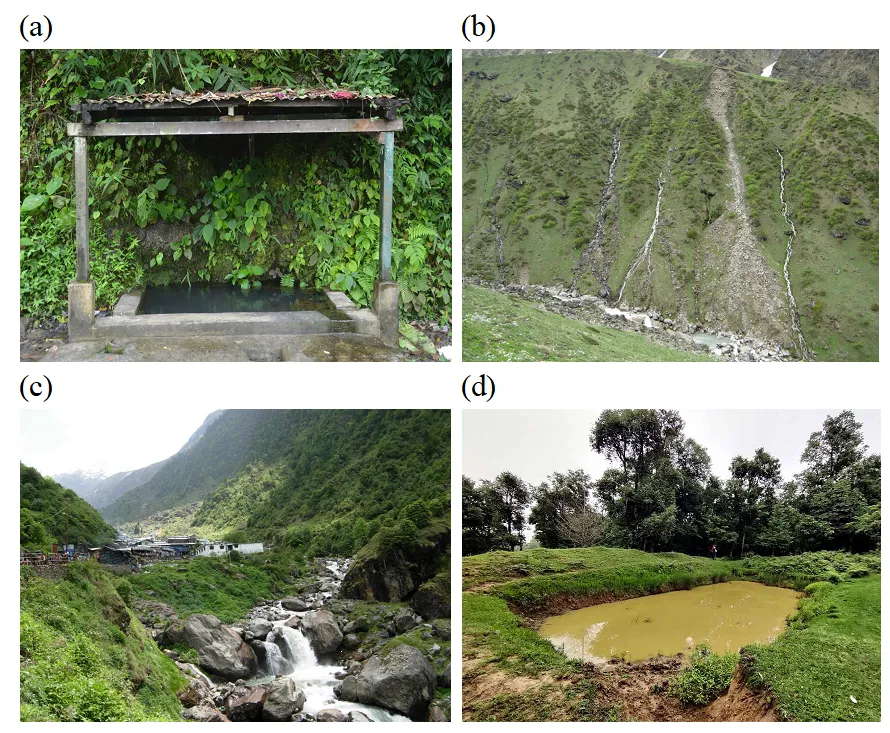
4.5. Traditional Practices of Water Conservation
The Indian Central Himalaya region is primarily characterized by rural settlements, where people rely on traditional water sources for drinking, irrigation, and other domestic purposes. Additionally, they also manage these water sources using traditional methods. Naula and Dhara, besides being sources of water, hold significant cultural and religious importance, serving as major centers for rituals and cultural activities. These sites are revered and worshipped on various occasions such as marriage ceremonies, the naming ceremony of a child (Namkaran), Yagyopaveet rituals, wedding ceremony, as well as during fairs and festivals [
43]. People in the region view water as a manifestation of Lord Vishnu.
The Indian Central Himalaya boasts numerous traditional sources of water, including Naula (small aquifers), Dhara (springs), Gadhera (streams–both perennial and seasonal), Guls (irrigation canals), and Khal and Chal (artificial ponds on hilltops). These sources serve as collection points and supply water to the communities. According to a study by the UNDP, approximately 2.6 lakh springs contribute to 90% of the drinking water sources in the Indian Central Himalayan region. The study further revealed that water discharge from 500 water supply sources, including springs, streams, and ponds, has decreased by 50%. Another study conducted by the water resource department indicated that 72% of women and 14% of children are responsible for fetching water on a daily basis, often having to walk distances ranging from 1 km to 4 km. During the dry season, when the water level remains very low in these spring-fed water sources, people often spend 2–3 h or more to fetch water. outlines the major water sources in the region, their characteristics, and their respective uses.
.
Name, characteristics, and uses of water sources in the Indian Central Himalaya.
| S. No. |
Name of Water Source |
Characteristics |
Uses |
| 1. |
Naula |
Naula serves as a deep aquifer and often resembles a temple in its structure, featuring a roof sloping on all four sides. These structures are typically found near settlements or amid farmlands. During the monsoon season, Naulas are inundated due to high water recharge, providing an ample water supply. However, during the dry season, particularly in March and April, the water in Naulas tends to dry up, leading to acute water scarcity, especially when no other water sources are available in the village. In many rural areas, Naulas are abandoned due to various reasons, such as the abandonment of farmlands and encroachment in the surrounding areas. |
Major source of drinking water |
| 2. |
Dhara |
Dhara is a continuous flow of freshwater spring that primarily fulfils the water needs of the people. In many rural areas, Dharas also serve as the primary source of irrigation water. Dharas typically occur where sloping ground intersects with impermeable strata, allowing groundwater to surface. The source of Dhara is aquifers, and it often takes on a pipe-shaped structure. |
Major source of drinking and irrigation |
| 3. |
Streams/Rivulets |
Streams or rivulets, locally known as Gad and Gadhera, are fed by natural springs and rainwater. Generally, these streams are perennial, providing a continuous flow of water. However, the quality of water near rural settlements tends to be polluted due to various factors. Despite this, people still use the water from these streams for irrigating kitchen gardens and farmlands along their courses. |
Streams are the sources of drinking water, as well as fpr animal, and irrigation use. |
| 4. |
Guls |
Guls are small canals constructed using mud and stones. Given the delicate landscape of the Indian Central Himalaya, traditional canal construction methods are often not suitable. Therefore, Guls are well-fitted to the fragile terrain, providing an effective means of water distribution without causing significant environmental disruption. |
Gula are used for irrigation, drinking, and for domestic uses. |
| 5. |
Khal-Chals |
Khal-Chals are manmade large depressions in mountainous areas utilized for rainwater harvesting. These structures collect ample water during the monsoon and winter seasons when precipitation is abundant. However, during the summer months, Khal-Chals typically remain dry as there is less rainfall and higher evaporation rates. |
Water is used for animals and for recharging groundwater. |
Naula, Dhara, Guls, and streams/rivulets are natural sources of water, nourished by springs, rainwater, and glaciers. On the other hand, Khal-Chals are artificial water sources. Khal-Chals are typically constructed in community lands or jungle areas and rely solely on rainwater, particularly during the monsoon season, for replenishment. Guls, on the other hand, derive their water from streams and rivulets. In the Indian Central Himalayan region, traditional water sources are abundant, as depicted in
.
. Traditional water sources (<b>a</b>) Naula, (<b>b</b>) Dhara, (<b>c</b>) Streams/rivulets, and (<b>d</b>) Khal and Chal; Source: Photo by Author.
A case study was conducted on 10 villages located in the Pindar River basin (
). These villages are situated at different altitudes and feature diverse landscapes. Traditional water sources such as Naula, Dhara, Streams, and Guls are present in each village, ensuring a water supply for the inhabitants. However, since these sources are spring-fed, water levels tend to decrease during the summer season, leading to water scarcity issues in almost all villages. To address the increasing water demands resulting from population growth, the Water Resource Department of the State Government has facilitated the provision of water supply through tap water to both rural and urban settlements. Recently, tap water facilities have been made available in each village. However, during the monsoon season, the water pipeline often sustains damage due to heavy rainfall and the steep and fragile nature of the slopes. Guls and streams serve as major sources for irrigating crop lands in the region. However, this facility is not available in all villages, and land is only partially irrigated in some areas. Villages such as Chirkhoon, Ali, Pali, Bagoli, and Kewer utilize water for irrigation purposes on a partial basis.
.
Village-wise major water sources, their nature, and availability.
| Village |
Source of Water |
Nature and Availability |
Irrigation Facility |
| Naula |
Dhara |
Stream |
Tap |
Gul |
| Chirkhun |
|
2 |
|
4 |
|
Dhara, being perennial, typically maintains a continuous flow of water throughout the year. However, its quantity may reduce during the summer months due to decreased rainfall and higher evaporation rates. While tap water is available in the villages, occasional water scarcity may still prevail due to the occasional breakage of tap water lines, particularly during heavy rainfall or other adverse weather conditions. |
Partially irrigated |
| Prethi |
2 |
|
|
4 |
|
Naula, being seasonal, tends to dry up during the summer months when rainfall is scarce. Although tap water is available in the villages, disruptions may occur during natural hazards such as heavy rainfall, landslides, or floods, leading to breakages in the water supply lines. |
Rainfed |
| Ali |
|
|
|
2 |
|
Tap water is available in the area; however, there are frequent occurrences of broken water lines, resulting in water scarcity issues. |
Partially irrigated |
| Kankhura |
|
|
1 |
1 |
|
The stream remains perennial, providing a continuous flow of water, but unfortunately, it is polluted. Despite the availability of tap water, frequent breakages in the water lines lead to water scarcity issues. |
Rainfed |
| Than |
|
|
|
2 |
1 |
Gul is perennial, seldom damaged due to heavy rain. Water is distributed through tap water.
The Gul is perennial, ensuring a consistent water supply, and it is rarely damaged by heavy rainfall. Water distribution is facilitated through tap water systems.
|
Partially irrigated |
| Keshpur |
1 |
1 |
|
1 |
|
Both Naula and Dhara are perennial water sources, meaning they provide water throughout the year. However, during the summer months, their water levels tend to decrease due to reduced rainfall and higher temperatures. Recently, tap water has become available as an additional water source in the area. |
Rainfed |
| Leguna |
|
|
|
2 |
|
Limited water supply. |
Rainfed |
| Pali |
|
|
|
1 |
1 |
The Gul provides a consistent water supply as it is perennial. However, during heavy rainfall, there is a risk of the pipeline being washed away, leading to water scarcity issues in the area. |
Partially irrigated |
| Bagoli |
|
1 |
|
2 |
1 |
Both Dhara and Gul are perennial water sources, ensuring a continuous water supply. Additionally, tap water is available in the area, contributing to high water availability for the residents. |
Partially irrigated |
| Kewer |
1 |
|
|
2 |
1 |
Dhara and Gul are perennial. Tap water is available, and water availability is high. |
Partially irrigated |
4.7. People’s Perception on Water Scarcity and Conservation
The perception of people regarding water scarcity and conservation was documented through interviews with a total of 120 heads of from 10 villages in the Pindar River basin (
). A series of 12 major and 10 minor questions were posed to the respondents, including inquiries such as whether drinking and irrigation water is sufficient, the impact of climate change on water availability, and whether rain/roof water harvesting is practiced. Additionally, questions were asked about the adequacy of tap water supply, its potential contribution to sustainable water supply, and the possibility of reviving traditional water sources to enhance water availability. According to the findings derived from the perceptions of the participants, it was concluded that water supply is inadequate, irrigated land is scarce, climate change has a significant impact on water availability, rain/roof water harvesting practices are minimal, tap water supply is gradually improving, the revival of traditional water sources is essential, and factors such as land abandonment, outmigration, and encroachment contribute significantly to the drying of natural water sources.
.
People’s perception on water scarcity and conservation (n = 120).
| S. No. |
Questions |
Response (%) |
| Yes |
No |
| 1. |
Is water sufficient for your drinking and other domestic purposes? |
34 |
66 |
| 2. |
Do you irrigate your farmland? |
15 |
85 |
| 3. |
Do you think that water scarcity has been increasing? |
92 |
8 |
| 4. |
Do you know about climate change? |
76 |
24 |
| 5. |
Do you think that climate change is the most important factor for water scarcity? |
53 |
47 |
| 6. |
Do you harvest rain/roof water? |
10 |
90 |
| 7. |
Do you think that harvesting rain/roof water will conserve water? |
83 |
17 |
| 8. |
Do you use tap water? |
88 |
12 |
| 9. |
Do you think that a proper supply from tap water will sustain water supply? |
95 |
5 |
| 10. |
Can the revival of traditional water sources solve the problem of water scarcity? |
92 |
8 |
| 11. |
What are the major reasons of drying natural water sources?
(a) Climate change
(b) Erratic rainfall
(c) Land abandonment
(d) Outmigration
(e) Encroachment
|
67
68
46
39
54
|
33
32
54
61
46
|
| 12. |
What is your main source of water?
(a) Naula
(b) Dhara
(c) Stream/rivulet
(d) Gul
(e) Khal/Chal
|
42
47
38
25
5
|
58
53
62
75
95
|
5. Discussion
In spite of an abundance of water, in both rural and urban areas, the Indian Central Himalaya is facing acute water scarcity. The unsystematic distribution of water and poor management of water resources have led to this scarcity. In rural areas, the water supply system is insufficient to meet community needs. The high fragility of the landscape and frequent landslides damage water pipelines and other water-related infrastructure, mainly during the rainy season. In many areas, water quality is poor, especially during the monsoon season, when a high proportion of muddy water is supplied for drinking purposes. Changing patterns of snowmelt and rainfall further impact water quality. Rainwater does not percolate into the aquifers in the Himalayan region due to high runoff caused by steep and precipitous slopes; therefore, groundwater is not recharged. Furthermore, climate factors, anthropogenic causes (such as land abandonment and outmigration), topography, deforestation, soil degradation, and declining rainfall reduce water availability. Although, hydropower projects are important for electricity generation and an ample water supply, these are not suitable for the fragile landscape of the Indian Central Himalaya, mainly the large projects. Natural hazards are causing damage to water sources such as dam reservoirs (). Furthermore, due to huge dam reservoirs constructed for generating hydropower projects in the upstream regions, downstream ecosystems are disturbing and also causing water scarcity.
Communities in rural areas, mainly in the middle altitudes, depend fully on springs to meet their water needs, which dry up mainly during the four months of summer season–March to June before the onset of the monsoon. The author observed that many natural springs have dried up due to climate change [
44]. Abandonment of agricultural land due to large-scale outmigration is another reason for the drying of natural springs. The phenomenon is also attributed to modernization, loss of traditional knowledge systems, land use changes, forest fires [
45], and lack of maintenance of traditional water sources. Depletion of forests in the river catchment areas is causing a decrease in groundwater recharge. Pumping water from the river valleys to rural areas located in the middle altitudes is costly and energy-intensive. In the 1990s, the state government started lifting water from the river valleys to the middle altitude villages, however, due to high costs and lacking proper maintenance, the scheme was not successful. A study conducted by the State Climate Change wing depicts that the two districts–Pauri and Dehradun–are currently the most vulnerable due to limited surface water and declining groundwater availability. In addition, districts such as Almora, Pauri, Tehri, Pithoragarh, and Chamoli are facing a drinking water crisis [
46]. The inherent nature of the resource, land-use changes, lack of scientific understanding, and climate variability all make springs further vulnerable to extinction. The water crisis in the Pauri district is one of the reasons for large-scale outmigration [
47]. On the other hand, districts like Champawat and Bageshwar are relatively less vulnerable due to their abundance of water.
The Tata Water Mission reported that approximately 20% of the 15,165 villages are facing acute drinking water problems, and more than 180 villages do not have a proper source of drinking water in the Indian Central Himalayan region. The author observed that most of the non-glacial rivers in Uttarakhand are drying up; some of them are Kosi, Rispana, Song, Gomati, and Gola. These rivers are the source of water for the majority of the population in the hills. A study depicted that the lean annual flow of the Kosi River has decreased from 790 L per second in 1992 to 48 L per second in 2017. Nainital is facing the same problem. Due to encroachment in the surrounding areas of Nainital, a major source of drinking water, the recharge area has dried up. Furthermore, the water storage capacity has decreased, and the rate of sedimentation has increased. The Rispana River is another example facing a water pollution problem. The increasing number of slums along the river has created a water scarcity problem.
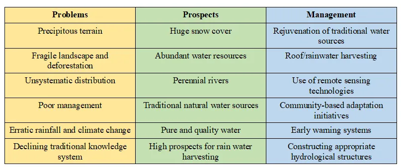
. Problems, prospects, and management of water resources in the Indian Central Himalaya.
The perception of 120 heads of households on depletion of traditional water sources and conservation strategies leads to a holistic approach that can enhance water sustainability in the Himalayan region. They further perceived that climate change is the major driver of the drying of these natural springs. Besides, there are many other factors affecting them. Due to exodus outmigration from the Indian Central Himalaya, agricultural land has been abandoned and thus, the rate of rainwater runoff has increased. Most of the natural springs lie in the agricultural land and thus, the rate of their recharge decreased significantly. Climate change impact on water resources and water pollution was noted as significant in the study area. High intensity and short duration of rainfall further caused the drying of natural springs. Based on the people’s perception, it was noted that the conservation of traditional natural springs will provide ample water and reduce water scarcity. Planting Banyan and Peepal trees near water sources is a common practice in the Himalaya. Some of the practices of conserving water include the construction of Khals and Chals in the forest area. These are artificial ponds constructed on the slopes of mountains to prevent soil erosion and maintain groundwater recharge. Further, these artificial ponds supply water for both domestic and wildlife animals. Therefore, these practices need to be further strengthened.
Water resource management is crucial in the Himalaya due to its significance as the source of major river systems that sustain millions downstream. The Himalayan glaciers are an important component of the hydrological system. However, these glaciers are retreating at an alarming rate due to climate change, posing challenges for water availability and agricultural practices in the region [
48]. Effective water resource management strategies must consider socio-economic and environmental factors, incorporating local communities’ knowledge and participation to ensure sustainability. The integration of remote sensing technologies for glacier monitoring and community-based adaptation initiatives is crucial in addressing the evolving water challenges in the Himalaya [
49]. The construction of small-scale (micro)-hydropower and irrigation projects is best suited to the fragile landscape and ecology [
50]. Plantation of trees according to the altitudes, such as mixed-oak forests in the temperate region, will restore ecology, conserve water, and control soil erosion. Thus, a holistic approach that combines scientific research, policy interventions, and community engagement is essential for the sustainable management of water resources in the Himalayan region.
6. Conclusions
The water resource potential in the Indian Central Himalaya is substantial. It has many glaciers, perennial rivers, lakes, dam reservoir, and traditional water sources. The total estimated volume of water in the Indian Central Himalaya is ~229.74 km3 and an additional 5–10 km3 storage capacity is needed by 2040 in Uttarakhand. Except for the traditional water sources, which include Naula, Dhara, Streams/rivulets, Gul, and Khal/Chal, the use of other major water sources is negligible, mainly in the rural areas. The reason is that the rural settlements lie in the middle altitudes, whereas the rivers and streams flow in the valley regions and due to terrain constraints and distance (precipitous slopes and undulating terrain), pumping of river water is not possible due to the long distance and undulating terrain. On the other hand, the traditional water sources supplied sufficient water to the rural people in the past. However, many water sources have recently dried up, and some have vanished. As estimated, more than 250 natural springs have been dried out in the past decades, indicating the prevalence of water scarcity, especially during the dry season of four months from March to June. People perception of drying natural water sources depicted that climate change, erratic rainfall, land abandonment, insufficient water sources, the distance of rivers from human settlements, outmigration, and encroachment are the major factors. The author also observed that due to climate change, the temperature increased and the rainfall decreased. This led to a decrease in the production and productivity of crops and therefore, people out-migrated to other parts of the country for better livelihood. This further resulted in land abandonment, which is the major factor of drying natural springs in the rural areas. A large number of people perceived that the water is not sufficient for daily use and water availability is decreasing, although approximately 35% of people in rual areas rely on traditional water sources. People suggested that roof/rain water harvesting, proper tap water supply, and conservation of traditional water sources will lead to sufficient water supply in rural areas. To revive the traditional sources of water, plantation in the catchment area, proper management of water sources through community participation, an early warning system, and tap water supply are the essential steps for sustainability. Furthermore, tap water supply can be ensured through its proper management.
Acknowledgements
The author would like to thank all those who assisted in conducting this work.
Ethics Statement
The author confirms that all the research meets ethical guidelines.
Informed Consent Statement
Not applicable.
Data Availability Statement
The datasets are not available.
Funding
The authors declare that no funding was received during this work.
Declaration of Competing Interest
The author declares no financial or non-financial interests exist that are directly or indirectly related to this work.
References
-
1.
Alnajdi O, Wu Y, Kaiser Calautit J. Toward a sustainable decentralized water supply: review of adsorption desorption desalination (ADD) and current technologies: Saudi Arabia (SA) as a case study.
Water 2020,
12, 1111.
[Google Scholar]
-
2.
World Meteorological Organization [WMO]. The State of the Climate in Asia 2022 Report; World Meteorological Organization: Geneva, Switzerland, 2022.
-
3.
World Bank. World Bank Group Water Global Practice; World Bank: Washington, DC, USA, 2022.
-
4.
Intergovernmental Panel on Climate Change. Climate Change 2007: Impacts, Adaptation and Vulnerability; Cambridge University Press: Cambridge, UK, 2022.
-
5.
UN Water. Nature‑Based Solutions for Water: The United Nations World Water Development Report 2018; UNESCO: Paris, France, 2018.
-
6.
Intergovernmental Panel on Climate Change. Climate Change 2022: Impacts, Adaptation, and Vulnerability (AR6 WGII Report); Cambridge University Press: Cambridge, UK, 2022.
-
7.
United Nations Development Programme [UNDP]. Reducing Disaster Risk: A Challenge for Development; UNDP Bureau for Crisis Prevention and Recovery: New York, NY, USA, 2004.
-
8.
Raina VK, Srivastava M. Glacier Atlas of India. 2008. Available online: https://toc.library.ethz.ch/objects/pdf/e04_81-85867-80-9_01.pdf (accessed on 10 July 2025).
-
9.
Negi AS, Joshi K. Drinking water issues and development of spring sanctuaries in a mountain watershed in the Indian Himalaya.
Mt. Res. Dev. 2002,
22, 29–31.
[Google Scholar]
-
10.
Joshi R, Kumar K, Palni LM. Dynamics of Climate Change and Water Resources of Northwestern Himalaya; Springer International Publishing: New York, NY, USA, 2015.
-
11.
Eriksson M, Chu XJ, Shrestha AB, Vaidya RA, Santosh Nepal SN, Sandström K. The Changing Himalayas: Impact of Climate Change on Water Resources and Livelihoods in the Greater Himalayas; International Centre for Integrated Mountain Development: Kathmandu, Nepal, 2009.
-
12.
Singh JS. Sustainable development of the Indian Himalayan region: Linking ecological and economic concerns.
Curr. Sci. 2006,
90, 784–788.
[Google Scholar]
-
13.
Negi SS. Natural Resource Management in the Himalaya. Vol. I: Land and Water Environmental Management; A.P.H. Publishing Corporation: New Delhi, India, 2023.
-
14.
Sharma S, Joshi R, Joshi R, Rawal RS, Dhyani PP. Progression in developmental planning for the Indian Himalayan Region. 2015. Available online: https://gbpihed.gov.in/PDF/Publication/Progression_developmental_planning_for_IHR.pdf. (accessed on 10 July 2025).
-
15.
UN–WWDR. United Nations World Water Distribution Report; UNESCO: Paris, France, 2018; p. 154.
-
16.
Liu X, Chen B. Climate warming in the Tibetan Plateau during recent decades.
Int. J. Climatol. 2000,
20, 1729–1742.
[Google Scholar]
-
17.
Banerjee S, Mukherjee A, Sattar A, Biswas B. Change detection of annual temperature and rainfall in Kalimpong station under hill zone of West Bengal.
Indian J. Hill Farming 2015,
28, 81–84.
[Google Scholar]
-
18.
Mukherji A, Molden D, Nepal S, Rasul G, Wagnon P. Himalayan waters at the crossroads: Issues and challenges.
Int. J. Water Resour. Dev. 2015,
31, 151–160.
[Google Scholar]
-
19.
Magadza CHD. Climate change impacts and human settlements in Africa: Prospects for adaptation.
Environ. Monit. Assess. 2000,
61, 193–205.
[Google Scholar]
-
20.
Huq N, Hugé J, Boon E, Gain AK. Climate change impacts in agricultural communities in rural areas of coastal Bangladesh: A tale of many stories.
Sustainability 2015,
7, 8438–8460.
[Google Scholar]
-
21.
Ramprasad V. Debt and vulnerability: Indebtedness, institutions and smallholder agriculture in South India.
J. Peasant. Stud. 2019,
46, 1286–1307.
[Google Scholar]
-
22.
NITI Aayog. Report of Working Group I: Inventory and Revival of Springs in the Himalayas for Water Security; Government of India: New Delhi, India, 2018.
-
23.
Pant RR, Bishwakarma K, Qaiser FU, Pathak L, Jayaswal G, Sapkota B, et al. Imprints of COVID‑19 lockdown on the surface water quality of Bagmati river basin, Nepal.
J. Environ. Manag. 2021,
289, 112522.
[Google Scholar]
-
24.
Snyder A. Shortage in the Mountains of Plenty: Water Supply in Mountain and Hill Cities Throughout the Hindu‑Kush Himalayan Region. Available online: https://www.worldfoodprize.org/documents/filelibrary/images/youth_programs/2014_interns/2014_br_research_papers/SnyderAbigail_LONGReport_56ED38F157B76.pdf. (accessed on 10 July 2025).
-
25.
National Research Council [NRC]. Water Resources Management in Uttarakhand; National Academies Press: Washington, DC, USA, 2000.
-
26.
Liu J, Yang H, Gosling SN, Kummu M, Flörke M, Pfister S, et al. Water scarcity assessments in the past, present, and future: Review on water scarcity assessment.
Earth’s Future 2017,
5, 545–559.
[Google Scholar]
-
27.
Dolan F, Lamontagne J, Link R, Hejazi M, Reed P, Edmonds J. Evaluating the economic impact of water scarcity in a changing world.
Nat. Commun. 2021,
12, 1915.
[Google Scholar]
-
28.
Rosa L, Chiarelli DD, Rulli MC, Dell’Angelo J, D’Odorico P. Global agricultural economic water scarcity.
Sci. Adv. 2020,
6, eaaz6031.
[Google Scholar]
-
29.
Das MM, Barfal SS, Joshi M, Joshi R, Kumar K, Kumar D. Review on water scarcity across Indian Himalayan Region. In Smart City: Computational and Experimental Techniques for Sustainable Urban Development; Bentham Science Publishers: Sharjah, United Arab Emirates, 2022; Volume 11, pp. 92–102.
-
30.
Gurung P, Sherpa TY. Freshwater scarcity and sustainable water management in the Hindu Kush–Himalayan (HKH) region.
Hydro Nepal J. Water Energy Environ. 2014,
15, 42–47.
[Google Scholar]
-
31.
Mondal TK, Roychowdhury P. Water scarcity in Himalayan hill town: A study of Darjeeling municipality, India. In Urban Drought: Emerging Water Challenges in Asia; Springer: New York, NY, USA, 2019. doi:10.1007/978-981-10-8947-3_21.
-
32.
Qin L, Bai X, Wang S, Zhou D, Li Y, Peng T, et al. Major problems and solutions on surface water resource utilization in karst mountainous areas.
Agric. Water Manag. 2015,
159, 55–65.
[Google Scholar]
-
33.
Rawat AS, Sah R. Traditional knowledge of water resource management in Kumaon Himalaya.
Indian J. Tradit. Knowl. 2009,
8, 249–254.
[Google Scholar]
-
34.
Sharma K, Kanwar P. Indigenous water conservation system—A rich tradition of rural Himachal Pradesh.
Indian J. Tradit. Knowl. 2009,
8, 570–573.
[Google Scholar]
-
35.
Khadse GK, Talkhande AV, Kelkar PS, Labhasetwar PK. Conservation, development and management of water resources: An experience in Himalayan region, India.
Int. Water Resour. Arid. Environ. 2011,
1, 193–199.
[Google Scholar]
-
36.
Akhtar M, Ahmad N, Booij MJ. The impact of climate change on the water resources of Hindukush–Karakorum–Himalaya region under different glacier coverage scenarios.
J. Hydrol. 2008,
335, 148–163.
[Google Scholar]
-
37.
Hurst HE. Long-term storage capacity of reservoirs.
Trans. Am. Soc. Civ. Eng. 1951,
116, 770–799.
[Google Scholar]
-
38.
Pizarro A, Acuña P, Dimitriadis P, Iliopoulou T, Koutsoyiannis D. Past, present, and future of the Hurst–Kolmogorov dynamics in Stochastics: A bibliometric analysis of the last 50 years in water resources.
J. Hydrol. 2024,
643, 132008.
[Google Scholar]
-
39.
Pant RR, Zhang F, Rehman FU, Wang G, Ye M, Zeng C, et al. Spatiotemporal variations of hydro geochemistry and its controlling factors in the Gandaki River Basin, Central Himalaya, Nepal.
Sci. Total Environ. 2018,
622, 770–782.
[Google Scholar]
-
40.
Indian Meteorological Department [IMD]. Climatological Data; Indian Meteorological Department: Dehradun, India, 2012.
-
41.
Sati VP. The Ganges: Cultural, Economic, and Environmental Significance; Springer: New York, NY, USA, 2021.
-
42.
Sati VP. Landscape vulnerability and rehabilitation issues: A study of hydropower projects in the Garhwal region, Himalaya.
Nat. Hazards 2014,
75, 2265–2278.
[Google Scholar]
-
43.
Sati VP. Uttarakhand: Society, Culture, and Pilgrimages; Today and Tomorrow’s Printers and Publishers: New Delhi, India, 2022.
-
44.
Sati VP. Climate change and socio‑ecological transformation in high mountains: An empirical study of Garhwal Himalaya.
Changes Adapt. Socio‑Ecol. Syst. 2015,
2, 45–56.
[Google Scholar]
-
45.
Sati VP. Forest fires in the Indian Central Himalaya: Major drivers, implications, and mitigation measures.
Environ. Hazards 2024,
23, 390–404.
[Google Scholar]
-
46.
Sharma S. Uttarakhand Facing Acute Water Crisis: TNN, UNDP Report; Times of India: New Delhi, India, 2018.
-
47.
Singh VK. Water crisis in Uttarakhand. In Research Foundation for Science, Technology and Ecology & National Commission for Women; GBPIHED Almora: Uttarakhand, India, 2016; pp. 27–55.
-
48.
Immerzeel WW, Lutz AF, Andrade M, Bahl A, Biemans H, Bolch T, et al. Importance and vulnerability of the world’s water towers.
Nature 2020,
577, 364–369.
[Google Scholar]
-
49.
Shrestha AB, Maharjan S, Bajracharya SR. ICIMOD’s glacier monitoring in the Hindu Kush Himalaya using remote sensing technologies.
Remote Sens. Appl. Soc. Environ. 2019,
15, 100214.
[Google Scholar]
-
50.
Sati VP. Socio‑economic and environmental impacts of Jamrani Irrigation Dam Project, Kumaon Himalaya, India.
Rural. Reg. Dev. 2025,
3, 10007.
[Google Scholar]