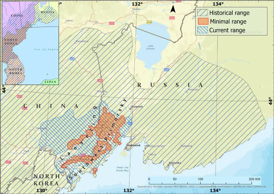
The last Far Eastern leopards survived at the junction of the Southwest of Primorsky Krai in Russia and the Laoyeling-Dalongling in Jilin and Heilongjiang provinces in China. By the year 2000, there were only 30–35 individuals living in an area of approximately 3000 km2. Thanks to conservation efforts, this endangered subspecies has moved away from the edge of extinction, with more than 150 individuals living in an area over 14,000 km2 in 2022. Reliable protection of key habitats has played a crucial role in this success. Over the past 25 years, the transboundary network of protected areas dedicated to the conservation of the Far Eastern leopard has increased 12 times, from 1532 km2 to 18,961 km2, covering 12,636 km2, or 90 percent of its current range. The latest step was the proclamation in 2024 of the Sino-Russian transboundary protected area “Land of Big Cats”. This includes the Kedrovaya Pad Nature Reserve, the Land of the Leopard National Park with a buffer zone in Russia (3694 km2), and the Northeast Tiger Leopard National Park in China (14,612 km2). According to our estimates, this will ensure the long-term preservation of 17,239 km2 of suitable habitats, which will allow for the maintenance of a potential population of at least 300 Far Eastern leopards.
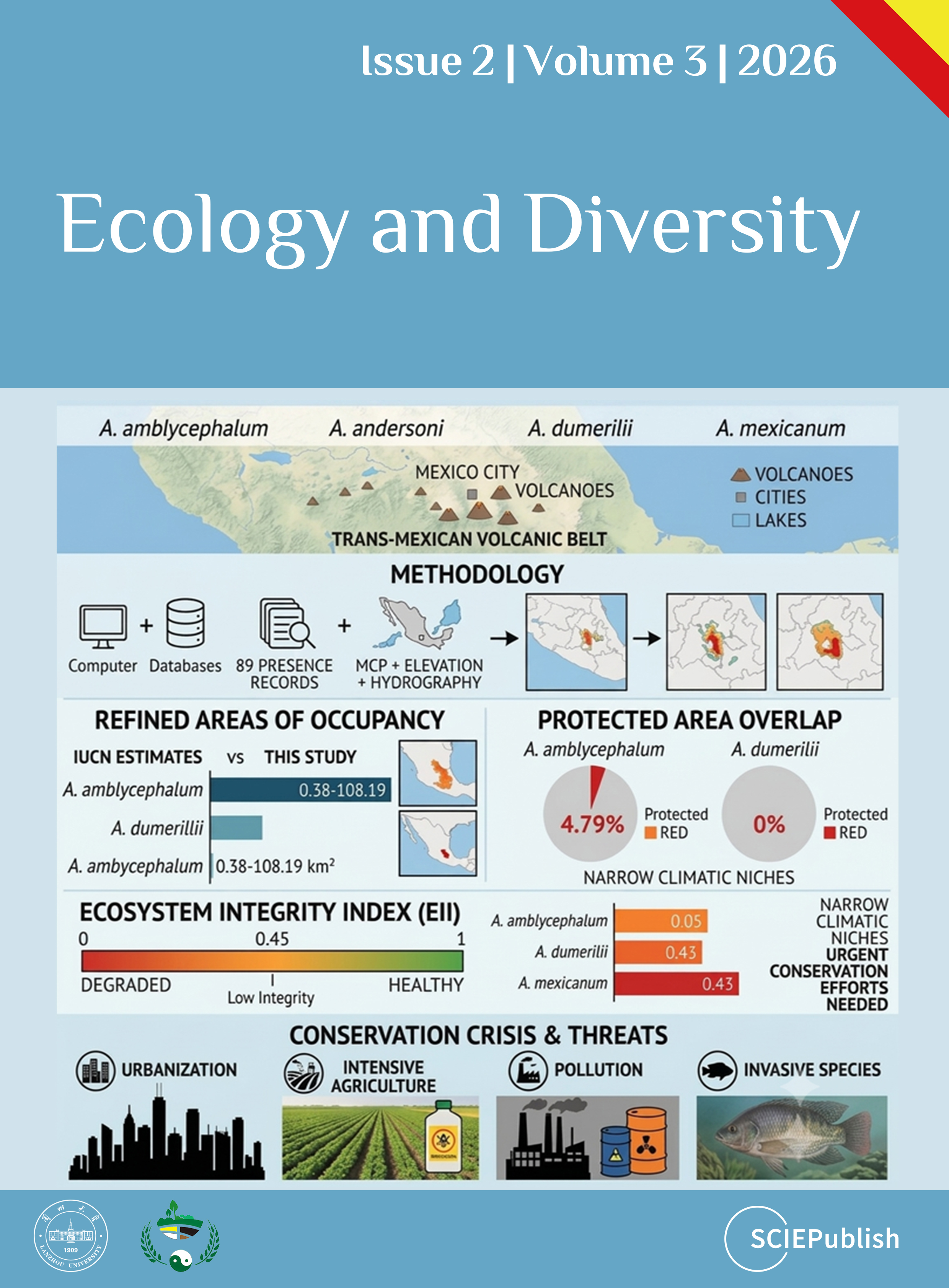
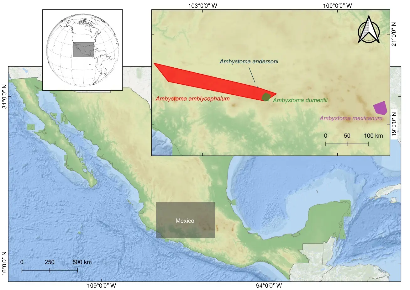
Salamanders of the genus Ambystoma in the Trans-Mexican Volcanic Belt are experiencing severe population declines due to habitat loss and fragmentation. This study evaluated critical protection gaps for four Critically Endangered microendemic species: A. amblycephalum, A. andersoni, A. dumerilii and A. mexicanum. We compiled and cleaned 89 validated presence records from databases and the literature. Refined areas of occupancy were calculated using minimum convex polygons adjusted with elevation masks, hydrographic network filters, and species-specific buffer zones (50–100 m). Bioclimatic variables (temperature and precipitation-based) were derived from MexHiResClimDB, and overlap with protected areas, and the Ecosystem Integrity Index (EII) was quantified. The resulting areas of occupancy (0.38–108.19 km2) were larger than previous IUCN estimates for A. amblycephalum and A. dumerilii, yet showed null or minimal overlap with protected areas for these two species (4.79% and 0%, respectively). Ecosystem integrity was low across all species (EII 0.05–0.43), indicating severe degradation. Climatic niches were narrow, differentiated, and associated with restricted altitudinal ranges. These results reveal a crisis of effective protection, where expanded distribution knowledge does not translate into improved conservation status, demanding urgent expansion of active conservation strategies to counteract severe habitat degradation caused by urbanization, intensive agriculture, pollution, and invasive species.
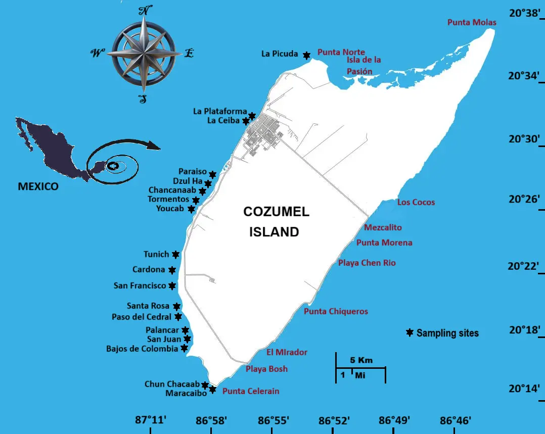
A common issue in defining marine protected areas is the often-vague boundaries, despite widespread GPS use. Identifying conservation zones varies but generally involves assessing species diversity, with choices based on ecological or economic value—usually at the manager’s discretion. This study suggests prioritizing areas with maximum diversity, focusing on six reef groups: hard and soft corals, macroalgae, sponges, hydrozoans, and anemones. Data from photo-transects and species collections at 18 sites in Cozumel’s marine park were analysed using geostatistical Kriging to delineate zones. The results highlight the southern part of the island as the most diverse and in need of protection.
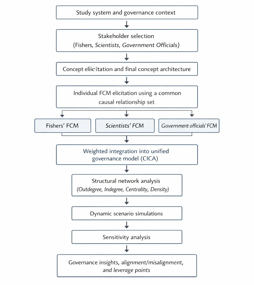
Understanding how governance systems respond to ecological complexity requires analytical approaches that capture both biophysical interactions and stakeholders’ interpretations of causal relationships within socio-ecological systems. In the Eastern Mediterranean, the Indo-Pacific pearl oyster, Pinctada radiata, poses a governance challenge because it is simultaneously perceived as a non-indigenous species, an ecosystem engineer, and a livelihood resource. This study develops the Causal Cognitive–Institutional Architecture (CICA) for marine governance. Using Fuzzy Cognitive Mapping (FCM), it formalises stakeholder reasoning and socio-economic interactions. Stakeholder-specific causal maps were constructed for fishers, scientists, and government officials. The resulting models reveal distinct but complementary causal logics: fishers emphasise stewardship, collaboration, and livelihood security; scientists prioritise ecological stability, environmental change sensitivity, and habitat impacts; and government officials primarily emphasise regulatory coherence and enforcement. These stakeholder-specific maps were then integrated into a unified governance model using a weighted linear fusion procedure. The unified FCM identifies collaboration, community education, and environmental change sensitivity as highly influential cross-domain concepts, while institutional trust emerges as a fragile but consequential governance variable. Scenario simulations indicate that interventions targeting collaborative and learning-oriented mechanisms generate broader stabilising responses across the system than enforcement-centred interventions alone. The CICA–FCM framework provides a transparent diagnostic approach for identifying governance bottlenecks, integrating heterogeneous stakeholder reasoning, and supporting adaptive management of P. radiata under ecological uncertainty.
The frequent failure of headstarting programs suggests we are overlooking important factors in amphibian reintroduction science. Since many repatriation efforts are in vain, such programs can become difficult to justify from a cost-benefit perspective (chronic failure also takes its toll on staff morale), ultimately working against the goals of conservation programs. The question of how to properly prepare amphibian larvae or juveniles for reintroduction and persistence in the landscape is of utmost importance. Here, we offer a previously unconsidered perspective that is predicated on the idea that amphibians, being vertebrates, have forebrain-based cognitive capabilities aligned along the nucleus accumbens-based reward system and the amygdaloid nuclei-based fear system. Experiences uploaded by the ventromedial pallium as memories are thought to be tagged as accumbens-based ‘good’ or amygdala-based ‘bad’, and stored as (relatively) long-term memories; as such, amphibians are said to be salient creatures. The necessarily nurturing nature of zoo husbandry protocols naturally works against young amphibians acquiring ecologically realistic life lessons, especially when these forebrain reward and fear circuits are developing. For example, in zoos, food provisioning eliminates the reward associated with searching for and then finding food, and the emphasis on survival in captivity means headstarted animals released into the wild have no opportunity to experience fear. Such under-stimulated reward/fear circuits poorly prepare headstarted animals for life in the wild. It follows that kindling this circuitry as it develops with ecologically relevant stimuli will better prepare animals for life following release into the wild. To the extent that realistic headstarting protocols call for sacrificing a few animals to enhance the experiences of the remaining many, they will no doubt be resisted by institutions. But we have two choices here: keep doing things the way we have been doing and expect different outcomes, or experiment with new ideas based on a broader understanding of these animals—ideas such as these we are now proposing—to improve the success of repatriation efforts.