Found 13 results
Open Access
Review
31 March 2026Metallic Iron, (Rain)Water, and the City: A Handout for Researchers and Policymakers
This study aims to promote residential rainwater harvesting everywhere rain falls. It recalls the history of urban rainwater (stormwater) management while insisting on the origin of the perception that rainwater is not a relevant source of potable water. It also argues that where rainwater is polluted, it can be easily treated using frugal technologies such as filtration on metallic iron-based filters. The study notes that stormwater is precipitation that is not harvested. Thus, harvesting rainwater prevents (quantitative) stormwater generation, and transforms stormwater from a threat (e.g., erosion, floods) to a resource (e.g., drinking water, food security) for human and environmental needs. The effective management of stormwater (i) enhances the quality of human life, (ii) sustains local biodiversity, and (iii) protects the whole environment. Thus, the failure to harvest rainwater should be considered irresponsible, if not unethical. This argument alone makes each conscientious citizen a changemaker. A number of local changemakers will organize to determine the best way to integrate overflow from individual residences to enhance the community’s liveability. This study provides a valuable consolidation of information that will facilitate the mainstreaming of rainwater harvesting as the pillar of holistic integrated water resource management.
Open Access
Article
24 March 2026Comparing Drone and Satellite DEMs for Hydrodynamic Flood Modeling in a Rural Brazilian Catchment
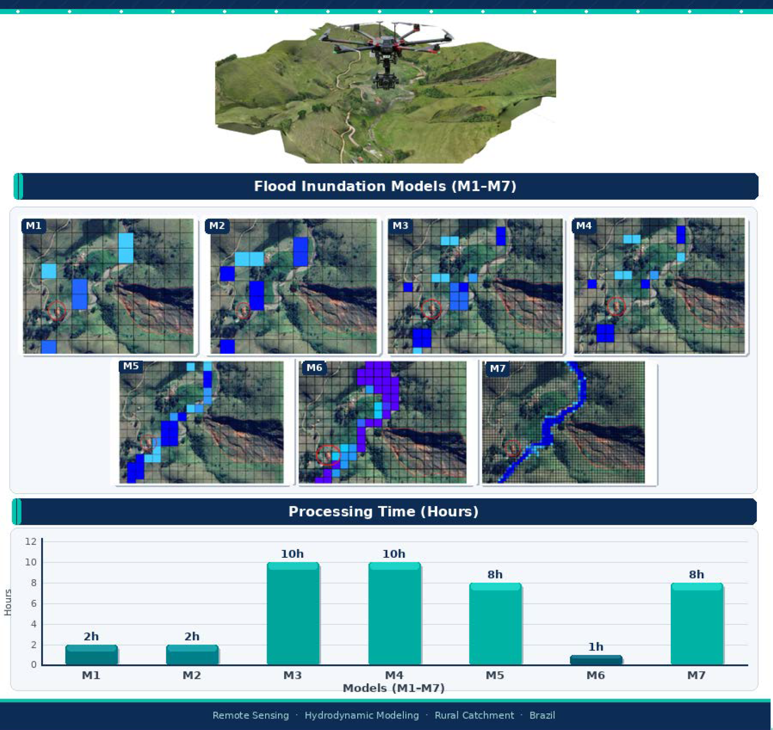
The rural region of the municipality of Bananal (SP, Brazil) experiences recurrent flooding events associated with rising water levels in tributaries of the Bananal River, especially during periods of intense rainfall. This study aimed to compare the performance of different Digital Elevation Models (DEMs), one derived from NASA orbital data and another generated from drone-based aerophotogrammetric surveys, in identifying and mapping flood-prone areas. The objective was to assess whether drone field campaigns are essential for this type of analysis or whether orbital DEMs are sufficient for the hydrodynamic characterization of the area. Hydrodynamic models were developed using the software QGIS, HidroFlu—for watershed parametrization and inflow estimation, and MODCEL—for hydrodynamic simulation, with spatial resolutions of 10 m, 30 m, and 50 m, in order to analyze the impact of topographic detail on simulation results. Two approaches were tested for defining boundary conditions: one based on precipitation data with a 25-year return period, and another based on the Bananal River discharge estimated from the watershed. The results indicated that the model based on the drone-derived DEM, with 10 m resolution and boundary conditions defined by river discharge, showed the best performance in representing floodable areas. However, the findings also highlight that high-resolution DEMs entail higher operational costs, due to the need for field activities and greater computational capacity to run the simulations.
Open Access
Article
23 September 2025Promoting Sustainable Development through Community Education on Flood- and Storm-Resistant Architecture
Pakistan is experiencing climate-induced disasters such as floods and storms with an increased frequency and intensity every single year. This study aims to explore the integration of resilient architecture into environmental education as a pathway toward sustainable development and disaster risk reduction. The research examines current levels of understanding regarding flood- and storm-resistant building practices and identifies key barriers to their adoption in high-risk regions of Pakistan. The study used a mixed-methods approach by administering surveys. These surveys were administered to 500 community members in different cities of Sindh and Punjab. The study also incorporated two in-depth case studies: the Heritage Foundation’s low-cost housing initiative in Makli, Sindh, and the Aga Khan Agency for Habitat’s Safe Housing Program in Chitral, Khyber Pakhtunkhwa. These cases provide valuable insights into effective, culturally appropriate, and scalable models of resilient construction in Pakistan. Findings of the present study reveal that public awareness of resilient architecture is below a satisfactory level, with common misconceptions. Challenges, including high costs, lack of technical knowledge, and minimal government support, were identified as significant obstacles. Despite these issues, communities showed strong interest in learning about safer building practices when exposed to practical examples and local success stories. The study recommends integrating resilient construction education into community outreach, school curricula, and builder training programs. It also advocates for greater government involvement, financial incentives, and replication of proven models to foster widespread adoption of resilient architecture for long-term sustainability.

Open Access
Article
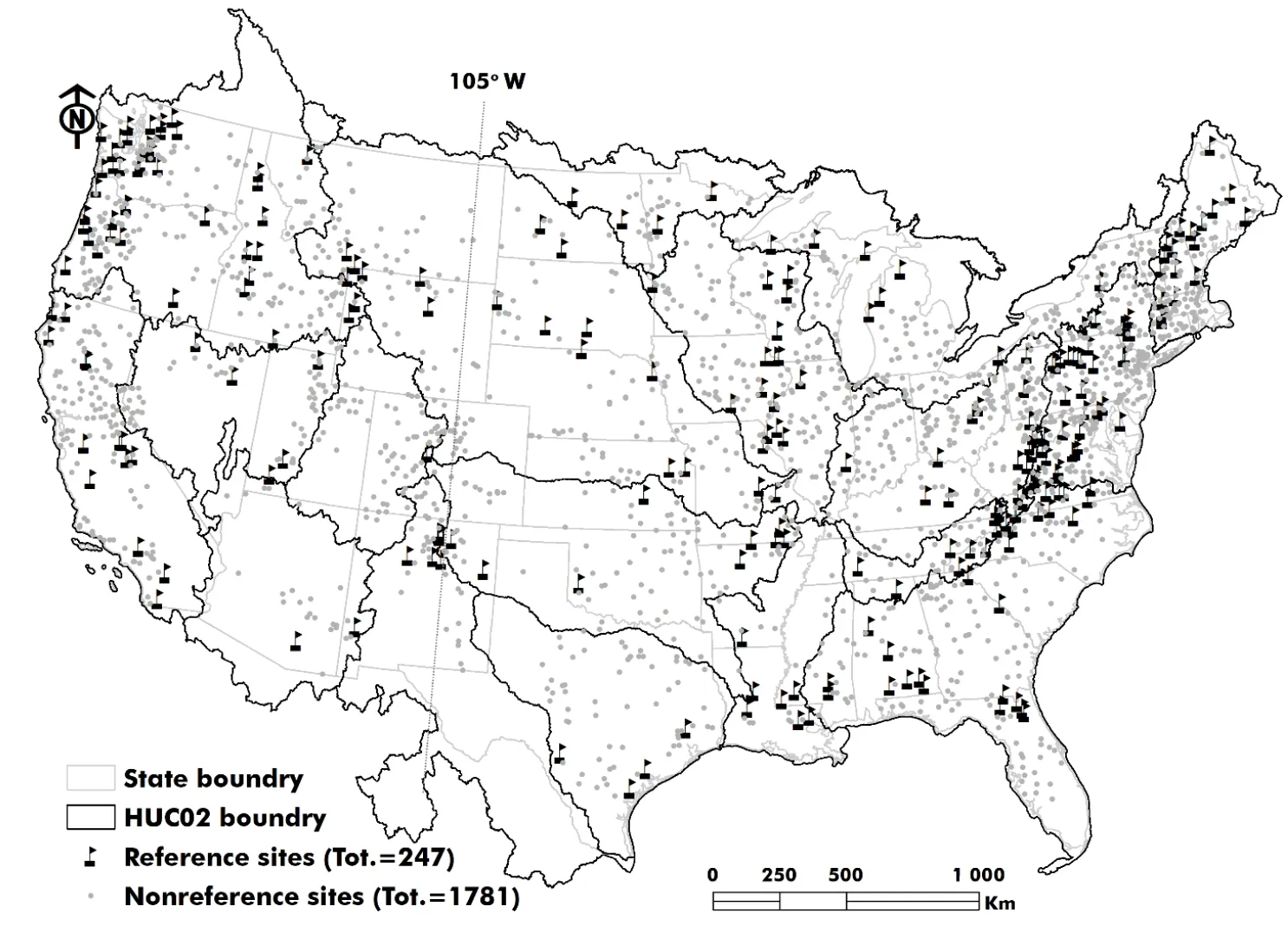
31 July 2025Single Shift Segmentation Improves Moderate Flood Estimates under Nonstationary Conditions across the United States
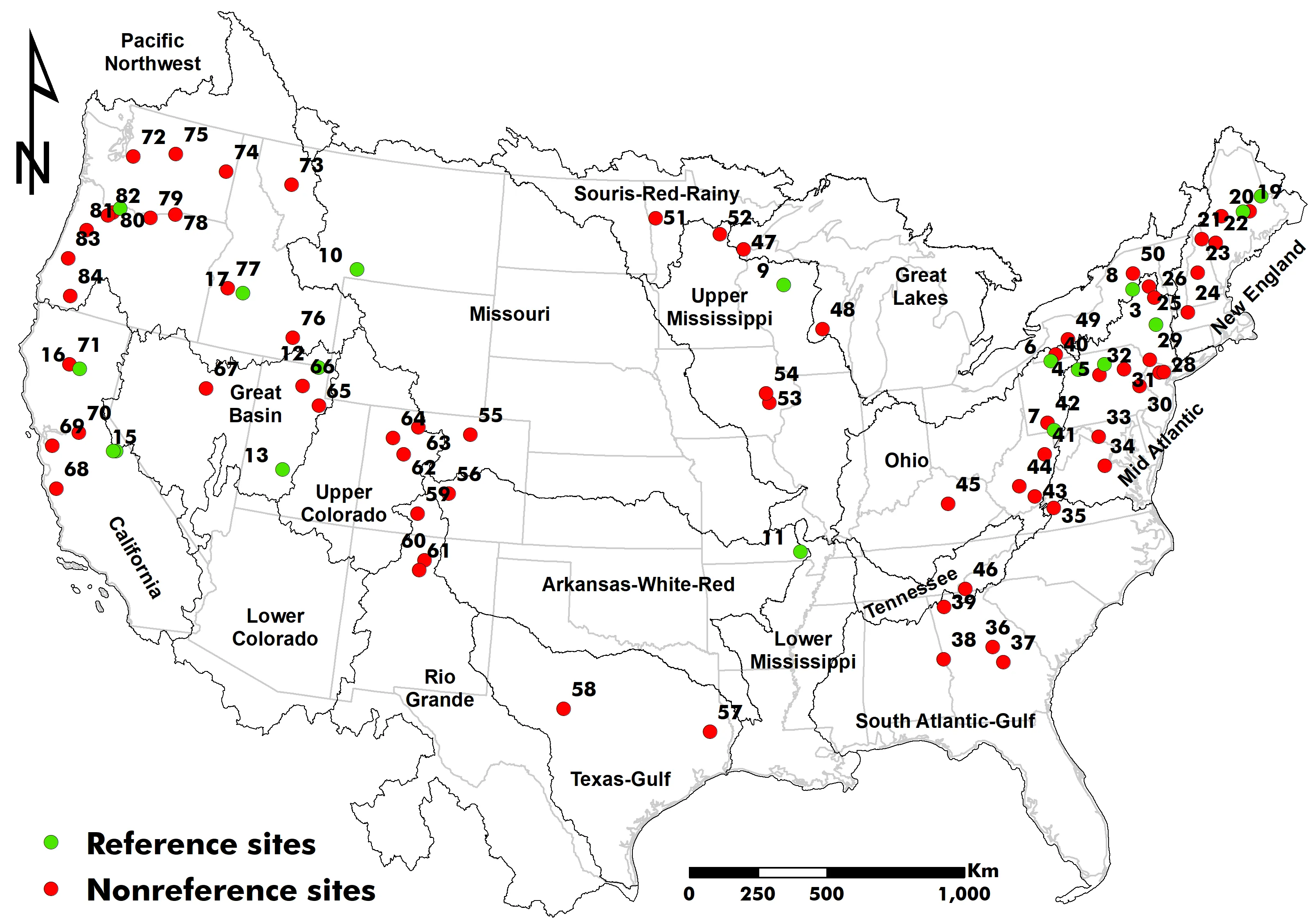
Precipitation, particularly at high quantiles, has been reported to increase in various regions across the globe, raising pluvial flood risk. One of the main challenges in reliable flood frequency analysis is handling nonstationarity arising from climate variability or anthropogenic disturbances such as land use/cover change or river regulation. To separate these nonstationary footprints, we analyzed annual maximum peak flow records from 18 reference (minimally disturbed) and 66 non-reference stream gages, each with more than 100 years of flood records across the United States. Next, we used a nonparametric Pettitt test to identify statistically significant change points. When present, the flood record was split into pre- and post-change segments with a Log-Pearson III distribution fitted to each. Depending on the region and site type, using a segmented record improved the quantile estimate. At the majority of reference sites, post-change data produced the highest flood quantiles, reflecting recent climate-driven nonstationarity. Conversely, at several non-reference sites, pre-change data returned larger estimates, indicating that long-standing anthropogenic disturbances can attenuate the signal of climatic variations. Our study confirms that fitting a flood frequency model to the segment that minimizes nonstationarity, rather than the entire record, returns more reliable estimates for moderate flood magnitudes of up to a 25-year return interval. The approach highlights the need to understand the population from which flood records are extracted, to separate those populations where appropriate, and then fit a statistical distribution. This practical approach offers a simple thought process for updating moderate flood forecasts to guide infrastructure design or rehabilitation in the current dynamic environment, an era of constant change that needs flexibility in everything we design.
Open Access
Article
28 May 2025A Framework for Watershed Flood Resilience in the Context of Climate Change: Concept, Assessment, and Application
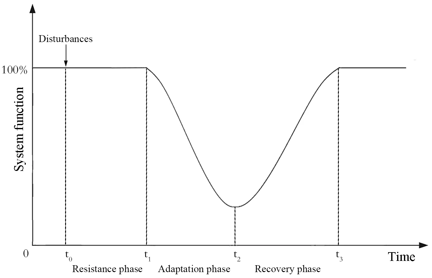
Extreme flooding events are increasing in frequency and severity due to climate change, challenging the effectiveness of traditional, infrastructure-centric flood management strategies. A key gap remains in the lack of spatially explicit and process-based frameworks for assessing and enhancing flood resilience at the watershed scale, which hinders the development of integrated and adaptive management solutions. This study proposes a conceptual framework for evaluating watershed flood resilience (WFR) by integrating resilience theory with the “source-flow-sink” paradigm from landscape ecology. It applies it to the post-disaster reconstruction of the Sishui River Basin following the 2021 Zhengzhou flood in China. The framework quantifies WFR through pre-event resistance capacity and intra-event adaptive capacity using hydrological modeling and loss curves. It systematically analyzes the effects of targeted interventions across source, flow, and sink areas. The results demonstrate that the proposed approach significantly improves WFR in the Sishui River Basin, with source interventions generally outperforming flow and sink interventions in the simulated cases, and compensatory effects observed among different intervention types. The findings confirm the operational feasibility and effectiveness of the proposed framework, including nature-based solutions and spatial planning in watershed management, which could provide support for future holistic and adaptive flood resilience strategies addressing climate change.
Open Access
Article
08 May 2025Vulnerability Assessment of Food Crop Production and Climate Change: Implication for Agricultural Productivity and Development in Nigeria
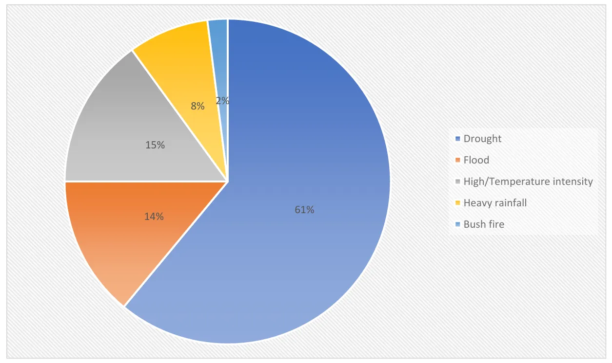
Climate change poses significant challenges to agriculture, particularly in developing nations like Nigeria, where the sector is highly dependent on vulnerable rain-fed farming systems. Extreme weather events such as prolonged droughts, erratic rainfall, flooding, and rising temperatures threaten agricultural productivity, food security, and rural livelihoods. This study examines the vulnerability of food crops to climate change, focusing on smallholder farmers’ perceptions and adaptation strategies. Using a multistage sampling technique, data were collected from 480 smallholder farmers across selected agro-ecological zones in Nigeria. The study employed descriptive statistics and a crop vulnerability scale to assess the susceptibility of key food crops—maize, cassava, sorghum, rice, millet, soybean, and yam—to climate extremes. Findings reveal that drought is the most critical climate-induced stressor affecting food crops, with maize and cassava exhibiting the highest vulnerability indices. Flooding also presents a substantial risk, particularly to maize, while temperature fluctuations have relatively less severe immediate impacts. The study highlights the importance of climate information dissemination, cooperative memberships, and extension services in enhancing farmers’ resilience. However, limited access to climate information remains a significant barrier to adaptation. Given the observed variability in crop vulnerability, it is recommended to implement targeted climate adaptation strategies such as drought-resistant crop varieties, improved drainage systems, and early warning mechanisms. This study underscores the urgent need for climate-smart agricultural policies and resilience-building measures to safeguard food production and rural livelihoods in Nigeria amid escalating climate change threats.
Open Access
Article
06 February 2025Performance Impacts of Rainwater Tanks on Stormwater Drainage Systems
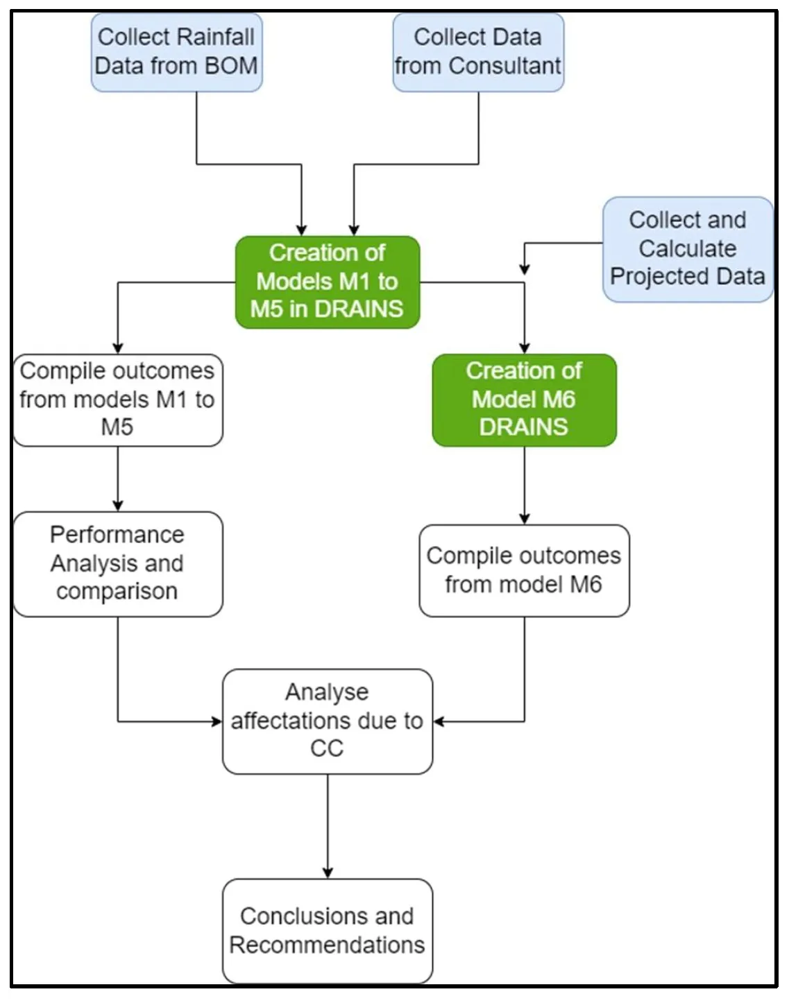
This article explores the impact of using rainwater tanks on the performance of a stormwater drainage system and the possible challenges posed by climate change and future rainfall projections. This project examines a residential development in Aldinga, South Australia. The study sets clear research objectives that include the creation and simulation of drainage systems with different conditions (e.g., with and without rainwater tanks, historical data, and projected data). The aim is to analyze performance changes in the drainage network after the inclusion of rainwater tanks. Furthermore, the incorporation of projected rainfall data is considered to study possible implications of climate change on the system performance. The methodology follows a quantitative approach, with data collection, creating different models with the use of software, and simulating various conditions such as storms with different annual exceedance probabilities and varying proportions of roof area connected to rainwater tanks. Several findings are identified in this project. When roof areas of all residential allotments are connected to rainwater tanks, substantial benefits are observed in reducing peak flows within the network and runoff volumes. This proportion of connected roof area is directly correlated with reductions in peak flow. Also, while the use of projected rainfall data slightly affects benefits in peak flow and volume reduction, they will remain relatively high at least until 2050. Other performance features, such as hydraulic gradient line, long sections, and time to peak, are also explored. Study validates the hypothesis that rainwater tanks have a significant impact on runoff reductions and flood management, particularly when 100% of roof area is connected with rainwater tanks. Also, there is an impact when projected data is used, but it remains manageable and should be considered under specific contexts to decide whether these impacts are significant. Several opportunities for future research are suggested. These include the examination of larger areas, projections to a more distant future, the use of different rainfall patterns, and the consideration of extreme rainfall events.
Open Access
Review
14 January 2025A Review of Phosphorous in Fluvial Floodplains: Source or Sink?
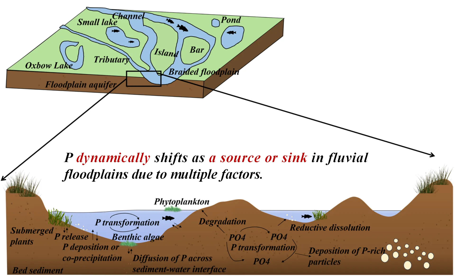
Fluvial floodplains are water-land transitional zones, playing an important role in hydrological and ecological systems. To date, the phosphorus migration and transformation in floodplain sediments remain elusive, which poses a large effect on river nutrient levels and primary productivity. This review summarized the sedimentary characteristics of floodplains and analyzed the spatial differences and temporal variations in phosphorus distribution. We further analyzed their potential change in floodplains under various conditions, determining the sedimentation and mineralization process of phosphorus. Meanwhile, phosphorus in the sediment will experience dynamic fluctuation as a source or sink of fluvial floodplains based on varying factors, including hydrological conditions, climate variations, biological activity, and pedological characteristics. In particular, the productivity and community population in floodplains, like vegetation and fishes, will be primarily associated with the periodic changes in phosphorus through food chain. Lastly, this review provided corresponding perspectives on improving the phosphorus administration in river floodplains based on existing problems. In total, it is anticipated that it will enhance the understanding of phosphorus resources or sink in the fluvial floodplains, contributing to the stability of aquatic ecosystems.
Open Access
Article
25 November 2024Partial Duration Series of Wet and Dry Years Can Improve Flood Estimates in the Context of a Nonstationary Climate and Anthropogenic Disturbances
Accurately estimating flood levels is essential for effective infrastructure design, reservoir management, and flood risk mapping. Traditional methods for predicting these levels often rely on annual maximum flood (AMF) data, which may not always fit well to statistical models. To improve these estimates, we tested an approach that considers floods in relation to annual climate conditions—specifically, average, wet, and dry years—using daily streamflow data. We examined how well the Log Pearson Type III (LP3) distribution, a commonly used statistical model in flood frequency analysis, estimates flood levels when applied to these customized datasets instead of standard AMF data. Our study included over 70 years of data from 2028 basins across the United States, with drainage areas ranging from small (4.0 km2) to large (50,362 km2). We found that in some regions, LP3 better estimated frequent floods (recurrence interval of 2 to 25 years) when applied to AMF data. However, for less frequent, larger floods (recurrence interval of 50 to 200 years), the LP3 model worked better when applied to datasets representing wet or dry years. This approach could lead to more reliable flood predictions, which would benefit infrastructure planning and flood preparedness efforts.
Open Access
Article
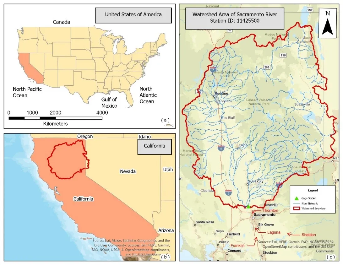
31 October 2024Analyzing Climate Dynamics and Developing Machine Learning Models for Flood Prediction in Sacramento, California
Climate change is leading to rapid environmental changes, including fluctuating precipitation and water levels, which raises the risk of flooding in coastal and riverine locations around the United States. This study focuses on Sacramento, California, a city significantly affected by these changes and recent severe flooding disasters. The ultimate goal is to understand the climate dynamics and create a more robust model to alert Sacramento and other communities to possible flooding and better prepare them for future climatic uncertainty. In this research, four classification machine learning models—Support Vector Machine (SVM), Random Forest (RF), Artificial Neural Network (ANN), and Long Short-Term Memory (LSTM)—are examined for their capacity to predict the occurrence of floods using historical precipitation temperature and soil moisture data. Our results demonstrate that the LSTM model, with an accuracy of 89.99%, may provide better reliable flood predictions, possibly due to its ability to process complicated temporal data. SVM, RF, and ANN showed accuracies of 81.25%, 83.75%, and 85%, respectively. The study explores the correlation between increasing precipitation incidents and severe climate variations, such as the El Niño and La Niña cycles, which could have increased flooding risks. Significant rainfall peaks occurred in 1998 and 2007, indicating that external atmospheric circumstances might have considerably impacted local weather patterns. While LSTM models show potential, there remains room to improve their accuracy and adaptability in extreme flood scenarios. Given these findings, future research could combine multiple environmental data sources and hybrid modeling approaches to enhance predictions.