

SciEPublish

Geospatial Assessment of Water Security in Mining-Affected Watersheds: A Systematic Review of Composite Indices, Methodological Gaps, and the Proposed Mining Water Security Composite Index ICSHM

Review Open Access

Geospatial Assessment of Water Security in Mining-Affected Watersheds: A Systematic Review of Composite Indices, Methodological Gaps, and the Proposed Mining Water Security Composite Index ICSHM

Author Information
1
Graduate Program in Analysis and Modeling of Environmental Systems, Institute of Geosciences, Federal University of Minas Gerais, Belo Horizonte 31270-901, Brazil
2
Servicio Nacional de Aprendizaje SENA, Quibdó-Chocó 27001, Colombia
*
Authors to whom correspondence should be addressed.

Received: 30 June 2026 Revised: 23 September 2026 Accepted: 15 October 2026 Published: 28 October 2026

Creative Commons

© 2026 The authors. This is an open access article under the Creative Commons Attribution 4.0 International License (https://creativecommons.org/licenses/by/4.0/).
Views:285
Downloads:100
J. Watershed Ecol. 2026, 1(3), 10023; DOI: 10.70322/jwe.2026.10023
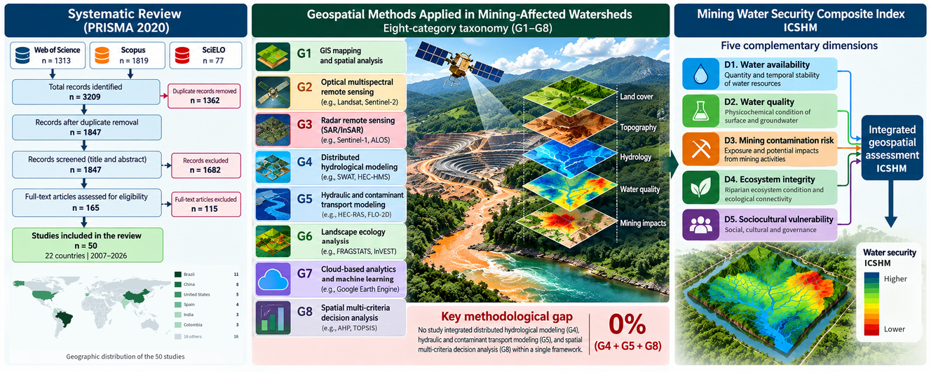
ABSTRACT: Mining activities constitute one of the most significant anthropogenic pressures on freshwater systems worldwide, producing diverse impacts on water availability, water quality, and ecosystem integrity. Despite substantial advances in geospatial technologies, none of the assessment frameworks identified in the reviewed corpus comprehensively integrates these dimensions for mining-affected watersheds. This systematic review aimed to identify, classify, and synthesize water security indices and geospatial assessment frameworks applied to mining-affected watersheds worldwide, develop an original taxonomy describing their methodological structure, and identify the research gaps supporting the development of the Mining Water Security Composite Index ICSHM. Following the Preferred Reporting Items for Systematic Reviews and Meta-Analyses (PRISMA) 2020 (Preferred Reporting Items for Systematic Reviews and Meta-Analyses) guidelines, systematic searches were conducted in the Web of Science, Scopus, and SciELO databases, covering the period from 2007 to 2026 (3209 initial records). Reference management and screening were performed using Zotero 7.0 and Rayyan. Data extraction was based on an original eight-category geospatial taxonomy (G1–G8) covering Geographic Information Systems (GIS) mapping, optical and radar remote sensing, distributed hydrological modeling, hydraulic and contaminant transport modeling, landscape ecology, cloud-based analytics, and spatial multi-criteria decision analysis, while methodological quality was assessed using an adapted Critical Appraisal Skills Programme (CASP)–Joanna Briggs Institute (JBI) framework. From 1847 unique records screened, 50 studies conducted across 22 countries met the inclusion criteria. The review identified two major methodological gaps. First, none of the 17 identified water security indices simultaneously incorporates the five dimensions proposed in this review for the assessment of mining-affected watersheds. Second, none of the reviewed studies integrates distributed hydrological modeling, hydraulic and contaminant transport modeling, and spatial multi-criteria analysis within a single assessment framework (G4 + G5 + G8 = 0%). These findings provide a strong methodological rationale for the proposed ICSHM, which is structured around five complementary dimensions: water availability, water quality, mining contamination risk, ecosystem integrity, and sociocultural vulnerability. The framework integrates geospatial methods represented by categories G1–G8 and is designed to support future validation across mining-affected watersheds with contrasting environmental and mining settings.
Keywords: Water security; Mining-affected watersheds; Geospatial assessment; Composite index; Systematic review; Watershed management; Remote sensing; Hydrological modeling; ICSHM

Graphical Abstract

TOP