Detecting and Mapping Stoebe vulgaris Post Herbicide Control, Using UAV Imagery and Machine Learning

Detecting and Mapping Stoebe vulgaris Post Herbicide Control, Using UAV Imagery and Machine Learning
Debbie Jewitt
1,2,*
 Michelle Keith
3
Erika van Zyl
4
Michelle Keith
3
Erika van Zyl
4
Received: 25 March 2026 Revised: 20 April 2026 Accepted: 28 April 2026 Published: 12 May 2026

© 2026 The authors. This is an open access article under the Creative Commons Attribution 4.0 International License (https://creativecommons.org/licenses/by/4.0/).
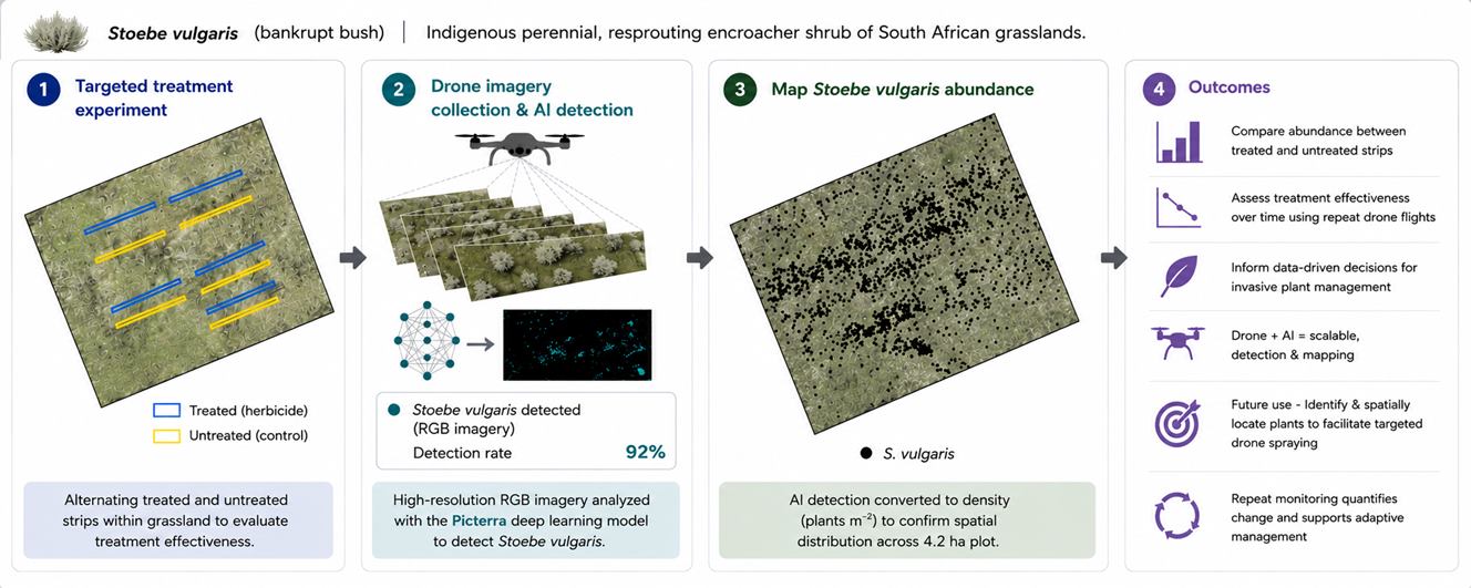
Graphical Abstract
1. Introduction
Invasive alien plant species (IAPs) represent a major global threat to biodiversity, reducing ecological functionality and impacting ecosystem services [1]. In South Africa, woody encroaching species are transforming vast areas of grassland into less productive shrublands, severely reducing grazing capacity and threatening economic livelihoods [2]. Addressing this crisis necessitates precise knowledge of spatial distribution and spread dynamics [3], yet traditional field surveys are often inefficient, costly, and limited in scope, particularly over large or hard-to-access areas. Recent advancements in Unmanned or Uncrewed Aerial Vehicles (UAVs) combined with machine learning (ML) offer promising, high-resolution alternatives for monitoring, bridging the gap between field work and satellite remote sensing [4].
Stoebe vulgaris Levyns (Asteraceae), formerly known as Seriphium plumosum [5], is a common indigenous encroacher of South African grasslands [6,7]. The perennial, resprouting shrub has an erect to spreading growth form, characterized by thin, wiry, open branches and small, greyish leaves. It stands up to 1.5 m in height and can develop a canopy up to 2 m in diameter [8,9]. It has encroached over 11 million ha of rangelands in South Africa [5].
S. vulgaris can outcompete other indigenous plants and palatable grasses and thereby change the composition and structure of grasslands [10]. This leads to decreased grazing capacity, reduced land value, and declines in ecosystem functioning. It is unpalatable to livestock and has no known natural enemies [11]. Encroachment and thickening of S. vulgaris in grasslands have commonly been associated with historically cultivated areas [12], areas with nutrient poor soils [9] and/or poor grazing management practices [13,14] and the situation is exacerbated by ongoing disturbances of fire and grazing [13,15]. Commonly referred to as “bankrupt bush”, this species is named for its propensity to dominate rangelands, rendering farming economically unviable [11,16]. S. vulgaris was formally declared an indigenous bush encroacher species in South Africa in 2019 (Conservation of Agricultural Resources Act of 1983 [17]). Landowners are obligated to control the bankrupt bush to protect rangeland health. More than 30 control and management studies of S. vulgaris in the past 85 years [5] identified that an adaptive and integrated management strategy was required for sustained control [6,7,11,18], with herbicide and mechanical control the most commonly used by farmers [7].
Satellite and airborne sensors are important tools for monitoring invasive species. However, invasive species are often interspersed with other vegetation, making the detection of the targeted species difficult with moderate resolution imagery [19]. UAVs provide high-resolution spatial and temporal data essential for monitoring these species [4,20], effectively bridging the gap between ground-based field surveys and satellite remote sensing [21]. By acquiring both colour (RGB) and multispectral imagery, UAVs offer an affordable, versatile alternative to satellite data [20]. Furthermore, vegetation indices derived from this imagery enhance the ability to assess plant health and facilitate precise species discrimination. This versatility has increasingly allowed precision monitoring of crops [22], specific species [23], restoration efforts [24], and monitoring invasive plants [19].
This study aimed to develop a drone-based, machine-learning approach for mapping and monitoring S. vulgaris. We specifically determined the optimal season and weather conditions, flight orientation parameters, and imagery required to maximize detection accuracy.
2. Materials and Methods
2.1. Study Area
The trial took place at the Dundee Research Station (latitude 28°8′ S and longitude 30°17′ E) in KwaZulu-Natal (KZN) province of South Africa (Figure 1), administered by the KZN Department of Agriculture and Rural Development. The altitude was 1236 m, and the vegetation type was the Income Sandy Grassland [25]. The area receives a mean annual summer rainfall of 748 mm and a mean annual temperature of 16.7 °C [25]. The landscape has flat, extensive areas with shallow sandy soils derived from sandstones and shales of the Madzaringwe Formation, which are poorly drained. It is a tussock-dominated sourveld with mosaics of tree species (e.g., Vachellia sieberiana, V. karroo, V. nilotica and Diospyros lycioides) [25]. Its conservation status is classified as vulnerable [26]. The study site was located on historically cultivated land that has undergone significant encroachment by S. vulgaris (Figure 2a). The study site was located within a camp primarily utilised for winter cattle grazing.
2.2. Trial Description
The study area was burnt with a prescribed fire in October 2017, October 2022 and November 2025. Fire was primarily used to reduce herbaceous biomass as part of the rotational veld management system. Herbicide control studies of S. vulgaris have identified metsulfuron-methyl, triclopyr, and tebuthiuron [9,11,18,27] as effective treatments, with metsulfuron-methyl having the least effect on non-target species [28,29], less residual soil toxicity than tebuthiuton [30,31], whilst effectively reducing plant density and cover. In January 2018, the S. vulgaris regrowth was treated with the selective herbicide, metsulfuron-methyl 500 g WP (Nicanor® 50 WP, ADAMA, Cape Town, South Africa) at the prescribed dosage rate of 50 g active ingredient (a.i.) ha−1. The herbicide was applied by boom sprayer in alternate 25 m strips across the heavily encroached area of the camp, forming alternate treated and untreated strips (Figure 2). No further chemical control measures were implemented on the site after the single herbicide application in 2018.
Twenty 2.4 × 25 m plots were established, with ten randomly selected plots running along the middle of the treated and untreated strips (Figure 1). Each plot was marked by a permanent concrete marker.
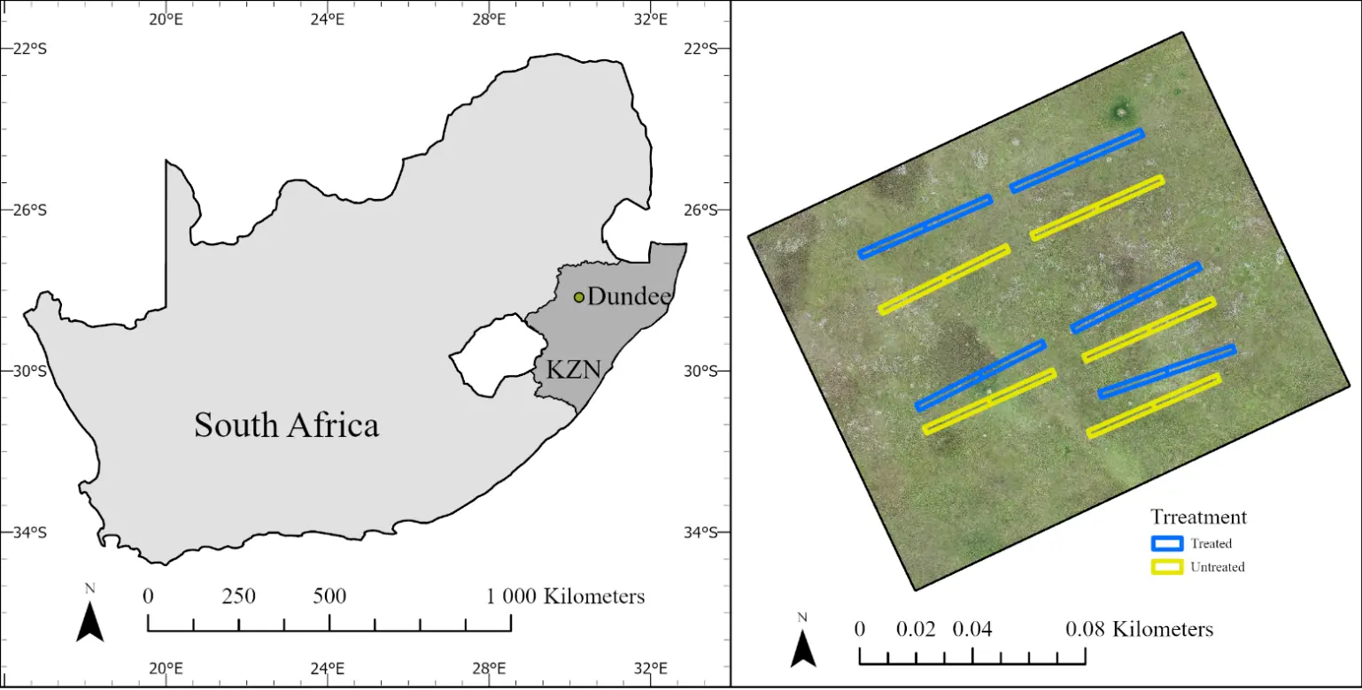
Figure 1. The study area and treatment plots for the study are located at the Dundee Research Station in KwaZulu-Natal, South Africa.
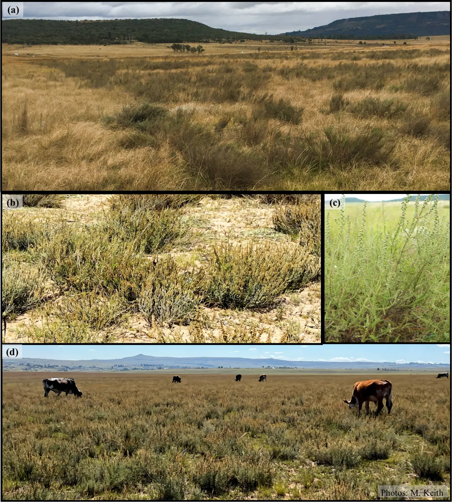
Figure 2. (a) Alternating bands of herbicide treated and untreated Stoebe vulgaris on the study site. (b) Close up of S. vulgaris plants in severely grazed land. (c) The visually cryptic new summer growth of S. vulgaris in the surrounding grasslands. (d) Dense encroachment of S. vulgaris in historically cultivated lands of the Income Sandy Grassland (Photos M.K.).
2.3. Plant Data Collection
S. vulgaris size and population dynamics were assessed along both sides of a 25 m tape measure running down the centre of each plot (25 m × 2.4 m), where every plant rooted or partially rooted on both sides of the tape measure within the plot was measured. Plant size was determined by measuring (a) the height (cm) from the ground and (b) the canopy or crown area (cm2). Canopy area was calculated using the ellipse formula, with two diameter readings measured at right angles to each other at the widest point of the plant canopy [32]. Plant density within each plot was determined by counting every rooted or partially rooted plant, and the density was converted to plants per hectare. Plant size, density, and life stage for all plots were determined in March 2021 and 2023. Plant life stages were classified as seedlings (plants with a crown area of less than 10 × 10 cm) and mature plants (crown area above 10 × 10 cm). Differences in plant density, life stage, and canopy area between treated and untreated plots were evaluated using a two-sample t-test for unequal variances (Welch’s t-test).
In March 2024, the exact GPS position of all S. vulgaris plants within two treated and two untreated plots was recorded. This was done to verify the accuracy of the aerially acquired, modelled data.
2.4. Drone Data
Flights were conducted on 8 February 2024 (late summer), 17 July 2024 (winter), 3 December 2024 (early summer), and 29 November 2025 (post-burn, early summer). Flights were conducted at 40 m AGL with an 80% forward and side overlap, in a standard parallel mapping pattern across two perpendicular orientations (NW-SE and NE-SW). The images were mosaiced using Pix4Dmapper version 4.10 (by Pix4D). The first three flights were conducted using a DJI Phantom 4 Pro (Da-Jiang Innovations, Shenzhen, China) (20MP CMOS sensor) for the colour imagery (Figure 3a) and a DJI Matrice 210 (Da-Jiang Innovations, Shenzhen, China) (20MP CMOS sensor) with a Micasense RedEdge-MX multispectral sensor for the multispectral imagery (Figure 3b). Calibrated reflectance panels were imaged immediately before and after each multispectral flight. The survey area was expanded from the 2.3 ha area of interest to 4.2 ha to mitigate edge effects.
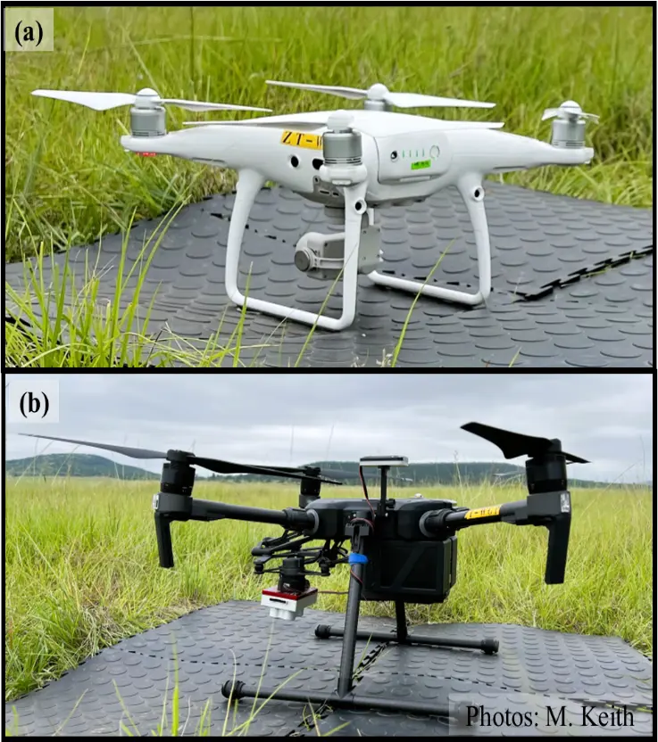
Figure 3. (a) The DJI Phantom 4 Pro (20MP CMOS sensor) was used for the colour imagery. (b) The DJI Matrice 210 (20MP CMOS sensor) with a Micasense RedEdge-MX multispectral sensor was used for multispectral imagery.
Approximately 244 images were captured for each colour imagery flight and approximately 2790 images were collected for each of the multispectral flights. The flight missions were saved and repeated for each new sampling period. This yielded an average resolution of 1.05 cm for the colour imagery and 2.96 cm for the multispectral imagery. The November 2025 flight was conducted using a DJI Mavic 3M (Da-Jiang Innovations, Shenzhen, China) multispectral aircraft (20MP 4/3 CMOS RGB sensor and 5MP G/R/RE/NIR multispectral sensor). Ground control points were used using an Emlid (https://emlid.com, accessed on 8 February 2024) survey system. All images were georeferenced to the February 2024 images in ArcGIS Pro version 3.6.1.
The weather conditions in February were lightly overcast with wind speeds of 1.9 m/s and 30 °C. In July it was a bright sunny day with winds of 5.5 m/s and a maximum temperature of 24 °C. The December weather conditions were bright sun with a few distant clouds, wind of 5.2 m/s, and temperatures of 32 °C. The weather conditions in November were bright sun with a few distant clouds, a strong wind of 6.7 m/s, and a temperature of 28 °C.
Flight speeds were approximately 3.4 m/s for the DJI Matrice 210 and DJI Phantom 4 Pro compared to the faster speed of the DJI Mavic 3M at 11.87 m/s, optimized for the RGB sensor. Flight speeds should have been slower for the DJI Mavic 3M multispectral imagery, ideally 3.5–3.6 m/s. Flight speeds differed among platforms because mission speed is constrained by camera footprint, required image overlap, and minimum photo interval.
2.5. Plant Detection and Modelling
Picterra (https://picterra.ai/, accessed on 15 July 2025) was used to detect and map the S. vulgaris using machine learning algorithms and convolutional neural networks. It is a “no-code” artificial intelligence system to map features. The colour and multispectral imagery from February 2024 were used. The software requires the user to select small training areas where the features of interest are delineated manually by the user, i.e., it requires the human eye to detect and delineate the features of interest. Thereafter, a testing area is used to test how well the model can detect the features. Specific features can be excluded from the model (false positives) to improve performance. The model is run iteratively to refine the model before applying the model at scale.
3. Results and Discussion
3.1. Herbicide Effectiveness
In 2023, S. vulgaris density in untreated plots (M = 6983, SD = 5870) was significantly higher than in herbicide treated plots (M = 1500, SD = 1709), as shown by a Welch’s t-test, t(10.45) = −2.84, p = 0.016. Plant crown area between treated plots (M = 0.31 m2, SD = 0.69 m2) and untreated plots (M = 0.53 m2, SD = 0.43 m2) were not significantly different t(15.06) = −0.88, p = 0.3945, however there were still distinct differences which were detectable both on the ground and from aerial images six-years after the initial treatment application. Seedlings were recorded in both treated (M = 5.5, SD = 7.29) and untreated plots (M = 18.4, SD = 21.49) although these differences were not significant t(11.04) = −1.80, p = 0.100.
Herbicide treatment was highly effective in controlling both the number and size of S. vulgaris, with long-term (six-years) efficacy achieved after the single application of metsulfuron-methyl. The efficacy of this herbicide confirms the findings of short-term studies [11,18]. Reduction in S. vulgaris abundance following initial control allows a shift in follow-up herbicide application from broad-scale boom spraying to more targeted spot-spray approaches, thereby minimising non-target impacts and overall environmental effects [29]. Seedling recruitment was ubiquitous in this study, but higher in untreated plots. Seedlings were difficult to locate in tall grass. It is recommended that areas identified for initial or follow-up herbicide treatment be grazed by livestock to increase the accuracy of determining S. vulgaris density and life-stage, either by eye or from imagery. This study has highlighted the necessity of long-term monitoring of treated areas to identify the optimal treatment frequency for follow-up herbicide applications and corroborates the importance of long-term studies by Marquart et al. [5]. The differences between the plots were detectable on the imagery taken in this study.
3.2. Season of Data Collection
The best season for data collection (Figure 4) was late summer (February). The vegetation was at peak growth and maturity, providing good distinction between species. The winter imagery (July) created extensive shadows and the grey plumage of S. vulgaris did not contrast sufficiently with the brown dry grass surrounding it. In the December (early summer) imagery, the surrounding vegetation was still young and not yet mature, growth being dependent on warmer and wetter conditions. We anticipated that the early summer post-burn (November) imagery would provide high contrast since the grass layer would be short compared to the S. vulgaris shrub. However, the reduced canopy of S. vulgaris from the burn made it difficult to detect the plants. Further, the windy conditions (6.7 m/s) on this day created blurry images, further reducing the ability to visually detect the plants.
From a weather perspective, the best colour orthomosaics were obtained in uniformly light overcast conditions and low wind conditions. The lightly overcast conditions created uniform lighting conditions and removed shadows whilst still allowing fast shutter speeds to reduce motion blur.
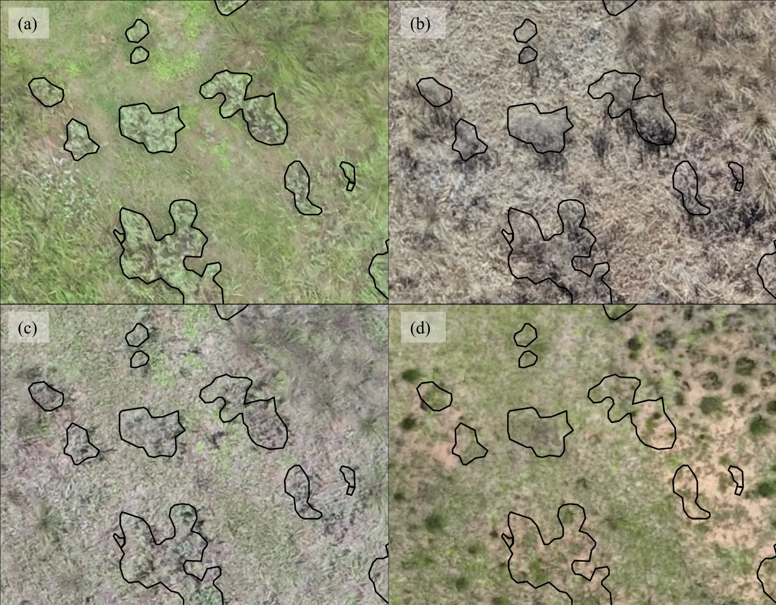
Figure 4. The seasonally acquired imagery with the Stoebe vulgaris plants outlined in black as detected in the February 2024 imagery (a) February 2024 (late summer), (b) July 2024 (winter), (c) December 2024 (early summer), and (d) November 2025 (post-burn early summer).
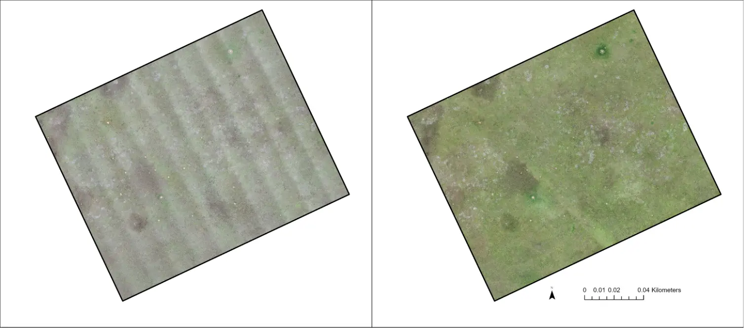
3.3. Flight Orientation
Banding was apparent in the July imagery orientated in the NE-SW direction. However, the worst banding occurred in the December flights with a NW-SE orientation (Figure 5). The sun-sensor geometry can influence image reflectance. Photos taken with the sun behind the camera (backscatter) appear significantly brighter than those where the sensor faces the sun (forward scatter) [33]. This may explain the banding observed in the December imagery flown in the NW-SE orientation during bright sunny conditions. At noon, the winter images have a solar elevation of about 41°, whereas in early December, the solar elevation is about 84° in Dundee (28° S). Hence, July imagery would create longer shadows and have stronger directional lighting, impacting colour balancing. It is recommended that multispectral imagery be obtained by flying perpendicular to the sun [33]. Hence, selecting optimal flight paths and directions is crucial to obtain the best imagery to create orthomosaics and detect plants.
Camera settings were set on auto during the flights, which may have exacerbated the banding effects. Locking the exposure, white balance, and ISO settings may help to remove these effects [34]. The correct settings should be based on the camera’s intensity histogram [33]. Flight speed should also be slower to avoid motion blur, and a fast shutter speed should be used. Flight paths can similarly influence positional accuracy [35]. Reliable and repeatable plant monitoring requires colour accuracy and consistency in the imagery [36]. Repeat image acquisitions across times may result in colour discrepancies [37] requiring effective colour correction methods [36]. Thus, obtaining the best aerial images requires due consideration to flight altitude, image overlap, flight speed, flight direction, the flight pattern, and sensor viewing angle [33,38].
 |
|
|
(a) |
(b) |
Figure 5. (a) The banding effects observed in the December 2024 NW-SE orientation, compared to (b) imagery obtained in February 2024 NW-SE orientation.
3.4. Plant Detection and Modelling
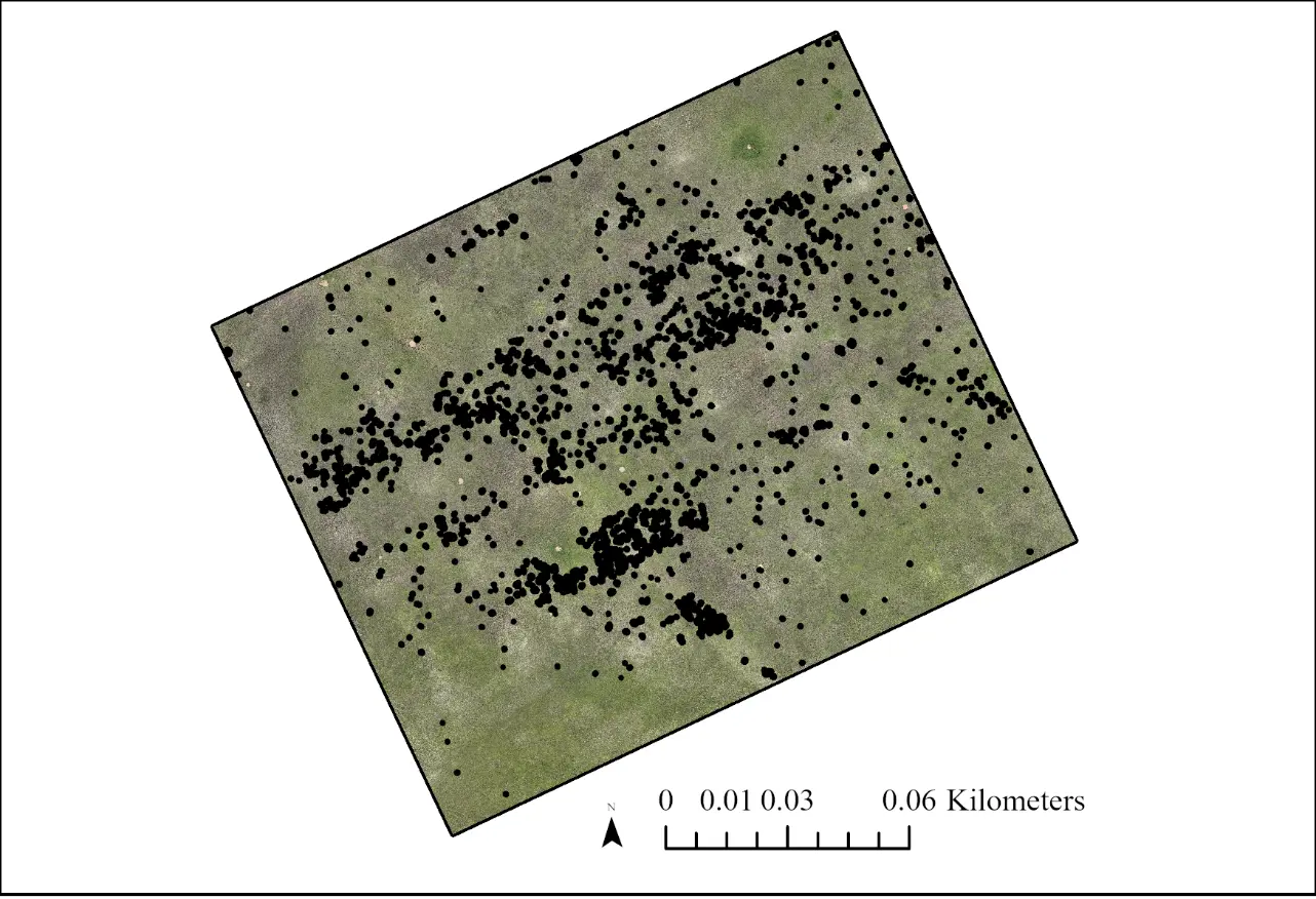
The Picterra model performed well. Detection across the 4.2 ha took 15 min once training was complete. The machine learning detector accuracy for the colour imagery was 92%, with an 8% omission error and 80% identification accuracy. The detector accuracy was 85% for the multispectral imagery. The model detected 1768 S. vulgaris features (Figure 6); these represent canopy cover rather than individual plants, as canopies were often intertwined.
At times, it was visually difficult to distinguish the plant Helichrysum aureonitens from S. vulgaris on the colour imagery. H. aureonitens is a lighter grey colour compared to S. vulgaris. The spectral signature of plants is driven by the biochemical substances in their leaves and stems (e.g., Chlorophyll-a and b, total nitrogen, carotenoids, xanthophyll, leaf moisture content etc.) [39]. Using false colour composites, specifically the red edge, near infrared, and red bands, the spectral signature of the plants became visible and differed in colour (Figure 7). Nkhwanana et al. [40], using Sentinel-2 satellite imagery to detect S. vulgaris, found the Short-Wave Infrared (SWIR), vegetation red edge, and near-infrared bands optimal to discriminate the plant from surrounding vegetation.
The spectral signature of H. aureonitens, using the red edge, near infrared, and red band combination, was blue compared to the light-yellow hue of the S. vulgaris (Figure 7). This made it significantly easier to distinguish these two species and helped to improve the model. Multispectral imagery and vegetation indices have been used successfully in other areas to map features ranging from deserts [41], marine habitat mapping [42], tree risk assessments [43], and precision agriculture [27], amongst others.
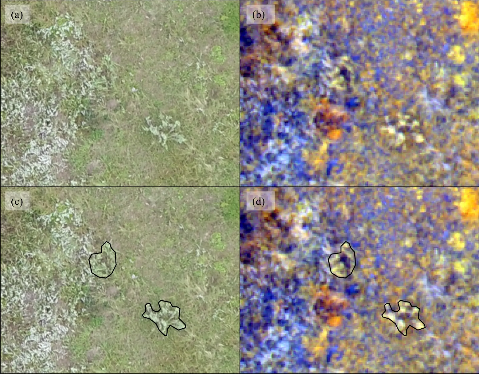
Figure 7. The comparison of colour and multispectral imagery. (a) Colour imagery February 2024 showing Stoebe vulgaris and Helichrysum aureonitens. (b) Multispectral imagery February 2024, (c) The delineation of S. vulgaris plants based on (d) the spectral signature differences between H. aurenitens (blue colour) and S. vulgaris (light yellow).
In comparison to field-based assessments, it was found that seedlings and young plants smaller than 10 cm diameter (similar to detection rates observed by Rominger et al. [44]), were not detected by the model on the aerial imagery (Figure 8). The Minimum Mapping Unit (MMU) dictates the smallest size of a feature that is mapped. It is directly related to pixel resolution and can range between 3 × 3 to 10 × 10 pixels for a feature to be accurately identified. A rule of thumb is to divide the smallest size of the object of interest by four to estimate the pixel resolution required [21]. In our context, seedlings and young plants were obscured in the grass layer, thereby increasing the MMU size, and emphasising the importance of reducing the surrounding grass layer through grazing, where possible. The model detected all the plants occurring in the treated sites. However, some larger plants greater than 10 cm were not detected in the untreated sites. Grazers tend to avoid grazing close to or within the unpalatable S. vulgaris shrubs, especially where density of the shrubs is high. That results in higher grass biomass, hampering the detection and mapping of plants in untreated plots, whereas in treated plots, grazing pressure is higher and the S. vulgaris plants are more visible.
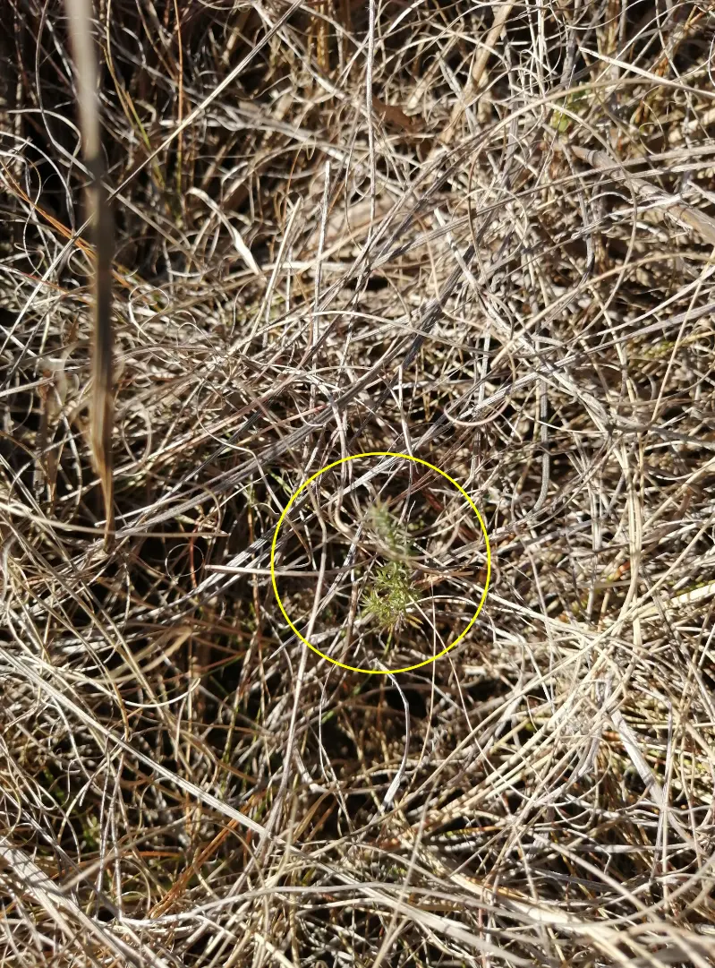
Figure 8. A Stoebe vulgaris seedling in the grass layer that could not be detected in the aerial imagery (Photo D.J.).
Urban et al. [45] used Sentinel-1 Synthetic Aperture Radar and Sentinel-2 imagery to map S. vulgaris at a regional scale. They achieved an 80% classification accuracy. This is a useful technique to detect the level of infestation at large scales. Similarly, Tesfamichael et al. [46] used hyperspectral data with machine learning and multispectral indices to achieve 83–97% accuracy in distinguishing S. vulgaris in grasslands. Dubula et al. [47] had less success discriminating grass from S. vulgaris using spectrometer data.
However, our technique, using high resolution drone imagery, is capable of individual plant detection suited to a farm scale. This opens the way for using advances in drone technology for the aerial application of herbicides in a targeted manner [48,49]. This allows for a reduction in the quantity and volume of herbicide application [48], reducing environmental impacts and reducing the health risks to human operators. Using drones, Sühs et al. [50] found the time taken to detect and control invasive trees was seven times less, and the cost a third, compared with traditional search and control methods. Drones can treat areas that are too steep, rocky, or waterlogged for ground crews or vehicles. Newer methods now allow for the detection of invasive plants in the field by integrating a commercially available drone with a deep learning model [51].
4. Conclusions
The methods presented here provide a valuable tool for detecting and mapping S. vulgaris at high resolution in a heterogeneous grassland landscape. Utilizing Picterra, the automated mapping model achieved 92% accuracy, with multispectral imagery enhancing the discrimination of similarly coloured plants. Identifying and spatially locating S. vulgaris enables targeted aerial spraying, minimizing herbicide costs and reducing environmental impact. Optimal imagery was obtained in later summer under light overcast and mild wind conditions; we recommend careful consideration of flight orientation relative to the solar angle. Furthermore, grazing the field before imaging reduces grass biomass, thereby improving detection. Future work should focus on optimising training algorithms to limit false positives and extending this approach to high-resolution satellite imagery. Finally, applying metsulfuron-methyl (500 g WP) showed a significant long-term reduction in S. vulgaris cover over six years, though continued seedling recruitment necessitates ongoing monitoring to refine treatment timing.
Statement of the Use of Generative AI and AI-Assisted Technologies in the Writing Process
During the preparation of this manuscript, the authors used ChatGPT in order improve the wording and grammar of some sentences, and to assist in creating the graphical abstract. PixelPanda was used to deblur a landscape image and Nero AI was used to deblur and improve the resolution of plant images. After using these tools, the authors reviewed and edited the content as needed and take full responsibility for the content of the published article.
Acknowledgments
The authors wish to thank the staff at the Dundee Research Station for administering the trial and assisting with field data collection. We thank Simphiwe Buthelezi from the Department of Land Reform and Rural Development for assisting with the drone flights in November 2025.
Author Contributions
Conceptualization, D.J., E.v.Z. and M.K.; Methodology, D.J., E.v.Z. and M.K.; Formal Analysis, D.J., E.v.Z. and M.K.; Investigation, D.J., E.v.Z. and M.K.; Data Curation, D.J., E.v.Z. and M.K.; Writing—original draft, D.J. and M.K.; Writing—Review & Editing, D.J., E.v.Z. and M.K.; Project Administration, E.v.Z. and M.K.; Funding Acquisition, E.v.Z. and M.K.
Ethics Statement
Not applicable.
Informed Consent Statement
Not applicable.
Data Availability Statement
Data is available from the authors upon request and successful project registration with both organisations.
Funding
This research was internally funded by the KwaZulu-Natal Department of Agriculture and Rural Development and Ezemvelo KZN Wildlife.
Declaration of Competing Interest
The authors declare that they have no known competing financial interests or personal relationships that could have appeared to influence the work reported in this paper.
References
- IPBES. Summary for Policymakers of the Thematic Assessment Report on Invasive Alien Species and Their Control of the Intergovernmental Science-Policy Platform on Biodiversity and Ecosystem Services; Roy HE, Pauchard A, Stoett P, Renard Truong T, Bacher S, Galil BS, et al., Eds.; IPBES Secretariat: Bonn, Germany, 2023. DOI:10.5281/zenodo.7430692 [Google Scholar]
- Stafford W, Birch C, Etter H, Blanchard R, Mudavanhu S, Angelstam P, et al. The economics of landscape restoration: Benefits of controlling bush encroachment and invasive plant species in South Africa and Namibia. Ecosyst. Serv. 2017, 27, 193–202. DOI:10.1016/j.ecoser.2016.11.021 [Google Scholar]
- Bakacsy L, Tobak Z, van Leeuwen B, Szilassi P, Biró C, Szatmári J. Drone-Based Identification and Monitoring of Two Invasive Alien Plant Species in Open Sand Grasslands by Six RGB Vegetation Indices. Drones 2023, 7, 207. DOI:10.3390/drones7030207 [Google Scholar]
- Zaka MM, Samat A. Advances in Remote Sensing and Machine Learning Methods for Invasive Plants Study: A Comprehensive Review. Remote Sens. 2024, 16, 3781. DOI:10.3390/rs16203781 [Google Scholar]
- Marquart A, Mangani T, Brown LR. The rise of Stoebe vulgaris (formally treated as Seriphium plumosum) in South Africa: A critical review of nearly a century of research. S. Afr. J. Bot. 2026, 190, 447–456. DOI:10.1016/j.sajb.2026.01.013 [Google Scholar]
- Snyman HA. Control measures for the encroacher shrub Seriphium plumosum. S. Afr. J. Plant Soil. 2012, 29, 157–163. DOI:10.1080/02571862.2012.745905 [Google Scholar]
- Avenant P. Report on the National Bankrupt Bush (Seriphium plumosum) Survey (2010–2012); Department of Agriculture, Forestry and Fisheries: Pretoria, South Africa, 2015; pp. 1–48. [Google Scholar]
- Shaik Z, Verboom GA, Oxelman B, Bergh NG. Revision of Seriphium plumosum (Gnaphalieae: Asteraceae) in southern Africa with description of new species in Seriphium. S. Afr. J. Bot. 2024, 165, 367–383. DOI:10.1016/j.sajb.2023.12.046 [Google Scholar]
- Snyman HA. Habitat preferences of the encroacher shrub, Seriphium plumosum. S. Afr. J. Bot. 2012, 81, 34–39. DOI:10.1016/j.sajb.2012.05.001 [Google Scholar]
- Graham SC, Barrett AS, Brown LR. Impact of Seriphium plumosum densification on Mesic Highveld Grassland biodiversity in South Africa. R. Soc. Open Sci. 2020, 7, 192025. DOI:10.1098/rsos.192025 [Google Scholar]
- Marquart A, Slooten E, Jordaan FP, Vermeulen M, Kellner K. The control of the encroaching shrub Seriphium plumosum (L.) Thumb. (Asteraceae) and the response of the grassy layer in a South African semi-arid rangeland. Afr. J. Range Forage Sci. 2023, 40, 316–321. DOI:10.2989/10220119.2022.2086620 [Google Scholar]
- Jordaan D. Bankruptbush (Slangbos)—A silent threat to grasslands? Grassroots Newsl. Grassl. Soc. South. Afr. 2009, 9, 40–42. Available online: https://grassland.org.za/sites/default/files/2023-11/February%202009.pdf (accessed on 27 April 2026).
- Snyman HA. Germination potential of Seriphium plumosum (bankrupt bush, slangbos or vaalbos). Grassroots Newsl. Grassl. Soc. South. Afr. 2009, 9, 43–48. Available online: https://api.semanticscholar.org/CorpusID:131346038 (accessed on 27 April 2026).
- Adepoju K, Adelabu S, Mokubung C. Mapping Seriphium plumosum encroachment and interaction with wildfire and environmental factors in a protected mountainous grassland. Environ. Monit. Assess. 2020, 192, 328. DOI:10.1007/s10661-020-08253-x [Google Scholar]
- Singini EJ, McMillan BM, Newete SW, Witkowski ETF. Ecological drivers of Seriphium plumosum encroachment: Implications for management and conservation. S. Afr. J. Bot. 2025, 176, 21–28. DOI:10.1016/j.sajb.2024.11.001 [Google Scholar]
- Snyman HA. Allelopathic potential, seed ecology, and germination of the encroacher shrub Seriphium plumosum. Afr. J. Range Forage Sci. 2010, 27, 29–37. DOI:10.2989/10220111003718482 [Google Scholar]
- CARA. Conservation of Agricultural Resources Act. Notice No. 883. 1983. Available online: https://www.gov.za/documents/notices/conservation-agricultural-resources-act-declaration-bankrupt-bush-seriphium (accessed on 19 February 2026).
- Nkosi SE, Brown LR, Barrett AS. A baseline study for controlling the indigenous encroacher Stoebe vulgaris in the natural grasslands of Southern Africa. Agric. Ecosyst. Environ. 2018, 265, 209–216. DOI:10.1016/j.agee.2018.06.013 [Google Scholar]
- Singh KK, Surasinghe TD, Frazier AE. Systematic review and best practices for drone remote sensing of invasive plants. Methods Ecol. Evol. 2024, 15, 998–1015. DOI:10.1111/2041-210X.14330 [Google Scholar]
- Baena S, Moat J, Whaley O, Boyd DS. Identifying species from the air: UAVs and the very high resolution challenge for plant conservation. PLoS ONE 2017, 12, e0188714. DOI:10.1371/journal.pone.0188714 [Google Scholar]
- Mathews AJ, Singh KK, Cummings AR, Rogers SR. Fundamental practices for drone remote sensing research across disciplines. Drone Syst. Appl. 2023, 11, 1–22. DOI:10.1139/dsa-2023-0021 [Google Scholar]
- Reddy DVSC, Sahoo RN, Kondraju T, Rejith RG, Ranjan R, Bhandari A, et al. Drone-Based Multispectral Imaging for Precision Monitoring of Crop Growth Variables. Biol. Life Sci. Forum 2025, 41, 10. DOI:10.3390/blsf2025041010 [Google Scholar]
- Rominger KR, Meyer SE. Drones, deep learning, and endangered plants: A method for population-level census using image analysis. Drones 2021, 5, 126. DOI:10.3390/drones5040126 [Google Scholar]
- Robinson JM, Harrison PA, Mavoa S, Breed MF. Existing and emerging uses of drones in restoration ecology. Methods Ecol. Evol. 2022, 13, 1899–1911. DOI:10.1111/2041-210X.13912 [Google Scholar]
- Mucina L, Rutherford MC. The Vegetation of South Africa, Lesotho and Swaziland; Strelitzia 19; South African National Biodiversity Institute: Pretoria, South Africa, 2010; pp. 421–422. [Google Scholar]
- Jewitt D. Vegetation type conservation targets, status and level of protection in KwaZulu-Natal in 2016. Bothalia 2018, 48, a2294. DOI:10.4102/abc.v48i1.2294 [Google Scholar]
- du Toit JCO, Cronje WB, Trollope WSW. Towards a low-input control slangbos (Seriphium plumosum)—Quality and grazing interaction hypothesis. Grootfontein Agric. Dev. Inst. 2013, 13, 21–25. Available online: https://scholar.google.com/citations?view_op=view_citation&hl=en&user=7LEIzVgAAAAJ&cstart=20&pagesize=80&citation_for_view=7LEIzVgAAAAJ:LkGwnXOMwfcC (accessed on 27 April 2026).
- Clark MD, Wonkka CL, Kreuter UP, Rogers WE. Interactive effects of prescribed fire and livestock grazing on Seriphium plumosum in South African sour bushveld. Afr. J. Range Forage Sci. 2020, 37, 278–285. DOI:10.2989/10220119.2020.1751287 [Google Scholar]
- Goodall JM, Witkowski ETF. Selective herbicides extirpate forbs more effectively than alien plants, facilitating dominance of aggressive low grazing value grasses. S. Afr. J. Bot. 2025, 181, 523–536. DOI:10.1016/j.sajb.2025.04.018 [Google Scholar]
- du Toit JCO. Problems with using the herbicide Tebuthiuron for controlling Seriphium plumosum. Grootfontein Agric. Dev. Inst. 2012, 11, 31–40. Available online: https://www.researchgate.net/profile/Justin-Du-Toit/publication/261213758_du_Toit_JCO_2012_Problems_with_using_the_herbicide_tebuthiuron_for_controlling_Seriphium_plumosum_Grootfontein_Agric_1131-40_31/links/0046353396a9b48d69000000/du-Toit-JCO-2012-Problems-with-using-the-herbicide-tebuthiuron-for-controlling-Seriphium-plumosum-Grootfontein-Agric-1131-40-31.pdf (accessed on 9 March 2026).
- du Toit JCO, Sekwadi K. Tebuthiuron residues remain active in soil for at least eight years in a semi-arid grassland, South Africa. Afr. J. Range Forage Sci. 2012, 29, 85–90. DOI:10.2989/10220119.2012.705325 [Google Scholar]
- Pule HT, Tjelele JT, Tedder MJ. The effects of abiotic factors in South African semi-arid grassland communities on Seriphium plumosum L density and canopy size. PLoS ONE 2018, 13, e0202809. DOI:10.1371/journal.pone.0202809 [Google Scholar]
- Maes WH. Practical Guidelines for Performing UAV Mapping Flights with Snapshot Sensors. Remote Sens. 2025, 17, 606. DOI:10.3390/rs17040606 [Google Scholar]
- Leem J, Mehrishal S, Kang I-S, Yoon D-H, Shao Y, Song J-J, et al. Optimizing Camera Settings and Unmanned Aerial Vehicle Flight Methods for Imagery-Based 3D Reconstruction: Applications in Outcrop and Underground Rock Faces. Remote Sens. 2025, 17, 1877. DOI:10.3390/rs17111877 [Google Scholar]
- Ahmed S, El-Shazly A, Abed F, Ahmed W. The Influence of Flight Direction and Camera Orientation on the Quality Products of UAV-Based SfM-Photogrammetry. Appl. Sci. 2022, 12, 10492. DOI:10.3390/app122010492 [Google Scholar]
- Lu X, Xie J, Yan J, Zhou J, Cen H. Precise Image Color Correction Based on Dual Unmanned Aerial Vehicle Cooperative Flight. Plant Phenomics 2025, 7, 100101. DOI:10.1016/j.plaphe.2025.100101 [Google Scholar]
- Tocci F, Figorilli S, Vasta S, Violino S, Pallottino F, Ortenzi L, et al. Advantages in Using Colour Calibration for Orthophoto Reconstruction. Sensors 2022, 22, 6490. DOI:10.3390/s22176490 [Google Scholar]
- Tu YH, Phinn S, Johansen K, Robson A, Wu D. Optimising drone flight planning for measuring horticultural tree crop structure. ISPRS J. Photogramm. Remote Sens. 2020, 160, 83–96. DOI:10.1016/j.isprsjprs.2019.12.006 [Google Scholar]
- Asner GP, Martin RE. Spectral and chemical analysis of tropical forests: Scaling from leaf to canopy levels. Remote Sens. Environ. 2008, 112, 3958–3970. DOI:10.1016/j.rse.2008.07.003 [Google Scholar]
- Nkhwanana H, Adam E, Ramoelo A. Assessing the utility of Sentinel-2 MSI in mapping an encroaching Seriphium plumosum in South African rangeland. Appl. Geomat. 2022, 14, 435–449. DOI:10.1007/s12518-022-00423-5 [Google Scholar]
- Wang N, Guo Y, Wei X, Zhou M, Wang H, Bai Y. UAV-based remote sensing using visible and multispectral indices for the estimation of vegetation cover in an oasis of a desert. Ecol. Indic. 2022, 141, 109155. DOI:10.1016/j.ecolind.2022.109155 [Google Scholar]
- Papakonstantinou A, Stamati C, Topouzelis K. Comparison of True-Color and Multispectral Unmanned Aerial Systems Imagery for Marine Habitat Mapping Using Object-Based Image Analysis. Remote Sens. 2020, 12, 554. DOI:10.3390/rs12030554 [Google Scholar]
- Mazurek K, Zając Ł, Suchocka M, Jelonek T, Juźwiak A, Kubus M. UAV-Based Multispectral Imagery for Area-Wide Sustainable Tree Risk Management. Sustainability. 2025, 17, 8908. DOI:10.3390/su17198908 [Google Scholar]
- Rominger KR, Meyer SE. Application of UAV-based methodology for census of an endangered plant species in a fragile habitat. Remote Sens. 2019, 11, 719. DOI:10.3390/rs11060719 [Google Scholar]
- Urban M, Schellenberg K, Morgenthal T, Dubois C, Hirner A, Gessner U, et al. Using Sentinel-1 and Sentinel-2 Time Series for Slangbos Mapping in the Free State Province, South Africa. Remote Sens. 2021, 13, 3342. DOI:10.3390/rs13173342 [Google Scholar]
- Tesfamichael SG, Newete SW, Adam E. Dubula B. Field spectroradiometer and simulated multispectral bands for discriminating invasive species from morphologically similar cohabitant plants. GIScience Remote Sens. 2018, 55, 417–436. DOI:10.1080/15481603.2017.1396658 [Google Scholar]
- Dubula B, Tefsamichael SG, Rampedi IT. Assessing the potential of remote sensing to discriminate invasive Seriphium plumosum from grass. South Afr. J. Geomat. 2016, 5, 201–213. DOI:10.4314/sajg.v5i2.8 [Google Scholar]
- Nobre FLDL, Santos RF, Herrera JL, Araújo AL, Johann JA, Gurgacz F, et al. Use of drones in herbicide spot spraying: A systematic review. Adv. Weed Sci. 2023, 41, e020230014. DOI:10.51694/AdvWeedSci/2023;41:00028 [Google Scholar]
- Guebsi R, Mami S, Chokmani K. Drones in precision agriculture: A comprehensive review of applications, technologies, and challenges. Drones 2024, 8, 868. DOI:10.3390/drones8110686 [Google Scholar]
- Sühs RB, Ziller SR, Dechoum M. Is the use of drones cost-effective and efficient in detecting invasive alien trees? A case study from a subtropical coastal ecosystem. Biol. Invasions 2024, 26, 357–363. DOI:10.1007/s10530-023-03190-5 [Google Scholar]
- James K, Bradshaw K. Detecting plant species in the field with deep learning and drone technology. Methods Ecol. Evol. 2020, 11, 1509–1519. DOI:10.1111/2041-210X.13473 [Google Scholar]