Found 4 results
Article
06 December 2024Population Dynamics and Stock Assessment of the Spottail Mantis Shrimp Squilla mantis (Linnaeus, 1758) in the North Aegean Sea, Greece
In Greek waters, the spottail mantis shrimp Squilla mantis (Linnaeus, 1758) presents significant ecological and low to moderate economic value. This study investigates the population dynamics and stock assessment of the species in the north Aegean Sea. A total of 856 individuals were collected using commercial bottom trawls between April 2021 and April 2023. Key population parameters such as size distribution, sex ratio, growth, size at maturity and spawning seasonality were assessed. Results indicate a relatively stable population with a slight male dominance and peak spawning activity occurring in late spring to early summer. Growth parameters were estimated using the von Bertalanffy growth model, revealing moderate growth rates and a maximum length slightly higher than previously recorded for this species in other Mediterranean regions. Stock assessment, conducted through yield-per-recruit analysis, suggests that the current exploitation levels are approaching sustainable limits. However, potential overfishing risks necessitate continuous monitoring and the implementation of adaptive management strategies. This study underscores the importance of integrative approaches combining biological and fisheries data to ensure the sustainable management of S. mantis populations in the Aegean Sea.
Review
30 September 2024The Jerusalem Megalithic Rock Calendar Is an Identical Representation to That Found in Lanzarote Island (Canary Islands, Spain)
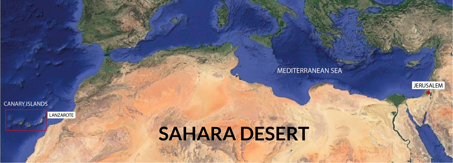
We have recently found that a megalithic basaltic rock lunisolar calendar in Lanzarote, Canary Islands (“Quesera or Cheeseboard” of Zonzamas) has almost a twin monument in Jerusalem (Al Quds in Arab). These two unique monuments are on the West and East sides of the Sahara Desert and support the hypothesis of a common “Green” Saharan culture and a later migration of people towards the Atlantic, Mediterranean, Middle East and other areas when desiccation started after 10,000 years BC, thus spreading culture and genes. Traces of this culture can still be found in Iberian rock inscriptions on the Canary Islands and in the Sahara Desert, particularly at Tim-Missaou in Algeria.This is concordant with Usko-Mediterranean languages (Basque and Berber are related and also with Iberian and Etruscan), genetics and other common anthropological traits. In this paper, we analyse the Al Quds-Jerusalem megalithic monument as representing a solar calendar of Egyptian-type (365 days in 1 year) and show how it could be identical to the Lanzarote megalithic calendar (“Quesera or Cheeseboard” of Zonzamas). Both monuments,each crest/channel, are coincidental in each solar month assignment in both Lanzarote and Jerusalem rock calendars representation. Jerusalem’s megalithic calendar was built at least 900 years BC, when it fell out of use. Therefore, it can be assumed that the Lanzarote megalithic calendar was constructed around a similar time, meaning an undetermined period over 2800 years ago.
Review
15 April 2024Human Mobility in the Central and Eastern Mediterranean during Hellenistic and Roman Times: The Potential and Limitations of Bioarchaeological Research
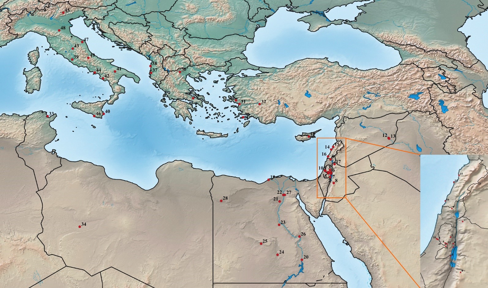
This paper offers a review of bioarchaeological research on human mobility during the Hellenistic and Roman period in the Central and Eastern Mediterranean. This period was marked by significant connectivity amidst the establishment of major political entities. The paper begins with an overview of bioarchaeological methods used to study past mobility, including biodistance, isotopic and ancient DNA analyses. It then examines published studies that have utilized these methods to explore mobility during the Hellenistic and Roman periods. The paper concludes by critically assessing the current research limitations and proposing directions for future studies. These suggestions emphasize the importance of conducting additional research to investigate human mobility in neglected areas, as well as at different temporal and spatial scales. Integrating mobility data with other sources of evidence, such as historical accounts, paleoenvironmental data and osteobiographic information is another important future direction of research. Finally, relevant research should be more theoretically informed and its contemporary implications should be effectively communicated within and beyond the academic community. An enhancement of our understanding of the nature and impact of mobility is crucial in today’s society, where misconceptions linking immigration to the decline of the Roman Empire can perpetuate biases against contemporary mobility.
Article
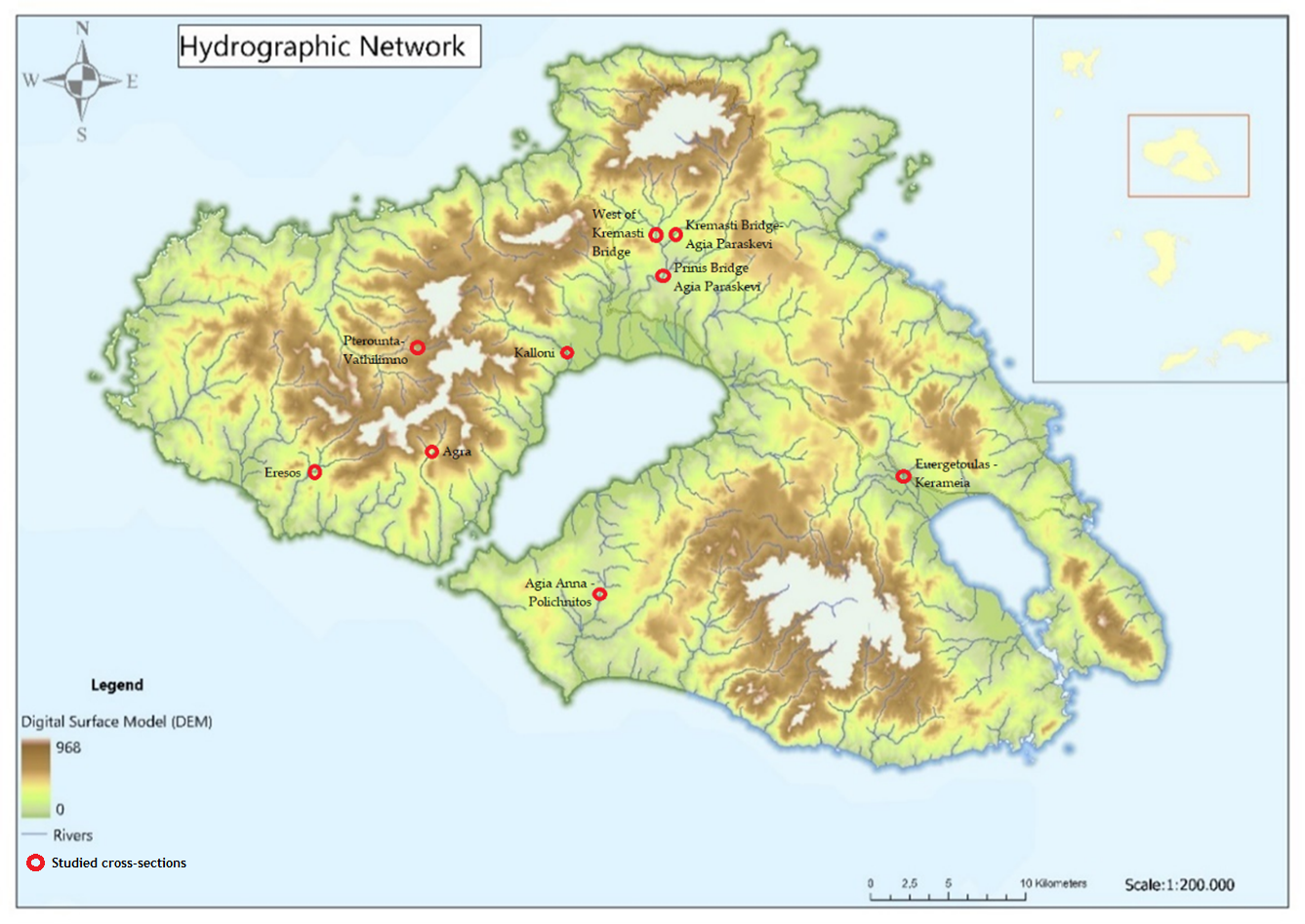
27 November 2023Enhancing the Monitoring Protocols of Intermittent Flow Rivers with UAV-Based Optical Methods to Estimate the River Flow and Evaluate Their Environmental Status
Temporary streams are a key component of the hydrological cycle in arid and semi-arid regions, but their flow is highly variable and difficult to measure. In this paper, we present a novel approach that could be used to assess the flow of temporary streams this allowing to characterize their environmental status. Specifically, we apply the Image Velocimetry (IV) method to estimate surface velocity in temporary streams using Unmanned Aerial Vehicles (UAVs) equipped with optical sensors (IV-UAV method). The IV-UAV method enables the easy, safe and quick estimation of the velocity on the water’s surface. This method was applied in different temporary streams in Lesvos Island, Greece. The results obtained indicate that the IV-UAV can be implemented at low discharges, temporary streams and small streams. Specifically, the water depth ranged from 0.02 m to 0.28 m, while the channel width ranged from 0.6 m to 4.0 m. The estimated surface velocity ranged from 0.0 to 5.5 m/s; thus, the maximum water discharge was 0.60 m3/s for the largest monitored stream of the island. However, there were many occasions that measurements were unable due to various reasons such as dense vegetation or archaeological sites. Despite of this, the proposed methodology could be incorporated in optical protocols which are used to assess the environmental status of temporary streams of Mediterranean conditions. Finally, this would become a valuable tool for understanding the dynamics of these ecosystems and monitoring changes over time.