Spatial Analysis in Bioclimatic Architecture: Meteora, a UNESCO World Heritage Site, Greece

Spatial Analysis in Bioclimatic Architecture: Meteora, a UNESCO World Heritage Site, Greece
Received: 26 January 2026 Revised: 24 February 2026 Accepted: 01 April 2026 Published: 13 April 2026

© 2026 The authors. This is an open access article under the Creative Commons Attribution 4.0 International License (https://creativecommons.org/licenses/by/4.0/).
1. Introduction
The unique symbolic elements of settlements provide insights into their formative journeys. When examining the developmental processes of settlements, it is evident that environmental and structural components, along with historical events and transformations, have played a significant role in shaping their distinctive identities. Geography shaped by natural conditions and climatic characteristics—referred to as bioclimatic—is highly influential in the formation of settlements [1]. Climate has been a decisive factor in the selection of settlement locations, land use, spatial formation, and transportation. Moreover, it contributes to a sense of place and identity [2]. Landforms, rocks, plains, soil, and socio-environmental units serve as fundamental data in shaping settlement areas. In addition to influencing settlement planning, wildlife presence, and architectural patterns, climate also helps establish distinguishing features that contribute to the identity of a place. Furthermore, the climate serves as a key element of attraction for tourism activities. It plays a role in determining the absolute or relative appeal of a destination. Beyond being a valuable natural resource, climate is also a primary component in assessing the potential for tourism development [3].
The Meteora area is a tourist destination in Northern Greece, known for its massive rock formations, stacked deltas, and monasteries perched atop the peaks [4]. These dark sandstone formations are located above the town of Kalambaka, near the Pindos and Chassia mountain ranges. They are generally understood to have formed during the Paleogene period, approximately 65 million years ago. Their present-day appearance is thought to result from long-term processes such as weathering, erosion, and seismic activity [5].
Meteora is also the name of the sacred monasteries that began to be constructed atop these steep cliffs in the 14th century. In the mid-14th century, Monk Neilos gathered solitary monks living in the surrounding caves near the Skete of Doupiani, thus initiating organized monastic life in Meteora [6]. Today, Meteora Monasteries constitute Greece’s second most significant monastic complex after Mount Athos. Historically comprising 30 monasteries, only six remain active today. Most of these six have been restored and are preserved, welcoming visitors in their current form in Meteora.
Bioclimatic architecture focuses on adapting built environments to local climatic conditions to improve environmental comfort and sustainability. Elements such as solar orientation, wind exposure, topography, and natural shading play a decisive role in shaping settlement patterns and architectural forms [7,8]. The landscapes, shaped in accordance with natural landscapes, form a spatial organization under the influence of climate. In this context, Meteora’s monastic structures represent a unique settlement area where rock formations, cave settlements, and elevated rock complexes interact with the local microclimate. The orientation of the structures, the use of rock cavities to provide thermal mass, and the placement of monasteries on elevated rock columns show a spatial formation that reflects the bioclimatic effects of sunlight exposure, wind direction, and seasonal climate conditions [9].
2. Literature Review
Although the concept of bioclimatic architecture has been more closely examined recently, it has existed since the beginning of history. Ancient Greek philosophers and architects, such as Socrates and Vitruvius, emphasized the importance of designing structures in harmony with their environment. These practices are clearly seen in the spatial orientation of buildings, the use of local materials, and the placement of architectural textures in accordance with climatic conditions.
Today, the concept of bioclimatic architecture is understood as an approach that emphasizes designs that deliver climate-sensitive solutions, ensuring human comfort, energy efficiency, and environmental sustainability. Examples from across Europe show that settlements in Mediterranean climates are suitable, while those in colder Alpine regions are adapted to those climates. These spatial adaptations contribute to sustainability while also enhancing cultural and urban identity.
Geomorphological features and spatial formations create unique, realistic, sustainable spaces. Stratification in the horizontal plane and the presence of hard, durable layers create niche uses within caves or natural formations.
Bioclimatic architecture refers to the suitability of building forms to local climatic conditions through planning approaches such as orientation, use of thermal mass, natural ventilation, and solar control [10,11]. This approach is observed to create traditional and local settlements in which environmental constraints shape the spatial organization. In this context, negative, semi-negative, and positive spaces, which define the original space, can be interpreted as architectural plans for the microclimatic conditions created by rock formations. Accordingly, the sample spatial areas examine how the settlement orientation, environmental integration, and climate-sensitive planning approaches placed within the existing landscape are reflected.
When examining spatial formations in bioclimatic architecture, human settlement dates back to the 10th century, when people began to settle in natural formation cavities. In this context, three basic types of spatial use are identified in the literature [12,13,14]:
-
-
Negative Space: Dark cells integrated into the natural formation function as thermally embedded micro-environments. The high thermal mass of conglomerate sandstone balances daily temperature variations, ensuring indoor heat balance in both summer heat and winter cold. Predominantly south and southeast-facing cavities increase winter solar energy gain, while recessed geometric areas reduce wind effects and excessive heating in summer. This natural space typology provides passive climatic adaptation through enclosure and mass.
-
-
Semi-Negative/Semi-Positive Space: Partially embedded space cells combine the thermal effect provided by the natural formation with man-made added facades that regulate daylight and ventilation. Orientations towards the east and southeast limit heat gain from the west while optimizing heating with passive solar energy. The hybrid combination creates a transitional bioclimatic planning approach between fully enclosed and fully open spaces by providing controlled airflow and low humidity.
-
-
Positive Space: Built on top of a natural formation area, climate-sensitive approaches are used in spatial designs that influence height, orientation, and a dense mass. Southeast-facing entrances maximize the use of sunlight while minimizing north-facing openings, which reduces heat loss and wind impact, creating indoor thermal balance. The inner courtyard arrangement and protruding spatial formations support the creation of passive solar energy and natural ventilation. This spatial typology demonstrates the optimal use of natural environmental conditions in architectural design decisions.
These dynamic areas, shaped by natural formations, are considered to have unique cultural values. These bioclimatic areas, formed by their unique geography, are designated as UNESCO World Heritage sites. Bioclimatic areas, where extraordinary geological formations and historical architectural heritage coexist in harmony, are architectural areas that require protection. Regions in this typology generally fall within broader ecological frameworks such as the Natura 2000 Network and require integrated conservation plans. In these contexts, these areas need to be protected according to certain Universal, National, Regional, Local criteria among the pressures of their natural formation, the preservation of cultural integrity, environmental sustainability, and regional tourism management [15,16]:
-
-
Authenticity: Original materials, functions, and spatial arrangements are largely preserved.
-
-
Integrity: The entirety of natural and built elements, visual, functional, and identity consistency are preserved.
-
-
Tourism Management: With increasing visitor numbers, measures such as visitor restrictions, guided routes, and infrastructure limitations have been implemented to reduce pressure (Table 1).
Table 1. UNESCO World Heritage Value.
|
Superior Universal Values (SUV) |
|||
|---|---|---|---|
|
Protection Management |
Authenticity |
Integrity |
Criteria |
|
Factors and threats State of conservation Management |
Form and style Historical materials Use and function |
Physical integrity Visual integrity Structural integrity |
Universal National Regional Local |
With the defined conservation criteria, it is envisioned that the sustainability of the area and its preservation as a legacy for future generations will be ensured. This study, within the framework of Spatial Analysis in Bioclimatic Architecture, focuses on Meteora in Greece, a UNESCO World Heritage site, as the sample area.
3. Materials and Methods
This study uses spatial orientation and climate data methods to examine the relationship between spaces shaped by bioclimatic factors in Meteora. Climate data for the area (temperature, precipitation, prevailing winds) were obtained from official meteorological sources through research. ArcGIS Pro software, was used to visually map the locations of monasteries, the orientation of rock faces, and elevation and slope to better understand the spatial context. Entrance orientations were measured in azimuth degrees and classified into 45° directional sectors. Aspect analysis enabled evaluation of solar exposure and wind protection relative to settlement positioning. Field measurements and on-site observation, documentation of façade exposure and shading conditions, assessment of rock integration depth (thermal mass potential), and observation of ventilation openings and wind sheltering. Entrance orientations were grouped (N–NW) and percentage distributions calculated to identify directional clustering. Rock aspect data were cross-analyzed with monastery and hermit cave locations. Descriptive statistics were used to evaluate concentration toward climatically advantageous sectors (E–SE), (Table 2).
Table 2. Research Design Framework.
|
Phase |
Data (Primary/Secondary) |
Tools |
Key Parameters |
Outcome |
|---|---|---|---|---|
|
Climatic Analysis |
Secondary (meteorological data) |
Solar & wind mapping |
Temperature, radiation, prevailing winds |
Bioclimatic context defined |
|
GIS Mapping |
Primary + Secondary |
ArcGIS |
Entrance orientation, aspect, elevation |
Spatial–climate relationship identified |
|
Field Survey |
Primary (on-site) |
Compass, photography |
Shading, ventilation, and rock integration |
Climate-responsive features documented |
|
Orientation Analysis |
Primary |
Descriptive statistics |
Directional frequency (N–NW sectors) |
Directional clustering quantified |
|
Correlation |
Integrated dataset |
Comparative analysis |
Solar exposure & wind protection vs. placement |
Bioclimatic adaptation verified |
4. Case Study Context: Meteora
4.1. Environmental Values/Natural Environment
Meteora is located in a geographically significant area near the town of Kalampaka, in the Thessaly region of Greece, surrounded by the Antichasia Mountains. The monasteries in this region are uniquely situated atop towering rock pillars that rise approximately 400–500 m above the ground. These geological formations are of exceptional importance due to their distinctive natural characteristics (Figure 1) [1].
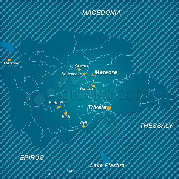
Figure 1. Location of Meteora [17], (https://www.greeka.com/pictures/maps/meteora-map.gif, accessed on 9 March 2026).
When viewed from afar, Meteora presents the appearance of a vast forest of towering rock pillars, comprising nearly a thousand individual rock formations that captivate and astonish visitors. The settlements in these natural geological formations constitute an extraordinary settlement structure; the average height of the gigantic rock masses, which have a significant impact on the area, reaches 313 m. Some of the largest rock formations are approximately 300 m wide and reach approximately 200 m in height, creating an impressive and majestic spatial formation of magnificent rock landscapes formed from layers over the years [15,18].
The Meteora settlement area was shaped by geological formations. The shaping process of the region started from prehistory, it is known that the region was first covered by the sea, and then the process of uplift, with the gradual accumulation of sedimentary layers, extends to the Paleogene period. Over millions of years, natural processes such as wetlands, tectonic movements, and weathering gradually shaped these sediments, creating the striking vertical rock columns of great height today [15,19].
Later tectonic processes played a significant role in shaping the massive rock formations we see today. The movement and collision of the Eurasian and African tectonic plates led to the formation of the Mesohellenic Depression, a large geological basin extending from present-day Albania to the Kalampaka settlement area. Approximately 20 million years ago, this basin was known to be filled with molasse sediments carried by rivers and formed from lake and swamp environments. These sediments are formed from the combination of various materials, including gravel, sandstone, marl, gneiss, and other geological elements [20].
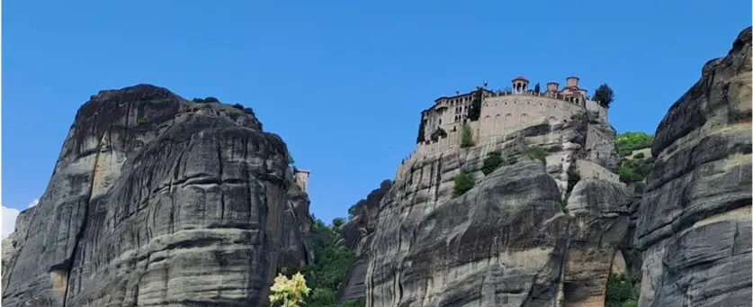
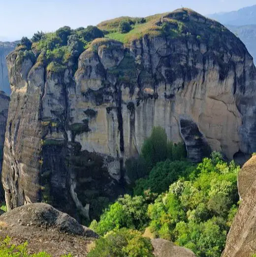
Approximately five million years ago, the depression of the basin floor and the uplift of the surrounding strata led to the formation of the present-day Thessaly Plain and the massive rock formations that define Meteora. This complex geological evolutionary process shaped the region’s unique natural landscape and also formed the basis of its cultural and spiritual significance. Meteora’s rock formations were created over time from successive sedimentary layers, with spatial formations also influenced by climate. These layers appear as distinct, parallel layers on the rock surfaces, easily visible even from a distance (Figure 2).
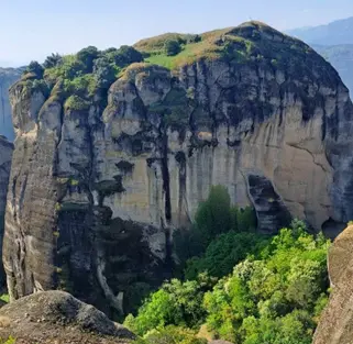
While climatic conditions may not have played a major role in the formation of rock masses, they have contributed to the formation of caves, a fundamental element of present-day spatial formations. In this case, they indirectly contribute to spatial formation. These cave systems are still developing gradually (Figure 3). This process, which began approximately 10,000 to 20,000 years ago, continues very slowly, constantly influencing the geological and environmental character of the region.
Meteora’s geological formations consist primarily of Paleogene conglomerate sandstones. Over millions of years, the combined effects of river systems and tectonic forces gradually formed these rocks into the vertical columns seen today, averaging approximately 313 m in height. However, this geological formation and bioclimatic change also created spatial formations. The spaces provided by the massive rocks formed a settlement plan and transformed the area into a destination.
When viewed and evaluated within this context, beyond geomorphological features, climatic conditions play a significant role in shaping Meteora’s spatial organization. It shows that spatial orientations are largely concentrated on rock faces facing south and southeast; this allows the higher-lying spaces to benefit from better sunlight during the winter months. Similarly, the orientation of entrances also appears to be inclined towards design decisions that benefit from favorable sunlight. From this perspective, it seems that the prevailing northerly winds also influenced the settlement plan decisions, as most of the main monasteries are located behind rock formations that act as natural wind barriers. Furthermore, area analyses indicate that their high locations improve air circulation during the summer months while also helping to limit moisture accumulation.
When the Meteora destination, which is on the UNESCO World Heritage list, is analyzed, the region [21]:
-
-
Hot, dry summers (average 26–32 °C in July)
-
-
Cold winters (average 5–9 °C in January)
-
-
Prevailing northern and northwestern winds
-
-
Strong seasonal solar variation
-
-
Moderate annual precipitation (approx. 650–700 mm)
The towering rock pillars generate localized microclimatic variations. Analyses reveal that south-facing rock surfaces benefit from longer periods of sunlight, which raise their temperatures and create more comfortable indoor conditions during winter months. Conversely, north-facing surfaces tend to remain cooler and retain more moisture. The dense structure of sandstone, a conglomerate building material, helps to balance day-night temperature variations, while airflow through rock cavities supports the creation of comfortable environments. Furthermore, airflow accelerates as it passes through the narrow gaps between rock formations, demonstrating the influence of climatic conditions on the settlement pattern. The spaces created by these climatic conditions play a significant role in explaining both the spatial arrangement and architectural form of Meteora’s monastic landscape.
The high thermal mass of the conglomerate sandstone, the natural building material from which the structures are formed, provides passive thermal regulation, ensuring comfortable indoor air conditions within the cells integrated with the rocks. Differences in altitude and orientation create local microclimates, contributing to the hierarchical distribution of the hermitage caves and organized monastic complexes.
4.2. Environmental Values/Built Environment
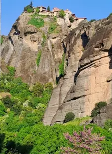
When considering the formations in relation to the built environment, it is thought that the oldest spatial formations developed in the region in the 10th and 11th centuries. The cells provided by Meteora’s unique natural character were discovered by monks, and as they began to live in the natural cavities and small spaces formed within the rock formations, spatial formations began to take shape. For their daily worship, they constructed primitive chapels, known as proseucharia, or prayer chapels. By the following century, the number of monks began to increase. The first organized attempt at communal monastic life occurred in the 12th century with the establishment of the Doupiani or Stagoi plateau, located just outside the present-day village of Kastraki. At its center stood a small church dedicated to the Virgin Mary, which served as the kyriakon (the Lord’s house) or the protestantikon (main church) of the first monastic state of Meteora. Every Sunday, all the hermits of Meteora would gather at this small church for communal worship, coming from their individual hermitages and cave dwellings. In the early 20th century, a movement emerged to revitalize the Meteora monasteries. For the first time, staircases and bridges carved into the rocks were constructed to facilitate easier access to the monasteries. This marked the end of the centuries-old tradition of ascending the rock pillars using nets or rope ladders [10] (Figure 4).
The microclimate in Meteora, including low humidity and consistent wind patterns, has played a role in preserving these geological forms.
 |
 |
 |
| (a) | (b) | (c) |
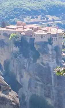
Figure 4. (a) The built environment of Meteora-Holy of Saint Nicholas Anapafsas; (b) The built environment of Meteora-Holy Monastery of Great Meteoron; (c) The built environment of Meteora-Holy Monastery of Saint Stephen, (author archive).
4.3. Spatial Organization within Rock Grooves: Integration with Natural Formations
The integration of built forms with Meteora’s naturally formed rock grooves reveals three distinct typologies of spatial settlement:
-
Construction within the rock groove—negative space
-
Lateral construction along the rock groove—semi-negative and positive space
-
Construction atop the rock groove—creation of positive space
4.3.1. Habitation within the Rock Groove—Negative Space
From a bioclimatic perspective, the use of rock cavities corresponds to passive environmental control strategies identified in bioclimatic architecture theory [22].
In the case of structures built into the interior of rock grooves, the resulting space is negative space. Negative space is a spatial condition in which a seemingly solid structure is designed to serve the formation of space, both internally and externally. Although positive spaces appear to form a boundary surrounding the environment, they are actually hollow, and the cells form a hidden and alternative layer of space [22].
Within Meteora’s rock formations, this spatial arrangement reflects a hermitic monastic tradition centered on solitude and ascetic practice. The use of negative space appears in the form of small, isolated hermit cells scattered across a broad area, strengthening both the spiritual meaning and the architectural character of the landscape (Figure 5) [19].

Hermitage Negative Cells
Hermitage’lerdeki hücreler genellikle ahşap veya taştan yapılmış sade yapılar olup, bazen ahşap balkonlarla desteklenir. Bu mütevazı mimari formlar, kayalık oyuklara yerleştirilmiş olup, yalnız ibadete uygun minimalist ve ascetik bir yaşam tarzını yansıtır.
4.3.2. Lateral Structures in Rock Crevices—Semi-Underground and Positive Space
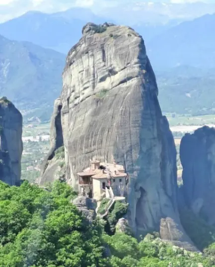
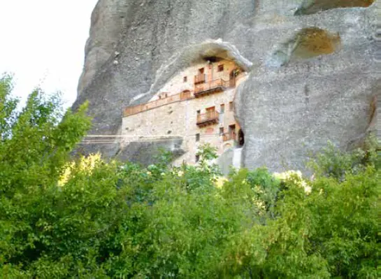
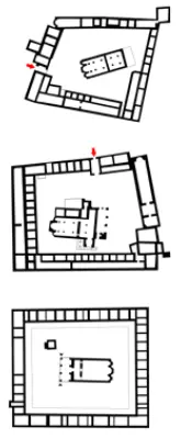
In the Meteora area, there are also monastic cells that can be described as semi-underground spaces, built laterally into the rock face and surrounded by a constructed facade. These lateral structure cells generally have a more complex spatial plan and consist of multiple spatial sections accessible from the inside, usually three stories high. Important examples of this typological spatial organization include the Monastery of St. Nicholas Badovas and the Monastery of the Meeting of Jesus, both integrated into rock formations and demonstrating a combination of enclosed, centrally opening spatial planning (Figure 6).
4.3.3. Building on Top of the Rock Groove—Positive Space
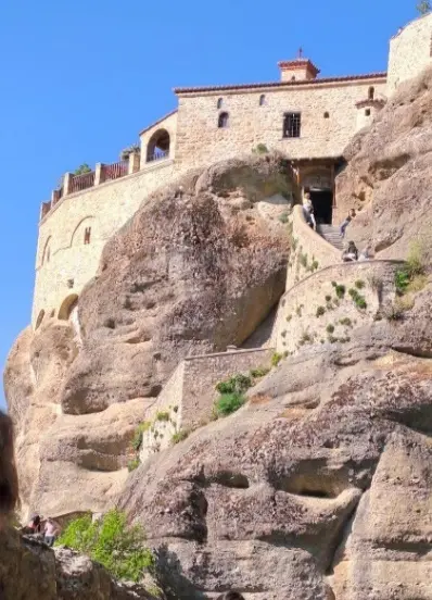
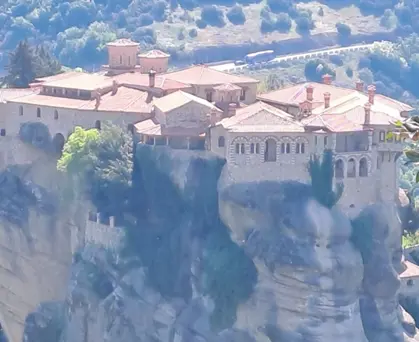
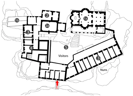
These are monumental structures built on top of rock pillars, known as organized monasteries. Six of them are still active today: The Great Meteoron, Varlaam, St. Stephen, Roussanou, Holy Trinity, and St. Nikolaos Anapafsas Monasteries (Figure 7). Such spatial positioning aligns with the principles of solar orientation and natural ventilation emphasized in bioclimatic architectural design [11].
5. Results and Findings
While Meteora is widely recognized for its cultural and geological significance, its spatial organization also reflects adaptations to local environmental and climatic conditions. Therefore, a spatial bioclimatic analysis helps to reveal how topography, solar exposure, and wind patterns influenced the distribution and architectural form of the monastic structures.
The bioclimatic analysis of the Meteora monastery structures reveals the influence of environmental natural formations. Most of the monastery entrances face southeast or east, creating a layout that maximizes morning sunlight while protecting against the prevailing cold north winds. Many of the caves where intercourse took place are located on south-facing rock faces and feature spaces that benefit from winter heat retention. Inside the caves, the surrounding conglomerate building material ensures a regular temperature balance within the thermal mass of the rock. Natural rock formations surround the monasteries, which are positioned on the peaks of the rock masses, protecting them from the prevailing north winds, and wooden balconies on the south facades capture the winter sun, providing passive solar heating.
Looking at Meteora’s planning, it’s clear that its spatial arrangement is neither random nor purely symbolic, but rather a planned organization reflecting regional climatic adaptation. The architectural expression is defined by stone masonry, wooden balconies, and tiled roofs, utilizing both local materials and adaptable design approaches. Over time, particularly in the 20th century, alterations such as staircases and bridges have increased accessibility, making Meteora a more tourist-friendly destination while preserving its sacred character.
Shaped by these climatic formations, Meteora was included in the UNESCO World Heritage List in 1988 and in the European Natura 2000 Network of sites in 1995. Within this framework, in 1995, the Meteora region was declared a sacred, inviolable, and unalterable area. According to UNESCO criteria, the site is considered to have exceptional universal value.
Meteora, both a strong religious monastic site and a tourist destination, is a significant area in terms of conservation, authenticity, integrity, and cultural value. While the monastic structures built on the rock formations are physically well-preserved, visitor numbers must be managed to prevent excessive tourism pressure. In terms of authenticity, Meteora represents a globally unique architectural heritage recognized by the UNESCO World Heritage List; the form, style, natural materials, function, spiritual value, and preservation of the structures contribute to the site’s unique identity. By maintaining its physical, visual, and structural integrity, the site creates a timeless experience for visitors, and the sustainability of this integrity and its preservation for future generations is vital. Meteora stands out as a remarkable example of cultural heritage encompassing both tangible and intangible dimensions, meeting a wide range of architectural and cultural criteria at universal, national, regional, and local levels.
6. Discussions
The plan organization of the monastic structures in Meteora demonstrates contextual influences linked to local environmental and climatic conditions. However, this plan organization emphasizes a definitively determining relationship; upon examination of the site, it becomes clear that the spatial formations are shaped by bioclimatic influences or forms of environmental adaptation.
The spatial characteristics of the monastic structures in Meteora are shaped by environmental and climatic formations. The integration of the spaces into the rock mass, daily temperature balance, and thermal heat mass create comfort in the interiors. In terms of height, wind resistance, and ventilation, structures at higher levels are exposed to stronger airflow, which, while improving natural ventilation, also increases vulnerability to heat loss. The orientation of the structures affects seasonal solar energy gain. Entrances facing southeast or south receive more sunlight in winter, resulting in warmer interiors, while preventing overheating in summer. When these features are considered together, it suggests that environmental sensitivity was taken into account in the design of the structures, although there is no definitive proof that it was directly used.
When the orientation of the monastery entrances is examined, it is thought that the planning, with most facing southeast or east, aimed to maximize sunlight while minimizing the structures’ exposure to cold northern winds. Although this planning organization does not appear random, there is no clear tendency toward a conscious climatic design. However, the consistency of this arrangement suggests that climatic factors may have contributed to the planning. Similarly, hermit caves are often located on south-facing rock faces. South-facing orientations tend to facilitate the planning of more thermally comfortable spaces by providing higher solar energy gain. The lack of a directly described literature suggests this is seen as a potential environmental adaptation rather than a conscious design planning.
The difference between negative, semi-negative, and positive spatial typologies lies in their planning according to environmental interaction. Areas deeply embedded in the rock (negative areas) reduce daily temperature variations indoors while simultaneously balancing the interior temperature. Elevated structures on rock peaks (positive areas) are more exposed to wind and climate change, but also increase heat loss by creating natural ventilation. Semi-negative areas, on the other hand, create an interface transition space by striking a balance between exposure and protection.
These observations highlight the simultaneous consideration of multiple environmental factors. Spaces integrated with the rocks affect thermal comfort, altitude influences wind exposure and ventilation, and orientation creates seasonal solar energy gain. All these observed factors suggest that the spatial planning of the monastery may reflect a contextually sensitive form of environmental adaptation.
The spatial planning research in this study relies on spatial observation and morphological interpretation, without direct information from literature research sources regarding analysis, thermal performance, airflow, or site selection. Therefore, the findings are interpreted not as a conscious bioclimatic design spatial reflection, but as approaches consistent with environmental adaptation.
Future research could strengthen these investigations by incorporating quantitative environmental data such as temperature monitoring, solar radiation analysis, and wind modeling to clarify the design decision-making processes behind monastic settlements. Statistical analysis of orientation distributions is also expected to support these findings by explaining non-random spatial patterns based on the data.
As a result, although the spatial formations in Meteora are not consciously transferred to the design based on climatic factors, a consistent spatial planning pattern overlaps with the environmental conditions. This demonstrates context-sensitive, environmental adaptation that determines the relationship between spatial form and climate.
7. Conclusions
Meteora represents the intersection reflecting the importance of bioclimatic influences, geomorphological evolution, and cultural heritage. The impressive landscape of gigantic columnar rocks, shaped by tectonic and layer formation processes over millions of years, shapes not only the physical environment but also the architectural texture of human settlement plans. The establishment of monastic communities on natural rock formations reflects the dialogue between natural original formations and human creativity.
Originally formed as a remote spiritual retreat, Meteora has evolved into a globally recognized world heritage and tourism destination site. This transformation demonstrates how natural and human functions can coexist and adapt within a sustainable framework. It also shows that bioclimatic principles (solar orientation, wind bias, sensitivity to thermal mass) have long been integrated not only in contemporary designs but also into vernacular and spiritual architecture. In this context, bioclimatic sensitivity is used as a planning tool to support both sustainable planning and cultural continuity and innovative tourism development.
Conserving Meteora’s tangible and intangible assets requires proactive management that ensures its current environmental and socio-economic sustainability. Maintaining the site’s integrity and resilience necessitates integrated climate adaptation planning, visitor impact assessment, and collaboration and accountability among numerous stakeholders, including local communities, religious authorities, cultural heritage experts, and policy actors.
Therefore, Meteora should be viewed not only in terms of its cultural, religious, and spatial significance but also as an example of local architecture, representing an early model of climate-adapted architecture. Bioclimatic analysis should be integrated into heritage management planning, and sustainable tourism planning can be improved in the following ways:
-
-
Controlling visitor flow according to microclimatic vulnerability
-
-
Designing climate-sensitive infrastructure
-
-
Supporting long-term conservation under changing climatic conditions
Understanding Meteora through a bioclimatic spatial lens contributes to both heritage sustainability and contemporary destination management discourse.
Examining Meteora from a bioclimatic and geomorphological perspective allows for a comprehensive understanding of its formation as both a natural and a cultural system. This approach is particularly important in the context of the golden age of climate change and increasing tourism pressures, as these factors increasingly affect cultural heritage sites. Effective management plans should balance ecological protection with the preservation of cultural identity, offering adaptable vision plans that respect the sacred character of the site while maintaining accessibility and meaningful experiences for future visitors.
In conclusion, Meteora represents a model settlement for sustainable cultural heritage, where bioclimatic awareness and cultural significance are closely intertwined. In this sense, the continuous preservation of the area and its recognition as a living landscape will depend on our attitudes and approaches to integrating environmental responsibility with cultural values in a world where global problems and the effects of climate change are increasingly prevalent.
Statement of the Use of Generative AI and AI-Assisted Technologies in the Writing Process
During the preparation of this manuscript, the author(s) used ChatGPT in order to help determine the correct spelling of some words. After using this tool/service, the author(s) reviewed and edited the content as needed and take(s) full responsibility for the content of the published article.
Ethics Statement
Not applicable.
Informed Consent Statement
Not applicable.
Data Availability Statement
Not applicable.
Funding
This research received no external funding.
Declaration of Competing Interest
The author declares that she has no known competing financial interests or personal relationships that could have appeared to influence the work reported in this paper.
References
-
Ateş O, Kiper T, Uzun O. The Relationship between Tourism Planning and Bioclimatic Comfort in Rural Areas. Turk. J. Agric.—Food Sci. Technol. 2023, 11, 883–896. DOI:10.24925/turjaf.v11i4.883-896.5063 [Google Scholar]
-
Bell S. Landscape: Pattern, Perception and Process; Taylor & Francis: Abingdon, UK, 1999. [Google Scholar]
-
Kakvan R, Alijani B, Saliqeh M. Evaluation of tourism climate conditions at three stations of Noshahr, Ramsar and Rasht using the physiological equivalent temperature and average predicted polling index. Revista Eletrônica Em Gestão Educação E Tecnologia Ambiental 2022, 24, e22. DOI:10.5902/2236117040273 [Google Scholar]
-
Ferrier J, Chanier F, Reynaud J-Y, Pavlopoulos A, Ditbanjong P, Migiros G, et al. Tectonic control of the Meteora conglomeratic formations (Mesohellenic basin, Greece). Bulletin de la Société Géologique de France 2011, 182, 437–450. DOI:10.2113/gssgfbull.182.5.437 [Google Scholar]
-
Poulios I. The Past in the Present: A Living Heritage Approach—Meteora; Ubiquity Press: London, UK, 2014. [Google Scholar]
-
Daniilia S, Minopoulou E, Konstantinos SA, Tsakalof A, Bairachtari K. From Byzantine to Post-Byzantine Art: The painting technique of St Stephen’s wall paintings at Meteora, Greece. J. Archaeol. Sci. 2008, 35, 2474–2485. DOI:10.1016/j.jas.2008.03.017 [Google Scholar]
-
Olgyay V. Design with Climate: Bioclimatic Approach to Architectural Regionalism; Princeton University Press: Princeton, NJ, USA, 1963. [Google Scholar]
-
Givoni B. Climate Considerations in Building and Urban Design; John Wiley & Sons: Hoboken, NJ, USA, 1998. [Google Scholar]
-
Santamouris M, Asimakopoulos D. Energy and Climate in the Urban Built Environment; James & James Science Publishers: London, UK, 2001. DOI:10.4324/9781315073774 [Google Scholar]
-
Gaitani N, Mihalakakou G, Santamouris M. On the use of bioclimatic architecture principles in shaping urban climate and energy demand. Energy Build. 2015, 86, 125–134. DOI:10.1016/j.buildenv.2005.08.018 [Google Scholar]
-
Aste N, Buzzetti M, Del Pero C, Leonforte F, Manfren M. Energy retrofit of commercial buildings: A case study. Energy Effic. 2012, 111, 629–638. DOI: 10.1007/s12053-012-9168-4 [Google Scholar]
-
Ching FDK. Architecture: Form, Space, and Order, 4th ed.; John Wiley & Sons: Hoboken, NJ, USA, 2014. [Google Scholar]
-
Norberg-Schulz C. Genius Loci: Towards a Phenomenology of Architecture; Rizzoli: New York, NY, USA, 1980. [Google Scholar]
-
Rasmussen SE. Experiencing Architecture; MIT Press: Cambridge, MA, USA, 1964. [Google Scholar]
-
UNESCO. Meteora. UNESCO World Heritage Centre. 1988. Available online: https://whc.unesco.org/en/list/455 (accessed on 9 March 2026).
-
European Commission. Interpretation Manual of European Union Habitats—EUR28; European Commission: Brussels, Belgium, 2013. [Google Scholar]
-
Meteora Map. 2024. Available online: https://www.greeka.com/pictures/maps/meteora-map.gif (accessed on 9 March 2026).
-
Papathanassiou M. The Monasteries of Meteora: History and Architecture; Melissa Publishing House: Athens, Greece, 2001. [Google Scholar]
-
Aubouin J, Blanchet R, Cadet JP, Celet P, Charvet J, Chorowicz J, et al. Rampnoux Essai sur la géologie des Dinarides. Bulletin de la Société géologique de France 1970, 7, 1060–1095. DOI:10.2113/gssgfbull.S7-XII.6.1060 [Google Scholar]
-
Mantaka E. Holy Meteora; Ephesus Publishing: Athens, Greece, 2023. ISBN 978-618-5750-02-2 [Google Scholar]
-
Weather and Climate in Meteora, Greece. 2024. Available online: https://weather-and-climate.com (accessed on 9 March 2026).
-
Chitra K, Rahini P, Sundaresan T, Manikandan P, Waleed M. Exploring Positive Space and Negative Space in Architecture, JETIR May 2023, Volume 10, Issue 5. ISSN-2349-5162. Available online: https://www.jetir.org/papers/JETIR2305A34.pdf (accessed on 9 March 2026).