Spatial and Temporal Changes in Shifting Cultivation in Mizoram: Drivers and Implications

Spatial and Temporal Changes in Shifting Cultivation in Mizoram: Drivers and Implications

Received: 13 March 2026 Revised: 10 April 2026 Accepted: 21 April 2026 Published: 30 April 2026

© 2026 The authors. This is an open access article under the Creative Commons Attribution 4.0 International License (https://creativecommons.org/licenses/by/4.0/).
1. Introduction
Shifting cultivation is a centuries-old farming practice primarily practiced in tropical and subtropical regions of the world. The major areas where shifting cultivation is practiced include Central African countries, South American countries, and Southeast Asia. In India, it is practiced in the Northeast and in a small part of the Uttarakhand Himalayas. Globally, about 280 million ha of land is under shifting cultivation, of which 110 million ha is concentrated in Southeast Asia [1]. Northeast India alone accounts for about 0.76 million ha of land under shifting cultivation, representing nearly 80% of India’s total Jhum-cultivated area (0.94 million ha) [2]. In the past, shifting cultivation served as the primary livelihood option and a substantial source of income in these regions, which are generally mountainous, remote, and economically underdeveloped. The practice is traditionally rainfed and characterized by low crop production and productivity. Areas where shifting cultivation is undertaken are typically forested, dominated by bamboo, and located on sloping terrain [3].
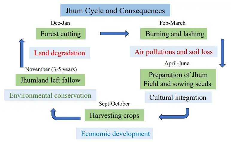
Shifting cultivation is also known globally as swidden, slash-and-burn, or shifting cultivation. In Northeast India, it is referred to as Jhum or Jhuming agriculture, and farmers who practice it are called Jhumias [4]. The practice follows a cyclic pattern (Figure 1). Forests are cut, burnt, and cleared—generally in February and March in Mizoram. Land preparation takes place in March and April, followed by sowing in May and June. Crops are harvested in September and October, after which the land is left fallow, completing the cycle [5]. The Jhumias then move to new forest areas and repeat the cycle. Traditionally, the Jhum cycle lasted 20–25 years, but in recent decades it has been reduced to a maximum of 3–5 years [6]. In Mizoram, Jhum lands are communally owned and allocated to Jhumias for cultivation, typically for a maximum of two years [7]. These lands are mostly situated on sloping terrain dominated by bamboo forests.
Jhum cultivation holds deep cultural and social significance in Mizoram. It is not only a livelihood option but also a way of life. Although it is a labour-intensive practice with relatively low output, Jhumias in Mizoram continue to value and enjoy it. Their culture, fairs, and festivals are closely associated with Jhum practices. Festivals are celebrated both at the time of sowing seeds and during harvest. Chapchar Kut, one of the most popular festivals of Mizoram, is closely associated with the sowing of seeds in Jhum lands. During the crop season, Jhumias build small bamboo huts on their Jhum plots, where they live temporarily and store harvested produce. Jhum lands are generally located in remote areas, often some distance away from their permanent homes.
Shifting cultivation has been on the decline. In Africa and South America, around 20% of the total area under shifting cultivation has decreased [8]. In Southeast Asia, the area has declined by approximately 8 million hectares, with a significant portion converted into permanent agriculture, particularly in Vietnam [9]. In India, the Northeast states of Mizoram, Manipur, Meghalaya, and Nagaland have witnessed a sharp reduction in land under shifting cultivation [10]. Findings from the present study reveal that in Mizoram, the area under Jhum cultivation has decreased by about 85.1% between 2009 and 2024, with only minimal variation across districts.
Several factors contribute to the decline in shifting cultivation, including climate variability and change [11]. The arable land in Mizoram is only 5%, of which more than 50% is under shifting cultivation. This limited arable land is not sufficient to produce enough crops to adequately feed the population. The increasing population further accelerates pressure on the available land, leading to a significant decrease in output from shifting cultivation. The reduction in the Jhum cycle from 20–25 years to 2–3 years has resulted in decreased crop production [6]. Furthermore, Mizoram has been affected by high climate variability and change, particularly decreased rainfall and increased temperatures, which have negatively affected crop production and productivity under shifting cultivation.
Market facilities are also inadequate. Mizoram produces large quantities of fruits such as oranges, bananas, papayas, and pineapples; however, farmers often do not even cover the basic costs of production. With the increase in educational institutions, many youths are attaining higher education. Due to the availability of more lucrative employment opportunities in both government and private sectors, young people are shifting away from traditional agricultural practices toward service-sector jobs. All these factors are contributing to a significant decline in the area under shifting cultivation [12,13].
The decline in shifting cultivation has far-reaching consequences. The abandoned land resulting from shifting cultivation becomes so degraded that neither further shifting cultivation nor natural forest regeneration occurs. Mizoram is a small and economically underdeveloped state. The decline in agricultural area, production, and productivity has already led to food insecurity.
In the southern districts, such as Saiha, the infant mortality rate is very high due to malnutrition. The erosion of cultural traditions is another consequence of declining shifting cultivation. Many festivals in Mizoram are associated with shifting cultivation, particularly those related to seed sowing and crop harvesting. With the decline of shifting cultivation, these festivals are gradually diminishing.
Although shifting cultivation has been widely studied, this research makes a new contribution by examining the spatial and temporal dynamics of shifting cultivation specifically in Mizoram, Northeast India. This study raises several key questions: What is the current status of the area under shifting cultivation? What factors are contributing to its decline? And how can agriculture in Mizoram be made more sustainable? Based on these research questions, the study examines the spatial and temporal changes in shifting cultivation. It investigates the major factors driving the decline in the area under shifting cultivation and assesses the consequences of this decline on the livelihoods of rural people. Finally, it evaluates the role of the State Government in promoting sustainable agricultural practices and suggests key pathways for transitioning toward sustainable farming systems that can ensure improved livelihoods for rural Jhumias.
2. Review of Literature
Some important literature on shifting cultivation in Northeast India in general, and Mizoram in particular, was reviewed to understand the academic work carried out by researchers on this practice. A study was conducted on the growth and progress of shifting cultivation in Northeast India [14]. In their study, they discussed the contemporary situation of shifting cultivation and its influence on the income and economy of farmers engaged in its practice.
A study reviewing management options and research priorities for shifting cultivation in the steeply sloped regions of Mizoram, Northeast India, was conducted by [15]. The study proposed several sustainable management policies and practices for shifting cultivation. Sati [16] empirically examined shifting cultivation in Mizoram by conducting case studies in 16 villages across eight districts. The study observed that the area and production under shifting cultivation have significantly declined in recent years, although it remains a primary occupation and a major livelihood option. Furthermore, shifting cultivation holds rich cultural significance and continues to be a way of life for the people of Mizoram.
In recent years, people’s perceptions of shifting cultivation have been changing, partly due to declining crop production and productivity and the effects of modernization. A study conducted by [17] observed similar trends. A comparative study on oil palm plantations and shifting cultivation was carried out in the context of the new land-use policy implemented by the State Government [18]. The study revealed that although oil palm plantations have significant economic benefits, marginal farmers still prefer shifting cultivation.
Zodinpuii et al. [19] examined shifting cultivation from different perspectives. They analyzed the diversity of soil macroarthropods in areas under shifting cultivation and also studied the forest ecosystem of Mizoram, as this practice is largely carried out in forested areas and affects forest biodiversity. Sati [4] assessed the economic and ecological implications of shifting cultivation in Mizoram. He further illustrated that the economic significance of shifting cultivation is minimal, particularly under conditions of increasing population and climate change. On the other hand, environmental degradation associated with this practice is high.
Chaudhury and Sarkar [20] conducted a study on comparative analysis of shifting cultivation in Northeast India and further assessed its state-wise status and changing patterns. Wapongnungsang et al. [21] examined soil fertility and rice productivity under shifting cultivation and also studied the impact of fallow length and soil amendments in Mizoram. Sharma et al. [22] investigated various aspects of shifting cultivation, focusing on vegetation dynamics and soil nutrients in fallow lands, particularly in the montane subtropical forests of Mizoram.
Although this study also deals with the practices of shifting cultivation in Mizoram, the methodology adopted is primarily based on data collected from satellite imagery and the use of a geographical information system (GIS) for mapping. The study further employed field observations to validate the satellite data.
3. Study Area
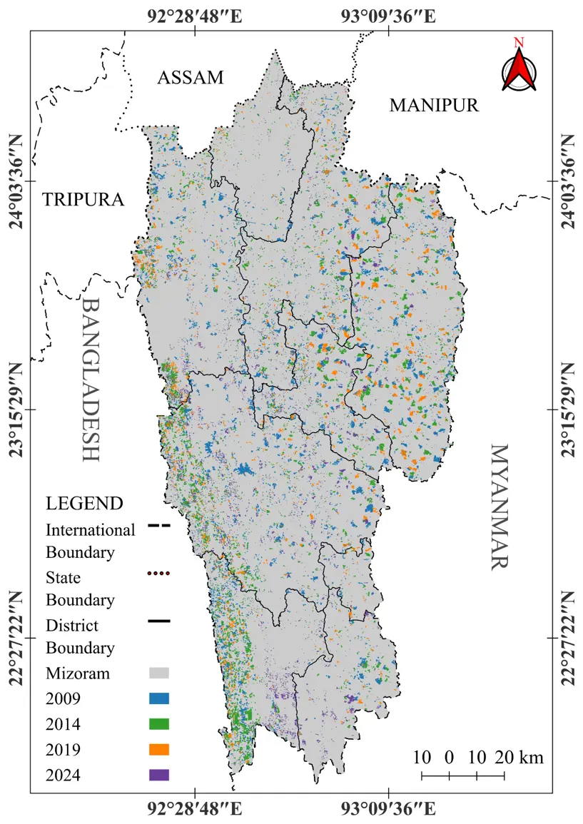
Mizoram is a small state in the Republic of India, located in the extreme south of Northeast India. It shares a long international boundary with Myanmar to the east and south, and with Bangladesh to the west. Within India, it is bordered by Tripura to the northwest, and Assam and Manipur to the north (Figure 2). The state is drained by several perennial rivers, forming three major river basins. The Tlwang River and its tributaries flow northward and join the Barak River, a tributary of the Brahmaputra, in Assam. The Kaladan (Chhimtuipui) River and its tributaries flow south and southeast, while the rivers in western Mizoram flow westward to join the Meghna River. Mizoram is predominantly hilly, with about 97% of its total geographical area (21,081 km2) covered by rugged, precipitous terrain. The remaining 3% consists of valley fills and floodplains [23]. The highest peak in Mizoram is Phawngpui (2157 m above sea level), located in the Blue Mountain range of Lawngtlai district, on the border with Myanmar [24]. The state receives heavy rainfall during the monsoon season, with an annual average of about 2400 mm. Atmospheric humidity remains relatively high, exceeding 80% during the monsoon. The climate is generally pleasant, with an annual average temperature of around 22.5 °C. Forests cover nearly 86% of Mizoram’s geographical area, of which more than 50% consists of bamboo forests. These forests are often cleared for burning and lashing in the practice of jhum (shifting) cultivation. Arable land is scarce, with the net sown area comprising only about 4% of the total. Shifting cultivation dominates the agricultural system, and crops are almost entirely rainfed [25]. The steep and rugged slopes hinder irrigation, as rainwater runs off quickly without much infiltration into the ground. Apart from rainfall, other water sources are limited. Consequently, only one crop is generally harvested per year, and the overall output from shifting cultivation remains quite low.
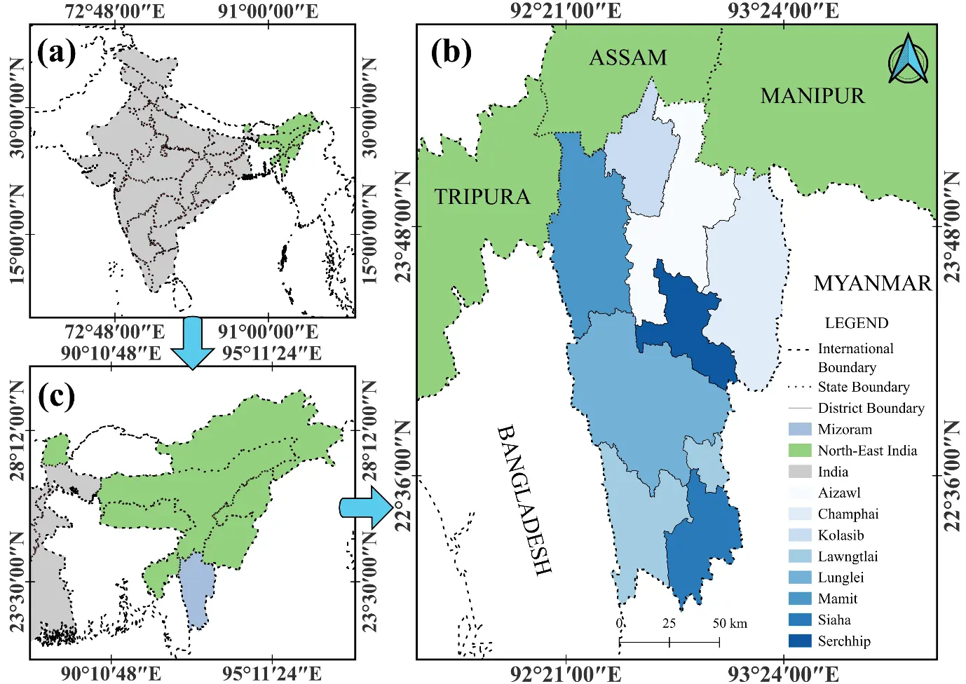
Figure 2. Location map (a) location of Northeat India in India (c) location of Mizoram in Northeast India (b) Location of Mizoram.
4. Methodology
4.1. Data Collection
This study is based on data collected through Remote Sensing (RS) and the application of Geographic Information System (GIS) techniques to quantify the spatial and temporal changes in shifting cultivation in Mizoram from 2009 to 2024. These tools are highly relevant for studying large, rugged, and inaccessible landscapes where traditional field-based surveys are challenging. The primary data source comprised freely available Landsat satellite imageries downloaded from the USGS Earth Explorer. Data analysis was carried out using QGIS, an open-source GIS software (Qgis 3.30). Post-classification correction and validation were conducted using historical images from Google Earth Pro. Specifically, Landsat 5 imagery was used for 2009, Landsat 8 for 2014 and 2019, and Landsat 9 for 2024. Surface reflectance images from the near-infrared and shortwave infrared bands were processed to analyze the extent of shifting cultivation in Mizoram. Shifting cultivation in the state is traditionally practiced by marginal farmers, who burn the jhum land mainly during February and March. Since burnt areas could be distinctly detected, they were classified as jhum land. Direct detection of jhum areas was not feasible due to their spectral similarity to grasslands and bamboo forests. Therefore, satellite images captured between 1st February and 31st March were used, as this period corresponds to the burning season.
Normalized Burn Ratio (NBR) is calculated on both the pre-burn and post-burn satellite images using the formula.
|
```latex\mathrm{N}\mathrm{B}\mathrm{R}=\mathrm{ }\frac{\left(\mathrm{N}\mathrm{I}\mathrm{R}-\mathrm{S}\mathrm{W}\mathrm{I}\mathrm{R}\right)}{\left(\mathrm{N}\mathrm{I}\mathrm{R}+\mathrm{S}\mathrm{W}\mathrm{I}\mathrm{R}\right)}``` |
where, NIR means Near Infrared images and SWIR means short-wave infrared. Then, the following formula is applied.
|
```latex\mathrm{d}\mathrm{N}\mathrm{B}\mathrm{R}=\mathrm{P}\mathrm{r}\mathrm{e}\mathrm{b}\mathrm{u}\mathrm{r}\mathrm{n}\mathrm{ }\,\mathrm{N}\mathrm{B}\mathrm{R}-\mathrm{P}\mathrm{o}\mathrm{s}\mathrm{t}\mathrm{b}\mathrm{u}\mathrm{r}\mathrm{n}\mathrm{ }\,\mathrm{N}\mathrm{B}\mathrm{R}``` |
where, dNBR is the Difference or Delta Normalize Burn ratio. The total area of shifting cultivation was calculated based on the spatial resolution of satellite images. Landsat satellite images are 30-m resolution so,
|
```latex\mathrm{A}\mathrm{r}\mathrm{e}\mathrm{a}\mathrm{ }\,\mathrm{p}\mathrm{e}\mathrm{r}\mathrm{ }\,\mathrm{p}\mathrm{i}\mathrm{x}\mathrm{e}\mathrm{l}=30×30=900\mathrm{ }\,{\mathrm{m}}^{2}``` |
Then, the area is calculated in square meter
|
```latex\mathrm{A}\mathrm{r}\mathrm{e}\mathrm{a}=\mathrm{P}\mathrm{i}\mathrm{x}\mathrm{e}\mathrm{l}\mathrm{ }\,\mathrm{c}\mathrm{o}\mathrm{u}\mathrm{n}\mathrm{t}×900``` |
The calculated square meter is converted into square kilometer
|
```latex\mathrm{Area~(km^2)}=\frac{\mathrm{Area~(m^2)}}{1,000,000}``` |
Data were validated through field visits.
4.2. Field Visit and Interview
The authors conducted field visits to Kolasib, Champhai, Lunglei, and Saiha districts in October 2025. These districts have observed a large decrease in the area under shifting cultivation; therefore, they were selected. A participatory observation approach was employed to understand the major drivers of the decline in shifting cultivation and its consequences.
Furthermore, the authors interviewed a total of 50 heads of households from five villages in these districts. The selection was based on the amount of arable land under shifting cultivation that each respondent holds. These respondents are generally marginal farmers, locally known as Jhumias; however, they hold more land under shifting cultivation in comparison to other marginal farmers in the villages. Their average age was 40 years, and all are literate. The authors interviewed the respondents by raising questions on the area, production, and productivity of shifting cultivation, changes in shifting cultivation, and the drivers and consequences of declining shifting cultivation.
4.3. Data Analysis
The gathered data were analysed using statistical tools. Satellite data were collected for four time periods—2009, 2014, 2019, and 2024—and the data from 2009 and 2024 were analyzed to observe changes. Frequency analysis was employed to identify these changes. Furthermore, district-wise changes were also examined during the two periods. We further analyzed the relationship between the satellite data and the identified drivers to determine the principal drivers of change. Pie diagrams and bar diagrams were also prepared to present data across different timescales.
In addition, an exponential rate was used to record the growth/decline rate. The formula used was: Rate = (End/Start)1/(n − 1) (n = number of years in the period). The percentage of the data were found out and changes were noticed after analyzing them. The burn area concentration zones were classified into three categories: very dense, moderately dense, and sparse. Accordingly, the districts were also grouped into three categories. Burned areas under shifting cultivation for the years 2009, 2014, 2019, and 2024 were illustrated using four maps of Mizoram. A composite map was subsequently prepared to assess changes in shifting cultivation areas.
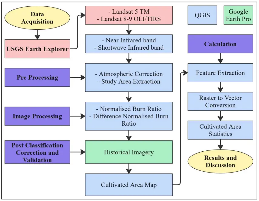
We developed a detailed flowchart of the methodology (Figure 3). It shows data acquisition from USGS, processing methods, calculations, and results and discussion.
5. Results
5.1. District-Wise Area Under Shifting Cultivation in Mizoram
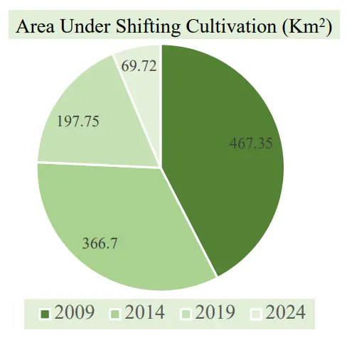
District-wise area under shifting cultivation in Mizoram was analyzed for four different years—2009, 2014, 2019, and 2024. In 2009, the largest area under shifting cultivation was recorded in Lunglei district, followed by Champhai district (Table 1). Aizawl, Lawngtlai, and Mamit districts each had more than 60 km2 under shifting cultivation, while Kolasib and Siaha had very small areas. Serchhip district also had a considerable extent. The total area under shifting cultivation in the state was 467.35 km2.
In 2014 and 2019, a substantial decrease was observed across almost all districts. Lunglei district continued to have the highest area under shifting cultivation, followed by Champhai and Lawngtlai, whereas Kolasib and Siaha recorded the lowest. The total areas under shifting cultivation during these years were 366.70 km2 and 197.75 km2, respectively. By 2024, the area had further declined drastically to just 69.72 km2. Lunglei and Lawngtlai districts still recorded the largest extents (21.56 km2 and 10.89 km2, respectively), while all other districts had less than 10 km2 under shifting cultivation.
The district-wise percentage of area under shifting cultivation, calculated against the total geographical area of each district, showed a consistent decline over the study period. For example, Aizawl district had 0.29% of its area under shifting cultivation in 2009, which fell to only 0.04% in 2024. The highest percentage was observed in Lunglei, followed by Champhai (0.55% and 0.46%, respectively, in 2009), which decreased to 0.10% and 0.04% by 2024. Lawngtlai and Mamit also had comparatively high shares, but these too declined steadily and became among the lowest by 2024. Overall, shifting cultivation in Mizoram accounted for 2.22% of the state’s total geographical area in 2009, which declined sharply to 0.33% by 2024.
Table 1. Area (km2) and % of total area of the district under shifting cultivation.
|
District |
2009 |
2014 |
2019 |
2024 |
||||
|---|---|---|---|---|---|---|---|---|
|
km2 |
% |
km2 |
% |
km2 |
% |
km2 |
% |
|
|
Aizawl |
61.90 |
0.29 |
44.93 |
0.21 |
27.27 |
0.13 |
8.61 |
0.04 |
|
Lunglei |
115.44 |
0.55 |
82.48 |
0.39 |
36.20 |
0.17 |
21.63 |
0.10 |
|
Siaha |
14.26 |
0.07 |
11.30 |
0.05 |
4.76 |
0.02 |
7.54 |
0.04 |
|
Champhai |
96.13 |
0.46 |
76.82 |
0.36 |
59.64 |
0.28 |
8.60 |
0.04 |
|
Kolasib |
7.11 |
0.03 |
6.12 |
0.03 |
2.58 |
0.01 |
0.65 |
0.00 |
|
Serchhip |
40.10 |
0.19 |
29.26 |
0.14 |
18.07 |
0.09 |
5.69 |
0.03 |
|
Lawngtlai |
65.84 |
0.31 |
75.42 |
0.36 |
22.41 |
0.11 |
10.89 |
0.05 |
|
Mamit |
66.58 |
0.32 |
40.37 |
0.19 |
26.84 |
0.13 |
6.11 |
0.03 |
|
Total |
467.35 |
2.22 |
366.70 |
1.74 |
197.75 |
0.94 |
69.72 |
0.33 |
Source: Landsat 5 imagery for 2009, Landsat 8 for 2014 and 2019, and Landsat 9 for 2024.
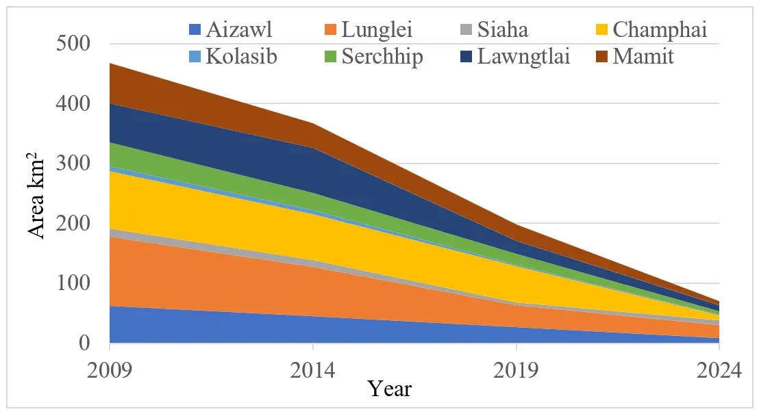
Figure 4 illustrates the area under shifting cultivation across all districts of Mizoram. The largest area was recorded in Lunglei, followed by Champhai and Lawngtlai. These were followed by Mamit, Aizawl, and Serchhip. The smallest areas under shifting cultivation were observed in Siaha and Kolasib. Overall, the trend shows a steady decline in shifting cultivation across the state, with a marked reduction in 2024 in all districts.
5.2. Percentage of Area Under Shifting Cultivation Out of the Total State’s Arable Land
We analyzed the percentage share of each district in the total area under shifting cultivation in Mizoram across different years (Figure 5). In 2009, Lunglei (24.70%) and Champhai (20.57%) accounted for the highest shares of shifting cultivation, and these districts consistently maintained the largest proportions in subsequent years. Aizawl, Lawngtlai, and Mamit districts also had substantial percentages, while Kolasib, Siaha, and Serchhip recorded the lowest. This overall pattern remained consistent across all four study years.
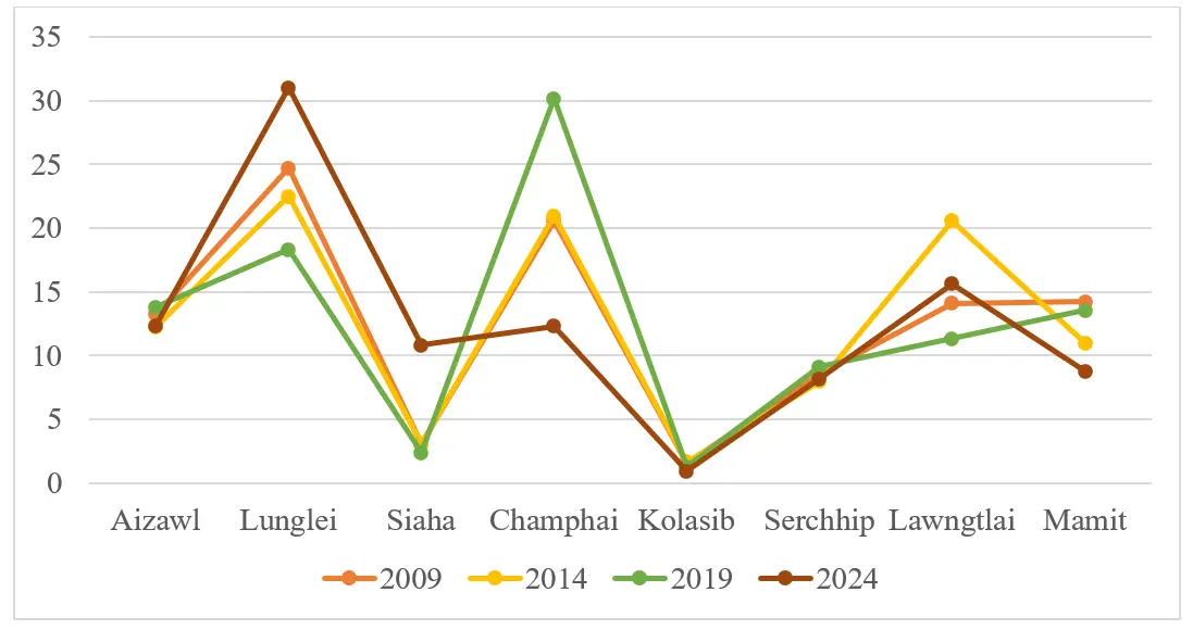
Figure 5. Percentage of area under shifting cultivation out of the total shifting cultivation area of the state.
Figure 6 shows the declining trend in the area under shifting cultivation from 2009 to 2024. The total area decreased from 467.35 km2 in 2009 to 69.72 km2 in 2024, representing an overall reduction of approximately 85.1%.
5.3. Burn Area of Shifting Cultivation in Mizoram
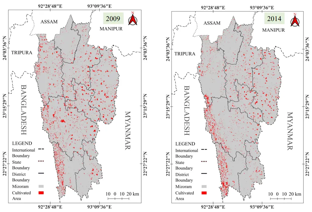
Satellite data on burnt areas for four different years—2009, 2014, 2019, and 2024—were analyzed and presented (Figure 7 and Figure 8). In 2009, all districts had extensive burnt areas, with dense patches observed in Mamit, Champhai, Serchhip, Aizawl, and Lunglei districts. A particularly dense patch of burnt area was also recorded in the western part of Lawngtlai district, along the border with Bangladesh. In contrast, Siaha and Kolasib districts had almost no burnt area.
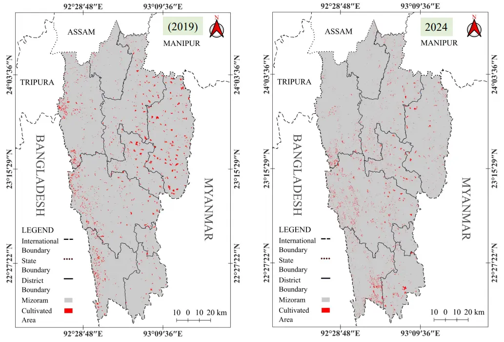
By 2014, the burnt area had declined substantially, especially in Mamit and Lunglei districts, while other districts also showed noticeable reductions. Compared to 2014, the extent of burnt areas in 2019 revealed an even larger decline across nearly all districts, with the most significant reductions occurring in Mamit, Aizawl, Serchhip, Lunglei, and Lawngtlai. Champhai also recorded a substantial decrease during this period. In the most recent year (2024), burnt areas associated with shifting cultivation were almost entirely absent. Except for small patches in Lunglei and Serchhip districts, the burnt area under shifting cultivation had become negligible.
5.4. Composite Burn Area of Shifting Cultivation
The composite burnt area of shifting cultivation in Mizoram is shown in Figure 9. Densely burnt areas are concentrated in the western part of the state along the border with Bangladesh, primarily in Mamit, Lunglei, and Lawngtlai districts. Moderately dense burnt areas are observed in Champhai, Serchhip, and parts of Lunglei. Sparsely burnt areas are found in Aizawl and Siaha, while the Kolasib district has a negligible area under shifting cultivation.
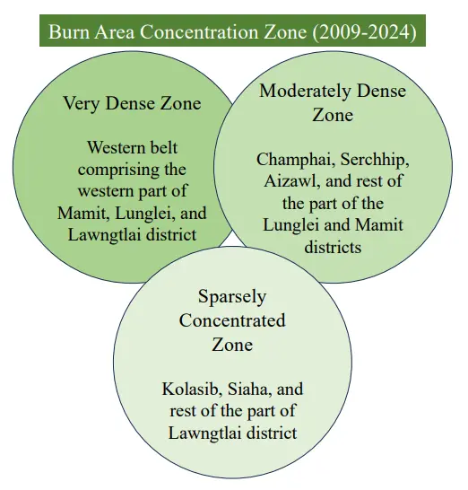
5.5. Burn Area Concentration Zones
Based on the composite burnt area shown in Figure 10, burn area concentration zones are classified into three categories: very dense, moderately dense, and sparse. The very dense zone is located in the western parts of Mamit, Lunglei, and Lawngtlai districts, along the border with Bangladesh. The moderately dense zone includes Champhai, Serchhip, Aizawl, and the remaining parts of Lunglei and Mamit districts. The sparse concentration zone comprises Kolasib, Siaha, and a small portion of the Lawngtlai district.
5.6. Changing Area Under Shifting Cultivation
The area under shifting cultivation has decreased in all districts of Mizoram (Table 2), although the rate of decrease varies by district. We analyzed data from 2009 and 2024 and calculated changes in both km2 and percentage. Overall, the total area under shifting cultivation in the state declined by 397.63 km2, representing an 85.1% decrease. The largest reductions were observed in Lunglei (93.81 km2), followed by Champhai (87.53 km2) and Mamit (60.47 km2). Lawngtlai (54.95 km2), Aizawl (53.29 km2), and Serchhip (34.41 km2) also showed notable decreases, while Siaha and Kolasib recorded reductions of less than 10 km2. In terms of percentage decrease, Champhai experienced the highest reduction at 91.1%, followed by Mamit and Kolasib at approximately 90% each. Aizawl, Serchhip, Lunglei, and Lawngtlai had decreases ranging between 80% and 87%. The lowest percentage decrease was observed in Siaha, at 47.1%.
Table 2. Changing area under Shifting cultivation.
|
District |
2009 |
2024 |
Change (km2) |
Change (%) |
|---|---|---|---|---|
|
Aizawl |
61.9 |
8.61 |
−53.29 |
−86.1 |
|
Lunglei |
115.44 |
21.63 |
−93.81 |
−84 |
|
Siaha |
14.26 |
7.54 |
−6.72 |
−47.1 |
|
Champhai |
96.13 |
8.6 |
−87.53 |
−91.1 |
|
Kolasib |
7.11 |
0.65 |
−6.46 |
−90.6 |
|
Serchhip |
40.1 |
5.69 |
−34.41 |
−85.8 |
|
Lawngtlai |
65.84 |
10.89 |
−54.95 |
−83.5 |
|
Mamit |
66.58 |
6.11 |
−60.47 |
−90.8 |
|
Total |
467.35 |
69.72 |
−397.63 |
−85.1 |
Source: Landsat 5 imagery for 2009, Landsat 8 for 2014 and 2019, and Landsat 9 for 2024.
The State of Mizoram has been transforming over the last decade in terms of the implementation of numerous infrastructural development projects. The most important projects include the construction of National Highways and railway lines. Every district headquarters has been connected by National Highways to Aizawl, the capital city of Mizoram. The highways are two-lane roads that traverse forest areas. Furthermore, shifting cultivation is practiced mainly in these forest areas; therefore, the area under shifting cultivation has decreased significantly. A detailed discussion of the drivers of changing shifting cultivation in Mizoram is elaborated below.
5.7. Exponential Growth/Decline Rate of the Area of Shifting Cultivation
Exponential growth/decline rate was calculated using the formula: Rate = (End/Start)1/(n − 1), where n is the number of years in the period. Four periods were analyzed based on the area under shifting cultivation: 2009–2014, 2014–2019, 2019–2024, and 2009–2024 (overall). Except for two instances—2009–2014 in Lawngtlai district and 2019–2024 in Siaha district, where a slight exponential growth was observed—all other periods exhibited exponential decline, with rates varying across districts.
Between 2009 and 2014, the decline rate ranged from 9.7% in the Mamit district to 3% in the Kolasib district. From 2014 to 2019, it varied from 22.6% in Lawngtlai to 4.9% in Siaha. Between 2019 and 2024, the decline rate ranged from 22.4% to 9.8% across districts. Overall, the exponential decline rate increased over time—from 2009–2014 to 2014–2019, and then 2019–2024. The total exponential decline rate from 2009 to 2024 ranged from 14.9% to 4.2% (Table 3).
Table 3. Exponential growth/decline rate.
|
District |
2009–2014 |
2014–2019 |
2019–2024 |
2009–2024 |
|---|---|---|---|---|
|
Aizawl |
−6.2% |
−9.5% |
−20.6% |
−12.3% |
|
Lunglei |
−6.5% |
−15.2% |
−9.8% |
−10.6% |
|
Siaha |
−4.5% |
−15.9% |
+9.6% |
−4.2% |
|
Champhai |
−4.4% |
−4.9% |
−32.1% |
−14.9% |
|
Kolasib |
−3.0% |
−15.9% |
−24.1% |
−14.7% |
|
Serchhip |
−6.2% |
−9.6% |
−22.4% |
−14.5% |
|
Lawngtlai |
+2.8% |
−22.6% |
−15.6% |
−8.5% |
|
Mamit |
−9.7% |
−7.9% |
−19.6% |
−13.2% |
|
Total |
−4.8% |
−11.1% |
−19.1% |
−11.4% |
Source: Landsat 5 imagery for 2009, Landsat 8 for 2014 and 2019, and Landsat 9 for 2024.
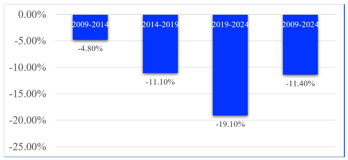
The overall exponential rate of change in the area under shifting cultivation in Mizoram was analyzed (Figure 11). It was observed that the rate of decline increased over the study period. The exponential decline rate rose from approximately 5% between 2009–2014 to around 11% in 2014–2019, and reached nearly 19% in 2019–2024. The overall decline over the entire period from 2009 to 2024 was estimated at 12–13%.
5.8. Drivers and Consequences of Declining Shifting Cultivation
This study by the Department of Agriculture, Government of Mizoram shows that the area under shifting cultivation is declining. Data from the last 40 years depict that over 50% of the area under shifting cultivation has decreased. The present study, which is based on data extracted from satellite imageries, reveals that more than 90% of the area under shifting cultivation has decreased from 2009 to 2024 in Mizoram [26]. At the district level, the decreased area is almost equal, with only small variations. The reasons for the decrease in the area under shifting cultivation are many, such as climate variability and change, reducing fallow cycles, decreasing production and productivity, increasing population, education, lack of market availability, and easy access to jobs in the service sectors—both public and private [27,28].
Climate variability and change have been identified as major factors contributing to the decline of shifting cultivation. In the recent past, a decrease in rainfall and an increase in temperature, coupled with high variability, have been observed. Shifting cultivation is rainfed and fully dependent on rainfall. High variability and reduced rainfall have led to declining crop production and productivity, causing Jhumias to abandon land under shifting cultivation [29,30,31,32]. In the past, the Jhum cycle was 20–25 years, which has now been reduced to 3–5 years, primarily to grow more crops in a shorter period. Since the Jhumias do not apply fertilizers, the reduced Jhum cycle has decreased soil fertility. The population in the rural areas of Mizoram is increasing, while the land under shifting cultivation is limited and changing. Consequently, production is insufficient to feed the growing population.
Mizoram is the first state in India to achieve 100% literacy. Furthermore, the level of education continues to rise. Educated youth are unwilling to work in traditional Jhumlands and instead seek jobs elsewhere. Market access is also a major problem. Products from Jhumlands are generally insufficient for sale and are mostly consumed by the producers themselves. Meanwhile, commercial crops—fruits and vegetables—have some potential, but during the season when they are ready for sale, market facilities are inadequate, and in many instances, crops are destroyed in the Jhum fields [33]. In recent times, the service sector has expanded, providing jobs to educated youth, while government employment opportunities are also available. The youth prefer to work in the service sector because incomes are higher and the work is easier than farming in remote Jhumlands.
The consequences of declining shifting cultivation are evident in multiple ways. As this study shows, more than 90% of the area under shifting cultivation has decreased over the past 15 years. Concurrently, forest area decreased by up to 6% from 2011 to 2019. This indicates that fallow land under shifting cultivation has been abandoned and has become barren, further leading to land degradation and severe soil erosion. Socio-cultural practices associated with shifting cultivation have also diminished. The burning and lashing of grasses and bamboos have decreased, resulting in a decline in the natural regeneration of various floral species.
Figure 12 depicts the socio-economic and environmental impacts of shifting cultivation in Mizoram. The output from the farmland is very marginal. The authors observed that after continuously working on a farmland for about eight months, a Jhumia produced only four pumpkins. On the other hand, burning the Jhumland resulted in forest degradation and severe soil erosion. The fallow land often became degraded land.
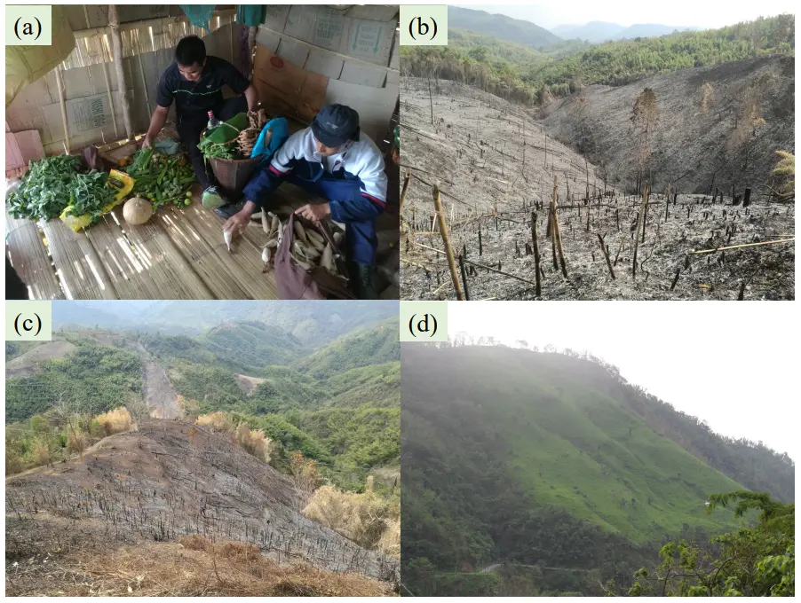
Figure 12. (a) Small products of vegetables; (b) Burn bamboo forest; (c) Brun forest patches, and (d) Fallow Jhumland converted into degraded land after several years. Photo by Vishwambhar Prasad Sati.
6. Discussion
Shifting cultivation has been a way of life and a socio-cultural activity for the people of Mizoram. Traditionally practiced, its production has been primarily subsistence-based. In the past, more than 80% of the rural population across all districts, except Kolasib and Siaha, practiced shifting cultivation. It was the main occupation, the major source of income, and a key livelihood option. This practice was closely associated with local culture and society, with many fairs and festivals linked to the agricultural cycle. People performed all festivals during the burning, sowing, and harvesting seasons. Chapchar Kut, an important festival, was celebrated in April during seed sowing in Jhumland [14,34].
Over time, however, the practice of shifting cultivation has decreased significantly in Mizoram. This study reveals that over 80% of the area under shifting cultivation has been lost in the past 15 years, leading to a corresponding decline in crop production [35,36]. Jhumias reported that the small remaining areas for cultivation hold little economic importance, and much of the remaining land is now maintained for cultural purposes. Shifting cultivation has similarly declined in tropical and subtropical regions worldwide, including Africa, South America, and Southeast Asia [37,38]. In Vietnam, for example, areas previously under shifting cultivation have been converted into modern agriculture, with sloping lands transformed into terraced fields [29]. Shifting cultivation has also declined in other parts of India [2,39].
The main objective of this study was to examine the major drivers and implications of declining shifting cultivation in Mizoram. Several drivers were identified, including climate variability and change, decreasing Jhum cycles, declining crop production and productivity, inadequate market access, rising population, increasing education, and the availability of private and government jobs. In 1985, the State Government of Mizoram introduced the ‘New Land Use Policy’, which aimed to provide permanent land allotments to Jhumias, replacing traditional shifting cultivation. This policy continued until 2005, when a change in government led to its abolition [4]. Consequently, interest in practicing shifting cultivation among Jhumias declined [40].
During the field visits, the authors observed that the burned areas had decreased and that old patches of shifting cultivation plots were highly degraded. The land was found to be unsuitable for both shifting cultivation and forest regeneration. Therefore, although the area under shifting cultivation has declined significantly, forest cover has also been decreasing. The interviewed heads of households shared similar views. They perceived that the population is increasing and that, due to high climate variability, output from shifting cultivation has declined. As a result, many marginal farmers have abandoned their shifting cultivation plots. The interviewees further opined that, with the availability of higher-paying daily wage opportunities in urban centres, many youths are shifting towards small businesses and employment in both the public and private service sectors.
7. Conclusions
Shifting cultivation remains a major livelihood option for the people of Mizoram, with more than 70% of rural households depending on it for their subsistence. However, our study found that between 2009 and 2024, the area under shifting cultivation declined by more than 80%. The largest reductions were observed in four districts of Mizoram—Kolasib, Lawngtlai, Saiha, and Lunglei—primarily due to the high rate of infrastructural development projects in these areas. Low crop production and productivity under shifting cultivation, high climate variability and change, increasing population, and higher income from the tertiary sector are some of the important factors contributing to the decline in shifting cultivation, as depicted in our study. Jhumias, being marginal farmers, have few alternative livelihood options. Reduced areas under shifting cultivation have led to food insecurity. Converting the remaining shifting cultivation land into permanent arable land could allow Jhumias to develop sustainable agriculture. Cultivation of commercial crops on these lands would increase rural incomes and contribute to economic development, thereby enhancing livelihood sustainability and food security. Mizoram has a suitable climate and rich agrobiodiversity, providing a strong base for the cultivation of both cereals and commercial crops. Crops such as banana, orange, pineapple, and papaya, along with a variety of vegetables, are already grown here at a subsistence level. This needs to be enhanced to a commercial scale. Although the arable land is limited, accounting for only about 5% of the total area, a large portion of it is under shifting cultivation. This land can be managed more efficiently for the cultivation of both cereals and commercial crops, thereby promoting sustainable agriculture and enhancing livelihoods.
Acknowledgments
The authors wish to thank all who assisted in conducting this work.
Author Contributions
K.L. collected data and prepared maps and V.P.S. wrote the manuscript and edit it.
Ethics Statement
Not applicable.
Informed Consent Statement
Not applicable.
Data Availability Statement
The datasets are not available.
Funding
This research received no external funding.
Declarations conflict of interest
The authors declare that they have no known competing financial interests or personal relationships that could have appeared to influence the work reported in this paper.
References
-
Pyone K, Crego R, Ngwe S, Win S, Connette K, Songer M, et al. Understanding the transition of community land use from shifting cultivation to cash cropping in southern Tanintharyi, Myanmar. People Nat. 2024, 6, 1130–1142. DOI:10.1002/pan3.10631 [Google Scholar]
-
Thangjam U, Thong P, Sahoo SS, Sahoo UK. Risk assessment of the jhumi as in eastern Himalayan region: An IPCC framework approach. Int. J. Disaster Risk Reduct. 2024, 108, 104575. DOI:10.1016/j.ijdrr.2024.104575 [Google Scholar]
-
Sati VP. Prospects of Oil Palm Plantation in Mizoram, India. J. Hill Farming 2017, 30, 139–143. Available online: https://ijhfonline.org/index.php/ijhf/article/view/269 (accessed on 26 December 2025).
-
Sati VP. The Potential of Wet Rice Cultivation in Mizoram, India: A Study of its Self-Sufficiency in Food Grain. J. Rice Res. 2020, 13, 27–38. Available online: https://www.researchgate.net/profile/Vishwambhar-Sati/publication/352480553_The_Potential_of_Wet_Rice_Cultivation_in_Mizoram_India_A_Study_of_its_Self-Sufficiency_in_Food_Grain/links/60cb39e992851ca3aca7f5c0/The-Potential-of-Wet-Rice-Cultivation-in-Mizoram-India-A-Study-of-its-Self-Sufficiency-in-Food-Grain.pdf (accessed on 26 December 2025).
-
Panda BK, Sharkar S. Shifting cultivation in northeast India: Growth and Progress. Dera Natung Gov. Coll. Res. J. 2017, 2, 69–90. DOI:10.56405/dngcrj.2017.02.01.07 [Google Scholar]
-
Kalita HC, Baishya SK, Dutta P, Borah S, Ram V. Study on Shifting Cultivation Cycle (Jhum Cycle) in Mokokchung District of Northeast India Using Multi Temporal Satellite Data. Int. J. Environ. Clim. Change 2023, 13, 2023–2031. Available online: https://www.researchgate.net/profile/Dr-Borah/publication/382328851_Article_noIJECC105988_Original_Research_Article_Kalita_et_al/links/66980eba4a172d2988a969e8/Article-noIJECC105988-Original-Research-Article-Kalita-et-al.pdf (accessed on 26 December 2025).
-
Ramakrishnan PS. The Cultural Landscape and the Sustainability of Shifting Cultivation in North East India. In Man and the Biosphere Series; UNESCO & Oxford-IBH Publishing: New Delhi, India, 2001. [Google Scholar]
-
Jakovac CC, Dutrieux LP, Siti L, Peña-Claros M, Bongers F. Spatial and temporal dynamics of shifting cultivation in the middle-Amazonas river: Expansion and intensification. PLoS ONE 2017, 12, e0181092. DOI:10.1371/journal.pone.0181092 [Google Scholar]
-
Heinimann A, Mertz O, Frolking S, Egelund Christensen A, Hurni K, Sedano F, et al. A global view of shifting cultivation: Recent, current, and future extent. PLoS ONE 2017, 12, e0184479. DOI:10.1371/journal.pone.0184479 [Google Scholar]
-
NITI Aayog. Report of the Working Group on Shifting Cultivation: Towards a Transformational Approach; Government of India: New Delhi, India, 2018. [Google Scholar]
-
Kamakaula Y. The impact of climate change on shifting cultivation systems: Challenges and adaptation strategies. J. Neonatal Surg. 2025, 14, 52–58. Doi:10.52783/Jns.V14.1716 [Google Scholar]
-
Sati VP. Economic and Ecological Implications of Shifting Cultivation in Mizoram, India; Springer: Berlin/Heidelberg, Germany, 2019. [Google Scholar]
-
Sati VP. Food Security Status in Rural Areas of Mizoram, Northeast India. J. Mt. Sci. 2017, 14, 795–805. DOI:10.1007/s11629-016-4092-2 [Google Scholar]
-
Soni JK, Hota S, Shakuntala I. Jhum cultivation: The way of livelihood security for Mizoram Jeetendra. Indian Farming 2019, 69, 20–23. Available online: https://www.researchgate.net/profile/Jeetendra-Soni/publication/360166542_Jhum_cultivation_The_way_of_livelihood_security_for_Mizoram/links/62664bf71b747d19c2a5fb49/Jhum-cultivation-The-way-of-livelihood-security-for-Mizoram.pdf (accessed on 25 December 2025).
-
Grogan P, Lalnunmawia F, Tripathi SK. Shifting cultivation in steeply sloped regions: A review of management options and research priorities for Mizoram state, Northeast India. Agrofor. Syst. 2012, 84, 163–177. DOI:10.1007/s10457-011-9469-1 [Google Scholar]
-
Sati VP. Shifting cultivation in Mizoram, India: An empirical study of its economic implications. J. Mt. Sci. 2019, 16, 2136–2149. DOI:10.1007/s11629-019-5416-9 [Google Scholar]
-
Bhuyan R. Review note on shifting cultivation in Northeast India amidst changing perceptions. Dhaulagiri J. Sociol. Anthropol. 2019, 13, 90–95. DOI:10.3126/dsaj.v13i0.24252 [Google Scholar]
-
Bose P. Oil palm plantations vs. shifting cultivation for indigenous peoples: Analyzing Mizoram’s Mizoram’s new land use policy. Land Use Policy 2019, 81, 115–123. DOI:10.1016/j.landusepol.2018.10.022 [Google Scholar]
-
Zodinpuii B, Lalnuntluanga, Lalthanzara H. Diversity of soil macro arthropods in shifting cultivation and forest ecosystem of Mizoram, Northeast India. J. Appl. Nat. Sci. 2019, 11, 601–611. DOI:10.31018/jans.v11i3.2122 [Google Scholar]
-
Chaudhury SK, Sarkar S. Shifting cultivation in North-Eastern India: A comparative analysis. Stud. Indian Place Names 2020, 40, 2732–2740. Available online: https://www.researchgate.net/profile/Sukanta-Sarkar-2/publication/341149671_Shifting_Cultivation_in_North-Eastern_India_A_Comparative_Analysis/links/6492efd98de7ed28ba4289b8/Shifting-Cultivation-in-North-Eastern-India-A-Comparative-Analysis.pdf (accessed on 25 December 2026).
-
Wapongnungsang, Ovung E, Upadhyay KK, Tripathi SK. Soil fertility and rice productivity in shifting cultivation: Impact of fallow lengths and soil amendments in Lengpui, Mizoram, Northeast India. Heliyon 2021, 7, e06834. DOI:10.1016/j.heliyon.2021.e06834 [Google Scholar]
-
Sharma SB, Kumar S, Ovung EY, Konsam B. Vegetation dynamics and soil nutrients across different shifting cultivation fallows in montane subtropical forest of Mizoram, NE India. Acta Oecologica 2022, 115, 103833. DOI:10.1016/j.actao.2022.103833 [Google Scholar]
-
MIRSAC. Mizoram Remote Sensing Application Centre Report on Climate of Mizoram; MIRSAC: Aizawl, India, 2022. [Google Scholar]
-
FSI. Forest Survey of India Report on State Forest Survey; FSI: Dehradun, India, 2023. [Google Scholar]
-
Sati VP. Changes in Farming Systems and Livelihood Patterns in Mountainous Region of Mizoram, Eastern Extension of the Himalaya. Indian J. Hill Farming 2015, 28, 111–120. Available online: https://agris.fao.org/search/en/providers/122648/records/64747360a4e07c0bc4c0244f (accessed on 25 December 2025).
-
Sati VP. New Land Use Policy and its Contribution in Sustainable Permanent Agriculture in Mizoram. Indian J. Hill Faming 2020, 113–120. [Google Scholar]
-
Bruun TB, de Neergaard A, Lawrence D, Ziegler AD. Environmental consequences of the demise in swidden cultivation in Southeast Asia: Carbon storage and soil quality. Hum. Ecol. 2009, 37, 375–388. DOI:10.1007/s10745-009-9257-y [Google Scholar]
-
Dressler WH, Wilson D, Clendenning J, Cramb R, Keenan R, Mahanty S, et al. The impact of swidden decline on livelihoods and ecosystem services in Southeast Asia: A review of the evidence from 1990 to 2015. Ambio 2017, 46, 291–310. DOI:10.1007/s13280-016-0836-z [Google Scholar]
-
Castella JC, Boissau S, Thanh NH, Novosad P. Impact of forestland allocation on land use in a mountainous province of Vietnam. Land Use Policy 2006, 23, 147–160. DOI:10.1016/j.landusepol.2004.07.004 [Google Scholar]
-
Cramb RA. Shifting cultivation and sustainable agriculture in East Malaysia: A longitudinal case study. Agric. Syst. 1993, 42, 209–226. DOI:10.1016/0308-521X(93)90055-7 [Google Scholar]
-
Cramb RA, Colfer CJP, Dressler W, Laungaramsri P, Le QT, Mulyoutami E, et al. Swidden transformations and rural livelihoods in Southeast Asia. Hum. Ecol. 2009, 37, 323–346. DOI:10.1007/s10745-009-9241-6 [Google Scholar]
-
Lal R. Shifting cultivation versus sustainable intensification. In Reference Module in Earth Systems and Environmental Sciences; Elsevier: Amsterdam, The Netherlands, 2015. DOI:10.1016/B978-0-12-409548-9.09295-2 [Google Scholar]
-
Nath AJ, Reang D, Sileshi GW. The shifting cultivation juggernaut: An attribution problem. Glob. Chall. 2022, 6, 2200051. DOI:10.1002/gch2.202270081 [Google Scholar]
-
Lalthangliana B. The Mizos: Society and Social Change 1890–1947; Mizoram Publication Board: Aizawl, India, 2005. [Google Scholar]
-
Lawmchullova I, Lalngaihawma J, Khumbah AL, Rinkimi L, Sati VP, Saitluanga BL, et al. Unravelling spatio-temporal rainfall variability in the Tlawng watershed, Mizoram under a tropical monsoon regime. Discov. Geosci. 2026, 4, 13. DOI:10.1007/s44288-025-00382-5 [Google Scholar]
-
Ramakrishnan PS. Shifting Agriculture and Sustainable Development: An Interdisciplinary Study from North-Eastern India; UNESCO: Paris, France, 1992. [Google Scholar]
-
Banerjee S, Sati VP. Forest Fires, Shifting Cultivation, and Cultural Identity: A Study of Chapchar Kut Festival as Key to Sustainability in Mizoram. In The Himalayan Whisperings: Dynamics and Challenges of Development in the Mountains; Semwal & Kumar, Ed.; Manohar Publishers and Distributers: Delhi, India; 2025; pp. 401–421. [Google Scholar]
-
Otsuka K, Place F, Takasaki Y. Land Tenure and Natural Resource Management: A Comparative Study of Agrarian Communities in Asia and Africa; Johns Hopkins University Press: Baltimore, MD, USA, 2001. [Google Scholar]
-
Shiva V. Social, environmental and ecological costs of commercialisation of agriculture in India. Ecol. Econ. 1995, 13, 95–109. [Google Scholar]
-
Sati VP. Reconciling the Issues of Shifting and Permanent Cultivation: An Empirical Study of Mizoram, Eastern Extension of Himalaya, India. Caraka Tani J. Sustain. Agric. 2022, 37, 171–184. DOI:10.20961/carakatani.v37i1.59407 [Google Scholar]