Evaluating UAS Integration into Geoinformatics: An Operational, Regulatory and Policy Analysis in Greek Geoinformatics Service Providers

Evaluating UAS Integration into Geoinformatics: An Operational, Regulatory and Policy Analysis in Greek Geoinformatics Service Providers
Received: 16 December 2025 Revised: 26 December 2025 Accepted: 05 February 2026 Published: 25 February 2026

© 2026 The authors. This is an open access article under the Creative Commons Attribution 4.0 International License (https://creativecommons.org/licenses/by/4.0/).
1. Introduction
In recent years, technological advances have significantly contributed to the development and adoption of innovative methods for collecting, managing, and using spatial data. More specifically, the integration of unmanned aerial vehicles (UAS) into geoinformatics technologies, namely Geographic Information Systems (GIS), remote sensing, and spatial analysis, has enforced data accuracy, efficiency, and flight safety. This evolution is marked by a significant shift towards the use of more automated, flexible, and cost-effective systems that collect and analyze spatial data in real time.
UAS use now covers a wide range of applications, including mapping, inspection of critical infrastructure and the environment, agricultural production, and management of natural and climate crises. The use of such technologies strengthens the ability of actors to interconnect complex spatial data and detect their dynamic interactions. The ability to collect high-resolution spatial data in real time, accurate georeferencing and rapid information processing enables businesses to monitor and analyze critical processes with greater accuracy and speed in critical business processes. Furthermore, there is a need for internationally harmonized regulatory frameworks that ensure flight safety, operational efficiency, and compliance with European and/or American standards.
At the international level, the International Civil Aviation Organization (ICAO) establishes the basic principles and guidelines for integrating UAS into international airspace. At a regional level, organizations such as the European Union Aviation Safety Agency (EASA) and the Federal Aviation Administration (FAA) are developing specialized regulatory frameworks that ensure the safe integration of UAS into their airspace. Despite significant progress in this field, international research shows a limited number of studies that have focused on the impact of drone-based geoinformatics on operational efficiency [1,2], and on UAS regulatory compliance.
Most studies are oriented toward technical or individual application areas [3,4], while few examine how businesses support the practical use of geospatial technologies and drones to collect spatial data [2]. Furthermore, the European UAS regulatory framework is evolving rapidly and creates new challenges for companies operating in the geospatial information sector. Despite the obvious technological progress in UAS–GIS, it remains unclear to what extent their integration improves companies’ operational efficiency while simultaneously enhancing regulatory compliance in a rapidly changing regulatory environment (EU). This dual dimension—efficiency and compliance—remains critical for the development of this specific sector, but has not been empirically explored, at least in the Greek context. Greece adopted national UAS regulations at an early stage (2016–2017) and subsequently, the harmonized European framework in 2020. Moreover, the Greek geoinformatics market is highly-fragmented and dominated by small and medium-sized enterprises. Consequently, it highlights the interaction between regulatory complexity and organizational capacity.
The purpose of this study is to explore how Greek companies operating in this field utilize these technologies to improve their operating efficiency and enhance their compliance with the applicable legal and regulatory framework, both at the national and European levels. The research is based on a multi-case study of five Greek companies that use GIS with UAS in various operational applications and aims to identify common practices, best policies, and challenges in the use of these innovative technologies. It seeks to find conclusions on how companies can combine technological innovation with regulatory compliance, ensuring data quality and flight safety while increasing operational efficiency. Next, the theoretical and conceptual framework of the study, the multiple case study methodology, and the data collection process are described. This is followed by a cross-case evaluation of the companies and an analysis of the findings. Finally, the main conclusions and limitations of the study are presented, along with directions for future research.
2. Background and Related Works
Published studies indicate the positive results (cost reduction, efficiency, improved decision-making, and real-time data acquisition) of integrating UAS into GIS. In particular, research by reference [1] examines this impact on urban planning, smart cities development, agriculture, and natural disaster management. Reference [5] analyse the US Secretary of Labor’s program, which aims to create geoinformatics scientists and develop UAS-GIS systems that map land areas. The use of drones in geoinformatics and cartography is also part of an academic program at the University of Budapest [6].
The reference [4] developed an operational framework for using UAS-GIS to monitor the conditions of amusement parks located within national parks. The reference [3] used drone-based remote sensing to create maps in order to deal with natural and cultural disasters in the developing areas of southwest China. Similarly, The reference [2] explored the design of UAS missions for geodata collection. These missions help collection of quality data in minimal time and cost. However, they conclude that effective mission organization is required, using appropriate software to plan the optimal flight route for efficient geodata collection.
The creation of highly accurate maps was examined by reference [7,8]. The use of advanced sensors by unmanned aircraft is particularly effective, enabling detailed mapping at low cost. Furthermore, unmanned aircraft can be used as platforms for collecting photogrammetric data in difficult-to-access areas, offering all the advantages mentioned above. The reference [9] explored the use of drones by geographers and their future contribution to the field.
The reference [10] used GIS to identify the dispersion and correlations of data from American manned aircraft pilots and UAS pilots sharing the same airspace. The aim is to identify high-risk geographical areas so that flight safety can be properly managed. The results of the research show that there is a high density of manned and unmanned flights near urban centers and airports, thus, the integration of GIS into air traffic management is considered very important.
Despite these advantages, studies also highlight some significant disadvantages in the use of drones by professionals involved in mapping. While collecting geodata via UAS is cheaper and provides higher resolution, professionals in the field (geographers, politicians, engineers, surveyors, etc.) are not willing to invest in technology that becomes outdated year after year [11]. Disadvantages such as the limitation of flights only under visual contact, short autonomy, and the high cost of high-resolution cameras force professionals to purchase data from intermediaries and contractors. These disadvantages act as deterrents to the use of UAS in areas increasingly prone to flooding, due to climate change or other extreme weather events. The reference [12] proposed a flood risk management framework map integrating drones into GIS and a decision-making model that contributes to flood risk analysis.
Significant studies have also been published concerning the training and skills of UAS operators, who are also mapping professionals [6,9,13,14,15]. These training programs prepare mapping professionals to become experienced drone pilots. In addition, they are trained to plan missions with UAS-GIS and to conduct high-level mapping. For example, civil engineering operators are required to be trained to create 3D models using UAS to capture the dimensions of buildings [14].
These articles so far have focused mainly on the technological potential of UAS-GIS use, with the advantages and disadvantages that may arise. Although international research offers partial documentation of the advantages and disadvantages of UAS–GIS at the level of operational effectiveness, there are no corresponding empirical studies in the Greek context. This gap limits understanding of the Greek market and the practices adopted in real business conditions. Therefore, it addresses this gap by adopting an organizational and regulatory perspective of UAS integration not as a technical challenge but as a socio-organizational process formed by governance structures, compliance capacity, and managerial decision-making of geoinformatics service providers.
3. Methodology
This research adopts a qualitative approach, aiming to investigate the operational effectiveness and regulatory compliance of companies in the field of UAS-GIS. The choice of analytical qualitative methodology was deemed appropriate, as the objective is an in-depth understanding of perceptions, policies, and operational strategies rather than statistical generalization. The study employs a multi-case design, which is suitable when examining complex phenomena and responding to how and why questions [16].
That method allows for the comparative investigation of the approaches adopted by different firms’ practices, in order to highlight common patterns, similarities, and differences, and potentially build best practices. Each company represents an autonomous case, while the results are comparatively assessed on a cross-case level. In this way, the phenomena are examined in depth, without losing the individuality of each case study. By studying multiple cases, the phenomena under investigation can be analyzed in depth as each case has distinct characteristics [17].
According to the reference [18], multiple case studies can provide a sound basis for grounding theory as they generate extensive qualitative data. They are certainly more effective than a single case study, although only careful design can achieve the expected outcomes. In addition to qualitative thematic analysis, the study incorporates indicative quantitative evidence derived from the interview material. Specifically, interviewees were asked to estimate relative changes in project duration and implementation cost following the adoption of UAS-based workflows. These estimates are self-reported and not independently audited. Yet, they are used to support cross-case pattern identification rather than precise measurement.
3.1. Research Design and Approach
The main method of collecting primary data is semi-structured interviews with the relevant project managers or directors of the five firms. The choice of that method aims to capture experiences, strategies, and practices while maintaining sufficient flexibility to allow new topics to emerge during the interview.
Each semi-structured interview includes central thematic axes, as follows:
-
-
operational processes and strategies for improving the collection and use of spatial data;
-
-
compliance practices with the regulatory framework of UAS and flight safety;
-
-
difficulties and obstacles in the operational use of UAS-GIS;
-
-
development of a suitable framework of best practices;
-
-
perceived challenges and future prospects.
The interviews lasted 45–60 min and were conducted in person or online (from 20 October 2025 to 20 November 2025) with the participants’ consent to audio recording and transcription. All data are anonymously and confidentially managed, as we mentioned in the previous section. Secondary data were collected for the selected companies prior to conducting these semi-structured interviews. These data were sourced both from the firms’ websites and from relevant scientific articles. Thus, triangulation is employed in this study, using multiple data sources to compare interview responses with secondary sources, in order to produce valid results, ensure consistency, and reduce interpretive bias.
Based on the purpose of the study, the research questions are formulated as follows:
-
What are the consequences of UAS integration on the operational operations and geospatial data production of geoinformatics service providers?
-
How do organizations ensure compliance with the national and European UAS regulatory frameworks when they collect geospatial data and execute missions?
-
What are the main challenges and difficulties faced by geoinformatics companies when they implement projects using UAS?
-
What are the best operational practices in the use of UAS that can be leveraged to improve efficiency and regulatory compliance?
3.2. Research Analysis
The analysis will be carried out using thematic content analysis. Initially, the interviews will be transcribed, and the interviewees’ responses will be grouped according to the thematic axes of the research questions. A cross-case analysis will then be conducted, aiming to identify common patterns, differences, and best practices among the five firms. The analysis will follow an inductive approach, allowing findings to emerge from the data without imposing predetermined theoretical frameworks [19].
Table 1 presents the content of the semi-structured interviews with executives of geoinformatics firms using UAS. The thematic axes were developed based on research questions.
Table 1. Thematic Axes of Semi-Structured Interviews.
|
Thematic Axis |
Dimensions |
Indicative Questions |
Purpose |
|---|---|---|---|
|
1. Operational Effectiveness |
Process effectiveness; data quality; technological adequacy; organizational flexibility; deliverables & customer value |
How are UAS-GIS projects organized? Which technologies/software are used? How is data accuracy ensured? How are roles allocated? How is client value assessed? |
Understanding operational organization, technological use, and effeciency factors. |
|
2. Regulatory Compliance |
Regulatory requirements (EASA/CAA); licensing & certification; risk management; data protection; internal controls |
Which regulations affect operations? What approvals are required? How is risk assessed? How is flight safety ensured? How is data privacy handled? |
Assessing integration of regulatory requirements and identifying compliance challenges. |
|
3. Challenges & Difficulties |
Technological limitations; regulatory constraints; organizational/financial barriers |
What are the main technological challenges? Are there regulatory restrictions? What internal difficulties affect UAS–GIS use? |
Identifying obstacles to operational efficiency and regulatory compliance. |
|
4. Best Practices & Prospects |
Successful practices; regulatory improvements; technological/organizational prospects |
Which practices are most effective? Useful regulatory projects? Useful regulatory changes? Future technol. developments? |
Documenting best practices and improvement proposals. |
An initial open-coding phase was conducted to identify concepts related to operational practices, regulatory compliance, and organizational challenges. These twenty (20) codes were grouped into seven (7) higher-order categories, including operational integration, regulatory compliance mechanisms, organizational structure, QA/QC practices, data governance, performance outcomes, and integration challenges, aligned with the research questions. It should be noted that the four thematic axes were used as an interview structuring framework, while the seven higher-order categories emerged inductively during the analytical phase and served as analytical constructs for thematic and cross-case analysis.
3.3. Cases’ Selection
Moreover, the Greek market of geoinformatics service providers utilizing UAS is relatively limited, comprising approximately 10–12 active firms. Therefore, the selection of the five (5) most prominent companies constitutes a representative sample. In the context of this study, five Greek companies active in geoinformatics using UAS were selected, either for their own project or as contractors providing services to other companies, under the following criteria:
-
-
have an active business activity in the collection and analysis of geospatial data for a considerable period of time;
-
-
use UAS in their business processes or as contractors on behalf of other companies;
-
-
implement or are required to implement the current European and national UAS regulatory framework;
-
-
were among the first companies to be licensed in 2017 as UAS operator training centers under the Greek regulatory framework (Government Gazette/B/4527/30-12-2016) [20];
-
-
their senior executives were willing to participate in our research through semi-structured interviews.
The real names of the five (5) selected firms are not published to ensure confidentiality and more objective responses from senior executives, who knew that none of the answers provided during semi-structured interviews would be published by name.
4. Presentation and Results
4.1. Firms
4.1.1. Firm A
Firm A is an organization providing training for drone pilots, certified as a Remote Pilot Training Center approval from the Hellenic Civil Aviation Authority in 2017, the year of its establishment. Since then, the firm has expanded by creating branches in various cities in Greece—beyond Athens and Piraeus—including Chania, Kalamata, Nafpaktos, and Messolonghi.
Today, it is one of the pioneering Greek enterprises in the field of UAS, having developed activities in the provision of geoinformation services and the development of remote sensing and high-accuracy mapping applications. It focuses on the collection, processing and analyzing of geospatial data through unmanned aircraft, undertaking infrastructure projects, environmental monitoring and precision agriculture. It is also the representative of the intuitive indoor drone ELIOS 2 by Flyability and the tethered UAS by ELISTAIR, in Greece and Cyprus.
The firm operates and executes geoinformatics projects on internal operational initiatives and on behalf of third parties as well. Its services cover the full spectrum of the geospatial lifecycle, including high-resolution surveying and mapping using UAS for primary data collection (RGB, multispectral and thermal), production of orthophotos and terrain models (DSM, DTM); photogrammetric and remote-sensing analysis such as the creation of three-dimensional surface models, spatial-change detection, thematic classification and image processing; GIS integration and spatial analysis combining UAS data with satellite and ground data to create integrated geospatial databases suitable for engineering projects, spatial planning, natural-resource management and environmental assessment; and the production of cartographic products and technical reports, delivering orthoimages, thematic maps and analytical documents with scientific documentation.
Finally, Firm A participates actively in EU-funded research projects that implement geoinformatics applications using UAS. Its participation in such projects demonstrates its strategic positioning as a highly specialized technical firm, aiming to incorporate UAS technologies into geospatial infrastructure, precision agriculture, and environmental management. Indicative examples of major projects include SmartVitiNet, which develops an integrated plant-health and precision-viticulture system using UAS; HECTOR, which focuses on ship inspection using unmanned aircraft and ultrasonic sensors; and Oenobotics, an innovative precision-spraying and remote-sensing system.
4.1.2. Firm B
Firm B is one of the most pioneering Greek companies in the field of UAS. Founded in 2011 in Chania, it also has offices in Athens. Since 2017, the company has been licensed as a Remote Pilot Training Center by the Hellenic Civil Aviation Authority and later became an approved UAS Training Center under the regulatory framework of EASA [21,22]. At the same time, the company is active in the fields of Intelligence, Surveillance & Reconnaissance (ISR), air transport, target acquisition, and geoinformation services, with strong involvement in projects related to infrastructure, the environment, crisis management and precision agriculture.
It has developed a complete range of geospatial surveying and remote-sensing services, providing solutions either as a contractor for third-party projects or to support its own operational and research activities. Its activities include high-resolution surveying and mapping using unmanned aircraft equipped with RGB, multispectral and thermal sensors for the collection of primary data, processed into orthophotos, DSM (Digital Surface Model) and DTM (Digital Terrain Model); photogrammetry and LiDAR for the creation of three-dimensional surface models, spatial-change detection, thematic classification and volume calculations essential for engineering and environmental projects; GIS integration and spatial analysis through the combination of aerial, satellite and ground data to produce comprehensive geospatial databases suitable for urban planning, infrastructure, natural-resource management and precision agriculture; and the production of cartographic products, delivering thematic maps and detailed technical reports with full scientific documentation.
These services establish Firm B as an important provider of technical geoinformation solutions, combining UAS technology, high-precision sensors, and GIS systems. It also participates actively in international research and development projects involving the integration of UAS into critical missions, including a Memorandum of Understanding with the Naval Group for the integration of the heavy-lift drone ATLAS 8 into naval platforms, as well as participation in operational and research programs with European Union entities such as the European Maritime Safety Agency and Frontex in the fields of surveillance, crisis management and GIS.
4.1.3. Firm C
Firm C is a Greek company based in Thessaloniki, founded in 2002 as a trading company specializing in UAS systems, geoinformatics and related equipment. Over time, its original commercial activity was expanded into services, system design, technical support, R&D, and training. Since 2017, it has operated as a certified UAS remote pilot training center.
It maintains a 350 m2 main facility in Thessaloniki, along with new laboratory and training infrastructures. It offers a wide range of services, especially in the field of geoinformatics, spatial data, and UAS, both as a contractor and for its own applications. Its major areas of activity include UAS systems and equipment, trading, design and development of UAS, distribution and support of international drone brands such as senseFly, Parrot, DJI, and SkyWatch; and official partnerships as a service center for senseFly, a tester for SkyWatch, and an authorized DJI representative in Northern Greece. It also provides technical support and maintenance services, including support for GNSS receivers, maintenance and upgrades of UAS and geoinformatics equipment and software.
In the domains of mapping, imaging, and geoinformatics services, it provides geodetic surveys, mapping and 3D modelling, precision agriculture applications, infrastructure inspections, and environmental monitoring. Its work includes photogrammetric surveys, UAS-based LiDAR operations, and remote sensing. The company is recognized as a “Pix4D Trainer”, allowing it to organize certified training seminars for the international photogrammetry software Pix4D. Its R&D activity includes participation in European projects and programs, such as ICAERUS, in which Firm C is a partner, providing UAS and geoinformatics solutions. It has established collaborations with public authorities, universities, research institutions, infrastructure companies, telecommunications providers, etc.
4.1.4. Firm D
Firm D is another Greek company operating in the field of unmanned aircraft systems (UAS). It was founded in 2015 in Athens, and describes itself as “the first company in Greece to operate in the field of unmanned ‘smart’ flying UAS systems”. The company implements international standards for quality environmental management, information security and health & safety.
It offers a wide range of UAS-related services, including drone design, construction, and operation, as well as data collection and analysis. In the field of geoinformatics in particular, it provides UAS design and production, along with aerial photography, mapping, and remote-sensing services; data-collection services and the analysis of specialized datasets such as thermal-camera data for surveillance, mapping, and reconnaissance; and technical consulting, support, and maintenance for UAS capable of integrating geoinformatics applications such as mapping and remote sensing. Consequently, the company functions not only as a manufacturer and supplier of UAS but also as a contractor delivering geoinformatics services, supporting projects that require spatial data collection, mapping, analysis, and results delivery. It also has an international orientation and involvement in UAS markets and manufacturing, positioning it as one of the key players in the Greek UAS ecosystem.
4.1.5. Firm Ε
Firm E is a representative example of a Greek company that combines UAS remote-pilot training with professional geoinformatics services as a contractor for public and private sector projects. It was founded in 2014 as the first company in Greece to specialize systematically in providing UAS application services. In 2017, expanding its activities, it established its UAS remote-pilot training center, receiving certification from the Hellenic Civil Aviation Authority. By 2019, it had acquired a distinct role in the field of UAS services, equipment, and training.
Today, the firms provides consulting services, UAS construction solutions, and equipment to corporate clients and government bodies, as well as aerial inspections for renewable-energy projects, medium- and high-voltage networks, telecommunications towers, pipelines, bridges, dams, and other technical infrastructure. It operates as a provider of geospatial services, covering the entire lifecycle of spatial data from collection to analysis and delivery of specialized products.
It uses GIS for the collection, storage, processing, analysis, and visualization of spatial data, deploying both multirotor and fixed-wing UAS. Its capabilities include the production of 2D orthomosaics; creation of 3D models; photogrammetry and stereophotogrammetry; volume measurements such as stockpile estimation in quarries or mines; and the development of geographic databases for analysis and management.
The firm undertakes projects in fields such as urban planning, mining, agriculture, environmental monitoring, telecommunications, energy, surveying, real estate, and construction. Its ability to carry specialized sensors, cameras, and precision instruments on drones enables the production of spatially and temporally dense datasets for environmental and geophysical studies, with minimal disturbance to the environment. It also undertakes geospatial projects as a contractor, delivering final products—including orthoimages, 3D models, databases, and analytical reports—to public authorities, infrastructure companies, energy providers, and research organizations (See Table 2).
Table 2. Five (5) Geoinformation service providers in Greece.
|
Company |
Founded |
Headquarters/Branches |
Services |
Technologies/Sensors |
R&D |
|---|---|---|---|---|---|
|
Firm A |
2017 |
Athens, Piraeus, Chania, Kalamata, Nafpaktos, Messolonghi |
Photogrammetry, Remote Sensing, GIS, Mapping |
RGB, Multispectral, Thermal |
SmartVitiNet, HECTOR, Oenobotics |
|
Firm B |
2011 |
Chania, Athens (Gerakas) |
Mapping, LiDAR,GIS, ISR |
RGB, Multispectral, Thermal, LiDAR |
EU/EMSA/Frontex |
|
Firm C |
2002 |
Thessaloniki |
Mapping, LiDAR, Remote Sensing, 3D Modelling |
LiDAR, Multispectral, Hyperspectral, GNSS |
ICAERUS |
|
Firm D |
2015 |
Athens |
Aerial Imaging, UAS Design, Consulting |
IR & Thermal Sensors |
International Participation |
|
Firm E |
2014 |
Athens |
Orthomosaics, 3D Models, GIS |
Multispectral, Thermal |
Technical Projects |
4.2. Comparative Findings
Τhe comparative analysis of the practices adopted by the five Greek companies employing UAS-GIS is structured around four key dimensions: (a) operational efficiency, (b) compliance with the UAS regulatory framework, (c) the challenges and constraints encountered in UAS framework, and (d) the best practices emerging from the analysis (See Table 3).
Table 3. Cross-Case Comparison.
|
Dimensions |
Firm A |
Firm B |
Firm C |
Firm D |
Firm E |
|---|---|---|---|---|---|
|
Operational Processes |
Autonomous & manual flights, PIX4D/Metashape |
Most multi-layered workflow with central coordination |
Standardized workflow with GCPs, RTK/PPK |
ISO-based advanced workflows |
Automated DJI-based workflow |
|
Role Allocation |
Operational Manager and field teams; internal compliance |
5 structured departments incl. Compliance |
Operators, technicians, PM; no compliance unit |
ISO-based units incl. compliance |
Simplified roles; no compliance unit |
|
Data Management |
Metadata; data volume challenge |
Advanced data governance |
Metadata; challenges with data volume |
Strong data governance (ISO) |
Standard DJI-based management |
|
Regulatory Categories |
Open & Specific with SORA/PDRA |
Open & Specific with SORA/PDRA |
Open & Specific per project |
Open & Specific per project |
Mainly Open + simple Specific |
|
Regulatory Monitoring |
Systematic EASA monitoring |
Systematic EASA monitoring |
Through CAA/official sites |
Through CAA |
Through CAA |
|
Compliance Structures |
Internal compliance & reporting |
Compliance Department |
No formal compliance unit |
Compliance Department |
No compliance unit |
|
Technical Challenges |
Data volume + equipment upgrades |
Equipment upgrades + data volume |
Large data volume |
Open-source integration |
— |
|
Regulatory Challenges |
SORA rejection risk |
Frequent requirement changes |
Approval delays |
Approval delays |
Approval delays |
|
Market Challenges |
— |
High demand + stricter requirements |
Low-skilled providers |
Underuse of UAS potential |
— |
4.2.1. Operational Efficiency
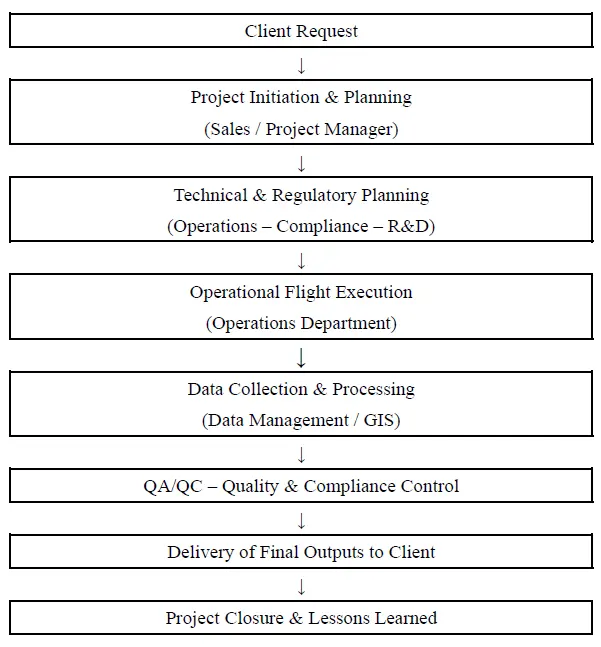
All firms implement standardized procedures for project planning and execution, including pre-flight planning, data collection, processing, analysis, and final product delivery—an indication of the sector’s overall maturity. Firm B and Firm D exhibit the most comprehensive and multilayered workflows, characterized by clearly defined roles and standardized QA/QC (Quality Assurance/Quality Control) processes. In addition, Firm B maintains centralized project coordination through its Project/Operations/Compliance Department (See Figure 1).
On the other hand, Firm D implements a Quality Management System in accordance with ISO-based standards. Firm C systematically uses GCPs, RTK/PPK, and predefined flight parameters to ensure accuracy in data collection. It also follows an organized processing and quality-control procedure, with emphasis on georeferencing, metadata, and completeness checks of the final outputs. Firm A follows an operational model based on a combination of autonomous and manual flights, using photogrammetric software (PIX4D, Agisoft Metashape) and advanced accuracy methods such as PPK, APK, and ground control points. Firm E applies a workflow focused on the DJI ecosystem and automated flight plans. Its workflow is characterized by automation, limited use of external photogrammetric software, and a high degree of standardization from preparation to final delivery.
All companies maintain distinct roles in project execution, involving UAS operators, GIS technicians, photogrammetrists, project managers, etc. Firm B has five clearly defined departments (Project Management/Sales, Operations, R&D, Production, and Compliance), which operate with well-specified responsibilities. The existence of an autonomous Compliance Department differentiates Firm B from all other companies, as it is the only case where monitoring regulatory changes, managing SORA/PDRA, and maintaining manuals and the SMS are assigned to a specialized internal team.
Firm D also follows a structured role allocation based on the requirements of certified quality management systems (ISO). It maintains distinct functional units for project design, fieldwork, processing, and quality assurance, as well as for compliance, making it the second most structured company after Firm B. Firm A applies a role distribution that ensures operational coordination and mission safety. The Operational Manager assigns personnel to two-member field teams, while UAS operators and photogrammetry technicians collect and process data. The company maintains internal compliance mechanisms and incident-reporting procedures; however, regulatory compliance is not institutionally separated into an independent department, as in Firm B.
Firm C distributes roles among UAS operators, field technicians, photogrammetrists, and project managers. Compliance with regulatory requirements is embedded in the project team’s operation and is not supported by a separate organizational unit. Firm E demonstrates the most simplified role allocation. Operators are responsible for both flight planning and execution, while processing technicians primarily use DJI software for producing deliverables. The project manager coordinates communication with clients. The company does not declare the existence of a separate compliance mechanism.
The firms show differentiated choices regarding photogrammetry software and processing tools. Firms C, B, and A use combinations of PIX4D and Agisoft Metashape, which are tools for producing orthophotos, 3D models, and digital terrain representations. Firm E relies exclusively on DJI Terra, leveraging its full integration with DJI systems for automated mission planning and data processing. In contrast, Firm D adopts a more flexible and open ecosystem of tools, using open-source software and pipelines such as QGIS, VisualSFM, CMVS–PMVS.
Regarding sensors and equipment, all firms use high-resolution RGB sensors for standard mapping and inspection missions. Firms A and B also integrate LiDAR sensors, enabling higher point density and improved performance in areas with complex geomorphological conditions. Firms C and D use multispectral sensors where required, mainly in environmental or agro-meteorological applications. Firm E uses DJI Enterprise equipment exclusively, maintaining a high degree of homogeneity and standardization across its operational platforms.
As far as georeferencing methods and GNSS accuracy techniques are concerned, Firms A and C apply combinations of RTK, PPK, and Ground Control Points (GCPs), enabling high geometric accuracy in their final products. Firm B also uses RTK/PPK, adjusting the method according to the technical requirements of each project. Firm D uses GCPs and custom accuracy-validation workflows, integrating error-checking procedures across multiple processing stages. Firm E relies mainly on the RTK capabilities of DJI models, using their embedded technology as the primary accuracy mechanism.
The firms implement procedures that include the use of metadata to document the collected data and the individual processing stages. Among all companies, Firms B and D have the most structured and systematic data-governance policies, with standardized practices for classifying and organizing data. Firms A and C report that managing the large volume of data generated during missions is a significant challenge, especially in large-scale or high-resolution projects. This finding primarily concerns the processes of data storage, processing and transfer between teams and software.
Regarding deliverables, all companies produce the main geospatial imaging products, including orthomosaics, Digital Elevation Models (DEM/DSM) and 3D models. Firm D differentiates itself by offering additional products such as Digital Twins and BIM-compatible data, expanding the range of its deliverables beyond classical photogrammetric outputs. Firm B delivers both processed products and raw data, allowing clients to choose the desired level of processing. Firm A notes that the accuracy requirements of deliverables vary significantly across clients, which leads to adaptation of technical specifications and quality-control procedures for each project.
4.2.2. Compliance with UAS Regulations
All firms operate both in the Open Category and the Specific Category of UAS, making use of the applicable regulatory framework of EASA and the HCAA for carrying out projects with different levels of risk [23]. Firms A and B systematically use PDRA and SORA procedures for managing high-risk missions, indicating their engagement in operations with increased complexity and requirements.
Firm E mainly operates in the Open Category and in simple missions within the Specific Category, relying primarily on predefined procedures without extensive risk activities. In contrast, firms C and D apply regulatory procedures on a project-by-project basis, adapting the requirements of the Specific Category to the particularities of each mission, without the use of specialized PDRA or SORA methodologies.
Firms A and B demonstrate the most systematic engagement with EASA updates, incorporating changes into their operational framework through regular monitoring and participation in relevant networks. The remaining companies—Firm C, Firm D, and Firm E—are informed mainly through the HCAA and official websites, without reference to an organized or continuous monitoring of European regulatory developments.
The presence of internal compliance structures significantly differentiates the companies. Firms B and D are the only ones that maintain Compliance Departments, which are responsible for managing regulatory requirements, monitoring changes to the regulatory framework, and maintaining the necessary documentation (manuals, SMS, risk assessments). In contrast, Firms C and E do not report specialized compliance units; their related functions are integrated into the project team. Firm A implements internal compliance controls and uses the HCAA portal for reporting and managing regulatory requirements.
4.2.3. Challenges and Difficulties
The comparative analysis of the five Greek firms highlights three dimensions of challenges: technical difficulties, constraints imposed by the UAS regulatory framework, and challenges arising from the structure and maturity level of the market in question. All firms identify the management of the large volume of data generated by photogrammetric and LiDAR missions as a key technical difficulty, especially in large-scale or high-resolution projects. Firms A and B additionally highlight the need for frequent equipment and sensor upgrades, as the rapid technological evolution of UAS requires continuous investment and adaptation. Firm D reports an additional technical challenge related to the difficulty of integrating open-source pipelines into demanding projects, due to the need for customized solutions and complex workflows.
At the regulatory level, all firms report delays in flight approvals from HCAA/CAA, which affects planning and timely project execution. Firm B notes that the frequent modifications to the requirements of the Specific Category at the European level create additional administrative burden and a need for continuous updates of documentation and procedures. Firm A reports an increased probability of SORA rejections in specific areas due to restrictive factors related to the flight environment and risk assessment.
Regarding market level, Firm C notes the presence of non-specialized providers who, due to low technical competence, degrade the overall quality of services in the sector. Firm D highlights that the market does not fully exploit the capabilities of UAS, resulting in low adoption of advanced analytical tools and limited use of the technology beyond basic applications. Firm B states that the increasing demand for UAS services is accompanied by the tightening of both technical and regulatory requirements, which affects planning and pre-operational preparation.
5. Discussion
The present comparative analysis of the five Greek companies highlights important aspects of the integration of UAS into GIS services in Greece (Bλέπε Table 4). According to relevant studies [1], the use of UAS in geospatial applications contributes to cost reduction, improved quality, and the provision of high-resolution geospatial data. All firms in the study declare significant percentage reductions in project duration and implementation cost. Indicatively:
-
-
Firm C: +150% productivity/−70% cost;
-
-
Firm D: 50–70% reduction in time/30–50% reduction in cost;
-
-
Firm B: 30–50% faster implementation/20–40% cost reduction;
-
-
Firms A and E indicate equally high performance gains compared to traditional methods.
These efficiencies stem from several interrelated factors: improved access to otherwise difficult or inaccessible areas, the automation of data acquisition processes, the enhanced analytical value of the produced outputs, and the capacity to repeat missions under consistent conditions. While the use of UAS in geoinformatics is often associated with reductions in time and operational costs, the comparative analysis demonstrates that such benefits do not emerge automatically with UAS adoption. Instead, overall performance is largely shaped by how regulatory obligations are embedded within everyday organizational routines.
Table 4. Factors’ analysis in five Greek Geoinformation service providers.
|
Company |
Strategic Orientation |
Workflow Characteristics |
Regulatory Compliance |
Key Challenges |
|---|---|---|---|---|
|
Firm A |
Technical precision & educational role |
Advanced workflows; strong R&D & training |
Medium–high; internal compliance |
Equipment upgrades; SORA/CAA delays |
|
Firm B |
UAS Center of Excellence; international outreach |
Standardized, integrated workflows; specialized departments |
High; independent compliance dept. |
High equipment upgrade cost |
|
Firm C |
Custom geoinformatics solutions |
RTK/PPK, GCPs, metadata QC |
Medium; less institutionalized |
Non-specialized competitors |
|
Firm D |
ISO-based QMS; international focus |
Advanced open-source workflows; smart flying systems |
High; structured compliance |
Open-source integration difficulties |
|
Firm E |
Integrated UAS solutions & training |
Automated DJI-ecosystem workflows |
Lower formal compliance |
DJI ecosystem compatibility limits |
Across the five cases examined, organizations that have invested in structured compliance capacity—either through dedicated compliance units or clearly defined roles and responsibilities—tend to integrate regulatory requirements more effectively into their operations. When this approach is combined with standardized end-to-end workflows and clearly established QA/QC checkpoints, these firms exhibit smoother project execution and deliverables of more consistent quality, particularly within the Open and Specific Categories. Moreover, robust data governance practices—such as systematic metadata documentation, controlled data storage, and regulated data transfer procedures—further reinforce repeatability and reliability in project outcomes.
Firms that address compliance in a more informal or case-by-case manner often rely on ad hoc arrangements and loosely defined role allocation. Under regulatory constraints, this organizational model is associated with greater operational performance variability and heightened vulnerability to approval delays. Such patterns underscore the importance of organizational maturity in translating regulatory compliance into operational effectiveness. Overall, the findings suggest that compliance should not be viewed merely as an administrative burden. It operates as a performance-enabling mechanism that links organizational maturity with both operational efficiency and flight safety. In addition, the analysis points to a progressive relationship between the level of regulatory compliance maturity and the consistency of UAS–GIS service provision.
The strategic orientation of each firm is directly related to its level of operational effectiveness. Firm B, aiming to establish itself as a European Center of Excellence for UAS, demonstrates a major competitive advantage through its integrated workflow, strict standardization, specialized departments, and multi-layered operational structure. This finding aligns with [2], which emphasizes the importance of standardized, integrated workflows for ensuring high data quality.
Firm D adopts an ISO-based Quality Management System and advanced workflows, fully aligned with international best practices. It utilizes “smart flying systems” as a vehicle for spatial data collection, processing, and analysis, with strong emphasis on quality, reliability, and strategic expansion into international markets. Firm A, strategically oriented toward high accuracy, technical specialization, and a strong educational role, implements combined advanced workflows and promotes innovation within the Greek UAS ecosystem. Its engagement with R&D and professional training is consistent with international studies that highlight the importance of technical expertise for producing high-quality geospatial data [5,6].
Firm C, strategically focused on providing custom geoinformatics solutions, employs workflows emphasizing accuracy (RTK/PPK, GCPs, metadata QC). This approach aligns with research that stresses the value of technological specialization for high-accuracy geospatial outputs [7]. Firm E, oriented toward delivering integrated UAS solutions and training professionals, implements automated workflows based on the DJI ecosystem, consistent with international trends in flight automation and optimization [4]. The strategic direction and organizational structure of these firms are shown to be critical success factors in the UAS–GIS domain.
Compliance with the regulatory framework is identified as the most critical factor for UAS flight safety [10,12], a finding strongly reflected in the present case study. Firms B and D, both maintaining independent Compliance Departments and multi-layered administrative structures, exhibit the highest level of regulatory maturity. Their emphasis on safety and provision of critical services (ISR, defense, infrastructure) drives increased investment in compliance. Conversely, companies such as Firm C and Firm E, whose strategies are focused primarily on technical solutions, appear to adopt less standardized compliance models—an observation consistent with studies noting that small and medium-sized enterprises often lack sufficient regulatory management mechanisms [11].
Firm A, with a dual strategic character (operational and educational), implements effective internal compliance mechanisms, although it does not maintain an independent department. As a training organization, it has comprehensive knowledge of the UAS regulatory framework, confirming international findings on the importance of education [13]. The delays in flight approval by the HCAA, SORA rejections in high-risk areas, and frequent changes in the Specific Category requirements reflect international results documenting significant bureaucracy and regulatory instability [21].
The findings in the Greek sector further confirm international evidence that the collection of large data volumes, high equipment costs, and the need for continuous upgrades constitute major challenges for drone-based geoinformatics providers [11]. However, the extent and nature of challenges faced by each firm are directly linked to their strategic orientation:
-
-
Firms A and B constantly face the need for equipment upgrades;
-
-
Firm D, relying on open-source development, experiences integration difficulties with pipelines;
-
-
Firm C, focused on specialized solutions, is affected by competition from non-specialized providers—consistent with findings on low market maturity in emerging sectors [9];
-
-
Firm E, oriented toward the DJI ecosystem, faces challenges mainly in compatibility rather than heterogeneous equipment management.
International literature [13,15] highlights that geoinformatics training is foundational for safe and accurate UAS missions. The present multi-case study findings reveal a clear correlation: companies with stronger geospatial expertise, certified UAS operators, and more organized structures (Firm B, Firm D, Firm A) also demonstrate higher regulatory consistency.
Although this study is empirically grounded in the Greek geoinformatics sector, its findings have broader relevance for UAS–GIS services provision in other European firms, operating under the harmonized EASA regulatory framework. The five Greek firms share regulatory obligations, operational categories (Open and Specific), and compliance mechanisms that are common across EU Member States, allowing analytical insights and an optimal framework that extends beyond national boundaries (See Table 5).
Finally, despite the operational benefits, the integration of UAS into geoinformatics workflows entails a series of technical, regulatory, and organizational trade-offs that constrain performance. This includes regulatory constraints (approval delays, frequently changing Specific Category requirements, SORA-related risks), technical challenges (data volume management, processing capacity), and organizational pressures (equipment upgrades, compliance workload).
Table 5. Guidelines for an optimal framework.
|
Thematic Axis |
Guidelines |
|---|---|
|
Operational Practices |
GIS-UAS efficiency is enhanced through standardized workflows, clear role allocation, systematic QA/QC procedures, and structured data management. |
|
Compliance & Regulatory Framework |
Regulatory consistency requires systematic documentation, monitoring legislative changes, and internal compliance mechanisms; less bureaucratic regulatory authorities are needed. |
|
Technical & Operational Challenges |
Large data volumes, equipment upgrade needs, and administrative delays directly impact operational efficiency. Continuous adaptation to technological developments is required. |
|
Role of Skills & Expertise |
Interdisciplinary knowledge (UAS, GIS, photogrammetry, remote sensing) and continuous training are critical for mission quality and safety. |
|
Overall Perspective |
Successful UAS integration in geoinformatics arises from the synergy of technology, organizational structure, regulatory competence, and workforce training. |
6. Conclusions
This study has shown that the integration of UAS in GIS is a complex process, influenced not only by the technological capabilities of the platforms or the quality of the sensors, but—above all—by the way in which operational practices are structured and implemented. The efficiency of UAS depends largely on the availability of standardized, clearly defined workflows that cover the entire project lifecycle, from mission planning to data processing and final delivery to the client. Quality-control procedures, metadata documentation, the use of specialized georeferencing methods, and organized data-management structures constitute fundamental mechanisms that ensure the accuracy and consistency of the generated geospatial products.
Regulatory compliance emerges as an equally important factor to technological infrastructure. Meeting safety requirements, monitoring regulatory developments, and systematically documenting procedures (SMS aligned with UAS standards, proactive PDRA/SORA preparation) determine the extent to which organizations can conduct UAS operations safely and consistently. The presence of internal compliance mechanisms, along with a clear understanding of the obligations under the Open and Specific Categories, facilitates the reduction of operational risk and enhances alignment with European regulatory requirements. Overall, the cases indicate that the way regulatory compliance is organized within the firm plays a key role in shaping the consistency and reliability of operational outcomes.
At the same time, the research reveals significant technical and operational challenges, most notably the management of large volumes of data, the need for continuous equipment upgrades, and administrative delays associated with flight approvals or frequent revisions to regulatory requirements. These challenges directly affect operational efficiency and highlight the need for more flexible, scalable, and technology-neutral approaches to workflow design, as well as less bureaucratic public-sector procedures.
The role of skills and professional expertise is of particular importance in the use of UAS for geospatial applications. Effective utilization of these systems depends not solely on pilot proficiency but requires interdisciplinary knowledge, including photogrammetry, remote sensing, geospatial analysis, and mission design and preparation. The quality of the data and the safe execution of flights are closely linked to the level of training, experience, and specialization of the teams involved.
Overall, the findings indicate that the successful integration of UAS in GIS depends on technology, organizational structure, and regulatory competence. Efficiency is strengthened through standardization, systematic documentation, and collaboration between technical and managerial roles, while regulatory compliance is achieved through internal control mechanisms and continuous training. The study highlights that UAS are not merely data-collection tools; rather, they require a comprehensive operational approach in which processes, people, and technology collectively determine the final quality and reliability of geospatial information. While the empirical focus of this study is Greece, the analysis provides insights relevant to a wider set of European geoinformatics service providers operating under a common European regulatory regime. The best practices adopted by the firms examined in this study may serve as a reference framework for the further development of the sector in Greece and as a basis for future research aimed at identifying and comparing similar practices at the European level.
Author Contributions
Conceptualization, A.T. and D.P.; Methodology, A.T.; Software, A.T. and D.P.; Validation, A.T. and D.P.; Formal Analysis, A.T. and D.P.; Investigation, A.T.; Resources, A.T. and D.P.; Data Curation, A.T. and D.P.; Writing—Original Draft Preparation, A.T.; Writing—Review & Editing, A.T. and D.P.; Visualization, A.T. and D.P.; Supervision, D.P.; Project Administration, D.P.
Ethics Statement
Ethical review and approval were waived for this study, as the research did not involve clinical interventions, experiments, or sensitive personal data. The study was based on expert interviews conducted on a voluntary basis with informed consent, focusing exclusively on professional experience and regulatory perspectives. All participants were anonymized, and no identifiable personal data were collected.
Informed Consent Statement
Informed consent was obtained from all subjects involved in the study.
Data Availability Statement
The data presented in this study are not publicly available due to ethical and confidentiality considerations related to the use of expert interviews. Data may be made available from the corresponding author upon reasonable request.
Funding
This research received no external funding.
Declaration of Competing Interest
The authors declare that they have no known competing financial interests or personal relationships that could have appeared to influence the work reported in this paper.
References
- Quamar MM, Al-Ramadan B, Khan K, Shafiullah M, El Ferik S. Advancements and Applications of Drone-Integrated Geographic Information System Technology—A Review. Remote Sens. 2023, 15, 5039. DOI:10.3390/rs15205039 [Google Scholar]
- Hutsul T, Lysko B, Zhezhera I, Tkach V, Tsvyk T. Recommendations for planning UAV flight missions for geodata collection. Rep. Geod. Geoinf. 2025, 119, 62–70. DOI:10.2478/rgg-2025-0007 [Google Scholar]
- Li Q, Deliberty T. Integrating drones, participatory mapping and GIS to enhance resiliency for remote villages. Trans. GIS 2022, 26, 818–838. DOI:10.1111/tgis.12886 [Google Scholar]
- Tomczyk AM, Ewertowski MW, Creany N, Ancin-Murguzur FJ, Monz C. The application of unmanned aerial vehicle (UAV) surveys and GIS to the analysis and monitoring of recreational trail conditions. Int. J. Appl. Earth Observ. Geoinf. 2023, 123, 103474. DOI:10.1016/j.jag.2023.103474 [Google Scholar]
- McKee T, Hashemi-Beni L. Developing geospatial scientists—Using students as partners in drone research. Int. Arch. Photogramm. Remote Sens. Spatial Inf. Sci. 2020, 44, 69–72. DOI:10.5194/isprs-archives-XLIV-M-2-2020-69-2020 [Google Scholar]
- Vörös F, Kovács B, Zentai L. The rising role of drones in the training of cartographers at Eötvös Loránd University (ELTE). Proc. ICA 2023, 5, 1–8. DOI:10.5194/ica-proc-5-23-2023 [Google Scholar]
- Budiharto W, Irwansyah E, Suroso JS, Chowanda A, Ngarianto H, Gunawan AAS. Mapping and 3D modelling using quadrotor drone and GIS software. J. Big Data 2021, 8, 48. DOI:10.1186/s40537-021-00436-8 [Google Scholar]
- Doumit JA. From Drones to Geospatial Data. KubGU, Krasnodar. Courtesy of assistant professor Steve Scott. 2018. Available online: https://d1wqtxts1xzle7.cloudfront.net/58391588/Doumit_2018-libre.pdf?1550044058=&response-content-disposition=inline%3B+filename%3DFrom_drones_to_geospatial_analysis.pdf&Expires=1771992096&Signature=P6jfg6z-3ZlC8~-IIHEPcXQc3Or8kYbcaOH2rvoPG28TEdJ9PIdnPzNYm7O3BFGN8xHrrgF-ncVRh5JzYpSCHcaM1PuHIDCTg~kmTLDtbCvmjpYQ5mrQVK8VPycXfdyGfQyow5xomDHILYw2AT-22TrIZnKSrcViDxwj2-0x1FCKD~02U0G~zznVh3Jg2BVLpwjxcGMkAPPGE41F4YOaI~iUzH8WZk4kstARG4omY3ZqQn2qEBEUIFgD-nLTaDwSlzffhGHq-GVnSXnp4jyK0oLYI8xPpZEEdJMKHRMs7e3jaJwKTt6c~7DGf98ghFn11q3q~HzkWbxBY-Iw4eRy8w__&Key-Pair-Id=APKAJLOHF5GGSLRBV4ZA (accessed on 12 December 2025).
- Rogers SR, Singh KK, Mathews AJ, Cummings AR. Drones and Geography: Who Is Using Them and Why? Prof. Geogr. 2022, 74, 516–528. DOI:10.1080/00330124.2021.2000446 [Google Scholar]
- Lercel DJ, Hupy JP. Exploring the Use of Geographic Information Systems to Identify Spatial Patterns of Remote UAS Pilots and Possible National Airspace Risk. Safety 2023, 9, 18. DOI:10.3390/safety9010018 [Google Scholar]
- McNeil B, Snow C. The Truth About Drones in Mapping and Surveying 2016. Available online: https://droneanalyst.com/wp-content/uploads/2016/12/TheTruthAboutDrones_mapping-1.pdf (accessed on 12 December 2025).
- Nazir MF, Atif S, Hussain E. An integrated geographic information system (GIS) and analytical hierarchy process (AHP)-based approach for drone-optimized large-scale flood imaging. Drone Syst. Appl. 2025, 13, 1–18. DOI:10.1139/dsa-2024-0039 [Google Scholar]
- Yang B, Hawthorne TL, Hessing-Lewis M, Duffy EJ, Reshitnyk LY, Feinman M, et al. Developing an Introductory UAV/Drone Mapping Training Program for Seagrass Monitoring and Research. Drones 2020, 4, 70. DOI:10.3390/drones4040070 [Google Scholar]
- Kováčiková N, Dědič M, Lorencová I. Geoinformatics, 3D Modelling of Buildings with Drones for Civil Engineering Experts. TEM J. 2025, 14, 35–43. DOI:10.18421/TEM141-04 [Google Scholar]
- Joyce KE, Meiklejohn N, Mead PCH. Using Minidrones to Teach Geospatial Technology Fundamentals. Drones 2020, 4, 57. DOI:10.3390/drones4030057 [Google Scholar]
- Adams CR, Barrio Minton CA, Hightower J, Blount AJ. A systematic approach to multiple case study design in professional counseling and counselor education. J. Couns. Prep. Superv. 2022, 15. Available online: https://research.library.kutztown.edu/jcps/vol15/iss2/24 (accessed on 12 December 2025).
- Yin RK. Case Study Research and Applications: Design and Methods; Sage Publications: Thousand Oaks, CA, USA, 2018. [Google Scholar]
- Eisenhardt KM, Graebner ME. Theory Building From Cases: Opportunities And Challenges. Acad. Manag. J. 2007, 50, 25–32. DOI:10.5465/amj.2007.24160888 [Google Scholar]
- Thomas DR. A General Inductive Approach for Analyzing Qualitative Evaluation Data. Am. J. Eval. 2006, 27, 237–246. DOI:10.1177/1098214005283748 [Google Scholar]
- Hellenic Civil Aviation Authority. Regulation on Training Centers and Licensing of Unmanned Aircraft Systems (UAS) Remote Pilots (Government Gazette B 4527/2016). Available online https://www.e-nomothesia.gr/kat-aerodromia- aeroporia/apophase-upa-d2-d-30005-12541-2016.html (accessed on 12 December 2025). [Google Scholar]
- European Union. Commission Implementing Regulation (EU) 2019/947 of 24 May 2019 on the Rules and Procedures for the Operation of Unmanned Aircraft. 2019. Available online: https://eur-lex.europa.eu/legal-content/ EN/TXT/?uri=CELEX:32019R0947 (accessed on 12 December 2025). [Google Scholar]
- European Union. Commission Delegated Regulation (EU) 2019/945 of 12 March 2019 on Unmanned Aircraft Systems and on Third-Country Operators of Unmanned Aircraft Systems. 2019. Available online: https://eur-lex.europa.eu/legal-content/EN/TXT/?uri=CELEX:32019R0945 (accessed on 12 December 2025).
- Tsotra A. Critical Comparative Analysis of UAS Legislative Developments. ISPRS Ann. Photogramm. Remote Sens. Spatial Inf. Sci. 2024, 10, 223–230. DOI:10.5194/isprs-annals-X-4-W4-2024-223-2024 [Google Scholar]