1. Introduction
According to experts, if humanity does not rapidly reduce the trend of its greenhouse gas (GHG) emissions, we are heading towards a very large-scale climate disruption [
1,
2]. At the heart of this problem are the energy choices made by human societies since the pre-industrial period [
3,
4]. Indeed, the energy models adopted so far, in the opinion of the Intergovernmental Panel on Climate Change (IPCC) [
1,
2,
4,
5], are one of the main causes of global warming and environmental degradation. Year after year, emissions due to human activities (the main cause of global warming) continue to increase. As a result, according to the IPCC [
2], climate change has continued uninterrupted. Given that these changes and their impacts are evolving rapidly, the Paris Climate Agreement has called on the international community to strengthen the global response to contain the rise in the planet's average temperature to an acceptable threshold [
4]. Thus, the ambitious challenge since the 6th IPCC Report is to reduce the level of warming from 2 °C to 1.5 °C compared to pre-industrial levels by 2050 [
3]. Indeed, limiting global warming to 1.5 °C rather than 2 °C or more would have many advantages for terrestrial ecosystems and for the preservation of the services they provide to humanity [
2,
6]. This requires rapid and sustained action, beyond adaptation in ambitious mitigation trajectories [
1,
4,
6]. Indeed, climate change in recent years has shown that even the worst-case scenarios could be exceeded by reality in the future, with local impacts much greater than those indicated by the RCP (Representative Concentration Pathway) scenarios yesterday and SSP (Shared Socioeconomic Pathway) today [
4,
5,
6].
Thus, it is necessary, among other measures, to consider an energy transition oriented towards Renewable Energies (RE) in our societies [
1,
4]. In view of the strengthening of climate ambitions, it is essential that societies move towards exploring and exploiting all the RE sectors that can be mobilized in their territories [
4,
6,
7]. In this sense, the marine environment has vast spaces and considerable green energy potential [
7,
8]. Covering nearly three-quarters of our planet, the oceans and seas are, in the era of the fight against climate change, a wealth of humanity for years to come [
8,
9]. They offer humanity an unsuspected facet of their multiple promises. If until now, these “unknown” vastnesses have only supported international transport, tourism, the exploitation of fishery resources and deep-sea oil exploitation, scientific hindsight allows us to see a significant clean energy potential that has been ignored or poorly appreciated until now [
8]. Thus, the production of energy from MREs and the related emerging technologies have attracted considerable interest and experienced rapid development on a global scale in recent years [
4,
6,
10]. However, in several countries, particularly developing countries, the MRE sector remains little explored in terms of energy potential [
6,
11]. Indeed, waves, swells, tides and many other forces of the ocean were considered harmful for a long time because of their erosive effects and the damage they can cause on the coast [
12]. However, these same forces are, in the context of climate change, a source of clean energy that can be capitalized on for sustainable development initiatives in coastal territories [
7,
13]. Due to their advantages, including high energy density, minimal land use, low GHG emissions, predictability and greater availability (compared to other conventional renewable sources), MREs are considered an appropriate means to reduce GHG emissions and promote sustainable development [
4,
6,
10,
14]. Thus, by observing wave movements, ebbs and flows, the comings and goings of tides and ocean dynamics as a whole, the ocean is generally considered in energy as “an enormous lost force” [
9,
14,
15]. However, in the context of an energy transition in the context of decentralization, several coastal Collectivized Territorial Decentralized (CTD) would like to take advantage of the potential offered by their marine domain to boost their Sustainable Development. Indeed, several CTD and/or decentralized State services wish to know the marine resources on their territory in order to determine the development potential in MRE and the associated energy products.
However, the planning of such initiatives still comes up against the insufficiency or even the absence of analysis or evaluation of the potential that can be mobilized in the maritime space in Cameroon and in several developing countries [
12,
16]. Indeed, after having raced towards the stars in an accentuated space conquest, opening access to dazzling technological progress, humanity is becoming aware in a context of climate change on Earth and is finally measuring the stakes around the oceans [
10,
17]. Indeed, with a little hindsight, we realize that the oceans offer humanity an unsuspected facet of its multiple promises: its clean energy capacities [
11]. However, most of the work recorded on the issue in Cameroon is fundamentally centered on literal analyses and hypotheses of potentialities due to the presence of a maritime domain in the country [
18,
19,
20,
21,
22,
23]. Very few studies concerning oceanic and coastal dynamics have been carried out in the area [
19,
24,
25,
26,
27]. Furthermore, at the international level, attention is much more focused on the presentation of the different types of devices and technological innovations for the recovery of MRE, their construction, as well as their operating principle, the development and industrial transformation of production technologies, the constraints and barriers linked to the production of electricity from MRE [
4,
6,
7,
9,
13]. Also, there is in these analyses a concern for low solicitation of the territory and spatial differentiations in energy assessments, in favor of the over-mobilization of mathematical-statistical and technocratic dimensions [
28].
It is with this in mind that this study proposes to make a contribution, however modest, to an optimal assessment of the potential for energy production by MRE on the Cameroonian coast. In short, and based on the geography of renewable energies, it involves, on the one hand, identifying potential technologies for converting marine energy (hydro turbines, tidal energy, wave energy, marine thermal and osmotic energy) and their adaptability to the study area, and on the other hand, identifying and determining areas potentially favorable to each of the marine energy sectors on the basis of scientific literature, calculations of the energy deposit characteristic of the mobilizable resource and mapping using data and tools from Geographic Information Systems (GIS). To do this, after presenting the geographical context of the study and the methodology, the results are briefly presented before their discussion, in order to draw timely conclusions to inform decision-making.
2. Materials and Methods
The study is methodologically based on the territorial diagnosis approach, which questions space, to place the geographical objects in question in their socio-spatial context and to account for the spatial differentiations of potential. It is a spatially based analysis approach that aims to assess and understand the characteristics, resources and needs of a specific territory. Thus, it made it possible to identify the oceanic energy potential of the Cameroonian coast, to identify the available resources and to develop a perspective for their development. This approach generally made it possible to take stock of the energy situation of the territory considered, including: the identification of available energy resources, a brief description of these resources with an emphasis on their geographical characteristics, and the evaluation and spatial discrimination of the energy potential within the territory considered. This territorial diagnosis is an essential tool for: enabling stakeholders to understand the territory and its specificities better, informing public policy choices and investment decisions, in order to facilitate decision-making for the development of the renewable energy sector.
2.1. Presentation of the Area and the Object of Study
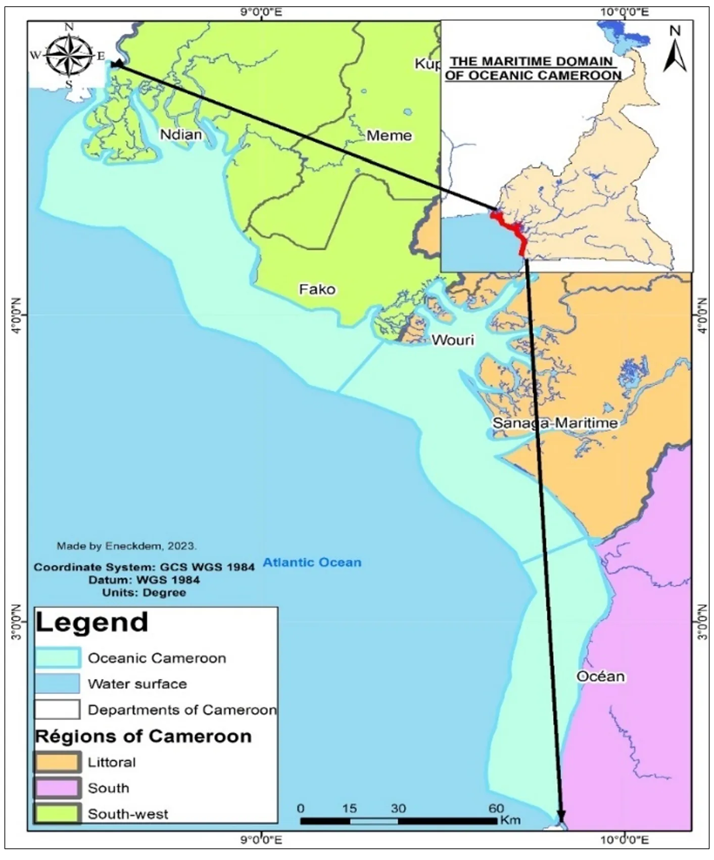
Most of the ocean (71% of the land surface) is outside national jurisdiction. It is the largest renewable energy source in the world, although well known, very little explored and even less exploited. This study explores the marine energy potential of a specific part of the ocean () that falls under the jurisdiction of the State of Cameroon.
Figure 1. Location of the study area: the maritime domain of Cameroon.
According to data from the National Institute of Cartography, taken over by the Ministry of Planning and Regional Development, this study area has an area of 9600 km
2 and represents 2% of the territory. The study exclusively explores the potential of the geographical area of the world ocean located within the legal limits (defined through international agreements) of Cameroonian waters. With a coastline of 590 km, the Cameroonian coastline could, through the exploitation of energy transported by the ocean, contribute to the development of MRE. The MRE potential explored here covers a broad spectrum of sustainable energy sectors, including: hydro turbines, tidal energy, wave energy, marine thermal and osmotic energy. The IPCC defines MRE as: “energy produced by technologies that use seawater as a motive power or that exploit its chemical or thermal potential [in order to] produce electricity, thermal energy or drinking water” [1: 89]. [These can be captured by specific technologies, such as tidal power plants, turbines or tidal turbines] “exploiting ocean tides and currents, heat exchangers based on the transformation of ocean thermal energy and various systems that take advantage of wave energy and salinity gradients” [1: 9].
2.2. Data Collection
This study brings together both oceanographic and spatial data.
2.2.1. Oceanographic Data Collection
In the context of this study, marine data on the Gulf of Guinea are requested. To do this, it is generally considered that
in situ data are more reliable and appropriate [
29]. However, in addition to the inadequacy of data collection units (a characteristic of developing countries such as Cameroon), the World Climate Research Program estimated that most existing sites operated routinely and had uncertainties beyond 12% [
30]. Due to the unavailability of
in situ oceanographic data series for Cameroon, the study relies on models with reassessed reliability using satellite data [
31,
32]. These are reanalyzed satellite data (by comparison with certain
in situ sensors and numerical models covering the global ocean) from specialized research centers, in particular the online oceanographic data management platform of the National Oceanic and Atmospheric Administration (NOAA) and Copernicus Marine Services (CMS). These platforms thus provide information to overcome the scientific barrier of insufficient data. The NOAA interactive platform (https://www.ncei.noaa.gov/, accessed on 27 October 2024) was used for data on marine currents and temperature. These data are LAC (Local Area Coverage) type, with high spatial resolution (1.1 km). The channels of these data are those of the visible (0.58–0.68 μm), allowing the observation of clouds, as well as the three thermal channels (channels 3, 4 and 5) which record the thermal infrared spectrum emitted by surfaces [
33]. The data format is used for calculations. In addition, the CMS interactive platform (https://marine.copernicus.eu/) was used for high-resolution archive data (0.08°), for a depth of 0 to 1000 m (
i.e., 30 ocean layers) on waves, tides and salinity. The data obtained on these platforms is analyzed and extracted from CSV, for our use. These interactive platforms allow all users who wish to stimulate the blue economy and scientific innovation to initiate discussions on sustainable ocean initiatives.
2.2.2. Collection of Spatial Data
The study mobilizes spatially the cartographic funds and databases of the National Institute of Cartography (NIC) of Cameroon. These are the georeferenced databases of the official and most recent geographical units that establish the limits of the continental and maritime domain of Cameroon, in relation to the vast international ocean. These data are those of the 2014 cartographic campaign, obtained in shapefile format (shp) on a removable media. These data were obtained following a request addressed to the institution that made this information available to us.
2.3. Data Processing and Analysis
The objective here is the identification of areas with high potential for EMR in Cameroon, based on the study of indicators of coastal and underwater morphology, coupled with the modeling of wave-induced forcing and many other oceanographic parameters of coastal areas with potential marine energy resources.
2.3.1. Analysis of Current Energy Potential
In terms of current energy, it is similar to exploiting the density of water (nearly 850 times greater than that of air), and production is located where the currents are strongest. Calculating the theoretical power of a marine current turbine depends on several factors, including: current speed, the surface area swept by the blades, and water density. In general, the formula used [
34,
35] to calculate this theoretical power of a current turbine is:
with
P = theoretical power of a hydro turbine (in W),
S = the surface swept by the blades (generally 10 m
2) taken perpendicular to the flow speed,
ρ = the density of the water (kg/m
3) and V the speed of the current (m/s). For the hydro turbine, the density is generally taken as 1025 kg/m
3. Thus, a hydro turbine with a diameter of 10 m could produce 125 kW at the alternator output with a current of 2 m/s and more than 450 kW with a current of 3 m/s, taking into account additional losses.
2.3.2. Analysis of Wave Energy Potential
With regard to wave energy, the evolution of the wave and swell spectrum is described by the balance action equation [
12], which, according to Cartesian coordinates, is:
The first term (on the left side) of the equation describes the local rate of change of the motion density with time. The second and third terms describe the propagation of the motion in geographic space (with propagation velocities
Cx and
Cy in
x and
y space, respectively). The fourth term of the equation represents the change in relative frequency due to variations in depth and currents (with propagation velocity
Cσ in
σ space). The fifth term of the equation describes the refraction induced by depth and current (with propagation velocity
Cθ in
θ space). The term
S [=
S (
σ,
θ)] (on the right side) of the equation is the energy density representing the effects of generation, dissipation, and nonlinear wave-wave interactions.
On this basis, the wave power is estimated by the following formula (although generally applicable when the depth is greater than half the distance between two waves), at the risk of applying, in the opposite case, a more complex formula:
with
P = theoretical power of a wave (kW per linear meter),
H = significant height of the waves (m),
T = peak period of the spectrum or period of the wave (s), that is to say the time which separates the passage of two successive crests [
12].
2.3.3. Analysis of Tidal Energy Potential
As for tidal energy, it is assessed through the prism of potential energy, or pressure energy. It is a reserve energy, proportional to the weight of water stored and its altitude. In absolute value, it corresponds to the work that will be provided by this water in passing from this sea altitude to another.
The potential energy contained in the tidal flow can be calculated by the simplified formula for evaluating the potential in potential energy [
16,
36]:
with
P = Theoretical power of the tidal flow (kW),
ρ = the density of the water (kg/m
3),
V = the volume of water displaced (m
3),
H = the height of the tidal range,
g = the shape coefficient (9.81m/s
2) and 3600 = the conversion factor from kj (kilo Joule) to kWh.
In the absence of input data for a rigorous calculation of the energy potential of this renewable energy sector, the study relies on the morphological analysis of the coast and oceanographic characteristics to discriminate areas of potential for tidal energy [
16].
2.3.4. Analysis of the Potential in Marine Thermal Energy
At the level of Marine Thermal Energy (MTE), solar radiation has a direct effect on the warming of the surface layers of the oceans, but, from a depth of 800 to 1000 m, the temperature is practically constant (around 4 °C at 1000 m depth). The analysis of the MTE potential is based on the principle that the technologies appropriate for this sector require a temperature differential of at least 20 °C between the temperature of the ocean floor and that of the surface [
8]. Due to insufficient data to address this issue, the study relies on literal descriptions and analyses to explore this energy potential on the Cameroonian coast.
2.3.5. Analysis of the Potential in Osmotic Energy
At the level of osmotic energy, it is difficult to assess the potential in the marine part of Cameroon. This is due to the difficulty in having data, both on the salinity of sea water and that of fresh water in the contact zones of these two resources. However, in terms of geographical analysis, the study retains the different contact zones between these two types of resource as potential areas for the development of osmotic energy [
16]. Thus, it is on the basis of this assessment, which falls under the territorial diagnosis that this energy potential is explored on the Cameroonian coast.
2.3.6. Spatial Data Processing and Analysis
Dealing with an eminently spatial question relating to a particular geographical region, the mapping of the various potential MRE sites occupied a primordial place in this study. The spatial analysis was mainly conducted in the Geographic Information System (GIS) software ArcGIS 10.2.2. Data from the NOAA and CMS platforms were processed for different points in Excel 2019 software to evaluate the energy power of each EMR sector. The results obtained were imported into the GIS, where an attribute join was made with spatial data (from the INC), previously processed. Once the attribute join was carried out and the data displayed and visualized in ArcGIS 10.2.2, the information that was once digital took on a spatial character. Subsequently, the study used Kriging interpolation to move from the point implantation of the results to a surface visualization of the discrimination of the EMR potential on the Cameroonian coast. Thus, the processing carried out made it possible to design graphic and cartographic models to better illustrate the argument of the work.
3. Results
The Cameroonian coast offers potential for the development of various MRE sectors, including current energy, tidal energy, wave energy, thermal energy, and osmotic energy.
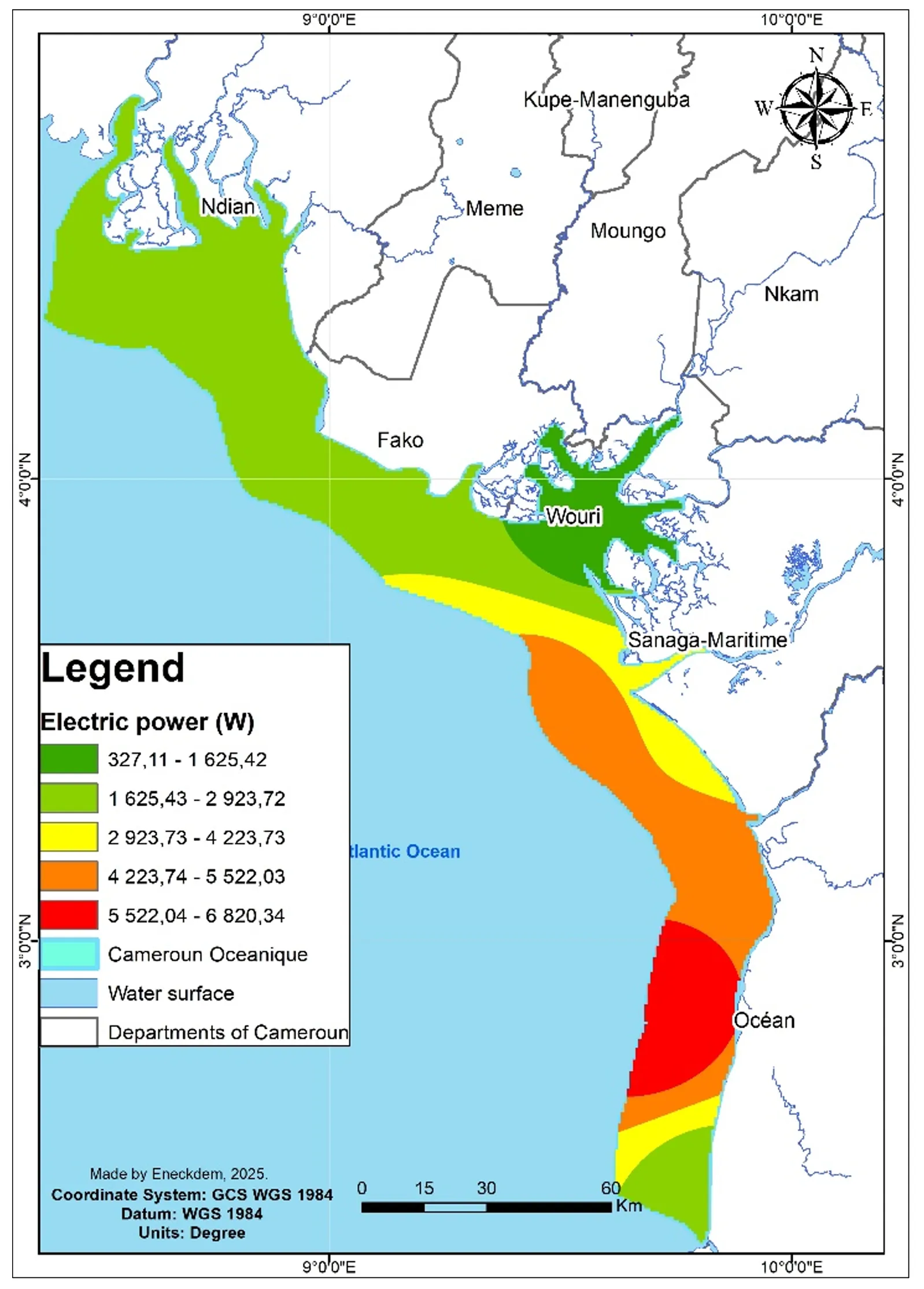
3.1. The Current Energy Potential
The current energy potential, or hydrokinetic energy, is a form of hydroelectric energy that exploits the force of water currents, unlike the usual forms that exploit the power of waterfalls. It uses the kinetic energy of marine currents that will operate hydrokinetic turbines, generally underwater, but also with a floating part. The energy content of the hydrokinetic resource at a given time “t” depends on the speed of the current and the height of the water column. With marine currents whose speed varies globally between 0.4 and 1.2 m/s off the coastal zone, Cameroon has a significant potential in hydrokinetic energy, the importance of which varies from one area to another, depending on the specific dynamics of the geographical area considered (
)
Figure 2. Spatialization of hydroelectric energy potential.
The analysis of the data and calculations carried out shows that the average theoretical power of current energy on the Cameroonian coast is approximately 3802.75 W. This potential is essentially variable depending on the marine area considered. Indeed, it is much greater offshore (approximately 6 kW) than on the coasts (approximately 1 kW) and even less in the Wouri estuary (approximately 328 W). Also, the spatial discrimination of this potential in the Cameroonian marine area reveals the open sea of the Kribian coast as the most suitable area for the development of this energy sector, with peaks of production potential of up to 5 kW.
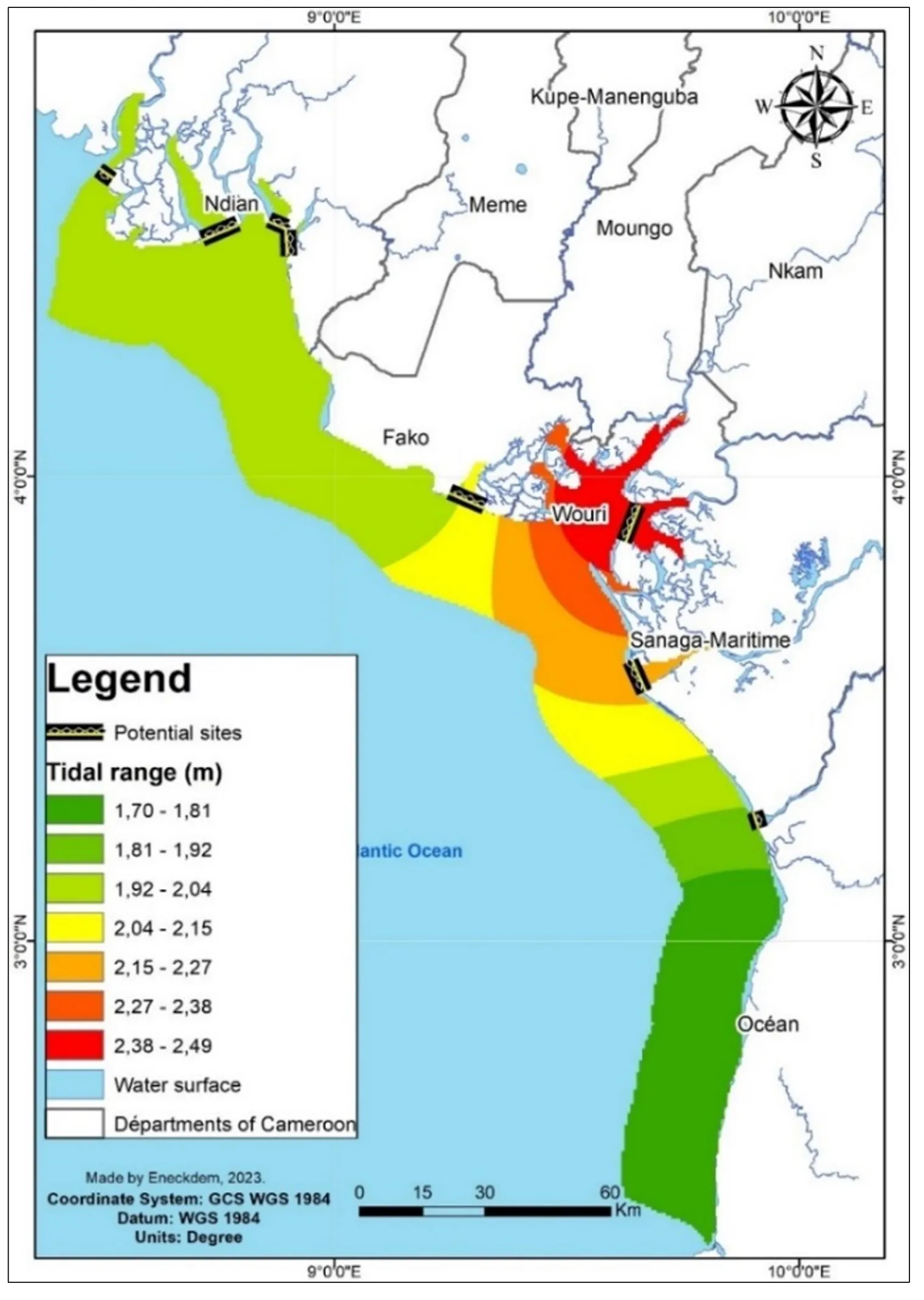
3.2. Tidal Energy Potential
Tidal energy is the product of the relative movements of the Earth, the Sun and the Moon, which combine to create a cycle of gravitational changes in the ocean mass. As a result, variations in sea height are observed in Cameroon and of different importance depending on the specific dynamics of the geographical space considered, making it possible to define areas potentially favorable to this energy sector ().
Figure 3. Spatialization of potential tidal energy development sites.
This mapping is mainly based on the morphological criteria of coastal areas predisposed to the construction of tidal power plants. From these variations in sea height during its cycles, potential energy is then created. The variations also form tidal currents, which have kinetic energy. The most advanced technology in this field remains the capture of water in a dam built in a basin or estuary with high potential, which releases the water by means of gravitational force. Based on the height of the tide, the flow and reflux of the water turn the turbine at the entrance of the dam to produce electricity. Thus, knowledge of the variations in tide level makes it possible to estimate the energy performance to be expected from a tidal power plant projected on a given site. The tidal range is essentially variable depending on the geographical area. Thus, the Wouri estuary appears to be the most favorable area with the largest tidal range (about 2.3 m), while it is the least important on the Kribian coast (about 1.5 m). However, given the significant importance of the river port of Douala (at the bottom of the Wouri estuary) in the Cameroonian economy, it is difficult to envisage the construction of a dam that would obstruct ship traffic at the entrance to the estuary. Consequently, a tidal power plant would only be possible on the southwest arm of this estuary (in the Manoka, Epassi, Petit-Dibamba sector).
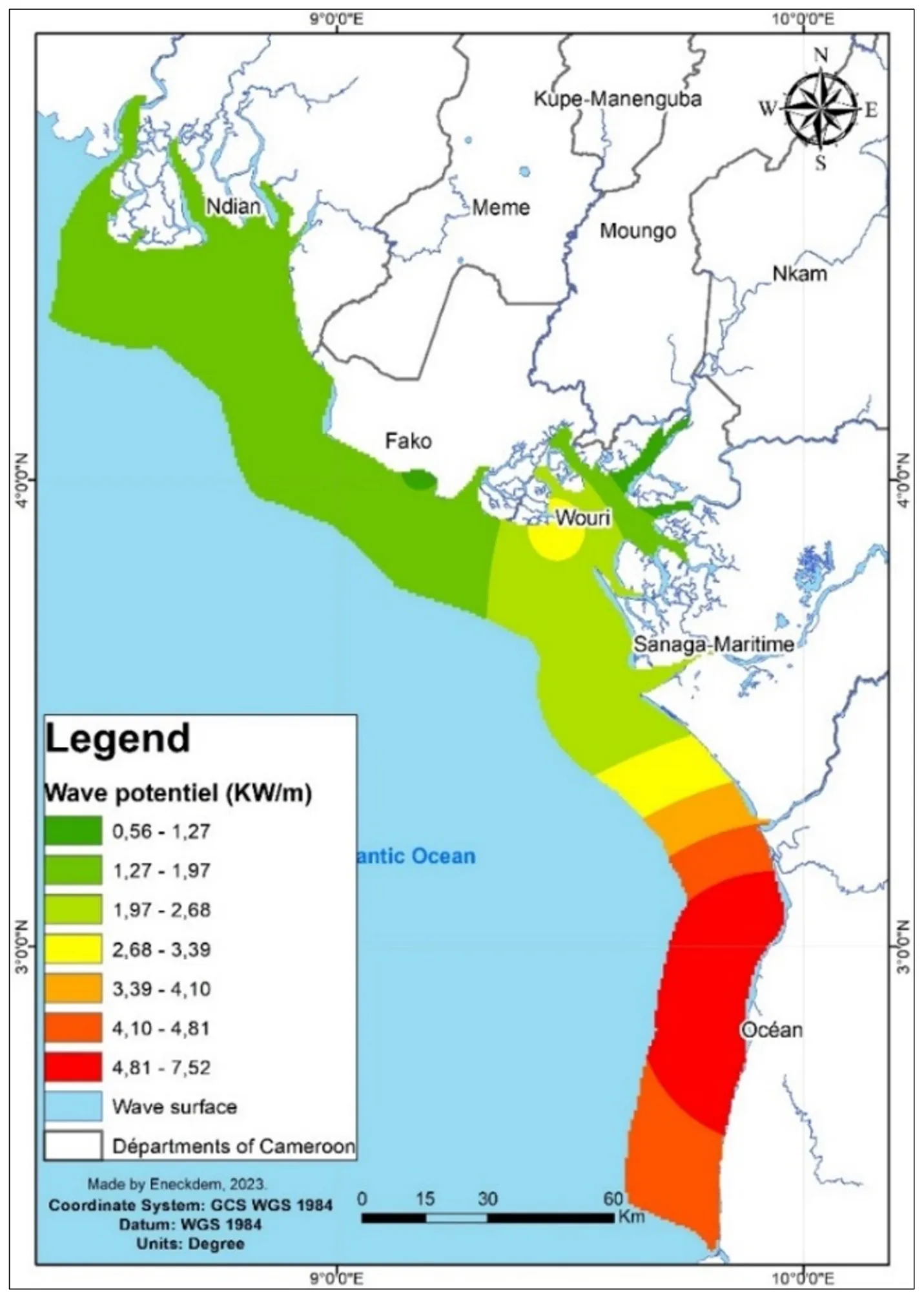
3.3. Wave Energy Potential
The energy of waves and swell is determined by their height, which is essentially dependent on several factors including: wind speed, open water range, water depth and seabed topography. Waves were considered for a long time in Cameroon, as elsewhere, to be harmful because of their erosive effects and the damage they can cause on the coast. However, they carry renewable energy that can be exploited, in particular for the sustainable development of coastal and littoral areas. They have, in fact, enormous potential for the generation of “clean” electrical energy, because the kinetic energy transferred to the wave can be captured to produce electricity. This can be done either by observing the breaking of waves near the coast or by using the variation in height during the passage of the swell. With a coastal linear of 590 km, the Cameroonian coastline could, through the exploitation of energy transported by waves and frequent swells, contribute to the development of this energy sector, whose potential decreases from the coast of Kribi to Bamusso Bay in the Southwest Region. Analysis of the data and calculations carried out show that the average production potential is approximately 3.37 kW/m in Cameroon. This potential varies significantly from one area to another in the Cameroonian marine space ().
Figure 4. Spatialization of wave energy potential.
The production potential is much greater on the Kribi coast (between 4 and 7 kW/m), where the specific wave height generally reaches 0.9 to 1 m. However, there are also areas of low potential, such as the Wouri estuary, where this energy option would be very unlikely.
3.4. The Potential in Marine Thermal Energy
Marine Thermal Energy (MTE) results globally from the heat exchange between the heat transmitted by the sun to the surface waters of the oceans and seas and the cold waters of the depths. It exploits the temperature differential between surface waters (warmer) and deep waters (colder).
A country in the Intertropical Zone (receiving maximum solar irradiation), Cameroon’s ocean surface waters are among the warmest in the world. NOAA data shows that over the period 1981 to 2005, the average sea surface temperature was approximately 28.1 °C on the Kribi coast and 29.4 °C on the Limbe coast. This constitutes a major asset for the development of the MTE potential. This development will involve plants composed of an evaporator-turbine-condenser assembly, pipes and feed pumps to recover and transport cold water from the depths and warm water from the surface.
3.5. Osmotic Energy Potential
Osmotic energy comes from the physicochemical potential produced by the salinity differential between seawater and freshwater from the continent at the level of estuaries. Thus, when two masses of water with different salt concentrations are in contact, the fresh water molecules naturally tend to move from the less condensed compartment to the more condensed one, to re-establish the concentration balance: this is the phenomenon of osmotic pressure, the materialization of which involves energy that can be recovered. The principle is simple and well-known, and requires sophisticated membranes that can be used on a large scale in estuaries. Sea salinity along the Cameroonian coast is generally low (compared to the open ocean or the Mediterranean), although it can vary considerably depending on the area. This is more pronounced during the rainy season. CMS data show that an average surface salinity of 0.4% is recorded in the Wouri estuary.
4. Discussion
From the outset, it should be noted at the methodological level that for an assessment of energy potential,
in situ data are generally considered to be more reliable and appropriate [
13]. However, in several developing countries such as Cameroon, the development of the energy potential of territories generally comes up against the insufficient availability (in quality and consistency), or even the non-existence of data from ground measuring stations [
28]. To overcome this difficulty, studies faced with such a problem of
in situ data generally use models with reassessed reliability based on satellite data [
31,
32]. Indeed, since the 1980s, satellites have become one of the preferred instruments of geosciences [
29]. To improve the reliability of satellite products, scientists compare them with existing ground data, using correction and interpolation matrices [
37]. Thus, satellite data have proven to be precise and reliable in meteorology and oceanography, particularly in regions where surface measurements are rare or non-existent [
3]. Furthermore, by comparing these satellite data to ground measurements at several sites, the estimated error is less than 5% [
25]. However, it would be interesting for the prospective if the potential were rigorously reassessed using
in situ data to compare the results [
30]. Nevertheless, for a feasibility study, satellite data based on models with reassessed reliability are an opportunity to initiate reflections that could guide decision-making [
17].
At the data processing level, it should be noted that the formula for calculating the production potential of an offshore tidal turbine can generally be improved by integrating a power Coefficient (pC) into the calculation parameters in order to take into account the turbine efficiency (although still low currently) [
36,
38]. Thus, the theoretical power of a tidal turbine would be estimated by multiplying the results obtained by pC, representing the turbines efficiency in converting fluid energy into mechanical energy. This coefficient varies (generally between 0.25 and 0.45) depending on the turbine design and operating conditions, with a theoretical maximum of 0.59 according to the Betz limit. Given that turbine efficiency does not currently reach the Betz limit, some studies retain the value of 0.45 [
39]. However, by integrating this constant, the results obtained in the study will be revised downwards. In terms of wave energy, the study does not differentiate between offshore, nearshore and coastal wave energy potential [
12]. The work is intended to be global and exploratory across the entire energy sector. With regard to tidal energy, it should be noted that technologies for valorization through the construction of dams, such as the Rance plant (in France), generate significant impacts on the environment compared to new technologies focused on tidal currents. These dams greatly influence the nature of fish and other fish species migrations in areas near the dams [
1]. Also, although the Wouri Estuary is considered a preferred area for the development of this sector, its economic attributes (access zone to the port of Douala: economic lung of the country) rather compromise this dam option, which would close the channel. However, due to the environmental impact of dam-type installations, new, more modern techniques with a much lower impact are attempting, using dam-free turbines, to capture the tidal current that enters and leaves a basin or estuary with high potential [
32]. As for the Marine Thermal Energy (MTE) sector, it should be noted that it is generally very expensive, but significant progress has been made over the years [
5]. As for osmotic energy, this sector is still immature, expensive and environmentally problematic. Progress in this sector remains insignificant and deserves to be emphasized [
11]. From the point of view of spatialization of results, ArcGIS Pro software would present several advantages for marine analysis, in particular its 3D capabilities for seabed modeling, its complementarity with other GIS tools and programming platforms for more in-depth analysis [
5]. Furthermore, the use of NetCDF data with ArcGIS Pro would be more appropriate for marine analysis than converting them to CSV as in this study.
Overall, the results of this study do not deviate too much from the mapping of MRE potential on a global scale. Indeed, as noted by [
16], the wave energy potential is generally modest in the Gulf of Guinea. Potentials are recorded there around 10 kW/m, well below the 120 kW/m recorded in North America or the South Pole. Furthermore, it should be noted that with regard to the hydro turbine, failure to take into account a power coefficient can lead to an overestimation of the producible [
16,
35,
39]. Indeed, in practice, the widening of the fluid flow in the vicinity of the blades of the hydro turbine causes its current speed to drop. Thus, the harvested power is often limited to 60% of the calculated theoretical power [
34]. From this, the machine losses linked to friction and the conversion of mechanical energy into electrical energy must be deducted, which leads to an overall efficiency of 40 to 50% [
39]. It should be noted with [
39] that, depending on the nature of the MRE technology to be developed and the characteristics of the study site, the technical criteria used in this study are not entirely suitable. Indeed, the methods and calculations used have certain limitations that could be minimized by using numerical calculation models such as TOMAWAC or SWASH, which are appropriate for carrying out potential transfer calculations [
17]. The approach adopted in this study, which made it possible to estimate and spatialize the MRE potential from oceanographic and geographical data, may be limited in the opinion of several specialists [
6,
10,
13]. Indeed, [
17] believes that such an analysis must be based on a significant number of basic data beyond the parameters retained in this study, including oceanographic, environmental, human, and even regulatory constraints. Thus, to optimize such an analysis, it would be beneficial to juxtapose these different data and constraints to achieve better zoning of potential MRE development areas [
16]. The technical and economic analysis of the MRE sectors reveals that, apart from offshore wind, the other sources are still in the development or demonstration phases and require investments to achieve competitive production costs. Indeed, the comparative examination of the different MRE sectors (
) reveals significant technological and economic obstacles in the deployment of these renewable energies.
.
Technical and economic overview of the Marine Renewable Energy sectors [38].
Energy
Feature Sources |
Tidal Power |
Hydro Turbine |
Wave Power |
Thermal |
Osmotic |
| Estimated global resource (TWh/year) |
300 |
800 |
80,000 |
10,000 |
2000 |
| Stage of development |
Industrial for classic tidal power, but early for offshore lagoons |
Advanced, pilot and pre-commercial project stages |
Development and demonstration phase |
Very early, technology still in the demonstration phase |
Very early, technology in experimental phase: a few pilot projects, low capacity |
| Production costs (estimated) |
Between 50 and 150 €/MWh |
Between 200 and 300 €/MWh |
Between 200 and 500 €/MWh |
Between 150 and 300 €/MWh |
Between 200 and 400 €/MWh |
| Benefits |
Proven technology |
Reduced space required |
No foundations required and easy maintenance |
Continuous production and predictability |
Continuous production and perfect predictability |
| Disadvantages |
-Intermittent operation
-Major environmental upheavals
-High initial cost, due to the massive infrastructure required (dams)
|
-Intermittent operation
-Complicated maintenance
-Restricted sites
-Can prevent maritime activities
-High production costs
|
-Intermittent operation
-Can prevent maritime activities
-High production costs
|
-High initial investment
-Technical complexity
-High production costs
-Low efficiency
|
-High initial investment
-Low efficiency
-Currently very high production costs due to low technological maturity
-Cost of cleaning semi-permeable membranes
|
In a developing country like Cameroon, where the technological take-off is still weak, various technological obstacles can be identified in the start-up of the MRE sectors [
7]. These are barriers related to the manufacture of equipment (the extreme environment represented by the ocean), electrical design (electrical connection systems in the marine environment), installation in the marine environment (installation and assembly of functional assemblies), energy converters (dimensioning of energy storage, behavior of electrical machines and components at sea), electrical connection (distance to the high-voltage network for high-power parks, technological connection solutions, reduction of electrical losses, security of the electrical network and systems), operation and maintenance, etc. [
6,
7,
10]. Furthermore, from an economic point of view, MRE technologies are still too expensive to offer a viable, sustainable energy alternative in the near future to communities and governments [
7,
16]. Also, potentially very favorable sites are limited for tidal and hydroelectric energies. This is why wave, and somewhat thermal and osmotic technologies may seem suitable for the country due to the low availability of strong currents or large tidal areas. Furthermore, the results of the study only modestly call upon technical and economic analyses to account for the potential of MRE in Cameroon. Unlike [
12,
16], the analysis of the energy source is done by only mentioning the theoretical power, including the technological devices for energy recovery and the planned land connection (voltage drops, transformer losses, annual availability of the electricity network, maximum connection power of a park). In this logic, it is objectively possible to define the scenarios for the deployment of MRE at different time scales on Cameroonian territory only on the basis of the previous elements to be provided in the context of other investigations [
12], which would have the effect, according to some specialists, of overestimating the contribution of the technical aspect and of minimizing the economic analyses which are nevertheless cardinal in any societal project [
7,
38].
In addition to initiatives focused on promoting renewable energy, there is an increasing development of demand-driven mitigation measures and changes in energy behavior [
2]. While these measures are crucial in trajectories that aim for the 1.5 °C objective, they can hinder the achievement of other societal objectives, such as the development of renewable energy potential (according to the high confidence scenario) [
2]. Indeed, the significant uncertainties surrounding renewable energy can be a handicap to their development in the same way as other renewable energy technologies [
1,
15]. The renewable energy market is still at an early stage, existing electricity networks are not always suitable for transporting marine energy, and their development can take several years [
8,
38]. In addition to delays in technology transfer to developing countries, MRE technologies are still too expensive and quite complex [
40]. The valorization of MRE remains very limited in developing countries, due to the lack of financial, material and technological resources [
11,
20,
40]. This is justified, among other things, by the fact that developed countries have not kept their financial and technological commitments to developing countries [
25]. As a result, the objectives of limiting global warming to 1.5 °C or even 2 °C remain problematic due to the low participation of developing countries in the global effort.
5. Conclusions
The study aimed to make a contribution, however modest, to assessing the potential for MRE electricity production on the Cameroonian coast in the Gulf of Guinea. Drawing on the geography of renewable energy, the aim was, on the one hand, to identify potential MRE conversion technologies and, on the other, to identify areas potentially favorable to each of the sectors.
The MRE potential was assessed using a methodology based on the territorial diagnosis approach. This approach draws on scientific literature, oceanographic data, energy resource calculations, and mapping using GIS data and tools (notably ArcGIS 10.2.2). Particular emphasis was placed on identifying geographic determinants likely to account for the MRE potential of the oceanic territory under Cameroon’s jurisdiction.
Based on the analyses carried out, we can see that the Cameroonian coastline is full of significant potential for the development of MRE. Indeed, with a potential of around 6 kW off the Cameroonian coast and around 1 kW on the coast, current turbines are a capitalizable opportunity. Regarding wave energy, the producible potential is much greater on the Kribi coast (between 4 and 7 kW/m). Also, significant potential in terms of tidal energy can be mobilized at the Wouri Estuary, as well as other sectors such as MTE and osmotic energy. Despite the existing potential, MRE technologies (which have not yet proven themselves technically and economically) are not as advanced as those of other renewable energy sectors.
Thus, as a perspective, the work would benefit from taking into account technical and economic analyses based on in situ data to provide a better estimate of the energy potential and objectively define the scenarios for the deployment of MREs at different time scales on the Cameroonian coast in particular and in the Gulf of Guinea in general.
Author Contributions
Conceptualization, V.E.T. and M.T.; Methodology, V.E.T.; Investigation, V.E.T.; Writing—Original; Draft Preparation, V.E.T.; Writing—Review & Editing, V.E.T.; Supervision, M.T.
Ethics Statement
Not applicable.
Informed Consent Statement
Not applicable.
Data Availability Statement
The datasets generated during and/or analysed during the current study are available from the corresponding author on request.
Funding
This research received no external funding.
Declaration of Competing Interest
The authors declare that they have no known competing financial interests or personal relationships that could have appeared to influence the work reported in this paper.
References
-
1.
GIEC. Sources d’énergie renouvelable et atténuation du changement climatique, Rapport spécial du Groupe d’Experts Intergouvernemental sur l’Evolution du Climat, Résumé à l’intention des décideurs et résumé technique, Rapport du Groupe de travail III du GIEC, 2011, 242. Available online: https://www.ipcc.ch/site/assets/uploads/2018/03/srren_report_fr-1.pdf (accessed on 27 October 2024).
-
2.
GIEC. Réchauffement planétaire de 1,5 °C, Rapport spécial du GIEC sur les conséquences d’un réchauffement planétaire de 1,5 °C par rapport aux niveaux préindustriels et les trajectoires associées d’émissions mondiales de gaz à effet de serre dans le contexte du renforcement de la parade mondiale au changement climatique, du développement durable et de la lutte contre la pauvreté, Groupe de travail I, II et III du GIEC, OMM, PNUE, 2019, 110. Available online: https://www.ipcc.ch/site/assets/uploads/sites/2/2019/09/SR15_Summary_Volume_french.pdf (accessed on 27 October 2024)
-
3.
Beny F, Canas S, Chavanne M, Deutsch D, Persoz L, Tuel A. Available online: https://theshiftproject.org/app/uploads/2025/05/RapportSYRAR6v1.pdf (accessed on 12 October 2024).
-
4.
Lian J, Cui L, Fu Q. Offshore Renewable Energy Advance.
Mar. Energy Res. 2024,
1, 10006. doi:10.70322/mer.2024.10006.
[Google Scholar]
-
5.
GIEC. Réchauffement planétaire de 1,5°C, Rapport spécial du Groupe d’Experts Intergouvernemental sur l’Evolution du Climat, Résumé à l’intention des décideurs, 2018, 110. Available online: http://www.ipcc.ch/site/assets/uploads/sites/2/2019/09/SR15SummaryVolumefrench.pdf (accessed on 27 October 2024).
-
6.
Rusu EVC. Harvesting Offshore Renewable Energy an Important Challenge for the European Coastal Environment.
Sustain. Mar. Struct. 2023,
5, 11–13.
[Google Scholar]
-
7.
Santhakumar S, Meerman H, Faaij A. Future costs of key emerging offshore renewable energy technologies.
Renew. Energy 2024,
222, 119875.
[Google Scholar]
-
8.
IFDD. Les énergies marines, In Programme International de Soutien à la Maîtrise de l’Énergie (PRISME), les énergies renouvelables, Fiche nº 15, 2018, 8. Available online: https://www.ifdd.francophonie.org/wp-content/uploads/2021/09/736_IFDD_FichePrisme_No15_Les_energies_marines-4.pdf (accessed on 27 October 2024).
-
9.
Oiry A. Conflits et stratégies d’acceptabilité sociale autour des énergies marines renouvelables sur le littoral français.
VertigO 2015,
15, 3. doi:10.4000/vertigo.16724.
[Google Scholar]
-
10.
Farrok O, Ahmed K, Tahlil AD, Farah MM, Kiran MR, Islan MR. Electrical power generation from the oceanic wave for sustainable advancement in renewable energy technologies.
Sustainability 2020,
12, 2178.
[Google Scholar]
-
11.
Esoh E, Nkeng EG. Transition vers les énergies renouvelables au Cameroun: Quelques idées innovantes pour les villes; Editions L’Harmattan: Yaoundé, Cameroon, 2022; p. 216.
-
12.
Schneider F. Les énergies marines renouvelables : Approche juridique en droit international européen et comparé, Institut du droit économique de la mer; Editions A. Pedone: Paris, France, 2015; p. 594.
-
13.
Hemdane Y, Bouhmadouche M, Atroune F. Identification des zones côtières à fort potentiel en énergie marine renouvelable (vagues/houles) à travers l’étude de la morphologie côtière et sous-marine et hydrodynamique.
Rev. Des. Energ. Renouvelables 2016,
19, 543–552.
[Google Scholar]
-
14.
Zhang B, Peng W, Li Y. State of the Art in Wave Energy Conversion Technologies in China.
Mar. Energy Res. 2025,
2, 10004 doi:10.70322/mer.2025.10004.
[Google Scholar]
-
15.
Cloarec M. Estimation de la bathymétrie par Observation de la Terre pour les énergies marines renouvelables. Thèse de Doctorat, MINES ParisTech, Université de recherche Paris Sciences et Lettres, Paris, France, 2018.
-
16.
Musial W, Tegen S, Driscoll R, Spitsen P, Roberts O, Kilcher L, et al. Survey and Assessment of the Ocean Renewable Energy Resources in the US Gulf of Mexico; Bureau of Ocean Energy Management, National Renewable Energy Laboratory: New Orleans, LA, USA, 2020; p. 82.
-
17.
Ledoux S, Chotard D, Mazeiraud V, Garcia N, Saillard T, Mensencal Y, Mouslim H. Méthodes de calculs des potentiels et productibles associés aux énergies marines: Études de cas en Manche-Atlantique.
La Houille Blanche 2015,
3, 18–25.
[Google Scholar]
-
18.
Nkue V, Njomo D. Analyse du système énergétique camerounais dans une perspective de développement soutenable.
Rev. De l’Energ. 2009,
588, 102–116.
[Google Scholar]
-
19.
Banque Mondial. Cameroun: Plan d’Action National Energie pour la Réduction de la Pauvreté (PANERP), Energy Sector Management Assistance Program (ESMAP), Technical Paper 117/07, Washington, Etats Unis d’Amérique, 2007, 178. Available online: http://documents1.worldbank.org/curated/en/943121468228545709/pdf/407590CM1Energ1ical1Report01PUBLIC1.pdf (accessed on 13 November 2024).
-
20.
Global Village Cameroon. Etat des lieux du cadre règlementaire du secteur des énergies renouvelables au Cameroun, Rapport d’analyse, Yaoundé, 2012, 88. Available online: http://ekladata.com/e9IeYOLwp0TSo7QqTR6pXVuZ7xk/Rapport-etat-des-lieux-cadre-juridique-des-energies-renouvelables-au-CamerounGVC-2012.pdf (accessed on 15 November 2024).
-
21.
Fondja YD. Energie, économie et environnement: Contradiction ou co-développement?: Le cas du Cameroun, Col. Etudes Africaines; Editions l’Harmattan: Paris, France, 2012; p. 295.
-
22.
Tchatat G. Cameroun: Contribution à la préparation du rapport national pour la formulation du livre blanc régional sur l’accès universel aux services énergétiques intégrant le développement des énergies renouvelables et de l’efficacité énergétique. Rapport Final, PNUD, Yaoundé, 2014, 245. Available online: https://www.seforall.org/sites/default/files/Cameroon_RAGA_FR_Released.pdf (accessed on 21 October 2024).
-
23.
MINEE. Cameroon Rural Electrification Master Plan (PDER). Available online: https://www.ied-sa.fr/en/ied-consult/energy-transition-and-planning/update-of-the-rural-electrification-master-plan-pder/ (accessed on 12 October 2024).
-
24.
Mbiake R, Atontsa C, Bell JM. Les énergies renouvelables dans le champ politique et légal de l’énergie au Cameroun, Chapitre 30, Section 9: Mining and energy. In Environmental Law and Policy in Cameroon–Towards Making Africa the Tree of Life, 1st ed.; Ruppel OC, Kam Yogo ED, Eds.; Konrad-Adenauer-Stiftung: Yaoundé, Cameroun, 2018; pp. 637–665.
-
25.
Nguesseu A, Thang D, Ndjeudja R. Options politico-juridiques pour un envol durable des énergies renouvelables au Cameroun; Friedrich Ebert Stiftung: Yaoundé, Cameroun, 2019; p. 74.
-
26.
ADEID. Les énergies renouvelables comme solution prioritaire au déficit énergétique dans les zones rurales du Cameroun, 2021. Available online: http://climatdeveloppement.org/wp-content/uploads/2014/08/Argumentaire-Cameroun-FINAL.pdf5 (accessed on 2 November 2025).
-
27.
Onguéné R. Modélisation multi-échelle de la circulation océanique en Afrique centrale, de la plaine abyssale à l’estuaire du Cameroun. Océanographie, Thèse de Doctorat, Université Paul Sabatier–Toulouse III, Toulouse, France, 2015.
-
28.
Eneckdem TV, Feumba RA, Tsomo O, Bogning JR. Contribution of Cartography to the Optimization of the Evaluation of Wind Energy Potential in the Republic of Cameroon: Case of Bitchoua Highlands.
J. Geogr. Environ. Earth Sci. Int. 2021,
25, 53–66.
[Google Scholar]
-
29.
Tsalefac M, Ngoufo R. Les satellites météorologiques et la redécouverte des climats de la planète : L’expérience de l’estimation des pluies par satellites au Cameroun par l’équipe EREDCA.
Hist. Géographes 2002,
379, 275–281.
[Google Scholar]
-
30.
Stackhouse P, Chandler W, Zhang T, Westberg D, Barnett A, Hoell J. Power Release 8 (with GIS Applications) Methodology (Data Parameters, Sources, & Validation), Data Version 8.0.1; NASA Applied Science Program: Washington, DC, USA, 2018; p. 89.
-
31.
Kaplanis S. New methodologies to estimate the hourly global solar radiation: Comparison with existing models.
Renew. Energy 2006,
31, 781–790.
[Google Scholar]
-
32.
Madkour M, Hamed A. Comparative study on different models for estimation of solar radiation.
Renew. Energy 2006,
31, 361–382.
[Google Scholar]
-
33.
Egan KE, Le JT, Murphy JWA, Netburn AN, Bohan M, Copeland A, et al. Exploration Variables Identified By NOAA Ocean Exploration NOAA Ocean Exploration Program. MD. NOAA technical memorandum OAR OER.
Silver Spring 2021,
004. 126. doi:10.25923/m37w-8b55.
[Google Scholar]
-
34.
Maître T. Les hydroliennes, Sources renouvelables. Available online: https://www.encyclopedie-energie.org/wp-content/uploads/2018/09/art068_Maitre-Thierry_hydroliennes.pdf (accessed on 2 June 2025).
-
35.
IESF. La mécanique au service de la transition énergétique. Available online: https://www.iesf.fr/offres/file_inline_src/752/752_pj_220719_131436.pdf (accessed on 2 June 2025).
-
36.
Hydrelect. Estimation du potentiel énergétique marin. Available online: http://www.hydrelect.info/index.php?lng=fr (accessed on 8 October 2024).
-
37.
Pinker R, Laszlo I. Modeling Surface Solar Irradiance for Satellite Application on a Global Scale.
J. Appl. Meteorol. 1992,
31, 194–211.
[Google Scholar]
-
38.
CDE. Énergies marines, Fiches pédagogiques. Available online: https://www.connaissancedesenergies.org/fiche-pedagogique/energies-marines (accessed on 27 October 2024).
-
39.
Normandajc LP, Bréard J, Mouazé D. Theoretical calculation of the power of hydro turbine or tidal turbine. Available online: https://hal.science/hal-01982516v6 (accessed on 1 June 2025).
-
40.
Lalancette S, Le FP, Le GB. Les énergies marines renouvelables répondent-elles au modèle d’économie de la fonctionnalité?
VertigO 2019,
19, 27.
[Google Scholar]
 Mesmin Tchindjang
1,2
Mesmin Tchindjang
1,2