
Towards Enhanced Valenciaport Security: Integration of Advanced Unmanned Vehicle Systems with 5G SA
Towards Enhanced Valenciaport Security: Integration of Advanced Unmanned Vehicle Systems with 5G SA
Rafael Company
1,*
 José Miguel Higón
1
Marina Gabarda
1
Ángel Laguna
1
Francisco Pérez
2
Ángel García
2
Daniel Severinsen
3
Simone Contorno
3
Received: 15 April 2026 Revised: 14 July 2026 Accepted: 28 August 2026 Published: 11 September 2026

© 2026 The authors. This is an open access article under the Creative Commons Attribution 4.0 International License (https://creativecommons.org/licenses/by/4.0/).
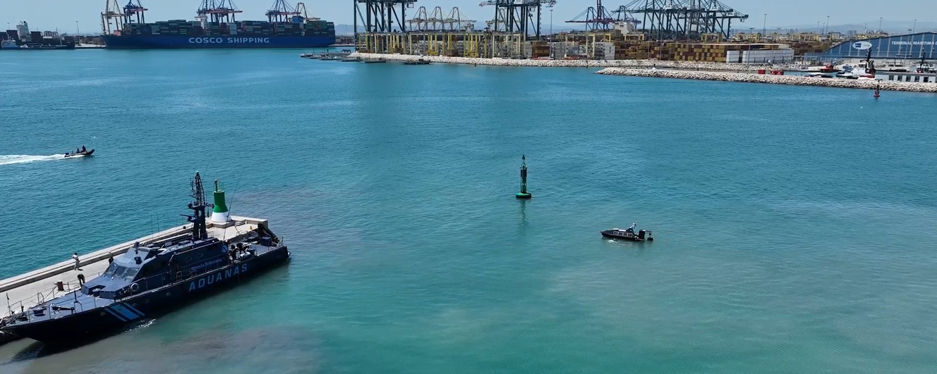
Graphical Abstract
1. Introduction
Underwater security is critical for protecting port operations, and any interruptions in that security can create major challenges for active and ongoing port operations. The Port of Valencia, one of the busiest and most technologically advanced ports in Europe, faces daily challenges related to vessel traffic management, infrastructure maintenance, and the prevention of unauthorized underwater activities. Traditional monitoring solutions, such as diver inspections or fixed sensors, often provide limited coverage and slow responses in dynamic maritime environments.
To address these challenges, recent advances in autonomous systems and smart port technologies have introduced innovative solutions that integrate multiple sensing and surveillance platforms. Using Unmanned Underwater Vehicles (UUVs), Unmanned Surface Vehicles (USVs), and Unmanned Aerial Vehicles (UAVs), ports can implement a coordinated, multi-domain situational awareness framework. Supported by 5G communications and AI-based detection algorithms, these systems enable continuous monitoring, more rapid identification of anomalies, and improved decision-making at the port command and control centre.
In this context, the Lemvos autonomous platform represents a significant advancement in port security operations. Its integration with existing infrastructure and sensor networks provides a scalable and adaptive approach to maritime surveillance. Autonomous operation reduces human exposure to risk while increasing efficiency in inspection and monitoring tasks. The following sections present experimental results and operational tests conducted at the Port of Valencia, including an analysis of performance metrics and detection capabilities.
The main contributions of this work can be summarized as follows:
-
-
Design, integration, and field deployment of a 5G-enabled unmanned surface vehicle (LEMVOS LM450) combining optical and sonar sensing for port-security monitoring.
-
-
Experimental validation of dedicated 5G Standalone (SA) connectivity for teleoperated USV operation in a real, operational port environment (Port of Valencia).
-
-
Controlled experimental assessment of sonar-based detection of submerged objects, including a dedicated narcotics-tube detection trial and a comparison of achieved versus target sonar KPIs.
The remainder of this paper is organized as follows: Section 2 reviews the state of the art in autonomous port-security platforms, underwater acoustic detection and 5G infrastructure for maritime applications; Section 3 describes the Port of Valencia test site; Section 4 details the USV system architecture, hardware, software and sensor integration; Section 5 presents the experimental tests and results obtained at the Port of Valencia; Section 6 outlines planned future developments toward greater autonomy; and Section 7 concludes the paper.
2. State-of-the-Art
Technology is advancing rapidly, and smugglers are developing new ways to threaten ports around the world. Maritime smuggling is the general term for a type of crime in which drugs, people, and illegal goods are brought into countries by sea due to the amount of sea cargo being transported globally [1]. A notable example is the series of incidents reported along the Galician coast involving narco-submarines transporting tons of illegal substances [2]. The increase in drug smuggling from one port to another has put added strain on the capabilities of port enforcement agencies to provide improved detection systems to prevent this type of criminal activity [3]. There are a number of intelligent data-driven techniques that have been or will be developed to identify potential smugglers and to identify abnormal behaviors of maritime vessels [4]; this has been evidenced by the recognition from the U.S. Coast Guard and law enforcement that smugglers are using sophisticated concealment and evasion techniques, necessitating proactive and technologically advanced countermeasures to be developed [5]. As a result, the detection and prevention of such advanced threats will require future technological enhancements to the existing port safety and security infrastructure. There are many new technologies being used to improve maritime surveillance and port security/protection; see Table 1 and Table 2 for examples of advanced technology being used to improve maritime surveillance and port security.
Table 1. Robotic Systems for Port Surveillance and Security.
|
Type |
Definition |
|---|---|
|
USV [6] |
Small or medium-sized autonomous vessels that navigate the water surface using GPS and onboard sensors. They can be remotely controlled or operate independently along predefined routes. |
|
ROV (Remotely Operated Vehicle) [7] |
Underwater robots tethered to a control station via cable, allowing precise maneuvering and continuous video transmission. They can operate at greater depths than divers and carry tools or manipulators. |
|
AUV (Autonomous Underwater Vehicle) [8] |
Fully autonomous underwater robots capable of long-duration missions without real-time human control. Equipped with sonar, cameras, and navigation systems to map and inspect underwater environments. |
|
UAV [9] |
Aerial platforms equipped with optical, infrared, or multispectral cameras, capable of real-time data transmission and autonomous flight patterns. They can cover large areas quickly and operate in locations that are difficult or dangerous for humans. |
Table 2. Sensor and Detection Technologies Used in Port Security.
|
Type |
Definition |
|---|---|
|
FLS (Forward Looking Sonar) [7] |
A sonar system that sends sound waves forward to create real-time images of the underwater environment ahead of a vessel, helping to detect and avoid obstacles. |
|
SSS (Side-Scan Sonar) |
A sonar device that emits sound pulses to both sides of a vessel to produce high-resolution images of the seabed and underwater objects. |
|
Optical sensors that capture visual, infrared, or thermal images. They are used for continuous observation and documentation of port areas. |
|
|
Hydrophone |
An underwater acoustic sensor that detects, records, and analyses sounds in the water, such as those produced by marine life or machinery. |
|
AIS (Automatic Identification System) |
An electronic system that automatically transmits and receives data about a vessel’s identity, position, speed, and route to improve navigation and tracking. |
|
LIDAR (Light Detection and Ranging) |
A remote sensing technology that uses laser light to measure distances and generate precise 3D models or maps of surfaces and surroundings. |
All these systems and sensors can be integrated and processed using advanced data fusion and AI-based analytics to provide comprehensive situational awareness.
2.1. Operational Deployment in Real-World Scenarios
An illustrative example of the application of these technologies in port security is the Port of Singapore, a global leader in the deployment of USVs for maritime protection.
Since 2023, the Republic of Singapore Navy has operated the MARSEC USV, a 16.9-m, 30-ton vessel equipped with radar, optical sensors, and an autonomous Collision Detection and Collision Avoidance (CDCA) system. In January 2025, these vessels began fully uncrewed patrols, operating alongside manned ships to enhance surveillance and enable rapid response in the busy Singapore Strait [6].
Similarly, the Spanish navy recently added the SEAD 23 to its fleet; developed by the Spanish company Seadrone, it represents Spain’s most operationally mature USV to date. Designed from the beginning as a dedicated unmanned platform rather than an adaptation of an existing vessel, the SEAD 23 measures 6.95 m in length and is powered by a 240 hp diesel engine with Hamilton waterjet propulsion, reaching speeds of up to 33 knots [10].
Technologies initially developed for military applications are increasingly attracting interest in the civilian/industrial port security and infrastructure inspection domains worldwide. One such application is the seabed inspection and survey operations conducted by Gdańsk University of Technology at a yacht port, demonstrating the effectiveness of unmanned systems for immediate inspections of the seabed survey [11].
At a larger operational scale, the Port of Hamburg provides a notable example of integrated multi-vehicle deployment. In this case, a cooperative UAV–USV system was successfully tested to support port monitoring and inspection tasks, highlighting the operational benefits of coordinated air-surface unmanned platforms in complex port [12].
Underwater sensing is increasingly important as surveillance systems evolve toward integrated unmanned architectures. Because optical sensors perform poorly in turbid and low-visibility marine environments, recent advances in acoustic detection and sonar technologies have become essential for subsea threat monitoring and port security.
2.2. Underwater Acoustic Detection Framework
Monitoring the underwater environment in ports is significantly more challenging than surface surveillance, mainly because optical sensors perform poorly in submerged conditions. Cameras lose effectiveness rapidly as water turbidity increases, and natural light disappears with depth, leaving virtually no usable illumination beyond 25 m depth [13]. Experimental comparisons have confirmed that cameras can only operate reliably within approximately one metre under turbid conditions, while acoustic sensors maintain accurate measurements well beyond that range regardless of water clarity [14]. For these reasons, sonar has become the standard technology for underwater detection in port and harbour environments.
Sonar systems work by emitting acoustic pulses and analysing the echoes reflected by objects and the seabed. The most common types used in port security are forward-looking sonar (FLS), which detects obstacles ahead of a moving vessel, and side-scan sonar (SSS), which produces detailed seabed images on both sides of the platform. More recently, 3D sonar systems have taken this a step further by generating complete three-dimensional point cloud models in real time, making target identification significantly easier and reducing the need for skilled operators to interpret complex 2D imagery. Examples of this technology include the Ping DSP 3DSS, a compact 3D side-scan sonar used for seabed mapping and hull inspection on USV platforms, and the Water Linked Sonar 3D-15, a forward-looking multibeam imaging sonar designed for ROV and AUV integration [15,16].
However, sonar performance in confined port environments is affected by several challenges. Due to the nature of sound waves, they will reflect off the surface of the site (seabed, hulls of vessels, and dock walls) and arrive at the receiver through multiple paths. Multiple sound path reflections can result in distorted images or false detections. Additional factors that degrade the sonar signal include background noise from many vessels in the area and variability in the speed of sound in water due to temperature and salinity. To address these issues, researchers have proposed both improved signal processing techniques [17] and deep learning models that automatically detect and classify targets in noisy sonar imagery [18], thereby progressively reducing the need for manual interpretation of raw sonar data.
2.3. 5G Infrastructure at Ports
Reliable connectivity is a fundamental requirement for any port security system based on autonomous platforms. A USV operating in a port environment must continuously transmit sensor data, video streams, and telemetry to a shore-based control portal while receiving navigation commands in return. This demands high bandwidth and low latency simultaneously, conditions that traditional Wi-Fi or legacy radio systems struggle to meet in complex port environments with interference, structural obstacles, and long coverage distances [19].
New applications are being developed across all industries using 5G Standalone (SA) networks that would not have been possible with previous generations of technology. Compared to earlier technologies, 5G delivers improved performance characteristics such as higher throughput, latency times below 1 millisecond (ms), and the ability to connect a large number of devices simultaneously, which is essential for sending live Full HD video and sonar data from teleoperating Unmanned Surface Vehicles (USVs). Research into the use of 5G networks for remote control of unmanned vehicles has demonstrated that 5G networks provide the reliable, low-latency connection required for effective teleoperation, allowing the operator to be fully aware of their environment and to respond quickly to detected threats [20].
At the port level, the Port of Valencia represents one of the most advanced examples of 5G-enabled digital transformation in Europe. As part of its experimental infrastructure, Fundación Valenciaport operates a dedicated 5G SA n40 node that has been actively used in multiple R&D projects. This node is configured with different network slices, each tailored to the specific requirements of the various tests carried out over recent years. These slices enable the coexistence of heterogeneous use cases with distinct performance needs, including low-latency, high-reliability, or high-bandwidth services. Among these experiments, the 5G infrastructure has supported maritime and port-related trials such as the unmanned surface vehicle (USV) use case discussed in this article, as well as earlier pilots involving drones, IoT devices, and advanced monitoring applications.
Building on these experimental deployments, the Port Authority of Valencia announced in late 2024 the deployment of its own private 5G Standalone (SA) network across the entire port area. This new infrastructure aims to extend 5G connectivity from isolated test environments to full operational coverage, enabling the large-scale production deployment of validated use cases throughout the port. The private 5G SA network is designed to connect a wide range of assets, including surveillance cameras, drones, vehicles, and IoT sensors, and to support critical and mission-oriented services through network slicing and edge computing. This evolution follows earlier initiatives such as the IMAGINE-B5G project, which in 2024 demonstrated [21,22].
3. Port of Valencia
The Port of Valencia [23] is Spain’s main maritime hub and one of the most advanced ports in Europe, known for its strong commitment to digitalization and sustainability. It connects key trade routes between Europe, Africa, Asia, and the Americas and has positioned itself as a reference in smart port development through early adoption of automation and communication technologies.
Each year, the port handles more than 80 million tons of cargo and around 5 million containers, reflecting its high level of activity and efficiency. Its extensive quay infrastructure, with approximately 13 km of berthing line, accommodates ships arriving from across the globe. These vessels transport a wide range of goods, from electronics and industrial machinery to food products and textiles. On average, about 7500 ships call at the port annually, supported by a workforce of roughly 18,000 people, which highlights its importance as a major economic driver in the region.
Passenger traffic also plays an important role. The Valencia Cruise Port, located at the Poniente Quay, regularly receives some of the world’s largest cruise ships. It serves not only as a point of arrival but also as a gateway to the city, offering visitors quick access to Valencia’s historic sites, local cuisine, and vibrant urban life.
Fundación Valenciaport, the innovation and research arm of the Port Authority, leads numerous projects focused on port logistics, digital transformation, and maritime security. Within this framework, the Foundation coordinated the experimental activities presented in this paper.
The port area is covered by a 5G Standalone (SA) network, providing high-speed and low-latency communication that enables real-time monitoring, control, and data exchange for autonomous maritime systems. Complementing this infrastructure, a fibre-optic backbone ensures stable, high-capacity connectivity between the test sites and the control centres. The LEMVOS USV trials were conducted in the Xità dock and service basin, providing realistic port conditions to assess 5G coverage, navigation performance, and sonar-based inspection capabilities.
4. Methodology
4.1. System Architecture
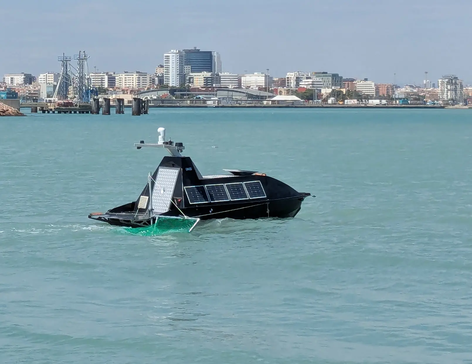
Lemvos has developed the LM450 unmanned surface vehicle (Figure 1) through a structured development process based on operational experience that has drawn upon lessons learned from many field trials of its predecessor, the LM250. By focusing on addressing known limitations, the development team designed the LM450 primarily for achieving persistent, semi-autonomous maritime surveillance with minimal human intervention required during operation. In addition, the LM450 is designed to support missions lasting up to 30 days, due in part to the vehicle’s ability to operate from unmanned docking systems and advanced energy management practices.
The LM450 is built on a 4.8-m-long HDPE hull and features a dual-thruster propulsion system and a hybrid (diesel and solar) energy source; thus, the vehicle’s design enables optimal performance against long-duration missions with continuously available energy to support all payloads during an extended storage period. Specifications and general layout are shown in Table 3 and Figure 2, respectively. As illustrated in Figure 3, the LM450 is integrated within the project monitoring and communication system architecture.Table 3—LM450 Technical Specification.
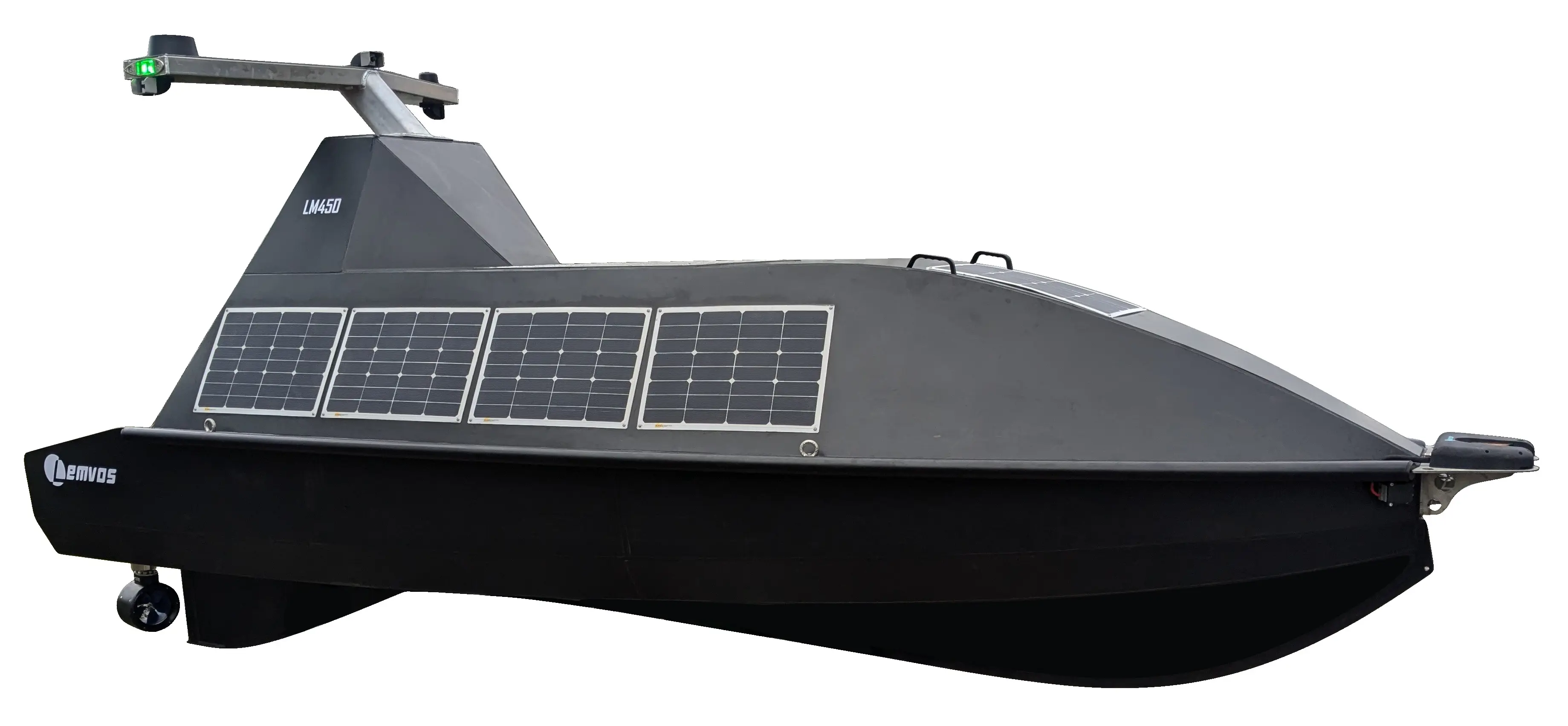
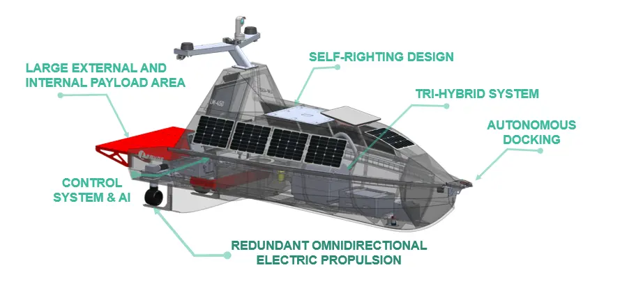
Table 3. LM450 Technical Specification.
|
General |
|
|---|---|
|
Hull Length |
4800 mm (5300 mm with payload deck) |
|
Hull Width |
1800 mm |
|
Draft |
440 mm—configuration dependent |
|
Height |
2400 mm (Mast up) |
|
Displacement |
630 kg—dry mass excluding payload |
|
Power and Energy |
|
|
Power Generation |
3.5 kW diesel generator + 350 W Solar |
|
Fuel Capacity |
170 L Diesel—Additional range extender tanks available |
|
Battery Capacity |
12.8 kWh Additional battery capacity available for pure electric version |
|
Control and Connectivity |
|
|
Controller |
Dual Redundant Lemvos AutomatePro—configuration dependent |
|
Situational Awareness (options) |
Camera, AIS receiver, Sonar, Radar |
|
Connectivity (options) |
Starlink, 4G/5G, Iridium, WIFI |
|
On Board Processor Module |
NVIDIA Jetson Orin (AutomatePro) |
|
Control Interface |
Lemvos Ground Control Station (PC based) |
|
Payload |
|
|
Max Payload |
330 kg—configuration dependent |
|
Payload Bay Available Voltages |
230 VAC, 48 VDC, 24 VDC, 12 VDC, 5 VDC |
|
Max Payload Power Supply |
2.5 kW—configuration dependent |
|
Internal Payload Volume |
1056 × 350 × 500 mm |
|
External Payload Volume |
1500 × 1200 × 1000 mm |
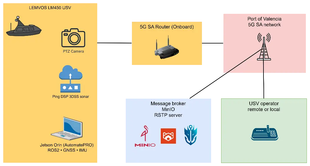
The focus of the core design will be on implementing modularity, redundancy, and adaptability for the automated vehicle; therefore, a modular payload bay and standardised electrical interfaces are created to enable the rapid installation and integration of different types of sensor suites to meet the mission’s needs. The automated vehicle has an integrated unmanned docking system with automated recharge cycles and redundant communication systems (satellite, cellular, and radio frequency) for resilient command and control. The AutomatePro (the name of the control software) supports the full range of autonomy applicable to this program, from manual operation via remote to completely autonomous execution of the mission at hand. The system supports continuous monitoring of system health and allows for the detection and reporting of faults before they affect the mission, and the ability to abort the mission if required for safety reasons. The software will run on Jetson Linux 36.3 with an NVIDIA PREREEMPT_RT kernel, which enables the applications to meet the requirements for deterministic task scheduling and extremely low latency for the control systems required for successful mission performance.
4.1.1. Hardware Platform
AutomatePro is using a NVIDIA Jetson Orin Nano 8GB System-on-Module (SOM) to enable GPU-accelerated computing for real time Sensor Fusion, Video Analytics, and Deterministic Control applications. This will provide the basis for scalable future AI/ML-based Autonomy capabilities while also allowing for efficient use of low latency hardware accelerated vision pipelines and parallel processing to process high throughput bandwidth sensors (e.g., radar, EO/IR camera, AIS receivers, Navigation payloads). The system has onboard diagnostic and health management services, providing real time diagnostics for all connected sensors, propulsion subsystems, power generation and storage, communications interfaces, and environmental sensors. It will continuously collect telemetry data and detect faults in order to provide early notification of degraded performance or anomalous behaviour, supporting predictive maintenance and automated fault handling strategies. Critical Events may result in an automatic safe state response (e.g., isolation of payload, electrical shutdown, and/or mission abort procedures).
AutomatePro provides established electrical and data interfaces (e.g., Ethernet, CAN, serial, and Digital I/O) to facilitate the integration of third party payloads and subsystems. A layered software architecture distinguishes between low-level hardware control and mission logic, allowing simple updates to the overall system and enabling rapid adaptation to new operational requirements.
4.1.2. Software Architecture
The software stack is based on Robot Operating System (ROS) 2 Humble Hawksbill, which provides a standardized middleware framework for distributed sensor integration, data communication, and system orchestration. ROS 2’s Data Distribution Service (DDS) middleware enables efficient publish-subscribe communication patterns between system components, facilitating modular development and scalability. All software components are containerized using Docker, enabling isolated execution environments, simplified deployment procedures, and enhanced system reliability. Custom NVIDIA kernel modifications were implemented to ensure seamless integration between the Jetson module and the AutomatePro.
4.1.3. Communication Infrastructure
The platform leverages 5G cellular connectivity to establish high bandwidth, low latency communication links between the unmanned vessel and remote operators or supervisory systems. This connectivity model enables responsive control, continuous situational awareness, and efficient data exchange during operations in coastal and near shore environments where terrestrial networks are available.
Key communication capabilities include:
-
-
Real time Video Streaming:
Live video streams are transmitted using H.264 compression at configurable resolutions and bitrates, allowing operators to balance image quality against available network capacity. This supports continuous visual situational awareness for navigation, surveillance, and inspection tasks with minimal end to end latency.
-
-
WebSocket based Data Visualization:
A bidirectional WebSocket communication layer enables real time visualization of sensor telemetry, system status, and mission data through browser based control interfaces. The same channel supports remote command execution, configuration updates, and mission parameter adjustments without interrupting ongoing operations.
-
-
Command and Control:
Low latency transmission of navigation and mission commands ensures responsive vessel maneuvering and precise execution of operator inputs. Priority handling of control messages is implemented to maintain safe operation even under fluctuating network conditions.
The camera driver natively implements H.264 hardware accelerated compression, significantly reducing data transmission requirements while preserving image quality sufficient for maritime surveillance, target identification, and inspection workflows. This optimization is particularly critical for sustained deployment over cellular networks, where bandwidth availability and link quality may vary due to coverage, congestion, or environmental factors. Adaptive bitrate control and stream resilience mechanisms further enhance reliability, ensuring continuous video and telemetry delivery under degraded network conditions.
4.1.4. System Monitoring and Diagnostics
Comprehensive system health monitoring is achieved through continuous telemetry collection across multiple onboard subsystems, providing operators with real time visibility into platform status and long term performance trends. Key monitored domains include:
-
-
Power System Monitoring:
Continuous tracking of generator operational status, battery voltage and current, state of charge, and fuel levels enables accurate assessment of energy availability and consumption. This information supports intelligent power management, early detection of anomalies, and optimized endurance planning for extended missions.
-
-
Navigation Subsystems:
GNSS performance is monitored through signal quality metrics such as satellite count, signal to noise ratios, fix validity, and positioning accuracy. These indicators ensure navigation reliability and enable the system to detect degradation caused by environmental interference, antenna issues, or constellation availability.
-
-
Computing Resources:
Real time monitoring of CPU and GPU utilization, memory usage, thermal states, and onboard storage capacity ensures stable operation of mission critical software components. Thermal and resource constraints can be proactively managed to prevent performance degradation or system faults during high workload conditions.
All monitoring data is published via standardized ROS 2 topics, enabling seamless consumption by onboard autonomy modules, remote operator interfaces, and data logging services. Telemetry is persistently recorded for post mission analysis, supporting predictive maintenance, root cause investigation, and continuous system performance optimization. This data driven approach enhances operational reliability, reduces unplanned downtime, and informs iterative improvements across both hardware and software components.
4.2. Sensor Integration
Modern port surveillance relies on multi-sensor integration to provide continuous all-weather situational awareness across both surface and subsurface domains. The LM450, equipped with the AutomatePro onboard controller, is designed to support this requirement through modular payload configurations that can be rapidly tailored to specific operational objectives. This modularity enables adaptive mission profiles ranging from routine perimeter monitoring- to targeted inspection and threat detection.
In the current configuration, two primary sensing modules are deployed: a Pan–Tilt–Zoom (PTZ) electrooptical camera and a Ping DSP 3DSS scanning sonar. The PTZ camera provides high-resolution visual coverage of the surface domain, supporting wide area observation, target tracking, and close-range inspection. Its pan and tilt capabilities enable dynamic reorientation in response to detected events, while optical zoom allows operators or autonomous algorithms to identify and classify targets at extended ranges without repositioning the vessel.
Complementing the surface sensor suite, the Ping DSP 3DSS scanning sonar delivers three-dimensional acoustic imagery of the subsurface environment. This capability enables the detection and localization of submerged objects such as divers, underwater vehicles, mooring infrastructure, or debris within port areas. The sonar data provides depth resolved situational awareness that is essential for safeguarding critical maritime infrastructure and detecting sub-surface threats that are not visible to optical sensors.
Both sensors are tightly integrated into the AutomatePro architecture through standardized interfaces and ROS 2 data pipelines, enabling synchronized data acquisition, time-stamped fusion, and unified presentation to onboard autonomy modules and remote operator interfaces. This multimodal sensing approach enhances detection reliability, reduces false positives, and ensures continuous operational awareness across varying environmental and visibility conditions. The configuration also provides a scalable foundation for future payload expansion, including radar, AIS receivers, environmental sensors, and additional acoustic systems, enabling the LM450 to evolve with emerging port security requirements.
4.2.1. PTZ Camera
The PTZ camera provides dynamic optical surveillance suitable for wide-area monitoring in port environments. Its ability to pan, tilt, and zoom enables both panoramic situational awareness and detailed inspection of specific surface targets. When integrated with AutomatePro’s mission software, the system supports automated object tracking and event detection, enhancing over-surface port-security operations by identifying and following vessels, personnel, or other moving objects within restricted areas. These capabilities allow the system to maintain continuous visual coverage while reducing operator workload and improving response times to potential security incidents.
4.2.2. Ping DSP 3DSS Sonar
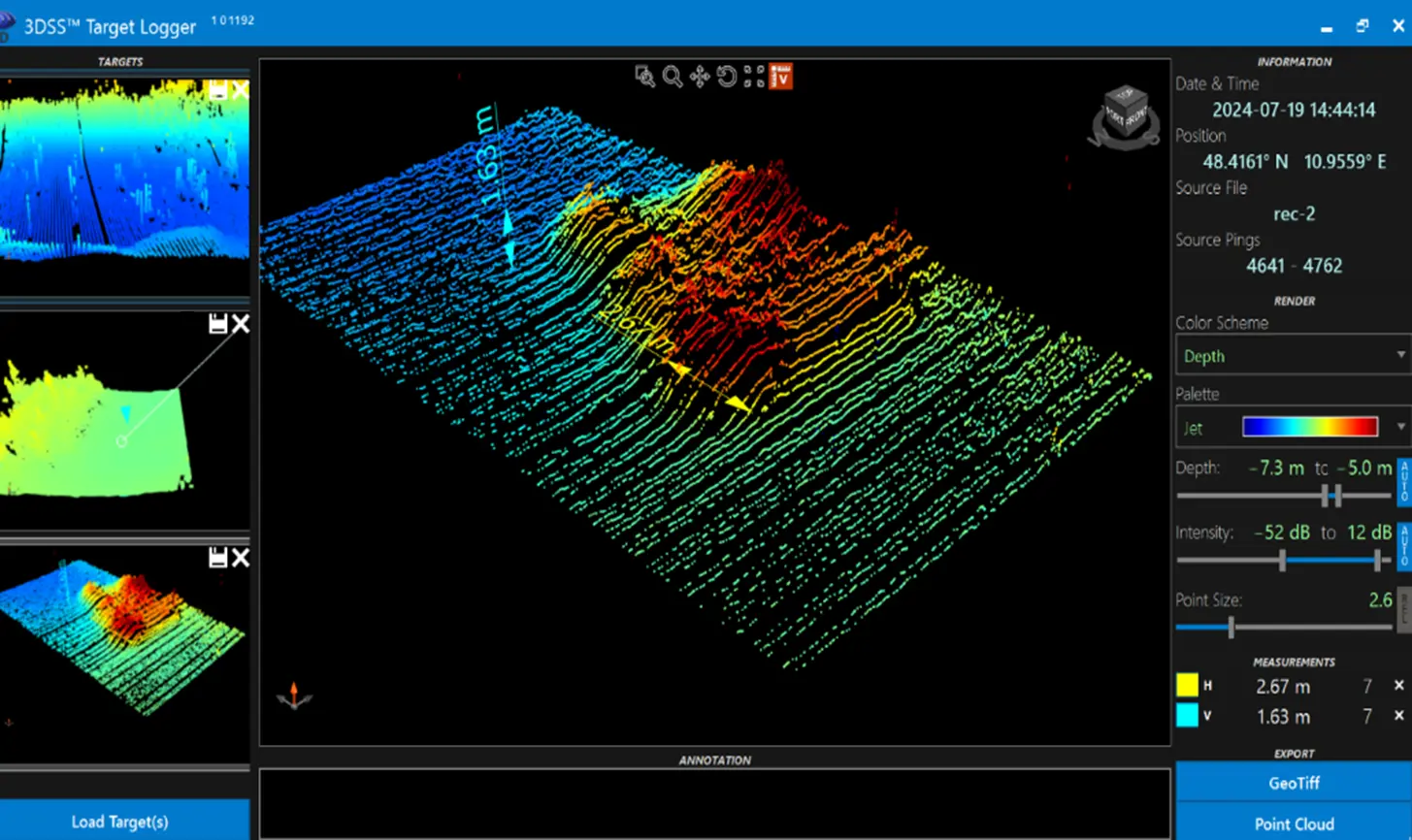
The Ping DSP 3DSS SSS extends the LM450’s detection capabilities below the waterline, providing continuous subsurface monitoring (Figure 4). Mounted on the LM450’s hull, the 3DSS delivers high-resolution volumetric imaging of underwater structures and objects, even in turbid or low-visibility conditions where optical sensors are ineffective. In a port-security context, this integration enables the detection of potentially hazardous or illicit underwater objects, such as narcotics pods, magnetic attachments, or diver intrusions, thereby enhancing the overall safety and integrity of the port environment.
5. Tests and Results
During tests carried out at Valenciaport harbour (Figure 5), the Fundación Valenciaport team did a dedicated measurement campaign using an USV equipped with a 5G signal UE configured to analyse the most significant network parameters. The USV navigated through various areas of the port waters, continuously recording key radio parameters including Signal-to-Noise Ratio (SINR), Physical Cell Identity (PCI), Reference Signal Received Power (RSRP), and Reference Signal Received Quality (RSRQ). The resulting data enabled the generation of a detailed 5G coverage map of the port area, serving both as validation of the private 5G network deployment and as a reference for future optimization efforts.
To enhance the interpretability of this massive amount of network data, FAVIT developed an Immersive Decision Support System (IDSS). Instead of relying on raw data logs, the system processes 5G KPIs (SINR, RSRP) in real-time and projects them as a geospatial heatmap overlaid on the port’s digital twin (Figure 6). This immersive visualization allows operators to intuitively identify “shadow zones” or areas with optimal connectivity (>25 dB SINR) for high-bandwidth operations.
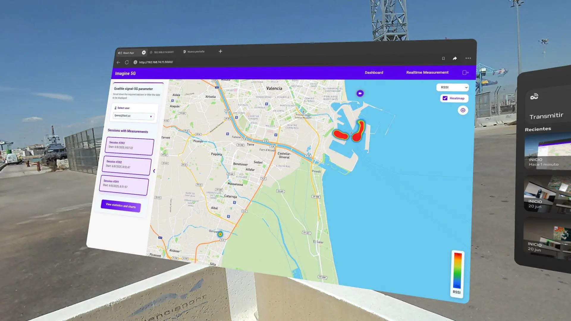
Figure 6. Immersive Decision Support System (IDSS) interface displaying real-time 5G coverage heatmaps (SINR/RSSI) over the Port of Valencia map.
By integrating these 5G coverage layers directly into the command interface, the system significantly reduces the operator’s cognitive load. This ensures that during critical missions, such as the remote piloting of the USV for the subsequent Search and Rescue (SAR) trials, the pilot can proactively maintain the vessel within the optimal 5G footprint, guaranteeing the stability of the critical Full HD video uplink required for emergency response.
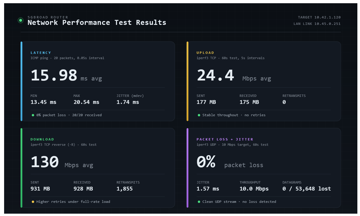
In addition to the coverage-map campaign, as shown in Figure 7, dedicated network performance tests were carried out over the 5G link using standard network benchmarking tools. Round-trip latency, measured with ICMP ping (20 packets), averaged 15.98 ms (min 13.45 ms, max 20.54 ms, mdev 1.74 ms) with 0% packet loss. TCP throughput tests over 60 s showed an uplink bitrate of approximately 24.4–24.8 Mbit/s with no retransmissions, and a downlink bitrate of approximately 130 Mbit/s, with 1855 retransmissions recorded over the test window. A controlled UDP test at a fixed 10 Mbit/s rate showed jitter between 0.000 and 1.572 ms and 0% datagram loss (0 of 53,648 datagrams) over 60 s. These results confirm that the private 5G network sustained the throughput and latency levels required for real-time video, sonar, and telemetry exchange throughout the trials.
The LEMVOS USV was deployed to evaluate its capabilities in supporting rapid response operations. During the trials, the USV autonomously launched rescue buoys and smart lifejackets toward individuals in the water while concurrently transmitting Full HD video streams for remote monitoring. The demonstrations validated the potential of 5G-enabled USVs to facilitate early accident signalization, enhance situational awareness for port authorities, and support time-critical rescue efforts with low latency and high reliability. Moreover, a study was conducted using the sonar device integrated into the USV. This sonar can generate a three-dimensional point cloud, enabling visualization of any object on the seabed, attached to a ship’s hull, or along dock walls for maintenance tasks such as crack detection. During the tests carried out at the Port of Valencia, bathymetric surveys were performed on the seabed of two docks within Valenciaport, specifically at the Xità dock and the service basin. The results revealed a higher concentration of sediment in one area than in the other; however, no weighted objects were detected on the seabed.
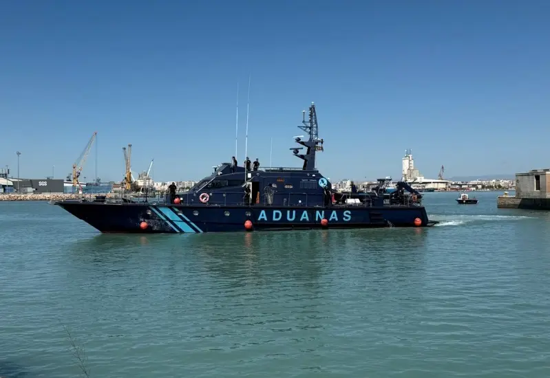
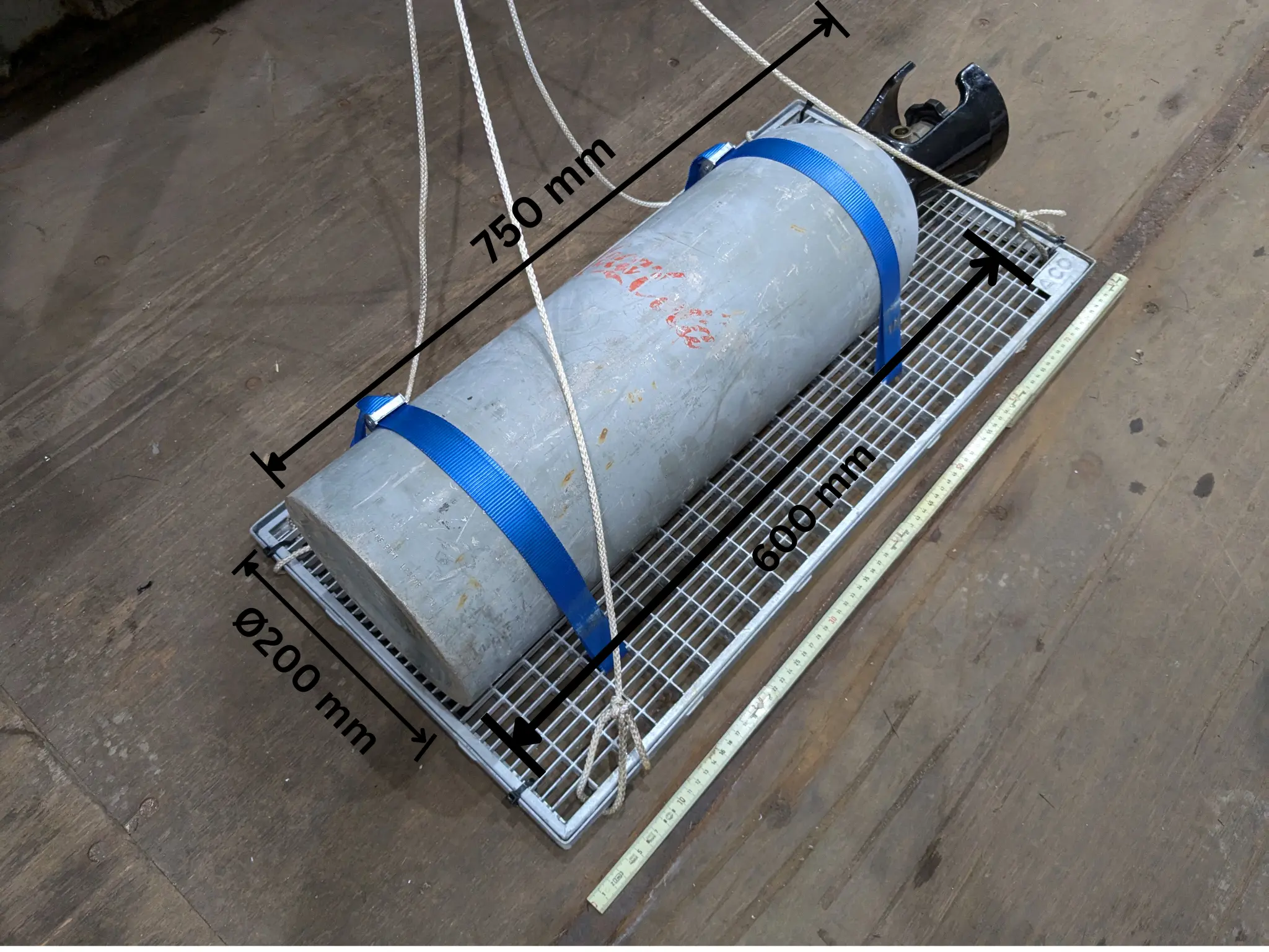
To further validate the sonar detection performance under controlled conditions, an additional experiment was carried out at an approximate operating distance of 6 m (depth) using the Customs boat (Figure 8). A representative target, consisting of a cylindrical body measuring approximately Ø200 mm × 600 mm, was magnetically attached to a flat steel panel suspended from the support vessel. The test object also incorporated an end valve and attachment features, resulting in an overall physical length of approximately 750 mm (0.75 m), as shown in Figure 9.
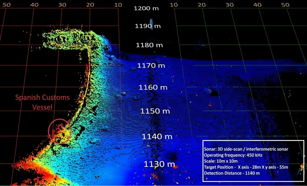
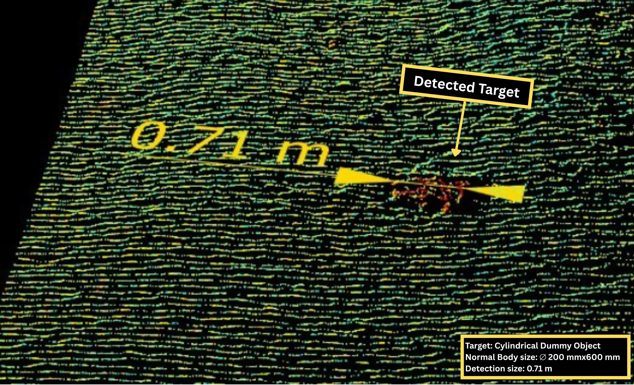
The sonar system successfully detected the target, producing a clear and consistent visualization (Figure 10), where warmer colors, particularly red, indicate the location of the bottle.The apparent target extent measured in the sonar image was approximately 0.71 m (Figure 11). This value is approximately 18% greater than the nominal 0.60 m cylindrical body length, but only approximately 5% shorter than the overall physical length of the complete test object. The result should therefore be interpreted as an estimate of the target’s acoustic extent rather than a precise dimensional measurement of the cylindrical body alone.
For port-security and law-enforcement use, reliable detection and classification are more important than precise dimensional measurement. The target produced a clear acoustic signature at approximately 6 m, demonstrating the system’s suitability for identifying suspicious hull attachments. However, dimensions from a single sonar pass should be treated as approximate due to resolution, viewing angle, and acoustic-shadow effects. Suspicious objects should therefore be reassessed from additional headings or ranges and, where necessary, confirmed using an ROV, diver, or close-range inspection system.
Although detection performance may vary depending on the hull material and geometry, these trials confirmed that cylindrical shapes are acoustically favorable targets. Different shapes were tested in a lakebed, a plastic box, and 8mm diameter ropes were successfully detected (Figure 12).
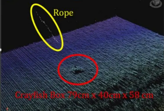
Table 4 shows that most of the sonar KPIs were met. Although the detection range was lower than the target, it has minimal operational impact, while the higher scan rate improves overall system performance.
Table 4. Sonar rapid hull scan KPIs vs actual performance achieved.
|
KPI |
Target |
Achieved Performance |
Comments |
|---|---|---|---|
|
Scan Rate |
25 m/min |
50 m/min |
Scan Rates up to 100 m/min are expected to be possible with further testing |
|
Object Detection Size (Diameter) |
200 mm |
200 mm |
Detection of ropes down to 8 mm diameter possible, with lower reliability. |
|
Object Detection Size (Length) |
500 mm |
600 mm |
Detection of 500 mm length is expected to be possible within some conditions |
|
Detection Range |
50 m |
22 m |
Results beyond 25–30 m range have more noise and are not as clear. Operationally having a detection range of 22 m instead of 50 m will have little to no negative effect. |
|
Sonar Detection Results |
Live, for a human operator this is within ~2000–5000 ms |
200–2000 ms |
Data for this KPI has been assumed as it was practically challenging to determine that exact time at which the vessel passed a given object to within less than 1 s, however the transmission timeline was analyzed to be 200–2000 ms |
6. Future Implementations
While the current deployment focuses on teleoperated navigation mode, the platform architecture is designed to support future autonomous capabilities through advanced sensor fusion algorithms.
6.1. Sensor Fusion
The system implements a multi-sensor localization framework combining GNSS positioning with inertial odometry. For future autonomous operations, an Extended Kalman Filter (EKF) will be deployed to fuse GNSS measurements, IMU data, and Visual Inertial Odometry (VIO) to achieve robust, high-frequency state estimation even during GNSS signal degradation.
The dual-antenna RTK-GNSS configuration provides absolute heading measurements independent of magnetic sensors, thereby eliminating susceptibility to magnetic disturbances. This design ensures consistent orientation estimation in environments where magnetic interference compromises IMU readings.
6.2. Autonomous Navigation
The NVIDIA Jetson Orin platform provides GPU acceleration suitable for deploying Deep Neural Network (DNN) models for future enhancements as
-
-
Image Segmentation: Semantic segmentation of water surfaces for free-path detection and path planning.
-
-
Object Detection: Real-time identification and tracking of vessels, and floating objects using convolutional neural network.
These capabilities will extend the system’s autonomy level from current human-supervised operations to fully autonomous mission execution.
These modules are envisioned as inputs to future autonomous navigation and path-planning pipelines. However, no neural network training, inference benchmarks, dataset evaluation, or autonomy performance results are presented in this paper.
7. Conclusions
Underwater control technologies significantly enhance port security, as monitoring systems, such as sonar radars, underwater cameras, and acoustic sensors, allow for the precise detection of intrusions, submerged objects, and potential structural risks. This continuous and detailed surveillance capability helps reduce the likelihood of accidents and improves the efficiency of emergency responses to situations such as leaks, sabotage, or sinkings, thereby ensuring a safer and more controlled port environment.
The experimental results obtained at the Port of Valencia confirm that the proposed system architecture is technically feasible and operationally effective in real-world port conditions. The LEMVOS USV demonstrates reliable navigation, robust 5G coverage, and sonar-based object detection capabilities.
Future developments should focus on expanding the system’s autonomy through advanced AI-based sensor fusion, object recognition, and route planning algorithms. The incorporation of machine learning models for anomaly detection and predictive maintenance will further strengthen resilience and reduce human intervention.
Statement of the Use of Generative AI and AI-Assisted Technologies in the Writing Process
During the preparation of this manuscript, the authors used the DeepSeek website to improve the English language in some sentences. After using this service, the authors reviewed and edited the content as needed and take full responsibility for the content of the published article.
Acknowledgments
This work has been carried out as part of the Horizon Europe projects SMAUG [24] and UnderSec [25]. This work is an extended version of a previously published paper [26], with expanded background, methodological details and results.
Author Contributions
Conceptualization, R.C., M.G., J.M.H. and Á.L.; Investigation, R.C., M.G., J.M.H., Á.L., F.P. and D.S.; Writing—Original Draft Preparation, R.C., M.G., J.M.H., F.P. and D.S.; Writing—Review & Editing, R.C., M.G, J.M.H., Á.L., Á.G. and S.C.; Visualization, M.G., J.M.H.; Supervision, R.C.; Project Administration, R.C.
Ethics Statement
Not applicable.
Informed Consent Statement
Not applicable.
Data Availability Statement
The data presented in this study are not publicly available due to confidentiality. They are available from the corresponding author upon reasonable request.
Funding
This research was funded by the European Union’s Horizon Europe research and innovation programme, under grant agreement N° 101121129 (SMAUG project).
Declaration of Competing Interest
The authors declare that they have no known competing financial interests or personal relationships that could have appeared to influence the work reported in this paper.
References
-
Bruwer C. Smuggling and Trafficking of Illicit Goods by Sea. In Global Challenges in Maritime Security: An Introduction; Otto L, Ed.; Springer International Publishing: Cham, Switzerland, 2020, pp. 49–73. DOI:10.1007/978-3-030-34630-0_4 [Google Scholar]
-
Romero Doniz J. Aparece un nuevo narcosubmarino en Galicia, en el interior de la ría de Arousa. La Voz de Galicia, 14 March 2023. [Google Scholar]
-
Finklea KM. Illicit Drug Smuggling Between Ports of Entry and Border Barriers [February 7, 2020]. 2020. Available online: https://api.semanticscholar.org/CorpusID:226131053 (accessed on 14 May 2026).
-
Wen CH, Hsu PY, Cheng MS. Applying intelligent methods in detecting maritime smuggling oa. Marit. Econ. Logist. 2017, 19, 573–599. DOI:10.1057/MEL.2016.3 [Google Scholar]
-
Pickman S, Howard LA. Coast Guard Interdictions and the Use of Advanced Technology by Adversaries. Am. J. Eng. Technol. Manag. 2020, 5, 96. DOI:10.11648/j.ajetm.20200506.12 [Google Scholar]
-
Dominguez G. Singapore: Making waves—Singapore’s navy looks to the future. Asia-Pac. Def. Report. 2022, 48, 33–34, 36. Available online: https://search.informit.org/doi/abs/10.3316/informit.632061983456978 (accessed on 14 May 2026).
-
Cardaillac A, Ludvigsen M. Camera-Sonar Combination for Improved Underwater Localization and Mapping. IEEE Access 2023, 11, 123070–123079. DOI:10.1109/ACCESS.2023.3329834 [Google Scholar]
-
Tani S, Ruscio F, Bresciani M, Caiti A, Costanzi R. Stereo Vision System for Autonomous Ship Hull Inspection. IFAC-PapersOnLine 2022, 55, 375–380. DOI:10.1016/j.ifacol.2022.10.457 [Google Scholar]
-
Gomathy G, Prabakaran G, Livisha K, Parasuram S, Akash Raj R. Drone Surveillance Integrated with Machine Learning for Enhanced Port Management. In Proceedings of the 2024 International Conference on Communication, Computing and Internet of Things (IC3IoT), Chennai, India, 17–18 April 2024; pp. 1–6. [Google Scholar]
-
Bisht IS. Spanish Navy Enters Unmanned Era With First USV. The Defense Post, 18 December 2025. [Google Scholar]
-
Specht C, Śliwińska D. Hydrographic Inspection Using a USV of a Harbour Bottom Deepened by the Periodic Actuation of SAR Vessel Propellers. Remote Sens. 2024, 16, 2522. DOI:10.3390/rs16142522 [Google Scholar]
-
Santos MC, Bartlett B, Schneider VE, Brádaigh FÓ, Blanck B, Santos PC, et al. Cooperative Unmanned Aerial and Surface Vehicles for Extended Coverage in Maritime Environments. IEEE Access 2024, 12, 9206–9219. DOI:10.1109/ACCESS.2024.3353046 [Google Scholar]
-
Eleftherakis D, Vicen-Bueno R. Sensors to Increase the Security of Underwater Communication Cables: A Review of Underwater Monitoring Sensors. Sensors 2020, 20, 737. DOI:10.3390/s20030737 [Google Scholar]
-
Sørensen FF, Mai C, Olsen OM, Liniger J, Pedersen S. Commercial Optical and Acoustic Sensor Performances under Varying Turbidity, Illumination, and Target Distances. Sensors 2023, 23, 6575. DOI:10.3390/s23146575 [Google Scholar]
-
Ping DSP Inc. 3DSS-DX 3D Side Scan Sonar—CAATI. Available online: http://www.pingdsp.com/techCaati (accessed on 10 June 2026).
-
Water Linked. Underwater Surveillance—Sonar 3D-15. Available online: https://waterlinked.com/applications/underwater-surveillance (accessed on 17 May 2026). [Google Scholar]
-
Das S, Malik PK, Pandey A. Challenges and Advances in Underwater Sonar Systems and AI-Driven Signal Processing for Modern Naval Operations: A Systematic Review. J. Field Robot. 2025, 43, 899–931. DOI:10.1002/rob.70077 [Google Scholar]
-
Aubard M, Madureira A, Teixeira L, Pinto J. Sonar-Based Deep Learning in Underwater Robotics: Overview, Robustness, and Challenges. IEEE J. Ocean. Eng. 2025, 50, 1866–1884. DOI:10.1109/JOE.2025.3531933 [Google Scholar]
-
P1 Security. 5G and LTE in Maritime: Private Mobile Networks for Ports, Vessels, and Offshore Operations. Available online: https://www.p1sec.com/blog/5g-at-sea-how-mobile-networks-are-transforming-the-maritime-industry?utm_source=chatgpt.com (accessed on 10 February 2026).
-
Li H, Li Z, Zhu Z, Xiao J, Wang Z, Lu Q, et al. Design of USV Remote Control System Based on 5G Communication. In Proceedings of the 4th International Conference on Control and Intelligent Robotics (ICCIR 2024), Guangzhou, China, 21–23 June 2024. DOI:10.1145/3687488.3687493 [Google Scholar]
-
Fundación Valenciaport. Valenciaport Implements Its Own 5G Connection Network, Dec. 2024. Available online: https://www.valenciaport.com/en/valenciaport-implements-its-own-5g-connection-network/ (accessed on 12 May 2026).
-
Fundación Valenciaport. Advanced Port Surveillance: 5G, Augmented Reality and Autonomous Drones—IMAGINE-B5G Project. Jul. 2024. Available online: https://www.valenciaport.com/en/advanced-port-surveillance-5g-augmented-reality-and-autonomous-drones/ (accessed on 12 May 2026).
-
Port Authority of Valencia. “The Port of Valencia”. Valenciaport. Available online: https://www.valenciaport.com/en/ports/valencia/the-port/ (accessed on 12 May 2026).
-
SMAUG—Smart Maritime And Underwater Guardian. Available online: https://smaug-horizon.eu/ (accessed on 14 May 2026).
-
UnderSec Project. Available online: https://www.undersec-project.eu/ (accessed on 14 May 2026).
-
Company R, Higón JM, Laguna A, Gabarda M, Severinsen D, Contorno S, et al. Advanced Unmanned Vehicle Systems for Port Security. In Proceedings of the 26 2nd International Conference on Drones and Unmanned Systems (DAUS’ 2026), Salzburg, Austria, 25–27 February 2026; paper 35 (009). [Google Scholar]