
Community-Based Soil and Water Conservation for Sustainable Agriculture in Lateritic South Bengal, India

Community-Based Soil and Water Conservation for Sustainable Agriculture in Lateritic South Bengal, India
Amartya Pani 1,2,* Pulak Mishra 2 Mrinal Kanti Dutta 1
Received: 13 March 2026 Revised: 29 May 2026 Accepted: 04 August 2026 Published: 01 September 2026

© 2026 The authors. This is an open access article under the Creative Commons Attribution 4.0 International License (https://creativecommons.org/licenses/by/4.0/).
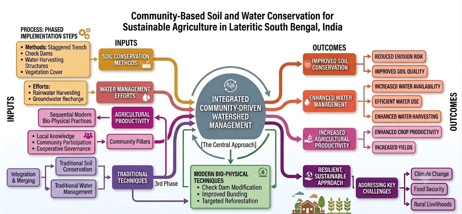
Graphical Abstract
1. Introduction
The foundation of sustainable agriculture lies in the efficient conservation and management of soil and water resources, especially in areas susceptible to climate fluctuations and land degradation. The demand for global freshwater has increased due to intensified agricultural practices and deforestation [1]. Watershed planners and agricultural producers need to understand the regional impacts of climate change on irrigation to ensure effective and sustainable water resource management, particularly as changing rainfall patterns affect natural recharge and rural livelihoods in dryland areas, thereby intensifying water stress in rainfed farming systems in West Bengal due to inefficient water use [2]. Groundwater irrigation in India needs new approaches due to climate change. While irrigation boosts crop yield, the shift from surface to lift irrigation has increased the carbon footprint. South Asian countries must promote micro-irrigation practices and design suitable surface irrigation systems for varied agro-ecological conditions. Locally adoptable, low-cost rainwater-harvesting technologies can serve as a viable alternative to conventional irrigation and water supply schemes, especially because rainwater can be harvested from any land, anywhere in the world [3]. In general, farmers have inadequate knowledge of rainwater conservation and harvesting, primarily due to limited technical knowledge and economic constraints [4]. It was found that rainfall conservation, in conjunction with proper management and the refinement of existing technologies for specific land and pedospheric characteristics, can transform the area [5].
In-situ runoff management on an agricultural farm was found to be the most efficient and least expensive method for conserving rainwater. Water harvesting increases the availability of water per unit area, lessens the impact of drought, and enables the productive use of runoff. Parts of the land can be farmed using low-external-input technologies if other factors, such as climate, soils, and crops, are conducive to the same [6]. Water-harvesting structures (WHs) can help mitigate environmental damage in dry areas experiencing desertification. Water harvesting also helps recharge groundwater aquifers. Nevertheless, implementing such structures efficiently involves knowledge of hydrology, agronomy, and society. Further, finding suitable sites for implementing the techniques is critical to their effectiveness. Stakeholders and investment agencies aim to use low-cost techniques to assess the potential of water-harvesting structures. Broadly, rainwater collection should be practical, acceptable to the local people, and environmentally sound. Engaging local communities to foster social cohesion and participation is crucial, despite potential conflicts among stakeholders. Structures, processes, and traditions influence the power and responsibilities of stakeholders. Transdisciplinary research is needed to design effective frameworks.
This study investigates modifications to agriculture and water resources in response to climate change through the lens of in situ bio-engineering structures. It emphasises how these structures, such as staggered trenches, check dams, and contour bunding, can be utilised to mitigate the negative impacts of climate variability. This paper integrates an extensive review of the current literature with empirical evidence from the field, including household surveys, focus group discussions, and case studies, to assess the effectiveness, adoption, and long-term sustainability of conservation strategies. Through case study analysis and empirical data, this study highlights the importance of integrating contemporary technologies with conventional practices to create agricultural systems that are resilient to climate change. The key objectives of this study are to analyze the role of traditional soil water management structures on agricultural productivity and water resources, investigate the role of in-situ bio-physical structures in enhancing resilience, evaluate case studies demonstrating efficacy and scope, and propose scalable frameworks across diverse regions of South Bengal, India, under the undulating red and lateritic Agro-Climatic Zone to cope with climate change. It discusses the importance of combining modern techniques with traditional practices to create resilient agricultural systems.
2. Existing Study
Climate change poses significant challenges for agriculture and water resources, threatening global food security and water supply. Changing temperatures, altered precipitation patterns, and more extreme weather events disrupt traditional farming methods and strain water sources. Solutions such as bio-engineering and traditional ecological knowledge are being used to address these issues, emphasising sustainability and resilience in the face of climate change (Table 1). In situ bio-physical structures are gaining recognition for their ability to improve water retention, soil health, and crop resilience.
Water scarcity and soil erosion are often considered the top two long-term threats to sustainable agriculture, especially in the semi-arid and lateritic areas of South Asia [7]. These issues are closely connected to soil erosion, which worsens water scarcity by diminishing the soil’s ability to retain moisture, reducing its capacity to hold moisture, and increasing surface runoff. On the flip side, water scarcity creates bare ground conditions that make soils more susceptible to erosion during intense monsoon rains [8]. In regions with lateritic soils, such as the Jhargram and West Midnapore districts of South Bengal, these processes work together: the thin, iron-rich layer with low organic matter is particularly vulnerable to being washed away when protective vegetation is stressed by dry-season water scarcity [9,10]. This creates a vicious cycle in which eroded soils lose the organic matter and structure they need to hold onto moisture, worsening water scarcity and hampering crop yields [11].
A key question in tackling these challenges is whether the water scarcity in the study area is mainly due to recent short-term events or if it reflects a deeper, long-term trend. Evidence from various sources suggests it’s the latter. In an innovative study by [12] on the unprecedented drought and water scarcity in South India, the authors found that extreme low-water periods are becoming not only more frequent but also more intense. This is largely driven by a decline in northeast monsoon performance and an increase in evapotranspiration demand due to rising temperatures, which is a trend that resonates across the wider Indian subcontinent. Looking specifically at West Bengal, analyses of rainfall trends over a long period (1901–2020) show that the western lateritic districts, such as Purulia (mean annual rainfall of 1331 ± 224 mm), Bankura (1371 ± 229 mm), and West Midnapore (1540 ± 254 mm), are the driest in the state. Notably, Purulia and Bankura have been trending towards increased dryness in recent decades (Hazra et al., 2017). Further spatiotemporal analyses of rainfall over four decades (1971–2010) reveal that the western districts of Bankura and Purulia are becoming increasingly vulnerable to water scarcity, with a general decline in yearly rainfall observed across southern and central Bengal, except for the northern sub-Himalayan foothills [13]. Additionally, the onset of the monsoon has shifted, with a noticeable shortening of the effective monsoon period in rainfed parts of West Bengal since the late 19th century [14].
As rainfall patterns shift and temperatures rise, demand for actual evapotranspiration (AET) is increasing, squeezing the effective water balance that’s crucial for replenishing soil and supporting crop growth. Research on long-term climate change in northeast and eastern India highlights that groundwater shortages in Jharkhand and West Bengal are becoming more severe due to the combined effects of heightened atmospheric demand and unpredictable monsoon patterns [15]. The Equivalent Water Thickness (EWT) trend across India, based on GRACE satellite data from 2002 to 2024, shows a worrying decline in groundwater storage, indicating a steady depletion rather than sporadic drops [16]. In Purulia district, which closely resembles Jhargram in geophysical and agro-climatic conditions, there has been a marked increase in the frequency and severity of droughts since 1992, with the most extreme negative Rainfall Anomaly Index (RAI) of −2.09 recorded as recently as 2010 [17]. This collection of evidence from decades of rainfall data, satellite observations of water storage, and local drought metrics makes it clear that water scarcity in the Kansai watershed is a deep-rooted, long-term issue rather than a fleeting problem. Addressing the agricultural sustainability challenges it brings will require lasting, community-focused solutions like those explored in this study.
Evidence from various semi-arid areas further emphasizes the significance of traditional soil-water conservation methods as viable strategies for addressing water scarcity and combating land degradation. Farmers in West Africa and South Asia often use half-moon structures to store water for sorghum and millet cultivation [18]. In both regions, resource conservation practices based on indigenous knowledge and approaches are used as climate-smart strategies, particularly to conserve moisture, limit soil erosion, and increase soil fertility in areas covered by bushes, dry, eroded valleys, and degraded, bare lands [19]. Smallholder farming groups widely use the Zai and half-moon structures in these regions to continue cultivation during the dry seasons, variable rainfall patterns, and high temperatures, despite their high labour requirements [20]. These structures appear to be successful at growing sorghum, millet, and cowpeas using animal manure or compost. While one can expect emissions from such decomposable organic matter and nitrogen fertilisers during the process, there is limited evidence on how Zai and half-moon water-harvesting structures can contribute to climate change mitigation. This leaves an important area for deeper investigation.
It has also been found that half-moons have a positive effect on crop yields when using organic and chemical fertilizers [21]. Between 1995 and 2014, implementation of the half-moon system increased cereal production by 4.1 percent per annum [22]. A half-moon irrigation system was first used in 1988 by the Burkinabe environmental services in the Yatenga region, where a large part of the soil was severely damaged. There was limited application of this strategy at scale due to a lack of training and funding to implement it in their fields. Runoff water is collected and held by a half-circled mechanical structure to enhance soil infiltration while collecting and holding runoff water. This contributes to the recovery and restoration of soil fertility for agronomic and agroforestry applications in encrusted soils [23]. Half-moons are most common in the Sahel, the central North, and the central plateau of Burkina Faso, among other places. Because they have a larger surface area than other types of WHs, half-moons can hold more water. Further, cultivation of bushes on the beds increases food yields while also ensuring that the half-moons are properly maintained [24].
Evidence suggests that micro-catchment rainwater harvesting and management (RWHM) techniques can improve crop and water productivity [25]. In the eastern dryland areas of Ethiopia, four multipurpose tree species were intercropped with grasses (Panicum maximum) in 25 m2 and 100 m2 micro-catchment areas [26]. In the wet season, the plots with micro-catchments had 31 per cent higher moisture content vis-à-vis the others. Further, the yield of grass dry matter was 32 percent higher in the 100 m2 plots as compared to those of 25 m2 [26]. In Burkina Faso, farmers could rehabilitate their land and expand cropped areas after Zai pits were developed [27]. In many parts of semi-arid India, macro-catchment systems for rainwater irrigation have increased crop and water productivity. For example, river water irrigation in the macro-catchment systems of Rajasthan and Gujarat has increased water productivity by mitigating seasonal dry spells [28]. Similarly, in the Purulia district of West Bengal, where a significant portion of rainfall is lost as runoff, tied ridges could reduce surface runoff by 60 per cent, thereby improving soil–water content by 13 per cent [29]. Further, the evidence from the drought-stricken Wollo region of Ethiopia shows that tied-ridging, open-ridging, and sub-soiling have increased soil water content in the root zone by 24 per cent, 15 per cent, and 3 per cent, respectively [30].
As a soil and water conservation measure (SWCM), agroforestry has been implemented in many countries to assist soil reclamation and restoration through plantation. Trees like shea, nere, Bengal berry, mango, and dragon fruit may generate higher farm income [31]. Fruits from these trees have high protein content and a variety of dietary minerals [32], and thus have nutritional and medicinal value, with the potential to participate in carbon markets [33]. Additionally, implementation of SWCM can improve groundwater quality and raise water tables [34].
Semi-arid tropical soils have low fertility, structural degradation, undulating physiography, and shallow depth. Soil erosion is a major issue in rain-fed areas due to insufficient vegetation cover. Deforestation and overgrazing are the main causes of vegetation loss. The population explosion has cultivated marginal and sub-marginal rainfed lands, endangering the already fragile rainfed ecosystem. Soil, water, and vegetation are limited resources that must be used efficiently to ensure the survival of humans and livestock [35]. To keep options open for farmers in the region, a viable alternative land-use system with horticultural and pastoral components may be developed. The agro-based pastoral system should be given equal priority to make use of the marginal and degraded lands in the rain-fed agro-ecosystem [36]. Several types of range grasses and legumes can be cultivated, depending on rainfall, to help supplement the depleted forage supply in these places.
Variations in rainfall and large unproductive runoff result in water scarcity in arid and semi-arid regions [37]. While rainwater harvesting and management can improve rainfed agriculture, smallholder farmers generally prefer indigenous techniques and approaches. Accordingly, half-moon water harvesting structures are widely used in such areas. Existing studies in the Indian context [38] suggest that developmental projects should focus more on indigenous soil and water conservation systems. Since the Indian state of West Bengal is home to many smallholder farmers, it is important to understand the implications of half-moon water-harvesting structures for the farming group [33].
References on Rainwater Harvesting Systems (RWHS) in rural areas help to identify the design parameters. Physiographic characteristics, such as soil type, average rainfall, and climatic conditions, are critical for selecting locations for integrated water resource management (IWRM). The problem with these approaches is that they are limited by the absence of relevant data from the study area [34]. It is difficult to perform a reliable variable analysis when rainfall data is insufficient in quantity or quality. Remote sensors and on-site verification and validation are used to determine soil characteristics. Further, geographical information systems and available cartography are used to estimate morphometric parameters of river basins [35]. Climate change projections are important when designing rainwater harvesting structures because rainfall time series exhibit spatiotemporal variability across the catchment. Finally, policies that ensure farmers receive government financial assistance and technical training to establish and maintain these systems are needed to boost agricultural productivity [36].
To ensure equitable water distribution and rational charges for water facilities, the number of Water Regulatory Authorities should encourage mandatory water audits, including those for drinking water, ensure adequate funding for the operation and maintenance of water resources projects, encourage conservation and efficient use of water by awarding prizes, and facilitate the use of efficient irrigation processes [37]. An effective national mechanism for water cooperation is required to ensure that different stakeholders and governing bodies, such as MOWR, CWC, CWPRS, CBIP, and state government agencies, work together in a cohesive, coordinated manner and with a shared understanding to avoid disputes and other issues that can obstruct effective cooperation in the field. Several farmers in Jhargram and Bankura have stopped collecting water due to various issues, including seepage. Addressing these issues requires capacity building, access to necessary materials, and institutional support.
Given that water usage has considerable cultural significance, whether for domestic or agricultural use [38], there should be active community participation. Community institutions should facilitate better practices and leverage social pressure to improve regulation, waste minimisation, and efficiency. Hence, water use efficiency, better irrigation system maintenance, lower irrigation cost per drop of water, and the ability to maximise crop production and farmer income per drop of water are all key roles of the water user associations (WUA) [39].
Table 1. Indigenous and climate-smart techniques of SWM.
|
Techniques |
Region |
Benefits |
Challenges |
References |
|---|---|---|---|---|
|
Half-Moon Structures |
West Africa, South Asia |
Improves water retention, soil fertility, and crop yields |
High labor, limited funding, and scaling issues |
|
|
Zai Pits |
West Africa |
Enhances soil moisture, fertility, and land rehabilitation |
Labour-intensive, limited mitigation evidence |
|
|
Micro-Catchment RWHM |
Ethiopia, Burkina Faso, India |
Boosts soil moisture, crop productivity |
Needs precise design, data limitations |
|
|
Macro-Catchment Systems |
India (Rajasthan, Gujarat) |
Mitigates dry spells, increases water productivity |
Infrastructure costs, maintenance needs |
|
|
Tied-Ridging |
Ethiopia, India |
Reduces runoff, improves soil water content |
Requires technical support, scalability issues |
|
|
Agroforestry |
Burkina Faso, India |
Enhances soil, farm income, and groundwater quality |
Long-term investment, deforestation risks |
|
|
Policy & Community |
Global |
Promotes equitable water use and efficient irrigation |
Coordination issues, insufficient support |
Source: Compiled and updated from various literature.
3. Methodology and Data Collection
This study employed a multistage sampling technique to investigate soil and water conservation (SWC) practices in the Kansai (Kangsabati) watershed, Lateritic South Bengal, India. The methodology was designed to ensure representativeness, minimise bias, and address challenges associated with rural data collection, such as incomplete census records. Below, we outline the hierarchical sampling process, data collection methods, and analytical approach, emphasizing clarity and alignment with the study’s objective of informing sustainable agricultural practices.
3.1. Study Area Selection
In the first stage, the districts of Jhargram and West Midnapore in West Bengal were purposively selected for their pronounced soil erosion challenges and widespread adoption of physical soil and water conservation (SWC) measures. These districts are critical agro-ecological zones characterized by lateritic soils and significant land degradation, making them ideal for evaluating the effectiveness of SWC interventions. Key physical factors include high soil erosion rates driven by undulating topography and intense monsoon rainfall, while socio-economic factors include a predominance of smallholder farmers who rely on agriculture and have limited resources to combat land degradation. In the second stage, the Kansai (Kangsabati) watershed was selected within these districts due to severe watershed degradation, as evidenced by elevated soil loss and reduced water retention capacity, necessitating robust SWC practices. This selection ensures a focus on areas facing pressing environmental and agricultural challenges, thereby optimizing the study’s relevance to sustainable land management.
3.2. Household Sampling
To assess SWC practices at the household level, two villages within the Kansai watershed, Dharsa (Jhargram district) and Dherua (West Midnapore district, 28 km from the district headquarters), were selected. These villages were chosen for their rural characteristics and active SWC implementation. A total of 92 farm households were sampled (comprising 44 households from Dharsa and 48 households from Dherua) using a two-step process to ensure an unbiased and representative sample:
Household List Compilation: A comprehensive list of households in each village was compiled using local administrative records, consultations with community leaders, and census data.
Sampling Technique: The initial household was selected via simple random sampling, followed by systematic sampling, with every n-th household (n = 4) selected to achieve an even spatial distribution across the geographically dispersed communities. This approach was selected for its efficiency, cost-effectiveness, and ability to minimise selection bias. In cases where a selected household was unavailable or declined to participate, the next eligible household was surveyed while maintaining the systematic sampling sequence.
3.3. Data Collection
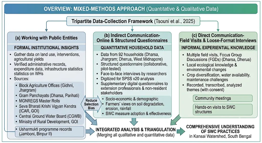
A mixed-methods approach was adopted to collect robust quantitative and qualitative data, ensuring a comprehensive understanding of SWC practices. In line with the tripartite data-collection framework used (Figure 1) in similar community-based environmental studies [40], this research organized its data gathering into three interconnected channels: (a) interacted with public entities to collect data, (b) engaging with the general public through online surveys and structured questionnaires, and (c) connecting directly with the public via field visits and informal interviews that captured farmers’ real-life experiences. Each of these channels, which reduces selection bias, gathers both formal institutional insights and informal experiential knowledge about soil and water conservation in the Kansai watershed in South Bengal.
Interacted with public entities to collect data: We gathered data on land use, watershed interventions, and agricultural yields from sources like the Block Agriculture Offices (Gidhni, Jhargram), Gram Panchayats (Dharsa and Parihati), the Master Rolls of the MGNREGA (Effective 1 July 2026, the Mahatma Gandhi National Rural Employment Guarantee Act (MGNREGA), 2005 was repealed and replaced by the Viksit Bharat—Guarantee for Rozgar and Ajeevika Mission (Gramin) [VB–G RAM G] Act, 2025), the Annual Action Plan of Seva Bharati Krishi Vigyan Kendra (ICAR, GOI, 2018–2019), the Central Ground Water Board, and the Ministry of Rural Development, Government of India. These provided us with verified administrative records, expenditure data, and infrastructure statistics on water-harvesting structures (WHs) that we couldn’t have obtained through community surveys alone. The records from the Usharmukti programme in the Jamboni and Binpur II blocks were especially useful for piecing together the timeline of watershed interventions and their tangible outcomes.
Indirect Communication-Online and Structured Questionnaires: In this study, we collected indirect data from 92 households in Dharsa (Jhargram) and Dherua (West Midnapore) using a carefully crafted, structured questionnaire. This questionnaire was developed in collaboration with extension officers and underwent a pilot test before we rolled it out. The survey aimed to capture a variety of information, including (i) socio-economic and demographic details, (ii) farmers’ views on soil degradation, erosion, and changes in rainfall patterns, and (iii) how well soil and water conservation (SWC) measures are being adopted and their effectiveness. The researcher conducted face-to-face interviews, and we later digitised the responses for analysis using SPSS version 20. To expand our understanding, we also distributed supplementary digital questionnaires to extension professionals and non-resident stakeholders through our professional networks, ensuring a wider range of perspectives.
Direct Communication-Field Visits and Loose-Format Interviews: The third channel focused on building a strong connection with farming communities by conducting multiple field visits and hosting focus group discussions (FGDs) in the villages of Dharsa and Dherua. These interactions provided valuable insights into farmers’ views, local ecological knowledge, and experiences with environmental change. Community meetings and hands-on visits to soil and water conservation (SWC) structures sparked conversations about water availability, crop diversification, and maintenance challenges. With the farmers’ consent, we recorded these discussions and analysed themes to enrich and validate the findings from our quantitative surveys.
3.4. Data Analysis
The survey data were analyzed using SPSS version 20. Descriptive statistics, such as frequencies and percentages, were utilized to summarize household characteristics, the adoption of soil and water conservation (SWC) measures, participation in watershed activities, maintenance practices, and farmers’ perceptions. To assess whether the observed proportions of binary responses (e.g., adoption, participation, and maintenance) deviated significantly from an equal (50%) distribution, one-sample z-tests for proportions were conducted. For variables with more than two response categories, chi-square (χ2) goodness-of-fit tests were used to evaluate if the observed distribution significantly differed from a uniform distribution across categories. A significance level of p < 0.05 was set for all statistical tests. These inferential analyses allowed the study to ascertain whether the observed behavioral patterns indicated systematic preferences rather than random fluctuations, thus providing robust statistical backing for interpreting farmers’ adoption, participation, maintenance behavior, and preferences for various SWC practices.
The methodology enabled a robust assessment of SWC practices, demonstrating their effectiveness in mitigating soil erosion and enhancing agricultural sustainability in the two districts across the Kansai watershed of South Bengal. Despite temporal constraints and the limited selection of only two villages, the study provides valuable insights into the successes and challenges of SWC interventions. The mixed-methods approach and rigorous sampling design ensured data reliability, while the policy review and case studies enhanced the relevance of the findings for sustainable land management.
4. Discussion
4.1. Indigenous Soil and Water Conservation Measures
Traditional soil and water conservation practices, such as contour furrows and surface runoff diversion ditches, are widely used in the study area. Contour furrows, utilized by 72% of farmers, act as barriers to prevent erosion during crop growth. Surface runoff diversion ditches, used by 17.4% of farmers, help channel runoff away from cropland. Additionally, conservation methods such as staggered trenches and check dams have been adopted by 72% of respondents (Table 2) with assistance from extension officers.
However, the effectiveness of these methods is limited by frequent cultivation and a lack of maintenance. Farmers in the area prefer the 30–40 model over soil bunds because it preserves topsoil and allows for nearby crop growth (Table 2). Despite the presence of various conservation structures, such as check dams, many lack the necessary supporting measures, leading to ineffective control of soil erosion and land degradation. One experienced male farmer, Khagen Murmu, from Dharsa Village, as depicted earlier, reported that during heavy rains, the topsoil used to wash away into the nearby stream. After the trenches and contour furrows were made, we noticed that more soil stayed in the field, and the water flowed much more slowly. Collaborative efforts by local communities, government bodies, and non-governmental organizations have implemented a range of physical soil and water conservation measures in the study area. While traditional practices play a crucial role, modern techniques are also being utilized to enhance land productivity. Overall, there is a need for improved maintenance and supportive measures to address soil erosion and land degradation more effectively in the study area.
Because contour furrows are simple to create with our own labor, we continue to trust them, just as our fathers did. We know how they operate. Although they need outside assistance, the new structures are also beneficial—Jadunath Halder, Dharsa Village, FGD
4.2. Community Participation in SWC Technologies
The active participation of farmers in soil and water conservation planning is crucial for maintaining implemented structures and ensuring their sustainability [41]. The importance of farmer cooperation in reducing soil erosion was emphasised. In the study area, 80% of farmers used watershed management techniques, including physical soil and water conservation measures [42]. However, community participation was limited to implementation rather than all stages of the process, contrary to national guidelines. Farmers participated in SWC practices through various approaches: 54.1% volunteered for free community participation, authorities required 33.8%, and 12% were motivated by payment (Table 3 and Table 4). Some farmers received incentives, such as Food-for-Work or Cash-for-Work, for building conservation structures. Those who lacked interest in SWC practices were sometimes forced to participate by government or community leaders during labor shortages. Some farmers expected incentives for maintaining SWC structures, but this may not be sustainable for land management. Overall, promoting farmers’ ownership and continuous awareness of the importance of soil and water conservation is key to the successful implementation and maintenance of SWC measures.
The overall participation rate of 80.4% should not be construed as an indication of robust community ownership, as the nature of participation exhibited considerable variation: 54.1% was voluntary, 33.8% was compelled, and 12.2% was driven by incentives (Table 2 and Table 4). The literature on participatory development distinguishes between authentic, self-motivated participation and participation influenced by external pressures or material rewards, with the latter typically associated with diminished ownership and reduced long-term sustainability [43]. A male farmer from Dherua Village shared, ‘We participated in the Food-for-Work programme primarily due to the availability of wages. Once the project concluded, there was no assistance for maintenance’. This differentiation is evident in the current study, where, despite a high participation rate, only 20.7% of households reported maintaining SWC structures. These results imply that the quality of participation, rather than the rate of participation alone, serves as a more significant measure of long-term stewardship and should be explicitly included in future assessments of SWC.
4.3. Management and Maintenance of Physical SWC Measures
Regular maintenance and management of implemented SWC structures are essential for their functionality. While a higher proportion of farmers have implemented improved SWC practices on their farmland, the effectiveness of these measures has been inadequate due to poor maintenance and management. Farmers often do not repair these structures, as there are no regular maintenance activities once they are implemented through public campaigns or incentives. Farmers expect incentives to maintain existing structures, yet the focus is often on building new ones rather than repairing them.
The notably low maintenance rate of Soil and Water Conservation (SWC) structures, recorded at 20.7%, emerges as the most significant outcome of this research, as it underscores a considerable disparity between initial implementation and enduring sustainability. While adoption rates (65.2%) and participation levels (80.4%) were relatively elevated, a majority of households failed to maintain the structures, suggesting that mere construction is inadequate for achieving lasting conservation results (Table 2). The identified reasons for the lack of maintenance, such as limited awareness (42.5%), loss of arable land (31.5%), and shortages in labour (15.1%), indicate that the issue is both institutional and technical in nature (Table 3). Farmers typically receive assistance during the construction phase but do not benefit from follow-up training, consistent extension services, or clearly defined maintenance responsibilities following project completion. This pattern aligns with the findings of [44,45], who found that a single extension contact during the construction phase, without ongoing follow-up after construction, was a significant predictor of the abandonment of conservation structures in watersheds in India and Ethiopia, respectively. Additionally, smallholders encounter opportunity costs when conservation structures diminish productive land, and the ongoing labor demands remain unsupported. These insights imply that effective SWC programs must extend beyond mere asset creation to encompass ongoing technical support, capacity building for farmers, community-driven maintenance strategies, and dedicated financial or institutional backing for post-construction care. A seminal study by [46] addressed the need to move beyond one-time construction support toward continuous institutional assistance, including Gram Panchayat-led maintenance, regular extension follow-up, and practical training on structure-specific repairs. In the absence of such initiatives, the long-term effectiveness of SWC investments is likely to be constrained, despite high initial participation levels. A marginal farmer, Trilok Mandal from Dherua, explained that the conservation structures help water stay in the field, but they also occupy part of my land. For small farmers, every piece of land matters.
Awareness-raising and revision approaches could improve participation in the implementation of conservation measures. Factors such as awareness level, land and labor availability, and economic options can affect farmers’ interest and effort in maintaining SWC structures. Lack of awareness, structures occupying cultivable land, labor shortage, and insignificant erosion on farmland are common reasons cited by communities for not managing and maintaining SWC structures. There is a need for reliable awareness-raising among farmers about the benefits of SWC practices. Agricultural extension agents could play a crucial role in disseminating information and enhancing willingness to adopt new SWC interventions and maintain existing ones. However, farmers in the study area reported limited contact with development agents and a lack of training on soil-water conservation strategies as hindrances to managing and maintaining conservation structures. Training and participation in such programs have been shown to positively affect the adoption and management of physical SWC measures, as reported in previous studies.
“Young individuals relocate for employment opportunities. Each year, there are only a handful of residents remaining in the village to maintain these buildings”—Mr. Sudha Mahato, Village committee member
Table 2. Response of sample households on current use of SWC practice in Kansai Watershed, Jhargram and West Midnapore, South Bengal.
|
Variables |
Frequency |
Percentage |
|---|---|---|
|
Use of the enhanced SWC measure |
||
|
Yes |
60 |
65.2 |
|
No |
32 |
34.8 |
|
Total |
92 |
100 |
|
Types of improved SWC structures in the study area |
||
|
Staggered Trenches |
25 |
41.6 |
|
Check Dam |
18 |
30.1 |
|
30–40 Model |
12 |
20 |
|
Soil Bund |
5 |
8.3 |
|
Total |
60 |
100 |
|
Indigenous methods for the conservation of soil and water |
||
|
Contour furrow |
66 |
71.7 |
|
Water way |
16 |
17.4 |
|
Surface runoff diversion ditch |
10 |
10.9 |
|
Total |
92 |
100 |
Table 3. Farmers’ perception of participation in SWC practices in the Kansai Watershed, Jhargram and West Midnapore, South Bengal.
|
Variables |
Frequency |
Percentage |
|---|---|---|
|
Have you participated in watershed management practices? |
||
|
Yes |
74 |
80.4 |
|
No |
18 |
19.6 |
|
Participation methods in watershed management frameworks |
||
|
Thirty days of complimentary involvement in community activities related to SWC practices. |
40 |
54.1 |
|
Compelled to take part. |
25 |
33.8 |
|
Safety Net initiative and additional assistance. |
9 |
12.2 |
|
Total |
74 |
100 |
Table 4. Farmers’ response on repairing and sustainability of SWC structures, Kansai Watershed, Jhargram and West Midnapore, South Bengal.
|
Variables |
Frequency |
Percentage |
|---|---|---|
|
Have you kept up with SWC structures? |
||
|
Yes |
19 |
20.7 |
|
No |
73 |
79.3 |
|
Why weren’t the SWC structures maintained? |
||
|
Ignorance |
31 |
42.5 |
|
Structures occupy cultivable land |
23 |
31.5 |
|
Deficiency of labor |
11 |
15.1 |
|
Nominal erosion |
5 |
6.8 |
|
Other reasons |
3 |
4.1 |
|
Total |
73 |
100 |
The statistical analysis of adoption, participation, and maintenance behaviours among sample households in the Kansai Watershed provides quantitative confirmation of patterns that are often only reported descriptively in SWC adoption studies and reveals a noteworthy disconnect between initial uptake of conservation measures and their long-term maintenance (Table 5).
Table 5. One-sample z-test for proportions (Yes/No variables).
|
Variable |
Yes (n) |
No (n) |
Total |
$$\boldsymbol{\hat{p}}$$ |
z-Value |
p-Value |
Significance |
|---|---|---|---|---|---|---|---|
|
Use of enhanced SWC measure |
60 |
32 |
92 |
0.652 |
2.92 |
0.0035 |
Significant (p < 0.01)—adoption rate significantly exceeds 50% |
|
Participated in watershed management |
74 |
18 |
92 |
0.804 |
5.84 |
<0.0001 |
Highly significant—participation rate significantly exceeds 50% |
|
Maintained SWC structures |
19 |
73 |
92 |
0.207 |
−5.40 |
<0.0001 |
Highly significant—maintenance rate significantly below 50% |
z = ($$\hat{p}$$ − 0.50)/√[0.25/n], where $$\hat{p}$$ is the observed sample proportion. The test evaluates whether the observed proportion differs significantly from the hypothesized proportion of 0.50.
The one-sample proportion tests confirm that adoption (65.2%, z = 2.92, p < 0.01) and participation (80.4%, z = 5.84, p < 0.001) were both significantly higher than chance, while structure maintenance (20.7%, z = −5.40, p < 0.001) was significantly lower. This pattern reveals a clear adoption-participation-maintenance gap: farmers readily adopt enhanced SWC structures and engage in watershed activities, but few sustain these structures afterwards. Given that ignorance (42.5%) and plot encroachment (31.5%) were the leading reasons for non-maintenance, the bottleneck appears to lie not in initial uptake but in post-construction stewardship, pointing to a need for stronger farmer training and maintenance-linked incentives rather than further adoption-focused interventions. In this perspective, a marginalised village farmer of Dherua Nitynanda Tudu urged that “if the Gram Panchayat were to hold an annual maintenance day, most farmers would likely take part. Individually, no one is willing to assume responsibility”.
The chi-square goodness-of-fit tests reveal (Table 6) that farmers’ choices across all four categorical variables show a significant deviation from a uniform distribution. This indicates that their household decisions are influenced by systematic patterns rather than random chance. When it comes to improved soil and water conservation (SWC) structures, Staggered Trenches and Check Dams together account for over 70 per cent of the adoption (χ2 = 14.53, df = 3, p < 0.01). This likely reflects their relative ease of construction and their fit with the watershed’s sloped terrain, especially compared to the more resource-intensive 30–40 Model or Soil Bund. The preference for indigenous methods is even more pronounced, with Contour Furrow leading the way at 71.7 percent (χ2 = 61.65, df = 2, p < 0.0001). This suggests that the traditional practice remains very much alive, likely due to its low cost and compatibility with existing cropping patterns, even as engineered structures gain popularity.
Table 6. Chi-square goodness-of-fit tests (multi-category variables).
|
Variable |
Categories |
χ2 |
df |
p-Value |
|---|---|---|---|---|
|
Types of improved SWC structures |
Staggered Trenches (25), Check Dam (18), 30–40 Model (12), Soil Bund (5) |
14.53 |
3 |
0.0023 |
|
Indigenous SWC methods |
Contour Furrow (66), Water Way (16), Surface Runoff Ditch (10) |
61.65 |
2 |
<0.0001 |
|
Participation methods |
Voluntary (40), Compelled (25), Safety Net (9) |
19.49 |
2 |
<0.0001 |
|
Reasons for non-maintenance |
Ignorance (31), Plot encroachment (23), Labor deficiency (11), Nominal erosion (5), Other (3) |
39.67 |
4 |
<0.0001 |
Participation modes also show significant disparities (χ2 = 19.49, df = 2, p < 0.0001), with voluntary involvement (54.1%) surpassing compelled participation (33.8%) and safety-net-linked involvement (12.2%). This indicates that while most people are engaging willingly, a notable minority are participating out of obligation or for incidental benefits rather than genuine interest. This distinction is important when considering the long-term sustainability of their engagement. Lastly, the reasons for not maintaining structures are highly non-random (χ2 = 39.67, df = 4, p < 0.0001), with ignorance and plot encroachment accounting for nearly 74 percent of cases. This reinforces the idea that the maintenance issues primarily arise from knowledge gaps and land-use conflicts, rather than labor shortages or natural degradation. Overall, these findings suggest that targeted interventions, such as technical training to fill knowledge gaps, designing structures that minimize plot-area loss, and creating incentives to turn compelled participants into willing stakeholders, could significantly enhance SWC sustainability in the watershed.
5. Experiences of Two Cases of Community-Involved Traditional WH Measures of South Bengal
5.1. Understanding of Staggered Trenches in Jhargram District
5.1.1. An Overview of Staggered Trenches
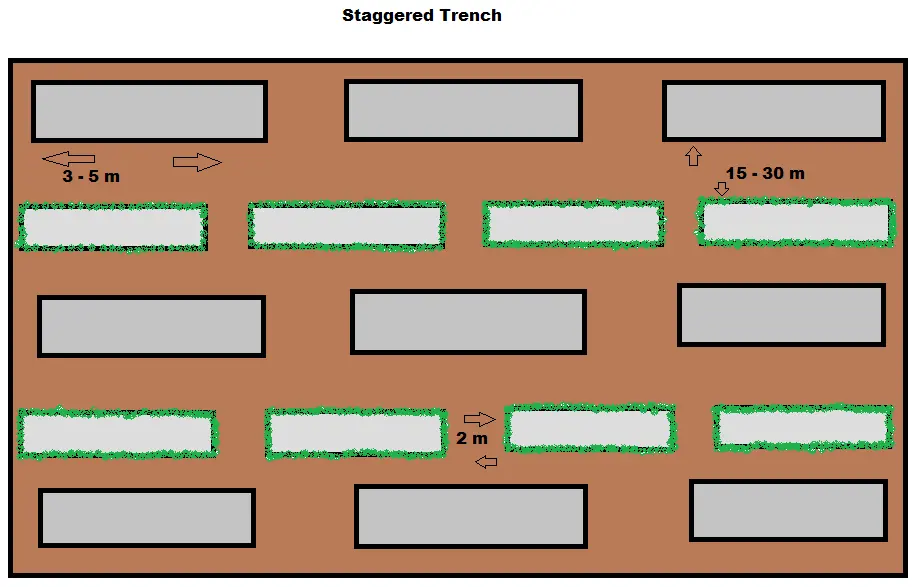
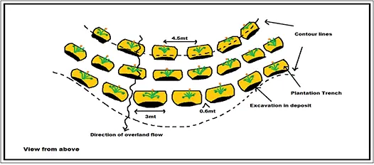
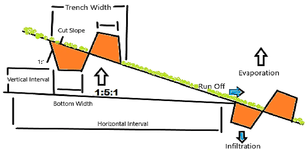
Staggered trenches are innovative soil-water management structures constructed in most villages in the western part of the Jhargram district. There is a 6-foot space between trenches dug on the same contour as well as between contour lines when digging trenches of 6′ × 2′ × 1.5′. The staggered trench has a catchment area of 96 square feet (6′ × 2′ × 6′ × 6′ × 2′) × 6″. The water harvested from this area is (96 × 2)/12 = 16 cubic feet, assuming a peak rainfall of 2 inches. The lower trench collects all the water. To provide some freeboard in each trench, the volume is kept at (6′ × 2′ × 1.5′) = 18 cubic feet. It’s covered with grass, including a sapling in each trench. There are around 1122 trees planted per hectare. It takes 84 square feet to fill the space between two identical pits on successive contours (6′ + 2′ + 6′) × 6′. Further, there are (94,185/4) × 5 = 117,731 slips per hectare of sabai and vetiver grasses planted in pits spaced 2 feet apart (Figure 2a–c). Most of these methods are less expensive and can be used where other irrigation sources are unavailable or too costly. Such water-harvesting structures conserve groundwater, reduce energy and maintenance costs, and increase crop yields while reducing the risk of failure. They also help with reforestation, fruit tree planting, and agroforestry. Importantly, such structures are widely accepted by local people. Further, compared with other structures, these structures are highly effective at reducing soil and nutrient loss. In hilly terrain, both continuous and staggered contour trenches with vegetative barriers have been found to be economically viable, and these technologies are recommended for wider adoption.
 |
|
(a) |
 |
|
(b) |
 |
|
(c) |
Figure 2. (a–c) Cross-sectional Structure of Staggered Trenches and Vegetative Cover. Source: Sketched by Author.
5.1.2. Background of the Area
Jhargram is a newly formed district of West Bengal, situated in the Kasai-Subarnarekha River interfluve zone in the western part of West Bengal’s West Midnapore district. The subdivision is part of that zone (India). It encompasses the areas between 22°48′49″ and 21°51′30″ N latitude and 86°33′50″ and 87°15′31″ E longitude (Figure 3A,B). Binpur-I, Binpur-II, Jamboni, Jhargram, Gopiballavpur-I, Gopiballavpur-II, Sankrail, and Nayagram are the eight blocks of the district with a total area of approximately 3037.64 km2 and an average elevation of 65 m above sea level. The Kasai (Kangsabati) and Subarnarekha rivers, along with their tributaries, have a significant influence on the local economy and ecology. The district represents regional diversity in physiographic and agro-climatic characteristics, economic development, and social composition. This region is a remnant of the Chhotanagpur Plateau and has undulating relief, laterite soil, and a humid climate. It can be divided into three parts: the western Chhotanagpur flanks with hills and rolling lands, the middle Rahr plain with lateritic uplands, and the eastern Chhotanagpur flanks with hills and rolling lands [47,48]. The soil is primarily sandy loam, and the average land slope ranges from 5 to 8 per cent. The summers are extremely hot, with temperatures reaching 45 degrees Celsius in May and June. Rainfall during the monsoon ranges from 997.3 to 1354.7 millimetres, accounting for 85 per cent of the total annual rainfall (June to October). Most of the land is monocropped, with only a few surface irrigation facilities available (Figure 3A,B). Paddy is the most widely planted crop in the area, along with some seasonal vegetables.
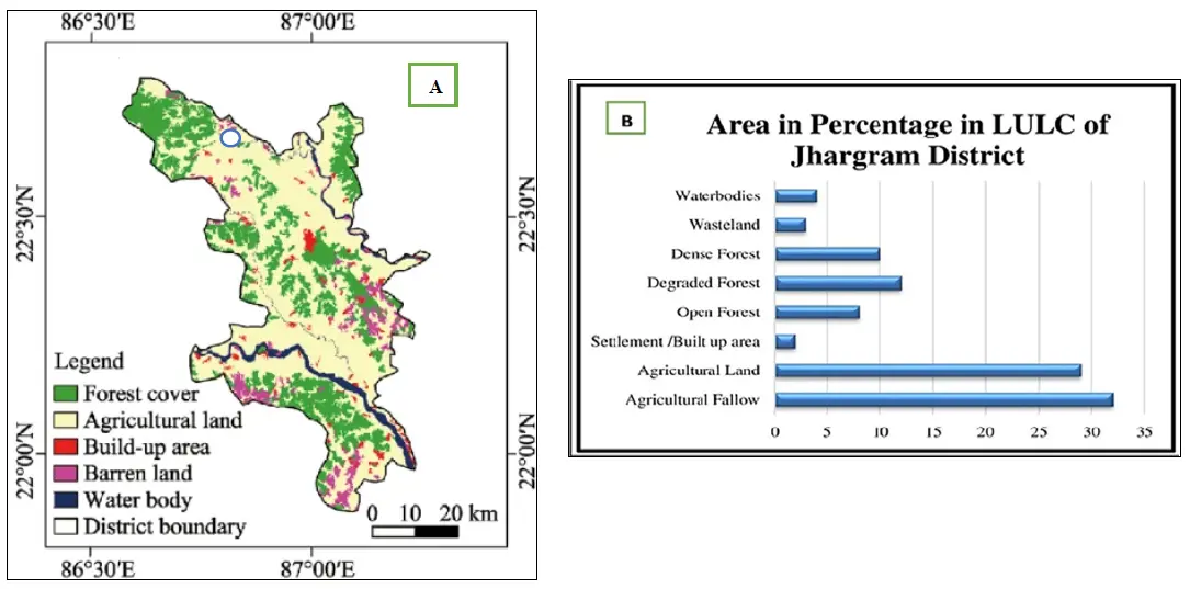
Figure 3. (A) Location Map of the Selected Village of Jhargram District; (B) LULC Statistics of Jhargram District.
5.1.3. Staggered Trench: Sustainable Soil Water Conservation Structure
Since collecting large-scale spatiotemporal data is challenging, morphometric analysis is often used to understand local hydrodynamic problems, design soil and water conservation measures, develop water resources, manage groundwater, and control erosion [49]. It is suggested that water and food security can be achieved through rainwater harvesting and the integrated use of rainwater, surface water, and groundwater, in conjunction with scientific crop water planning and multi-cropping in drought-prone, water-short areas (annual rainfall 100–400 mm). Hence, soil conservation, dryland agriculture, and other water-conservation strategies, including alternative livelihoods, would be crucial for ensuring efficient water use, thereby promoting equity and long-term sustainability [50]. Staggered trenches can help immensely on this front.
“Before these water harvesting structures, we mainly depended on one paddy crop. Now many families cultivate vegetables and earn additional income during the winter season” (Dhiren Ghosh, Farmer, Dherua Village).
However, storing runoff water through a water-harvesting structure may not be a practical option due to the highly porous subsoil and the soil’s high surface infiltration capacity (Table 7). Better options include constructing artificial recharge structures, such as percolation tanks, for groundwater development and management [51]. Further, soil erosion is less likely in a watershed with low runoff potential. Hence, biological measures such as vegetative barriers and hedgerows may be effective in controlling soil erosion. In addition, low-cost engineering measures such as contour bunding, field bunding with vegetative barriers, brushwood check dams, and loose boulder check dams may also be effective in controlling soil erosion. In the third- and fourth-order streams, permanent check dams can help replenish groundwater and stabilise the gully’s flow. The implementation of staggered contour trenches in the upstream portion of the watershed will also help conserve in-situ moisture levels [52].
Table 7. Soil and Slope-based SWM (Staggered Trench) Structure Matrix.
|
Description |
Unit |
Red or Lateritic Soil |
|||
|---|---|---|---|---|---|
|
Treatment area |
ha |
1.00 |
1.00 |
1.00 |
1.00 |
|
Slope of land |
% |
40–50 |
30–40 |
20–30 |
10–20 |
|
Number of trenches per ha |
per ha |
385 |
340 |
200 |
180 |
|
Size of one Trench |
m |
2.0 × 0.5 × 0.4 |
2.0 × 0.6 × 0.6 |
2.5 × 0.6 × 0.8 |
2.5 × 0.75 × 0.8 |
|
Volume of one trench |
cum |
0.25 |
0.45 |
0.75 |
1.00 |
|
Total Volume of trenches/ha |
cum |
75 |
98 |
145 |
198 |
|
Horizontal distance (approx.) |
m |
8.5 |
9.5 |
11.5 |
13 |
Source: FAO Guidelines for Selected SWC Practices.
Many areas of the district have a very high erosion risk, whereas the high-gradient zones are mostly covered with vegetation (Table 8). It is therefore necessary to implement conservation practices in these areas based on the landscape and soil erosion characteristics. It is possible to plant crops using a suitable cropping pattern and crop rotation, along with a community-based soil erosion management programme. Conservation tillage, contour banding, and hedgerows are possible agronomic measures under such geo-physical conditions [53]. Besides, dense forests would also help conserve soil and moisture. The estimated cost of establishing an ST over a 16.5 m2 area includes expenditures on unskilled and skilled labour, vegetal materials, and tools. As shown in the table, the total cost of labour and materials is ₹10,250, while an additional ₹1500 is required for tools, bringing the overall estimated cost to ₹11,750 per unit (Table 9). Hence, the afforestation programme in this region is critical and should be carried out with strict adherence to it.
Table 8. Soil Characteristics in Two Selected Blocks of Jhargram District.
|
Blocks |
Net Cultivated Area (Ha) |
Soil Type |
Textural Area (Ha) |
Land Situation |
||||||||
|---|---|---|---|---|---|---|---|---|---|---|---|---|
|
Predominant Soil Type |
% of Total Area |
Other Type |
% of Total Area |
Sandy |
Sandy Loam |
Clay Loam |
Clay |
Low |
Medium |
High |
||
|
Jambani |
20,450 |
Lateritic |
85 |
Alluvium |
15 |
6664 |
12,629 |
607 |
- |
9884 |
9959 |
- |
|
Binpur-II |
21,870 |
Lateritic |
95 |
Alluvium |
5 |
4566 |
16,098 |
2387 |
- |
6855 |
12,628 |
- |
Source: (Annual Action Plan, Seva Bharati Krishi Vigyan Kendra, ICAR, GOI, 2018–2019).
The remote villages in Jhargram district are undergoing transformation due to extensive water conservation works carried out with assistance under the Mahatma Gandhi National Rural Employment Guarantee Act (MGNREGA), particularly through the Usharmukti initiative. Many of these villages are characterized by undulating terrain with hilly outcrops, uneven distribution of rainfall with large amounts of runoffs, and low soil depth with less moisture retention capacity. To overcome these constraints, innovative water conservation approaches have been taken under the MGNREGA. Interventions through integrated micro-watershed development programmes under MGNREGA, NRMP, Jalatirtha, etc., with participation from the local community, NGOs, SHGs, and government officials, have led to the construction of several water conservation structures. The district is now divided into several micro-watersheds with the treatment plans developed in accordance with the principles of integrated natural resource management (INRM). Several water conservation initiatives were carried out in the Jamboni and Binpur II blocks of Jhargram (particularly in the extreme southern parts of the blocks, which housed the poorest of the Blocks in 2018–2019). The villages such as Dharsa, Chilkigarh, and Kapgari have benefited considerably from these efforts.
Since rainwater is the only source of irrigation in this area, most cultivable lands can grow only one crop in a year. For most farmers, agriculture is an extremely risky venture due to the above-mentioned factor. Almost all the medium uplands lack sufficient water for paddy cultivation (particularly during the flowering stage at the end of October) due to low soil moisture retention capacity. Despite various development measures over the past few decades, adequate livelihoods could not be guaranteed locally. Given this backdrop, modern water conservation efforts aim to rejuvenate nature and provide additional livelihoods for rural households. Initially, it was difficult to get community support for this endeavour. This may be because local communities often oppose the construction of small water bodies, citing past negative experiences with incomplete and ineffective structures that offer no benefits [54]. In the case of the staggered trenches in Jhargram, it was initially believed that large ponds do not necessarily address land- and water-related challenges. However, regular engagement helped build consensus among various stakeholders and thus supported and involved the community. Notably, some programme-level interventions have focused on rejuvenating the dying rivers and rivulets through coordinated initiatives.
Table 9. Input Costs of Constructing Staggered Trenches.
|
Input for STs of 16.5 m2 Area |
Unit Cost |
No. of Units Required |
Total Cost (INR) |
|---|---|---|---|
|
Unskilled labour |
250/day |
5 |
1250 |
|
Skilled labour |
500/day |
2 |
1000 |
|
Vegetal materials |
100 |
80 |
8000 |
|
Total cost of labour and materials |
10,250 |
||
|
Additional cost of tools |
300 |
5 |
1500 |
|
Grand total cost |
11,750 |
||
Source: Master rolls from MGNREGA of Dharsa Gram Panchayet, Jhargram.
5.1.4. Changes in Agri-Hydroscape
Through the Usharmukti programme, the community has realised its strength and ability and gained the necessary confidence to change the local ecology and economy. Fallow uplands have been covered with social forestry, check dams, and staggered trenches. There are 20 water-harvesting structures that can collect 95.7 lakh cubic feet of water per year. The harvested water is used to improve agricultural production and to recharge subsurface water. Some farmers have started cultivating brinjal using water-harvesting structures. Besides, arjuna, kaju plants on barren lands have hosted the tussar silkworm for the first time in the area and yielded a profit of Rs. 75,000 in three to four months.
Moreover, intercropping, or mixed cropping, is a system of cropping in which farmers sow multiple crops, thereby maximising land use while reducing the risks associated with single-crop failure. Such practice also increases soil organic matter and fumigated soil and restricts weed growth. The field experiences suggest five inter-cropping clusters in the catchment areas: (i) Rice + Potato, (ii) Rice + Potato + Groundnut, (iii) Rice + Vegetables, (iv) Rice + Rice + Vegetables, and (v) Rice + Potato + Vegetables. While the tube wells in the area sank, dried out, and rusted earlier due to a low groundwater level, they are now functioning again with an increase in groundwater level. Vegetal cover, along with scrub, fruit orchards, community forestation, bamboo plantations, etc., has also shown moderate spatiotemporal changes. From this perspective, one female farmer, Shanti Rani Das from Dharsa village of Jhargram, stated that- “Earlier, we mostly worked only during the paddy season. Now we also grow vegetables and manage small kitchen gardens using the stored water. We grow brinjal, tomato, chilli, okra, pumpkin, bottle gourd, cucumber, spinach, coriander, and other seasonal leafy vegetables”.
Prior to the implementation of these projects, irrigation water was available at Dharsa only during the monsoon. With the implementation of these projects, irrigation water is now available year-round. The farmers of Dharsa, with an average landholding of 2 acres, use this water to grow a variety of crops twice a year, including tomatoes, potatoes, brinjals, beans, lady’s fingers, cauliflower, cabbage, garlic, and ginger. As a result, the level of income and, hence, the standard of living of the farming households in this area have improved. Changes in the agri-hydroscape are reflected in the development of water conservation structures and related interventions, as presented in Table 10.
Table 10. Water Conservation Initiatives under the MGNREGA in Dharsa Village of Jhargram, 2017–2018.
|
Sl. No |
Water Body |
Location |
Water Volume in CU MT |
Executive Agency |
Present Work Status |
End Status |
|---|---|---|---|---|---|---|
|
1 |
Reservoir |
DHARSA-III |
2384.16 |
Gram Panchayat |
Existing |
Farm Pond |
|
2 |
Reservoir |
DHARSA-I |
1953.64 |
Gram Panchayat |
Existing |
Farm Pond |
|
3 |
Reservoir |
DHARSA-VII |
1223.54 |
Gram Panchayat |
Existing |
Farm Pond |
|
4 |
Reservoir |
DHARSA-II |
1425.30 |
Gram Panchayat |
Existing |
Farm Pond |
|
5 |
Reservoir |
DHARSA-VII |
1359.20 |
Gram Panchayat |
Existing |
Farm Pond |
|
6 |
Others |
DHARSA-II |
2229.95 |
Gram Panchayat |
Existing |
Farm Pond |
|
7 |
Others |
DHARSA-VI |
1051.97 |
Gram Panchayat |
Non-existent |
Farm Pond |
Source: Ministry of Rural Development, Government of India, 2017–2018.
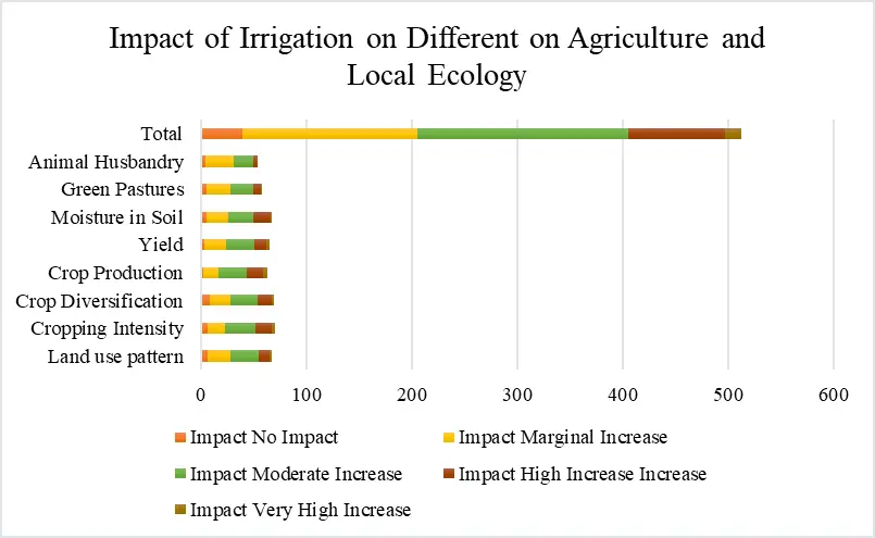
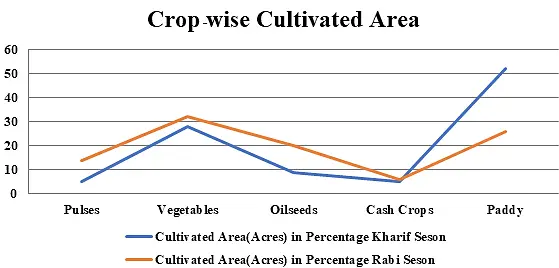
The construction of watersheds has also led to higher cropping intensity and yields in the area. Unlike the earlier practice of cultivating only paddy and mustard in the Kharif and Rabi seasons, farmers now grow maize and several vegetables, such as cucumber, spinach, gourd, bitter gourd, and pumpkin, around the bunds of water-harvesting structures, thereby increasing crop diversification (Figure 4). Water conservation in situ practices, run-off-based water harvesting on barren and upheavals lands can reduce vapor pressure deficit (VPD) and increase potential evapotranspiration ratio (PET) through greater canopy, intercropping, improved biomass and moisture content reservation in soil catena. Fruit orchards with vegetable gardens along the bunks of the structures indicate changes in the landscape of the area.
However, there is potential loss of water due to evaporation, wind drift, runoff, and water (and nutrients) sinking deep below the root zone [55]. Notably, in some areas, farmers have planted vetiver or mutha grass to control soil erosion, strengthen the bunks of harvesting structures, and reduce siltation. Since the inhabitants near the pastureland are marginal farmers belonging to the SC or ST group, rearing cattle, goats, sheep, etc., helps enhance their protein intake and strengthen their livelihoods. Construction of cattle houses under the West Bengal Comprehensive Area Development Corporation (WBCADC) through the Rashtriya Krishi Vikas Yojana (RKVY) is expected to scale up animal husbandry and promote sustainable livelihoods of the socially backward communities.
5.1.5. Other Changes in Socio-Economic Conditions
The staggered trenches have also benefited women and the self-help groups (SHGs). A rural gathering with video shows to build perspective on land- and water-based infrastructure helped address land- and water-related concerns. The exposure of the community members to other watershed areas facilitated a change in perspective and improvement in related socio-economic activities. The structures built in the watershed area helped the community understand the concept of ridge-to-valley treatment, including the excavation of staggered trenches. These exposures also helped PRI members establish a watershed perspective, vis-à-vis the idea that developing large ponds is the only solution to land- and water-based challenges.
With the possibility of year-round employment and the potential to expand livelihood options through land and water-based asset creation, Usharmukti and Mati Srishti have benefited the local women immensely. A small male farmer, Sitaram Mahato, from Dherua Village, stressed, “Even when rainfall is delayed, we are less worried because the stored water helps us save at least one crop”. These initiatives comprise a strategy to fix gullies by using a loose-boulder check to save farmland. As a part of the neighborhood’s watershed planning, the community has taken steps to conserve the farmland. For example, boulders are used in gullies to prevent soil erosion, slow surface runoff, and allow infiltration. It is expected that these measures will improve vegetation and seepage in the area. Thus, staggered trenches, with the participation of a positive community, a proactive PRI, and responsive block administration, could initiate changes in ecology, society, and the economy at the local level.
5.2. Practices of Check Dams in West Midnapore District
5.2.1. An Overview of Check Dam
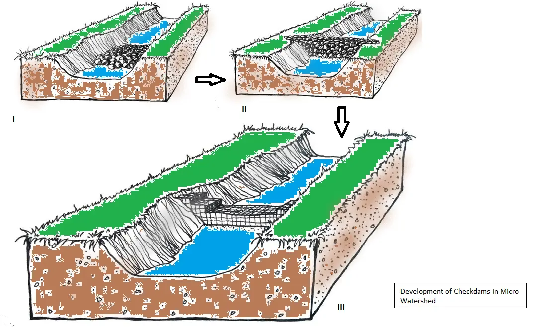
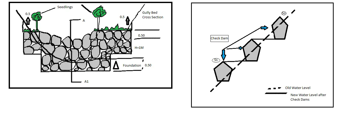
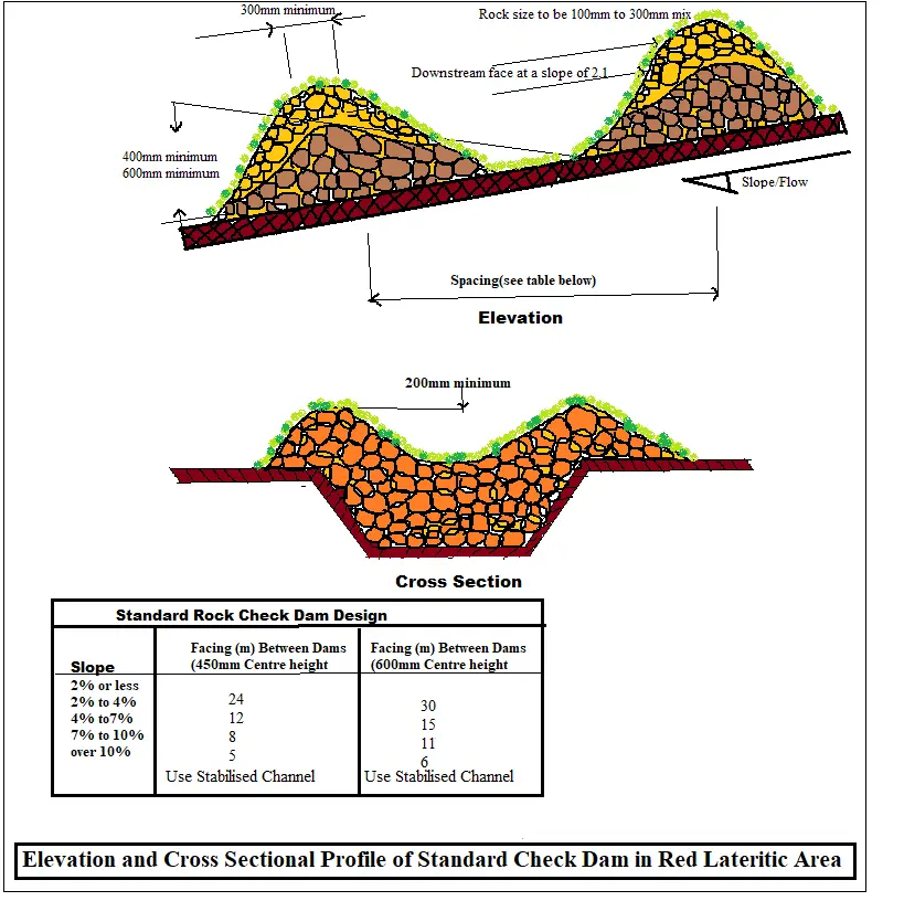
The check dams have an effective height of 30–40 cm and can be up to 6.0 m long. From 37 to 52 degrees, the inner slope of the check dams varies, and their resting angles range from 30 to 46 degrees (Figure 5a–c). Construction of Check dams is one of the most effective measures for conserving soil and water in small watersheds, and it is becoming increasingly popular. With such dams, one can significantly increase recharge to rainfall in a relatively short time. Rainwater can percolate into the aquifer through such structures because the flow velocity slows, thereby increasing infiltration time. The retention of water in such structures increases infiltration over time, thereby increasing water recharge. By constructing a check dam in flat areas with a gentle slope, a large amount of water can be stored, and the percolation rate can be increased further (Figure 5).
Engineering, especially check-dam or boulder gabion measures, is currently used for soil and water conservation. Generally, as the ground slope increases, runoff and resulting soil erosion become more pronounced. The presence of a healthy vegetation cover on flat land or terrain with a mild slope is sufficient to keep runoff below acceptable limits. However, on steeply sloped or mildly sloped grounds in a heavy rainfall zone, runoff can be so high that vegetative treatment alone cannot prevent soil erosion and water loss. In such cases, a well-balanced combination of engineering and vegetative measures is used to mitigate the problem.
5.2.2. About the Study Area
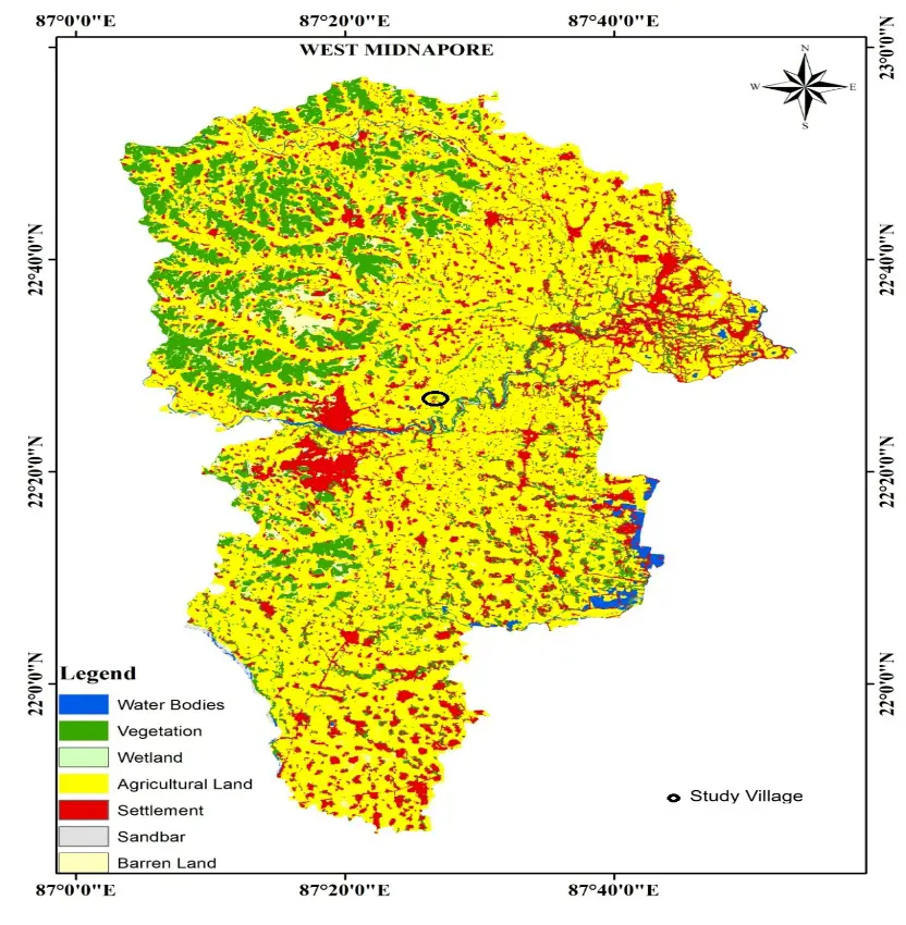
The district of West Midnapore (previously a part of undivided Midnapore) is located between the latitudes of 22°57′10″ and 21°36′35″ N and the longitudes of 88°12′40″ and 88°25′00″ E with a total geographical area of 9295.28 km2. According to the geological map of the Bengal Basin, West Midnapore had a significant impact on morphological development during the Tertiary and Quaternary periods (Figure 6a). The weathered residuals of hard rock have a high water table and are interconnected by fissures, fractures, and joints, among other means [56]. As regards the fractured and weathered zones, the depth to the water table ranges from 2 to 13 m below ground level (mbgl) during the pre-monsoon season. Lateritic soils at the surface are underlain by a thick sequence of clay, silt, and sand extending to 250 mbgl. The deep aquifers have been confined to semi-confined groundwater.
 |
|
(a) |
|
|
|
(b) |
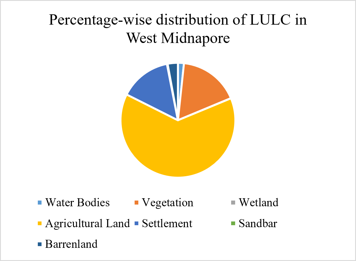
Figure 6. (a) Location Map of the Selected Village of West Midnapore District; (b) LULC based percentages in West Midnapore District.
5.2.3. Geo-Hydrological Importance of WHs: Initiation of Check Dam
Sustainable water and soil conservation methods (SWCM) reduce migration and poverty, thereby enhancing development and adaptation to climate change. Planting trees or vines alongside check dams can help control massive gullies and promote natural regeneration. If the gully is diverted and the area is enclosed to prevent grazing or other biotic harm, natural regrowth occurs. In a favourable environment, native grasses, vines, shrubs, and trees will gradually cover the gullied area. In addition, artificial regeneration can improve vegetation. However, the species chosen should be compatible with the area’s future use. Local species that can control soil erosion and are easily propagated by natural regeneration or pruning may be preferred. Nevertheless, adoption of such technologies depends directly on farmers’ income level [57] along with other factors such as their education, physical assets, organizational participation, etc. [58,59]. It is important to note that institutional and infrastructural factors, as well as government regulations, significantly impact technology adoption through crop diversification [60].
5.2.4. Spatiotemporal Changes after Check Dam Construction
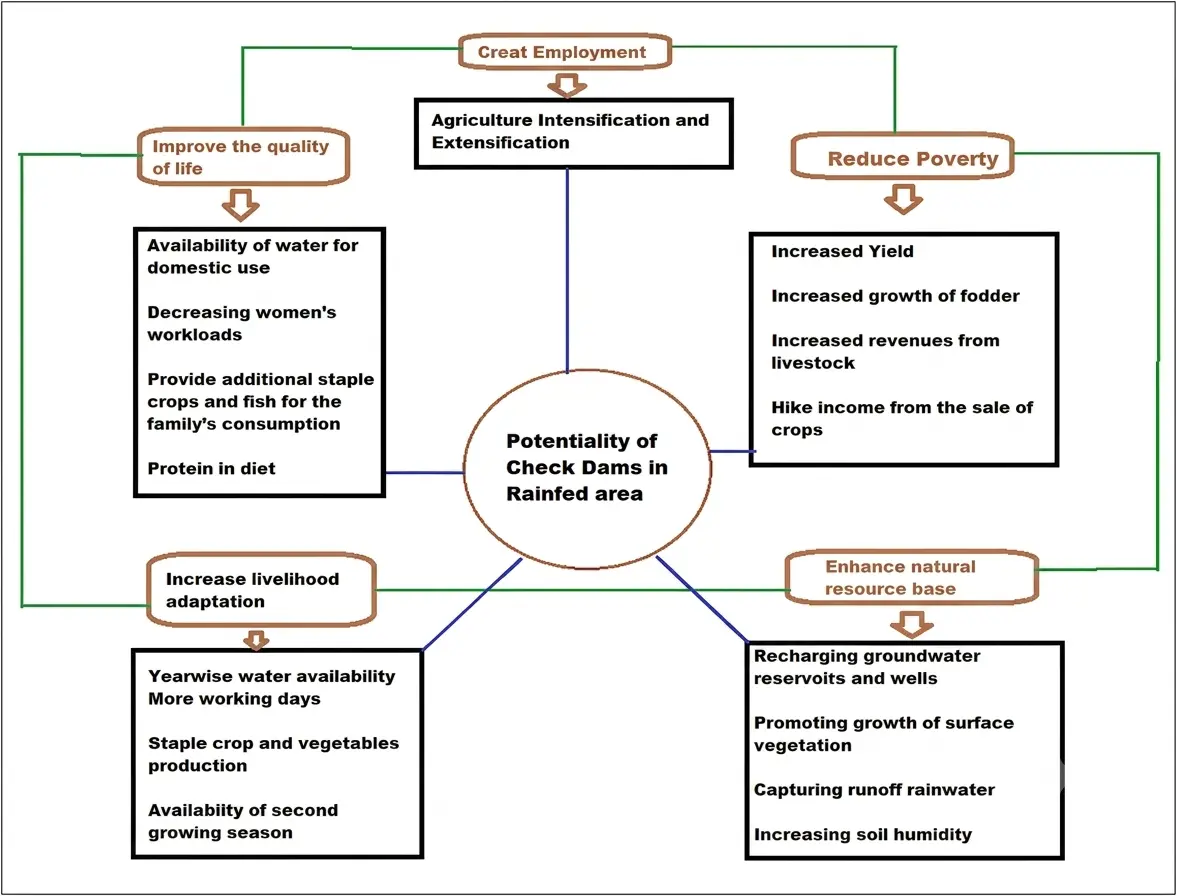
Check dams in the study area have reduced sediment yield and intensity of soil loss. However, porous check dams should be constructed in lower-catchment areas to better retain sediment. Furthermore, the construction of check dams appears to have improved soil fertility, which will aid vegetation growth in the surrounding area. Furthermore, the findings demonstrate that soil acidity decreased following the construction of the check dams. In the study area, 10 check dams were built from rocks, boulders, and gravel to prevent water from entering. In addition, the length of the check dam is adjusted in accordance with the size of the gully. In shallow rivers and streams, small barriers, such as check dams, divert water flow. These dams collect excess water during monsoon rains, and the catchment area’s pressure forces the water into the ground, replenishing groundwater reserves and wells in nearby areas. Water thus stored is used for irrigation, livestock, and various domestic purposes (Figure 7).
In India, the groundwater table has plummeted dramatically across large areas of the country [61], leaving drought-stricken shallow wells dry. Some semi-critical and critical zones of the water table raise serious concerns [62], making crop production difficult, particularly in the absence of a surface irrigation system. Under such conditions, rainwater harvesting is widely recommended to replenish groundwater, and check dams can make a significant contribution. In a typical setting, a large part of rainwater flows off a granitic surface with low infiltration and a moderate slope. Check dams slow water flow (Figure 8). However, using water harvesting for micro-irrigation is considered a better way to improve soil health. Further, agroforestry fruits and vegetables such as guavas, mangoes, okra, mustard, and bottle gourd can be grown in rainfed uplands.
Notably, very few pressurized irrigation adaptations, along with supplementary sources from check dams, have been used in this area. As a result, traditional groundwater- or surface-water-based irrigation appears to have led to fertiliser loss in the topsoil, thereby forcing farmers to use more chemical fertilisers. Often, fertiliser doses are not determined by field experiments, crop variety, water availability, and soil characteristics, as farmers lack adequate knowledge of the N-P-K ratio. Hence, restoration of soil quality through Soil organic carbon (SOC) management should be prioritized as nitrogen fertilizer reduces soil microbial activity and organic matter [63]. This is crucial, as variations in soil organic matter considerably influence carbon stocks and fluxes [64] and supply plant nutrients in cultivated soils [65].
5.2.5. Institutional Participation in Check Dam Management
Engagement of different NGOs, e.g., Development Research Communication and Services Centre (DRCSC), PRADAN, BRLF, Spectra, and Darpan in watershed development or INRM is observed in some parts of the district. Moreover, some Non-Governmental Organisations (NGOs) have been involved in changing cropping patterns and promoting crop diversification in non-irrigated areas. These lessons provide important pathways for scaling up best practices. Nevertheless, the PRIs also play a crucial role in preparing the plans in an integrated manner. They also provide capacity building for soil and water conservation activities and other interventions (Table 11). Nevertheless, the problems of elite capture, conflict over work allocation, and stakeholder identification hinder the decentralisation of power through local-level participation. Importantly, most farming communities have active female participation, and conservation of natural resources is a top priority. Women’s understanding of how to improve soil health by adding litter or crop residues is commendable [66]. The involvement of rural women in the West Bengal watershed improvement project has improved their economic situation. According to [67], women have a crucial role in agricultural and natural resource management.
Table 11. Construction and Maintenance Statistics of Water Harvesting Structures.
|
Type of Work (WHs) |
Completed Work |
Expenditure in Lakh |
No of Beneficiaries |
Area Impacted |
Storage of Water |
Person-Days Generated |
|---|---|---|---|---|---|---|
|
Check Dams |
4 |
11.50 |
28 |
11.5 |
117,500 |
2250 |
|
Staggered Trench |
200 |
1.15 |
45 |
18.5 |
4100 |
960 |
Source: Block Agriculture Office, Gidhni, Jhargram.
Due to the construction of farm ponds, dugout ponds, and check dams, particularly under the MGNREGA, the groundwater levels increased considerably in these areas (Table 12). Even the dry bore wells are now replenished, preventing the water level from depleting. The newly excavated or renovated ponds have not only ensured irrigation for monsoon crops during dry spells, thereby increasing yields, but also helped recharge groundwater. The village of Dherua has around 450 acres of arable land, and the execution of these water conservation and harvesting projects under the MGNREGA has increased water availability to meet irrigation and various domestic needs.
Table 12. Water Conservation Initiatives under the MGNREGA in Dherua Village of West Midnapore, 2017–2018.
|
Sl. No |
Water Body |
Location |
Water vol. in cu.mt. |
Executing Agency |
Present Work Status |
End Status |
|---|---|---|---|---|---|---|
|
1 |
Tank |
DHERUA-VII |
0.60 |
Gram Panchayat |
Silted |
Excavation |
|
2 |
Tank |
DHERUA-V |
0.90 |
Gram Panchayat |
Silted |
Desilting |
|
3 |
Tank |
DHERUA-VII |
0.80 |
Gram Panchayat |
Silted |
Desilting |
|
4 |
Tank |
DHERUA-I |
0.80 |
Gram Panchayat |
Silted |
Desilting |
|
5 |
Tank |
DHERUA-I |
0.90 |
Gram Panchayat |
Silted |
Desilting |
|
6 |
Tank |
DHERUA-VI |
0.18 |
Gram Panchayat |
Silted |
Desilting |
|
7 |
Tank |
DHERUA-VI |
0.70 |
Gram Panchayat |
Silted |
Desilting |
|
8 |
Tank |
DHERUA-V |
0.08 |
Gram Panchayat |
Silted |
Desilting |
|
9 |
Tank |
DHERUA-I |
12.00 |
Gram Panchayat |
Silted |
Desilting |
Source: Ministry of Rural Development, Government of India, 2017–2018.
The recent disasters in West Midnapore, namely Aila, Titli, Bulbul, and Amphan, along with frequent tropical low-pressure cyclones, caused the loss of human lives and cattle, severe damage to infrastructure, and economic losses and environmental degradation [68,69]. Furthermore, recurrent droughts, floods, and erratic rainfall have severely affected rural livelihoods. In this connection, the check dams seem to have played an important role in livelihood restoration and livestock management in different parts of the district.
6. Policy Implication
The main takeaway from the study is striking: while adoption (65.2%) and participation (80.4%) in soil and water conservation efforts are thriving, maintenance lags at just 20.7%. This suggests a clear bias in our current programs, which focus more on building new structures than on maintaining the ones we already have. We need to see MGNREGA and watershed mission budgets set aside specific funds and labor days for maintenance, separate from the goals for new construction. Gram Panchayats should be held responsible for the annual desilting and repair of existing assets. It’s concerning that a third of farmers only got involved because they had to, and that nearly three-quarters of non-maintenance can be traced to ignorance and loss of plot area. To tackle this, we should create incentive structures that promote ongoing maintenance rather than rewarding one-off construction work. Plus, extension agents and Krishi Vigyan Kendras should focus on providing ongoing, structure-specific training rather than just one-time demonstrations. Lastly, we need to ensure that the designs of these structures are tailored to the size of the landholdings, so that maintaining them doesn’t take up valuable cultivable land.
The cases highlight that achieving lasting results relies more on consistent institutions and local relevance than on one-size-fits-all solutions. To strengthen this impact, it’s essential to formalize their roles through established watershed committees that have clear maintenance responsibilities, including enhancing decision-making power for women, whose involvement has already been crucial in improving livelihoods. Additionally, the types of structures should align with local geohydrology, using staggered trenches in Jhargram’s hilly, low-infiltration areas and check dams in West Midnapore’s higher-water-table areas, rather than enforcing a uniform structure quota across different blocks. This approach should also include structure-level monitoring registers to track construction and maintenance history and beneficiary households, addressing the data gap that hindered this study’s ability to connect adoption with long-term maintenance success.
7. Limitations of the Study
This study has some limitations, including its reliance on two purposively selected villages in the Kansai watershed, which limits its generalisability to other lateritic areas. Furthermore, the small sample (n = 92 households) and the absence of a control group limit conclusions about causality. The reliance on farmers’ perceptions rather than long-term biophysical measurements makes results susceptible to recall bias. The lack of local long-term climatic and hydrological data limited the assessment of watershed-scale impacts. The study only partially captured gender and social equity dimensions, for example, by excluding women, tenant farmers, and landless households. Finally, the findings are closely linked to the institutional support offered through programmes such as MGNREGA and Ushharmukti and may therefore not be directly transferable to regions with different governance and implementation contexts. Importantly, the absence of direct biophysical measurements limits causal inference.
8. Conclusions
The study explores marginal farmers’ engagement with different water-harvesting-led irrigation structures in the dry zones of Bankura, Jhargram, and West Midnapore districts of West Bengal. The findings also identify the factors that influence water-harvesting-led irrigation structures in rainfed areas, given the agro-climatic and geo-hydrological conditions. It is found that, since the western part of the state of West Bengal receives adequate rainfall, proper management, along with trapping surface and subsurface runoff through hapa (30–40 model), staggered trench, and check dam, can increase both net irrigated area and cropping intensity. Importantly, farmers’ accounts and case evidence suggest that these in-situ WHS are associated with changes in cropping patterns and increased crop diversification through intercropping in the area. Since mango is a seasonal crop, this intercropping has helped farmers maintain a steady income during the off-season. The women members have immensely benefited in terms of income and, hence, other forms of empowerment. This seems to have helped, particularly the small and marginal farmers, by increasing their cropping intensity.
Most people in the lateritic parts of West Bengal have tiny farms and grow mainly cereals, including paddy, oilseeds, and vegetables. While sufficient water is available for farming in most parts of the state during the monsoon, developing irrigation infrastructure to sustain cultivation during the dry season requires special attention. Water scarcity during the dry season often prevents smallholder farmers from increasing cropping intensity (to increase their farm income) and diversifying their income sources (to manage risk). For instance, farmers in Bankura and Jhargram districts are unable to grow enough fodder crops to rear cattle and diversify their operations because of insufficient water during the dry season.
To overcome such constraints, the local PRIs have taken an active role in the successful implementation of various water and land conservation-related programmes of the central and state governments. Efforts are underway to construct check dams, dykes, ponds, and tanks. Initiatives have also been taken to renovate and restore traditional water-harvesting structures and to promote land protection. The initiatives undertaken under MGNREGA warrant special mention in this regard. The natural capitals thus created seem to have benefited the local communities immensely. Perhaps, the practice of decentralised rainwater harvesting has improved agricultural incomes, expanded livelihood options, and provided non-agricultural benefits to the local community and environment. This appears to be a better alternative to large-scale, centralised irrigation facilities. The active role of the PRIs in implementing related programmes, in collaboration with other government agencies, NGOs, and the local community, has been crucial in this regard.
Nevertheless, the efficient and effective use of the assets thus created and the reaping of their long-term benefits would require convergence of land and water conservation measures with other related initiatives. It is also necessary to develop the human and social capital required, particularly for efficient management and use of resources. Besides, the PRIs should also take special initiatives to build the farming community's capacity to adopt modern farming technologies and practices.
Efforts are also necessary to restore or excavate tanks, farm ponds, check dams, staggered trenches, etc., to enhance complementarities. The experiences with staggered trenches in Jhargram and check dams in West Midnapore provide evidence for such strategies. In addition, sustainable water resource conservation initiatives for irrigation, like Jalanidhi, Jaladhar, Jal Dharo-Jal Bharo (catching and storing water), and Jalatirtha by the Government of West Bengal, are likely to play important roles in this regard. Besides, training users of supplementary micro-irrigation structures, greater integration among stakeholders, greater participation of women, and enhanced awareness are also necessary to increase the benefits. There is also a need to guide farmers to cultivate appropriate crops to optimise the utilisation of water from hapas, trenches, and check dams. The extension officers and local institutions, including various organisations, can contribute immensely in this regard. Moreover, there is a need for synergy between surface and aquifer storage to attain sustainable water policy and practices.
Importantly, dissected plateaus and residual hillocks in the lateritic part of West Bengal can reduce the irrigation efficiency of different WHS. Although sprinkler or drip irrigation, along with the cultivation of drought- and lateritic-resilient low-moisture crops, can help address geophysical and climatic vulnerability, appropriate crop diversification is also necessary. Further, while different water-harvesting-led irrigation structures have shown benefits for groundwater recharge, farmers associate rainwater harvesting with higher agricultural production, and these structures require regular maintenance. Structures should be regularly desilted. The water user groups should play an active role in this regard, particularly regarding hapas on common land. Further, scientific guidance is necessary to determine an appropriate irrigation structure under different geophysical conditions.
Statement of the Use of Generative AI and AI-Assisted Technologies in the Writing Process
During the preparation of this manuscript, the authors used ChatGPT and Gemini to improve the language quality, grammar, and readability and to structure the figure. After using this tool, the authors carefully reviewed and edited the content as needed and take full responsibility for the published article.
Acknowledgement
The authors sincerely thank all the stakeholders who contributed to this study by sharing their valuable insights, experiences, resources, and time during the survey and fieldwork. Their cooperation and willingness to provide information were instrumental in completing this work. The authors also express their sincere gratitude to Ishani Ghatak for her valuable support in developing the structural figures for the study, particularly during her challenging period. Her contribution and commitment are deeply appreciated.
Author Contributions
Conceptualization, A.P., P.M. and M.K.D.; methodology, A.P. and P.M.; software, A.P.; validation, A.P. and P.M.; formal analysis, A.P. and P.M.; investigation, A.P.; resources, A.P., P.M. and M.K.D.; data curation, A.P.; writing—original draft preparation, A.P., P.M. and M.K.D.; writing—review and editing, A.P. and P.M.; visualization, A.P.; supervision, P.M. and M.K.D.; project administration, P.M. and M.K.D. All authors have read and agreed to the published version of the manuscript.
Ethics Statement
This study did not involve any invasive experimental procedures. All research activities adhered to the guidelines outlined in the Declaration of Helsinki. Ethical review and approval were waived for this study due to its non-invasive nature.
Informed Consent Statement
Not applicable.
Data Availability Statement
The data are available from the corresponding author upon reasonable request.
Funding
This work originated as part of doctoral research conducted at the Indian Institute of Technology Kharagpur, supported by the University Grants Commission (UGC) through the Senior Research Fellowship. The study was subsequently expanded, updated, and refined through additional research undertaken during the postdoctoral fellowship at the Indian Institute of Technology Guwahati, supported by the Institute Postdoctoral Fellowship. The authors sincerely acknowledge both institutions and the funding support that made this research possible.
Declaration of Competing Interest
The authors declare that they have no known competing financial interests or personal relationships that could have appeared to influence the work reported in this paper.
References
-
Kunwar S, Mishra N, Khali H, Deep A. Impacts of climate change on groundwater resources: A comprehensive review. Front. Environ. Sci. 2026, 14, 1606354. DOI:10.3389/fenvs.2026.1606354 [Google Scholar]
-
Woznicki SA, Nejadhashemi AP, Parsinejad M. Climate change and irrigation demand: Uncertainty and adaptation. J. Hydrol. Reg. Stud. 2015, 3, 247–264. DOI:10.1016/j.ejrh.2014.12.003 [Google Scholar]
-
Amanambu AC, Obarein OA, Mossa J, Li L, Ayeni SS, Balogun O, et al. Groundwater system and climate change: Present status and future considerations. J. Hydrol. 2020, 589, 125163. DOI:10.1016/j.jhydrol.2020.125163 [Google Scholar]
-
Oweis T, Hachum A. Water harvesting and supplemental irrigation for improved water productivity of dry farming systems in West Asia and North Africa. Agric. Water Manag. 2006, 80, 57–73. DOI:10.1016/j.agwat.2005.07.004 [Google Scholar]
-
Singh P, Wani SP, Pathak P, Sahrawat KL, Singh AK. Increasing Crop Productivity and Water Use Efficiency in Rainfed Agriculture. 2011. Available online: https://oar.icrisat.org/3572/1/Chapter_10.pdf (accessed on 3 August 2026).
-
Singh SV. Leveraging In-Situ Rainwater Harvesting and Crop Management: Sustainable Strategy for Soil Health Restoration, Reduced Water & Carbon Footprint and Climate Resilience. 2024. Available online:https://ssrn.com/abstract=4925835 (accessed on 3 August 2026).
-
Biswas A, Sarkar S, Das S, Dutta S, Choudhury MR, Giri A, et al. Water scarcity: A global hindrance to sustainable development and agricultural production—A critical review of the impacts and adaptation strategies. Camb. Prism. Water 2025, 3, e4. DOI:10.1017/wat.2024.16 [Google Scholar]
-
Grigorieva E, Livenets A, Stelmakh E. Adaptation of agriculture to climate change: A scoping review. Climate 2023, 11, 202. DOI:10.3390/cli11100202 [Google Scholar]
-
Hasanuzzaman M, Shit PK, Mallick J, Alqadhi S, Talukdar S. Local perspectives on gully erosion: A comparative study of farmers and non-farmers in the Chotanagpur plateau fringe, West Bengal. Nat. Hazards 2025, 121, 6677–6697. DOI:10.1007/s11069-024-07026-w [Google Scholar]
-
Biswas J, Giri B. RUSLE and AHP based soil erosion risk mapping for Jalpaiguri district of West Bengal, India. Proc. Indian Natl. Sci. Acad. 2023, 89, 869–883. DOI:10.1007/s43538-023-00197-3 [Google Scholar]
-
Anwar MR, Liu DL, Macadam I, Kelly G. Adapting agriculture to climate change: A review. Theor. Appl. Climatol. 2013, 113, 225–245. DOI:10.1007/s00704-012-0780-1 [Google Scholar]
-
Mishra V, Thirumalai K, Jain S, Aadhar S. Unprecedented drought in South India and recent water scarcity. Environ. Res. Lett. 2021, 16, 054007. DOI:10.1088/1748-9326/abf289 [Google Scholar]
-
Goswami T, Chowdhury G, Das N. Assessment of Drought Vulnerability using Standardised Precipitation Index and Multivariate Statistics: A Study on Lower Gangetic West Bengal, Eastern India. Ann. Natl. Assoc. Geogr. India 2025, 45, 163–192. DOI:10.32381/ATNAGI.2025.45.01.10 [Google Scholar]
-
Sahoo M, Saini S, Villanthenkodath MA. Determinants of material footprint in BRICS countries: An empirical analysis. Environ. Sci. Pollut. Res. 2021, 28, 37689–37704. DOI:10.1007/s11356-021-13309-7 [Google Scholar]
-
Halder B, Yaseen ZM. Long-term climate change analysis in northeast and eastern India. Geomat. Nat. Hazards Risk 2024, 15, 2409206. DOI:10.1080/19475705.2024.2409206 [Google Scholar]
-
Kersten T. Impact of Group Delay Variations on Wide-and Narrowlane Linear Combinations. In Proceedings of the IAG Scientific Assembly 2013, 150 Years International Association of Geodesy (IAG), Potsdam, Germany, 1–6 September 2013. [Google Scholar]
-
Mandal P, Roy P, Maiti A, Yadav A, Bhattacharya S, Paul S. Assessing the interplay of environmental change, cyclonic hazards, and their ramifications on agriculture in Indian Sundarban. Ocean Coast. Manag. 2024, 251, 107080. DOI:10.1016/j.ocecoaman.2024.107080 [Google Scholar]
-
Tamagnone P, Comino E, Rosso M. Rainwater harvesting techniques as an adaptation strategy for flood mitigation. J. Hydrol. 2020, 586, 124880. DOI:10.1016/j.jhydrol.2020.124880 [Google Scholar]
-
Awazi NP, Tsufac AR. Conceptual and empirical overview on soils, soil fertility, and soil macro-fauna in cocoa-based agroforests. In Agroforestry for a Sustainable Future: The Place of Carbon Credits and Markets; Palgrave Macmillan: Cham, Switzerland, 2025; pp. 79–124. DOI:10.1007/978-3-032-08052-3_2 [Google Scholar]
-
Zougmoré R, Jalloh A, Tioro A. Climate-smart soil water and nutrient management options in semiarid West Africa: A review of evidence and analysis of stone bunds and zaï techniques. Agric Food Secur. 2014, 3, 16. DOI:10.1186/2048-7010-3-16 [Google Scholar]
-
Nyamekye C, Thiel M, Schönbrodt-Stitt S, Zoungrana BJB, Amekudzi LK. Soil and water conservation in Burkina Faso, West Africa. Sustainability 2018, 10, 3182. DOI:10.3390/su10093182 [Google Scholar]
-
Devin SR, Prudencio ÁS, Mahdavi SME, Rubio M, Martínez-García PJ, Martínez-Gómez PJ. Orchard management and incorporation of biochemical and molecular strategies for improving drought tolerance in fruit tree crops. Plants 2023, 12, 773. DOI:10.3390/plants12040773 [Google Scholar]
-
Sanderson MA, Archer D, Hendrickson J, Kronberg S, Liebig M, Nichols K, et al. Diversification and ecosystem services for conservation agriculture: Outcomes from pastures and integrated crop–livestock systems. Renew. Agric. Food Syst. 2013, 28, 129–144. DOI:10.1017/S1742170512000312 [Google Scholar]
-
Ali MA, Ilyas F, Danish S, Mustafa G, Ahmed N, Hussain S, et al. Soil management and tillage practices for growing cotton crop. In Cotton Production and Uses: Agronomy, Crop Protection, and Postharvest Technologies; Springer: Singapore, 2020; pp. 9–30. DOI:10.1007/978-981-15-1472-2_2 [Google Scholar]
-
Kahinda JMMM, Taigbenu AE, Boroto JR. Domestic rainwater harvesting to improve water supply in rural South Africa. Phys. Chem. Earth Parts A/B/C 2007, 32, 1050–1057. DOI:10.1016/j.pce.2007.07.007 [Google Scholar]
-
Malhi GS, Kaur M, Kaushik P. Impact of climate change on agriculture and its mitigation strategies: A review. Sustainability 2021, 13, 1318. DOI:10.3390/su13031318 [Google Scholar]
-
Kaboré D, Reij C. The emergence and spread of an improved traditional soil and water conservation practice in Burkina Faso. Environ. Dev. Sustain. 2004, 6, 139–154. Available online: https://www.researchgate.net/publication/5056048_The_Emergence_and_Spreading_of_an_Improved_Traditional_Soil_and_Water_Conservation_Practice_in_Burkina_Faso (accessed on 3 August 2026).
-
Asmamaw DK. A critical review of the water balance and agronomic effects of conservation tillage under rain-fed agriculture in Ethiopia. Land Degrad. Dev. 2017, 28, 843–855. DOI:10.1002/ldr.2587 [Google Scholar]
-
Ndegwa JK, Gichimu BM, Mugwe JN, Mucheru-Muna M, Njiru DM. Integrated soil fertility and water management practices for enhanced agricultural productivity. Int. J. Agron. 2023, 2023, 8890794. DOI:10.1155/2023/8890794 [Google Scholar]
-
Adams AM, Gillespie AW, Dhillon GS, Kar G, Minielly C, Koala S, et al. Long-term effects of integrated soil fertility management practices on soil chemical properties in the Sahel. Geoderma 2020, 366, 114207. DOI:10.1016/j.geoderma.2020.114207 [Google Scholar]
-
Schönfeldt HC, Gong YY, Essilfie GL. Editorial: New challenges and future perspectives in nutrition and sustainable diets in Africa. Front. Sustain. Food Syst. 2024, 8, 1382232. DOI:10.3389/fsufs.2024.1382232 [Google Scholar]
-
Mupangwa W, Twomlow S, Walker S. The influence of conservation tillage methods on soil water regimes in semi-arid southern Zimbabwe. Phys. Chem. Earth Parts A/B/C 2008, 33, 762–767. DOI:10.1016/j.pce.2008.06.049 [Google Scholar]
-
Fahad S, Chavan SB, Chichaghare AR, Uthappa AR, Kumar M, Kakade V, et al. Agroforestry systems for soil health improvement and maintenance. Sustainability 2022, 14, 14877. DOI:10.3390/su142214877 [Google Scholar]
-
Bado BV, Whitbread A, Manzo MLS. Improving agricultural productivity using agroforestry systems: Performance of millet, cowpea, and ziziphus-based cropping systems in West Africa Sahel. Agric. Ecosyst. Environ. 2021, 305, 107175. DOI:10.1016/j.agee.2020.107175 [Google Scholar]
-
Wynants M, Kelly C, Mtei K, Munishi L, Patrick A, Rabinovich A, et al. Drivers of increased soil erosion in East Africa’s agro-pastoral systems: Changing interactions between the social, economic and natural domains. Reg. Environ. Change 2019, 19, 1909–1921. DOI:10.1007/s10113-019-01520-9 [Google Scholar]
-
Rockström J, Barron J, Fox P. Water productivity in rain-fed agriculture: Challenges and opportunities for smallholder farmers in drought-prone tropical agroecosystems. In Water Productivity in Agriculture: Limits and Opportunities for Improvement; CABI: Wallingford, UK, 2003; pp. 145–162. [Google Scholar]
-
Araya A, Stroosnijder L. Effects of tied ridges and mulch on barley (Hordeum vulgare) rainwater use efficiency and production in northern Ethiopia. Agric. Water Manag. 2010, 97, 841–847. DOI:10.1016/j.agwat.2010.01.012 [Google Scholar]
-
Pani A, Mishra P. Hapa irrigation for promoting sustainable agricultural intensification: Experience from Bankura district of India. GeoJournal 2021, 86, 109–132. DOI:10.1007/s10708-019-10056-8 [Google Scholar]
-
Pandey A, Chowdary VM, Mal BC. Identification of critical erosion prone areas in the small agricultural watershed using USLE, GIS and remote sensing. Water Resour. Manag. 2007, 21, 729–746. DOI:10.1007/s11269-006-9061-z [Google Scholar]
-
Tsouni A, Sigourou S, Pagana V, Tsoutsos MC, Dimitriadis P, Sargentis GF, et al. Multi-Parameter Flood Risk Assessment and Management Planning at High Spatial Resolution in the Region of Attica, Greece. IEEE J. Sel. Top. Appl. Earth Obs. Remote Sens. 2025, 18, 25966–25979. DOI:10.1109/JSTARS.2025.3613569 [Google Scholar]
-
Taylor M, Bhasme S. Between deficit rains and surplus populations: The political ecology of a climate-resilient village in South India. Geoforum 2021, 126, 431–440. DOI:10.1016/j.geoforum.2020.01.007 [Google Scholar]
-
Kumar A, Biswas R, Modi R, Button C. Place of social, cultural, and ecological water values for promoting water security in Delhi, India. Water 2024, 16, 662. DOI:10.3390/w16050662 [Google Scholar]
-
Wang J, Huang J, Zhang L, Huang Q, Rozelle S. Water governance and water use efficiency: The five principles of WUA management and performance in China. J. Am. Water Resour. Assoc. 2010, 46, 665–685. DOI:10.1111/j.1752-1688.2010.00439.x [Google Scholar]
-
Pani A, Mishra P, Dutta MK. Ecological implication of changing irrigation sources and farming practices: Experiences from West Bengal, India. Discov. Agric. 2024, 2, 134. DOI:10.1007/s44279-024-00142-y [Google Scholar]
-
Hurni H. Assessing sustainable land management (SLM). Agric. Ecosyst. Environ. 2000, 81, 83–92. DOI:10.1016/S0167-8809(00)00182-1 [Google Scholar]
-
Mansuri G, Rao V. Localizing Development: Does Participation Work; World Bank: Washington, DC, USA, 2013. DOI:10.1596/978-0-8213-8256-1 [Google Scholar]
-
Kerr JM, Sanghi NK. Indigenous Soil and Water Conservation in India’s Semi-Arid Tropics; Gatekeeper Series No. SA34; International Institute for Environment and Development: London, UK, 1992. [Google Scholar]
-
Hishe S, Lyimo J, Bewket W. Soil and water conservation effects on soil properties in the Middle Silluh Valley, northern Ethiopia. Int. Soil Water Conserv. Res. 2017, 5, 231–240. DOI:10.1016/j.iswcr.2017.06.005 [Google Scholar]
-
Shiferaw B, Okello J, Reddy VR. Challenges of adoption and adaptation of land and water management options in smallholder agriculture: Synthesis of lessons and experiences. In Rainfed Agriculture: Unlocking the Potential; Wani SP, Rockström J, Oweis TY, Eds.; CAB International: Wallingford, UK, 2009; pp. 258–275. DOI:10.1079/9781845933890.0258 [Google Scholar]
-
Ghosh S, Guchhait SK, Hu XF. Characterization and evolution of primary and secondary laterites in northwestern Bengal Basin, West Bengal, India. J. Palaeogeogr. 2015, 4, 203–230. DOI: 10.3724/SP.J.1261.2015.00074 [Google Scholar]
-
Majhi A, Nyssen J, Verdoodt A. What is the best technique to estimate topographic thresholds of gully erosion? Insights from a case study on the permanent gullies of Rarh plain, India. Geomorphology 2021, 375, 107547. DOI:10.1016/j.geomorph.2020.107547 [Google Scholar]
-
Huffman RL, Fangmeier DD, Elliot WJ, Workman SR. Soil and Water Conservation Engineering, 7th ed.; American Society of Agricultural and Biological Engineers: St. Joseph, MI, USA, 2013. DOI:10.13031/swce.2013 [Google Scholar]
-
Aswathanarayana U. Water Resources Management and the Environment; CRC Press: Boca Raton, FL, USA, 2012. [Google Scholar]
-
Massuel S, Perrin J, Mascre C, Mohamed W, Boisson A, Ahmed S. Managed aquifer recharge in South India: What to expect from small percolation tanks in hard rock? J. Hydrol. 2014, 512, 157–167. DOI: 10.1016/j.jhydrol.2014.02.062 [Google Scholar]
-
Ejegue KT, Gessesse GD. Impact of physical soil and water conservation measures on continued soil erosion reduction and constraints to bring expected output in highland of Ethiopia. J. Soil Water Sci. 2021, 5, 171–183. DOI:10.36959/624/442 [Google Scholar]
-
Giller KE, Witter E, Corbeels M, Tittonell P. Conservation agriculture and smallholder farming in Africa: The heretics’ view. Field Crops Res. 2009, 114, 23–34. DOI:10.1016/j.fcr.2009.06.017 [Google Scholar]
-
Bewket W. Soil and water conservation intervention with conventional technologies in northwestern highlands of Ethiopia: Acceptance and adoption by farmers. Land Use Policy 2007, 24, 404–416. DOI:10.1016/j.landusepol.2006.05.004 [Google Scholar]
-
Aminpour Y, Dehghan D, Playán E, Maroufpoor E. Estimation of wind drift and evaporation losses of sprinkler irrigation systems using dimensional analysis. Agric. Water Manag. 2023, 289, 108518. DOI:10.1016/j.agwat.2023.108518 [Google Scholar]
-
Ahmed S, Jayakumar R, Salih A. (Eds.). Groundwater Dynamics in Hard Rock Aquifers: Sustainable Management and Optimal Monitoring Network Design; Springer: Dordrecht, The Netherlands, 2008. DOI:10.1007/978-1-4020-6540-8 [Google Scholar]
-
Feder G, Just RE, Zilberman D. Adoption of agricultural innovations in developing countries: A survey. Econ. Dev. Cult. Change 1985, 33, 255–298. DOI:10.1086/451461 [Google Scholar]
-
Doss CR. Analyzing technology adoption using microstudies: Limitations, challenges, and opportunities for improvement. Agric. Econ. 2006, 34, 207–219. DOI:10.1111/j.1574-0864.2006.00119.x [Google Scholar]
-
Manda J, Alene AD, Gardebroek C, Kassie M, Tembo G. Adoption and impacts of sustainable agricultural practices on maize yields and incomes: Evidence from rural Zambia. J. Agric. Econ. 2016, 67, 130–153. DOI:10.1111/1477-9552.12127 [Google Scholar]
-
Di Falco S, Veronesi M, Yesuf M. Does adaptation to climate change provide food security? A micro-perspective from Ethiopia. Am. J. Agric. Econ. 2011, 93, 829–846. DOI:10.1093/ajae/aar006 [Google Scholar]
-
Nair AS, Indu J. Assessment of groundwater sustainability and identifying factors inducing groundwater depletion in India. Geophys. Res. Lett. 2021, 48, e2020GL087255. DOI:10.1029/2020GL087255 [Google Scholar]
-
Gowrisankar G, Jagadeshan G, Elango L. Managed aquifer recharge by a check dam to improve the quality of fluoride-rich groundwater: A case study from southern India. Environ. Monit. Assess. 2017, 189, 200. DOI:10.1007/s10661-017-5910-x [Google Scholar]
-
Gärdenäs AI, Ågren GI, Bird JA, Clarholm M, Hallin S, Ineson P, et al. Knowledge gaps in soil carbon and nitrogen interactions—From molecular to global scale. Soil Biol. Biochem. 2011, 43, 702–717. DOI:10.1016/j.soilbio.2010.04.006 [Google Scholar]
-
Jackson RB, Lajtha K, Crow SE, Hugelius G, Kramer MG, Piñeiro G. The ecology of soil carbon: Pools, vulnerabilities, and biotic and abiotic controls. Annu. Rev. Ecol. Evol. Syst. 2017, 48, 419–445. DOI:10.1146/annurev-ecolsys-112414-054234 [Google Scholar]
-
Gerke J. The central role of soil organic matter in soil fertility and carbon storage. Soil Syst. 2022, 6, 33. DOI:10.3390/soilsystems6020033 [Google Scholar]
-
Upadhyay B. Women and natural resource management: Illustrations from India and Nepal. Nat. Resour. Forum 2005, 29, 224–232. DOI:10.1111/j.1477-8947.2005.00132.x [Google Scholar]