Are Marine Areas a Protection of Biodiversity or Are They Only Determined Areas for Economic Purposes? The Case of Isla Cozumel

Are Marine Areas a Protection of Biodiversity or Are They Only Determined Areas for Economic Purposes? The Case of Isla Cozumel

Received: 12 December 2025 Revised: 03 April 2026 Accepted: 09 May 2026 Published: 22 May 2026

© 2026 The authors. This is an open access article under the Creative Commons Attribution 4.0 International License (https://creativecommons.org/licenses/by/4.0/).
1. Introduction
In Mexico, one of the most celebrated moments for various groups (academia, activists, environmentalists, etc.) is when a presidential decree is issued to create a new Natural Protected Area (NPA). However, at that point, a series of events is set in motion that should lead to its functioning as an environmental policy tool with clearer legal definitions for conserving biodiversity, considering that the (biological-ecological) systems they contain are not isolated from the rest of the biosphere and therefore cannot survive on their own. One key consideration is that these institutions play a vital role in reducing poverty and maintaining critical systems that support the lives of various communities, including human communities. Cozumel is a critical area, as the island depends almost entirely on the income generated by tourism activities, where the reef has great relevance, reaching the figure of 5.7 million tourists in 2025, combining cruises and overnight stays (4.1 million passengers arriving on cruises and 1.5 million arriving at hotels), which causes a significant impact where the pressure on local services is very high considering the number of residents [1] and where a challenge arises between conservation and use.
The first step is to appoint a director who must develop a management plan within one year. This document should include physical, biological, cultural, and socioeconomic characterization; access points; critical area designations; and considerations of various activities of use and exploitation to prevent deterioration and, where appropriate, reverse damage through regulatory schemes, strict restrictions, and defined ecological restoration and recovery projects [2]. The management plan is designed as a flexible and adaptable tool for the short, medium, and long term, providing feedback, adjusting, and assessing the conditions of the NPA in accordance with management policies and regulations.
Documenting reef biodiversity and understanding the impact of human and natural events are essential to provide more accurate data on Mexico’s reefs [3]. This supports conservation efforts and sustainable use planning. Cozumel, part of the Mexican Caribbean tourism hub, hosts over a million visitors each year and is Mexico’s leading cruise destination [4]. Its popularity relies heavily on aquatic activities, many of which involve reef exploration and recreation [5].
To protect this area, the Mexican government established the National Marine Park (NMP) “Arrecifes de Cozumel” in 1996 [6], recognizing that reefs, among the marine systems with the greatest biodiversity, provide various goods and services related to tourism and coastal protection. Two years later, the Management Program [7] was published, proposing that conserving natural resources should be based on a solid understanding of the area’s diversity and its spatiotemporal changes, along with continuous monitoring and advancements in scientific research. However, protection efforts are primarily focused on monitoring coral growth rates. From this perspective, this paper aims to compile descriptive elements of the most significant reef representatives to guide conservation strategies in that region.
The reefs of Cozumel have been studied quantitatively by Fenner [8] and Muckelbauer [9], primarily focusing on scleractinian corals and other components of the reef fauna and flora, which exhibit an extensive topographic spectrum. Boyd et al. [10] describe the coralline algae of the island’s micro atolls. Huerta [11] and Mateo and Mendoza [12] present the phycological flora of Cozumel and Isla Mujeres; Kenyon [13] discusses black coral populations; González-Solis et al. [14] compare the actiniaries of this island with another oceanic reef: Alacranes. Consequently, studies are scarce, punctual, and under different objectives.
To know the areas of greatest diversity and consequently those that could be postulated as priority areas in conservation, this work explores the use of biodiversity indicators of the most important communities on the reef to form a criterion that amalgamates 6 of the most important groups (Macroalgae, Hard corals, Soft corals, sponges, hydrozoans and anemones) and thereby give an important biological-ecological weight to the decisions to define priority areas for conservation.
2. Materials and Methods
2.1. Study Site
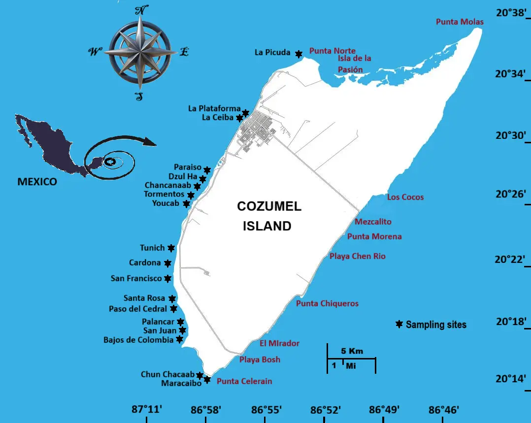
Cozumel is Mexico’s largest carbonate island in the Caribbean Sea, located 19 km northwest of the Yucatan Peninsula, separated by the Yucatan Channel. It measures 48 km by 16 km, with an average altitude of 5 m and coordinates 20°31′ N, 86°57′ W (Figure 1). The climate is warm and humid, with summer rainfall. The driest month receives less than 60 mm, and winter rainfall exceeds 10.2 mm [15].
The island of Cozumel formed during the Pleistocene era, specifically during the Wisconsin and Illinois transgressions. It is part of a mountain range that runs parallel to the coastlines of Belize and Quintana Roo [16,17,18,19]. On both sides, there is a narrow platform divided into terraces and steps. The western shelf has three terraces; the island slope begins 2 km from the coast. This slope has an almost vertical inclination of nearly 90° and reaches depths of about 400 m [9,20]. The edge of the shelf here is roughly at 500 m depth, with a nearby depth of around 20 m, gradually decreasing to 30 m or more toward the north and south [14,21]. The slope at this edge is gentle and consistent up to 50 m, then drops sharply outside the edge to depths exceeding 150 m. To the east of the island, there are up to five terraces, with the platform edge approximately 50 m deep. The island slope extends downward with interruptions to 1000 m [9]. On this side and to the south, the slopes plunge sharply to around 400 m, where they flatten, then fall again in the next step to depths of over 1000 m. In the Northeast ward, the shelf extends beyond 50 km but only reaches depths of about 50 m [8,22]. This shallow region continues toward the Arrowsmith Bank, 70 km from the island [23].
The tides reach a maximum of about 20 cm. The Caribbean Current flows between Cozumel and the mainland at speeds up to 4 knots (6.44 km/h), with variable strength throughout the year, especially on platform [24]. At the edge, the current is strong; along the west, countercurrents occur locally, such as in Paraíso and Chancanaab [25]. These currents align with prevailing winds; the north and east coasts usually face rough seas except in summer and autumn when westerly winds appear. The leeward coast is sheltered from large waves, except in autumn when strong north and northwest winds occur [26].
The water temperature remains almost constant throughout the year, with only a 2-degree difference between summer and winter (30 °C to 28 °C) [27]. Most of Cozumel’s reefs are in the southwest part of the island; they are extremely dense due to ocean circulation conditions. Cozumel is fortunate to have very close edge reefs on both coasts, making it one of the few Caribbean islands that offers excellent diving opportunities across a wide range of locations.
2.2. Sampling
From September 2020 to August 2023, records were collected from the most significant and most visited reefs by tourism, at different depths on 18 reefs on the western side of the island. The sampling frequency varied in both years due to resource availability. In each reef, parallel to the coastline and at depth intervals of 1–50 m, 20 m-long photographic transects [28,29] were done every 10 m. The samples consisted of photographs taken 80 cm above the bottom, every 50 cm along the transect, covering an area of 1904 cm2 (56 cm × 34 cm). Photographs were taken with a Nikonos V camera(Nikon, Sendai, Japan), placed perpendicularly to the reef floor and 80 cm above it. Records and interpretations were made to the highest possible taxonomic level, typically at the species level. All photographic samples were digitized using a Microtek Scanmaker 1850 transparency scanner(Microtek, Shenzhen, China) and then incorporated into the image analysis program (IMAT V. 5), which defined seven axes for each species analysed and automatically determined each species’ coverage. In this study, 9981 photographs were analysed. The coverages obtained were standardized to 1 m2 (coverage was multiplied by 5.25 as a standardization factor) across all sites.
In addition to these records, specific collections of certain organisms were made to verify their identities through taxonomic identification, based on descriptions of the morphological structures relevant to each group. For sponges, Colin [30], Voss [31], and Sefton and Webster [32] were followed; for gorgonaceans, Bayer [33]; for scleractinian corals, Fenner [8], Von Prahl and Erhardt [34], for macroalgae, Taylor [35], Huerta [11], and Mateo and Mendoza [12]; and for sporadic groups, field guides by Kaplan [36] and Humann [37] were used.
2.3. Analysis
The data were analyzed to assess the abundance, richness, and diversity (Shannon-Wiener) of each group at various sites. An XYZ matrix was then constructed, with the first two axes indicating the geographical location of each site, and the z-axis representing the magnitude of attributes such as species richness and diversity for each group. This enabled the creation of maps that depict the spatial distribution of these attributes. The maps were generated using SURFER V. 7 with the kriging method and a linear variogram, with interpolation validated through cross-validation. Subsequently, each GIS layer was developed using ARC/INFO to build a comprehensive scenario of protected areas, emphasizing species richness and diversity within the groups studied. The intersection tool was employed because it maintains the attributes of overlapping entities. These descriptors are frequently used in the design of Protected Natural Areas.
3. Results
3.1. Species Richness
The patterns of the groups analysed are presented in Figure 2.
Macroalgae. It has an area of great richness to the north of the island at the La Picuda site, which decreases towards the central zone and then gradually increases towards the south in Santa Rosa and Paso del Cedral, but without reaching the values of the northern area (Figure 2a).
Stony corals. For corals, there are nodules with high richness in part of the southern zone (Palancar, San Juan, and Bajos de Colombia), and a reduced nodule in the northern part that joins La Plataforma and La Ceiba, the other sites are in intermediate values between 9 and 12 species (Figure 2b).
Soft corals. They have a nodule of high value in the south (Bajos de Colombia and Chunchaka’ab), slightly more displaced in that direction than that obtained with corals. It also shows an area of medium values in the middle part of the island with a high-value nodule in Tunich (Figure 2c).
Sponges. The sponges show areas of high value in the middle part of the coast with nodules in La Plataforma and La Ceiba and in Dzul-Ha-Chankana’ab and Tunich; it is also the group with the largest number of species recorded with this methodology. The southern tip, Chunchaka’ab, and Maracaibo are the sites with the least richness (Figure 2d).
Fire Corals. The pattern identifies nuclei of high values in the northern (La Picuda and La Plataforma) and southern (Santa Rosa and Paso del Cedral) areas, while the middle part is an area with very low values (Figure 2e).
Anemones. Anemones have a pattern like algae, with areas of high value in the northern zone (La Picuda) and intermediate values in the central zone, even though there are high nodules that combine pairs of sites, as is the case of La plataforma-La Ceiba; Paraíso-Dzul-Ha; Tormentos-Youcab and Tunich-Cardona. This group shows a total absence in the southern zone (Figure 2f).
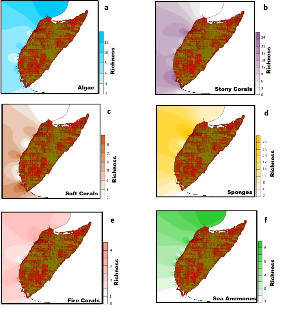
Figure 2. Species richness patterns of the six most representative reef groups in the phototransects. (a) Algae; (b) Hard corals; (c) Soft corals; (d) Sponges; (e) Fire corals; (f) Anemones.
3.2. Diversity
The diversity patterns obtained with the different groups are presented in Figure 3.
Macroalgae. This group has an interval ranging from 0.2 to 2.6 bits/ind, its highest values are present in the northern part and in a nodule that includes Santa Rosa, Paso del Cedral, Palancar, and San Juan at the beginning of the southern part. Its pattern is very similar to that of species richness (Figure 3a).
Hard corals. The pattern shown by the coral group involves the entire lower middle and the southern zone as areas of maximum values in an interval of (0.8 to 3.6 bits/ind). The northern zone is the one with the lowest values, except for two high-H’ nodules in the Platform and the Ceiba and in Dzul-Ha-Chankana’ab (Figure 3b).
Soft corals. They also show a high-value area in Chankana’ab and Maracaibo in the south, and a small nodule of high diversity in the middle part in Tunich. The diversity range ranges from absence in some sites (0) to 2.1 bits/ind (Figure 3c).
Sponges. This group shows high values in the upper middle part (La Plataforma and La Ceiba) and low values in the middle and southern zone, except for a nodule between Tunich and Cardona. The diversity recorded in this group ranges from 1.4 to 3.8 bits/ind, with values higher than those of other groups (Figure 3d).
Hydrozoans. Fire Corlas have high values in nodules that involve one site, as in Cardona, or two sites, as is the case of San Juan and Bajos de Colombia. Spatially, they are positioned in the lower middle, south (Chankana’ab), and upper middle part (La Plataforma). Its diversity range is from 0 to 1.5 bits/ind (Figure 3e).
Anemones. This group shows values from the lower middle part, presenting high values of diversity arranged in nodules in the middle zone (Cardona, Youcab, and Tormentos) and in the upper middle zone (La Ceiba). The diversity range recorded ranges from 0 to 0.7 bits/ind (Figure 3f).
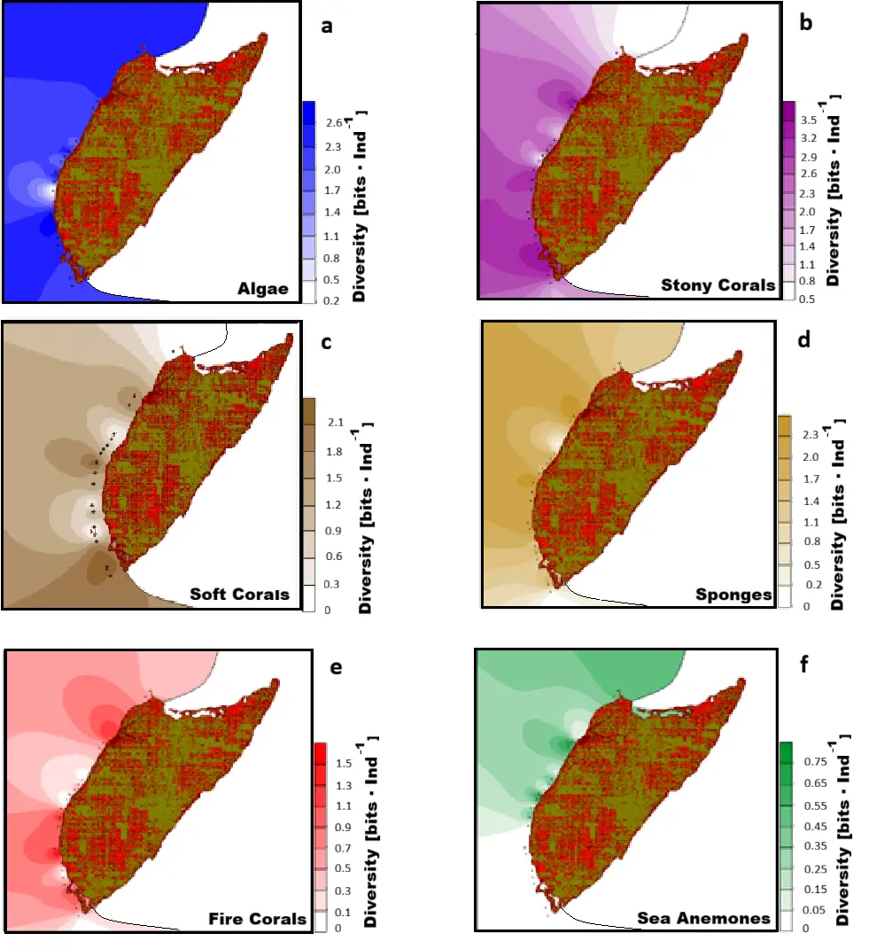
Figure 3. Diversity patterns of the six most representative reef groups in the phototransects. (a) Algae; (b) Hard corals; (c) Soft corals; (d) Sponges; (e) Fire corals; (f) Anemones.
3.3. Reef Zones
The zoning presented by the NMP recognizes 4 reef zones (INE, 1998): Restricted use, which includes the reef zone from the Islet, Punta Celerain, Maracaibo, Chunchaka’ab, Punta Sur and Colombia; Use of Low Intensity (East Polygon) on all East Coast reefs; Low Intensity Use (West Polygon), Paso del Cedral, La Francesa, Dalila and Palancar and an Intensive Use Zone, which includes Paraíso, Dzul-Ha, Las Palmas, Chankana’ab, Tormentos, Yucab, Tunich, Cardona, San Francisco and Santa Rosa (Figure 4a).
The scenario presented with the topological overlap of the species richness of the different groups shows nodules of high values in the upper middle zone (La Plataforma and La Ceiba), in the central zone (San Francisco), and in the southern zone (Palancar) (Figure 4b).
The map resulting from the superposition of diversities shows high-value nodules in La Picuda to the north, Chankana’ab, Tormentos, and Youcab in the middle part; San Francisco and Santa Rosa in the lower middle part, and Palancar and San Juan in the southern area (Figure 4c).
Both maps show an integral scenario with high values in the Platform, Tunich, Santa Rosa, Paso del Cedral, and Chunchaka’ab.
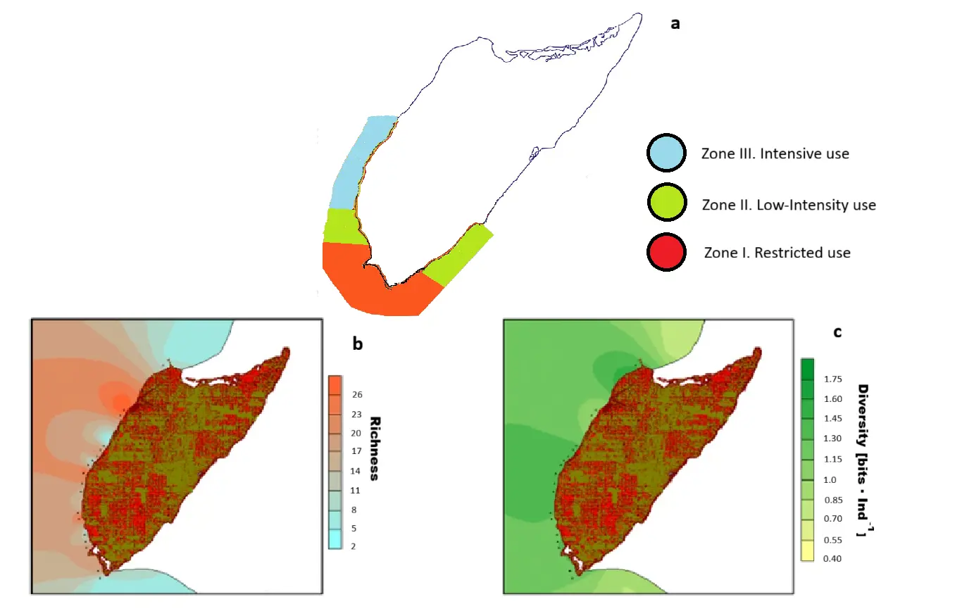
Figure 4. Zoning in the Cozumel Reefs National Park (PMN). (a) Use zones defined by the PMN, (b) Zones obtained with the species richness of the 6 groups analysed, (c) Zones obtained with the species diversity of the 6 groups analysed.
4. Discussion
In all of them, free and autonomous diving is permitted, with limits on space and time for experience, instruction levels, and buoyancy control; ecotourism; mechanically propelled vessels measuring less than 20 m in length, with a 2-m draft and a maximum capacity of 60 passengers; and commercial fishing according to bans, catch quotas, and fishing gear regulations, except in the last two areas where any fishing is prohibited [7]. According to this study, the middle southern and southern regions are the areas with the greatest richness and diversity of species (Figure 4a,b); However, interestingly, these are the areas that the NMP has classified as low-intensity and high-use zones, where only anchoring activities, boat navigation over 2 m draft, fishing, and jet ski use are prohibited. In both zones, daytime and nighttime diving, as well as wreck sinking and artificial reef construction, are permitted [7].
The park’s policy aims to develop diving activities, with approximately 1500 divers per day, averaging one or two dives [7,38]. However, due to the complexity observed in these areas, a more detailed analysis of the timing is recommended to determine if they are truly the best areas for this activity. The Management Program has identified the reefs of Paraíso, Chankana’ab, Paso del Cedral, and Palancar as the most visited for diving. Tourism has access to all the reefs, so its influence extends throughout the area. Although diving impacts reef organisms in various ways depending on the diver’s experience, boat traffic for transporting users is very high. Conserving and optimizing this activity is crucial to the local economy, as it is closely tied to many other productive activities in the area.
Other factors, both natural and human-related, have been mentioned above [39,40] that can significantly influence the structural complexity of the reef system, and they require national and international regulations to protect this NMP [41,42,43,44].
From the perspective that Isla Cozumel is a reef system of great significance for the reefs of the Mexican Atlantic, and using the same sampling method, Table 1 compares it with seven marine protected areas and an ocean system least impacted by human activities (Campeche Reefs). The comparison is based on the total species richness of the analyzed groups (Table 1). Macroalgae were included despite many being present and abundant only seasonally; they are a group that strongly competes for space with other reef groups, making them a key factor in the patterns of abundance and diversity in the area. This comparison highlights the importance of the faunal and floristic richness of the NMP Arrecifes de Cozumel reefs within the Mexican Atlantic.
Table 1. Comparison of species richness (%) of the groups analyzed in 6 NPAs and an Oceanic Reef System of the Gulf of Mexico (Campeche Reefs).
|
Protected Natural Areas |
Groups |
|||||||
|---|---|---|---|---|---|---|---|---|
|
Corals |
Gorgonids |
Hydrozoans |
Anemones |
Sponges |
Polychaetes |
Echinoderms |
Macroalgae |
|
|
Isla Mujeres, Nizuc, Cancun |
4.65 |
9.7 |
16.67 |
6.65 |
6.52 |
33.33 |
0 |
9.74 |
|
Isla Contoy |
5.86 |
5.8 |
11.11 |
7.74 |
1.46 |
8.33 |
0 |
5.84 |
|
Campeche Reefs |
12.94 |
14.25 |
11.11 |
12.79 |
13.77 |
25 |
0 |
9.74 |
|
Alacranes Reef |
11.47 |
9.73 |
11.11 |
10.49 |
13.04 |
8.33 |
0 |
6.49 |
|
Tulum |
2.56 |
8.4 |
5.56 |
2.06 |
0 |
0 |
0 |
0.65 |
|
Chinchorro Bank |
32.25 |
23.29 |
11.11 |
33.07 |
21.01 |
8.33 |
40 |
27.28 |
|
Puerto Morelos |
10.47 |
8.4 |
11.11 |
10 |
3.62 |
0 |
0 |
11.69 |
|
Cozumel Island |
19.8 |
20.43 |
22.22 |
17.2 |
40.58 |
16.68 |
60 |
28.57 |
Although this work mainly emphasizes spatial aspects, the areas it defines are precise and based on data collected from key groups within the reef zones, covering a depth range from 0.5 m to 50 m. Including temporal information would greatly enhance the understanding of these areas, especially for guiding conservation priorities. Additionally, with a comprehensive data set, it would be possible to develop well-informed zoning and use plans tailored to each area’s specific features. This study should serve as a foundation for more detailed research into critical habitats of individual species or groups with high diversity and abundance. Such research would help establish evaluation actions that balance environmental stability, sustainable use, and resource management. Depending on what is learned from temporal data, adjustments to area use could be implemented. If diving remains the primary activity and given its international recognition as a top sport diving destination, exploring options such as area rotation could help ensure some recovery in zones with high biodiversity.
5. Conclusions
-
-
Cozumel Island is very important for the reefs of the Mexican Atlantic, not only for its great biodiversity but also for the ecosystem services it provides, but above all because it is a pillar in the economy of the locals.
-
-
The diversity of groups is one of the highest of the reefs in that region.
-
-
If these services are to be maintained, it is necessary to re-evaluate the conditions for defining restricted and user zones, under criteria that consider the biodiversity of the groups that make up the reef ecosystem.
Acknowledgments
The author wishes to acknowledge Alicia González-Solis for her comments on the manuscript and the entire team at the Coral Reef Functional Groups Laboratory and its students for their support during the various field campaigns.
Ethics Statement
Not applicable.
Informed Consent Statement
Not applicable.
Data Availability Statement
The data in this manuscript were obtained from the Laboratory of Functional Groups in Coral Reefs of the Center for Research and Advanced Studies of the IPN. Unit Merida. And they are available upon request.
Funding
This research received no external funding.
Declaration of Competing Interest
The author declares that he has no known competing financial interests or personal relationships that could have appeared to influence the work reported in this paper.
References
- Ayuntamiento de Cozumel. Cozumel Cierra 2025 con Resultados Históricos en Turismo y Consolida su Liderazgo como Destino Integral. 2026. Available online: https://cozumel.gob.mx/prensa/cozumel-cierra-2025-con-resultados-historicos-en-turismo-y-consolida-su-liderazgo-como-destino-integral/ (accessed on 5 january 2026).
- Palafox-Muñoz A, Zizumbo Villarreal L. Territorial distribution and tourism in Cozumel, State of Quintana Roo, Mexico. Tour. Manag. 2009, 11, 69–88. DOI:10.4206/gest.tur.2009.n11-04 [Google Scholar]
- Torruco D, González-Solis A, Torruco-González AD. Large-Scale and Long-Term distribution of corals in the Gulf of Mexico and Caribbean Sea of Mexico and adjacent areas. Reg. Stud. Mar. Sci. 2021, 44, 101764. DOI:10.1016/j.rsma.2021.101764 [Google Scholar]
- Palafox-Muñoz A, Rubí-González F. The Challenges of Cruise Tourism in Cozumel, Mexico. Le tourisme de croisière: Défis et perspectives. Etudes Caribbeennes 2020, 47, 1–15. DOI:10.4000/etudescaribeennes.20118 [Google Scholar]
- Segrado-Pavón G, Arroyo-Arcos L, Amador-Soriano K, Farmer F. Motivational factors for tourist who choose Cozumel, Mexico, as a holiday destination in low seasons. El Periplo Sustentable 2017, 7, 3. Available online: https://www.scielo.org.mx/scielo.php?pid=S1870-90362017000100007&script=sci_arttext (accessed on 21 September 2025).
- DOF (Official Gazette of the Federation). Decree of the National Marine Park “Arrecifes de Cozumel”; Mexico Gob: Mexico City, Mexico, 1996. [Google Scholar]
- INE. Management Program of the National Marine Park “Arrecifes de Cozumel”; National Institute of Ecology: Mexico City, Mexico, 1998. [Google Scholar]
- Fenner DP. Some leeward reefs and corals of Cozumel, Mexico. Bull. Sea. Sci. 1988, 42, 133–144. Available online: https://www.ingentaconnect.com/content/umrsmas/bullmar/1988/00000042/00000001/art00008 (accessed on 14 October 2025).
- Muckelbahuer G. The shelf of Cozumel, Mexico. Topography and organisms. Facies 1990, 23, 201–239. DOI:10.1007/BF02536713 [Google Scholar]
- Boyd DW, Kornicker LS, Rezak R. Coralline algae microatolls near Cozumel Island, Mexico. Rocky Mt. Geol. 1963, 2, 105–108. Available online: https://pubs.geoscienceworld.org/uwyo/rmg/article-abstract/2/2/105/110665 (accessed on 30 July 2025).
- Huerta L. Contribution to the Knowledge of the Algae of the Lowlands of Campeche, Cozumel and Isla Mujeres. Annals National School of Biological Sciences, IPN. 1958, Volume 65, pp. 446–454. Available online: https://biblat.unam.mx/hevila/AnalesdelaEscuelaNacionaldeCienciasBiologicas/1958/vol9/no1-4/11.pdf (accessed on 30 July 2025).
- Mateo-Cid LE, Mendoza AC. Bentic seaweed from Cozumel Island, Quintana Roo, Mexico. Acta Bot. Mex. 1991, 16, 57–87. DOI:10.21829/abm16.1991.62 [Google Scholar]
- Kenyon J. Black corals off Cozumel. Sea Front. 1984, 30, 267–277. Available online: https://www.researchgate.net/publication/326178282_Assessing_population_changes_of_historically_overexploited_black_corals_Order_Antipatharia_in_Cozumel_Mexico(accessed on 30 July 2025).
- González-Solis MA, Torruco D, Torruco-González AD. Distribution and diversity of actinarians in protected natural areas: Alacranes and Cozumel Reefs. Science 2017, 25, 6–14. Available online: https://www.produccioncientificaluz.org/index.php/ciencia/article/view/22615 (accessed on 30 July 2025).
- Frausto-Martínez O, Zapi-Salazar NA, Colin-Olivares O. Identification of Karst Forms Using LiDAR Technology: Cozumel Island, Mexico; IntechOpen: London, UK, 2019. DOI:10.5772/intechopen.79196 [Google Scholar]
- Ward WC. Geology of coastal island, northeastern Yucatan Peninsula. In Developments in Sedimentology; Vacher HL, Quinn TM, Eds.; Elsevier: Amsterdam, The Netherlands, 1997; pp. 275–298. [Google Scholar]
- Spaw RH. Late pleistocene carbonate bank deposition: Cozumel Island, Quintana Roo, Mexico. Gulf Coast Asoc. Geol. Soc. Trans. 1978, 28, 601–619. Available online: https://archives.datapages.com/data/gcags/data/028/028001/0601.htm (accessed on 17 September 2025).
- Salgado-Garrido HE, Valera-Fernández D, Solleiro-Rebolledo E, Barragán R, Trejo-Pelayo S, Yáñez-Mendoza G, et al. The microfacies distribution pattern of Cozumel Island in southeastern Mexico: An atoll-like model led by quaternary glacioeustatic sea-level changes. J. South Am. Earth Sci. 2022, 118, 103933. DOI:10.1016/j.jsames.2022.103933 [Google Scholar]
- Gischler E, Lomando AJ. Isolated carbonate platform of Belize, Central America: Sedimentary facies, late Quaternary history and controlling factors. Geol. Soc. Lond. Spec. Publ. 2000, 178, 135–146. DOI:10.1144/GSL.SP.2000.178.01.10 [Google Scholar]
- Steidle SD, Warken SF, Schorndorf N, Förstel J, Schöder-Ritzrau A, Moseley G, et al. Reconstruction of Middle to Late Quaternary sea level using submerged speleothem from the northeastern Yucat’an Peninsula. J. Quat. Sci. 2021, 36, 1190–1200. DOI:10.1002/jqs.3365 [Google Scholar]
- Simms A. Last interglacial sea levels within the Gulf of Mexico and northwestern Caribbean Sea. Earth Syst. Sci. Data 2021, 13, 1419–1439. DOI:10.5194/essd-13-1419-2021 [Google Scholar]
- Isaack A, Gischler E. The significance of sand aprons in Holocene atolls and carbonate platforms. Carbonates Evaporites 2017, 32, 13–25. DOI:10.1007/s13146-015-0268-Z [Google Scholar]
- Torruco D. Fauna and Ecology of Scleractinian Corals in the Coral Reefs of Southeastern Mexico. Ph.D. Dissertation, The University of Barcelona, Barcelona, Spain, 1995. [Google Scholar]
- Athie G, Candela J, Sheinbaum J, Badan A, Ochoa J. Yucatan Current variability through the Cozumel and Yucatan channels. Mar. Sci. 2011, 37, 471–492. DOI:10.7773/cm.v37i4A.1794 [Google Scholar]
- Alcérreca-Huerta JC, Encarnacion JI, Ordoñez-Sánchez S, Callejas-Jiménez M, Barroso GGD, Allmark M, et al. Energy yield assessment from ocean currents in the insular shelf of Cozumel Island. J. Mar. Sci. Eng. 2019, 7, 147. DOI:10.3390/jmse7050147 [Google Scholar]
- Uchupi E. Eastern Yucatan continental margin and Western Caribbean tectonics. AAPG Bull. 1973, 57, 1075–1085. DOI:10.1306/83D90E58-16C7-11D7-8645000102C1865D [Google Scholar]
- Cabadas-Báez H, Solleiro-Rebolledo E, Sedov S, Pi-Puig T, Gama Castro J. Pedosediments of karstic sinkholes in the eolianites of N.E. Yucatán: A record of Late Quaternary soil development, geomorphic processes, and landscape stability. Geomorphology 2010, 122, 323–337. DOI:10.1016/j.geomorph.2010.03.002 [Google Scholar]
- Ohlhorst SL, Liddell WD, Taylor RJ, Taylor JM. Evaluation of reef census techniques. Proc. 6th. Int. Coral Reef Symp. 1988, 2, 319–324. Available online: https://digitalcommons.usu.edu/geology_facpub/368/ (accessed on 21 July 2025).
- Torruco D, González-Solis MA. Chinchorro Bank ecological basis for management and conservation of a reef system in the Mexican Caribbean. In Proceedings of the 8th International Coral Reef Symposium (ICRS), Panama City, Panama, 24–29 June 1996; p. 197. Available online: https://proceedings.gcfi.org/wp-content/uploads/2015/01/gcfi_53-17.pdf (accessed on 21 July 2025).
- Colin PL. Caribbean Reef Invertebrates; T.F.H. Publications: Neptune City, NJ, USA, 1988; p. 512. [Google Scholar]
- Voss GL. Seashore Life in Florida and the Caribbean; Banyan Books: Miami, FL, USA, 1980. [Google Scholar]
- Sefton N, Webster SK. A Field Guide to Caribbean Reef Invertebrates; Sea Challengers: Monterey, CA, USA, 1986. [Google Scholar]
- Bayer FM. The Shallow-Water Octocorallia of the West Indian Region. A Manual for Marine Biologists; The Hague Martinus Nijhoff: The Hague, The Netherlands, 1961. [Google Scholar]
- Von Prahl H, Erhardt H. Corals and Coral Reefs; Universidad del Valle, Ed.; Presencia Ltd.: Bogotá, Colombia, 1985. [Google Scholar]
- Taylor WR. Marine Algae of the Eastern Tropical and Subtropical Coasts of American; The University of Michigan Press: Ann Arbor, MI, USA, 1960; p. 840. [Google Scholar]
- Kaplan H. A Filed Guide to Coral Reefs: Caribbean and Florida (Peterson Field Guides); Houghton Mifflin Co.: Boston, MA, USA, 1982. [Google Scholar]
- Humann P, Deloach N. Reef Coral Identification: Florida, Caribbean, Bahamas: Including Marine Plants; New World Publications: Jacksonville, FL, USA, 1993. [Google Scholar]
- Lara-Pulido JA, Mojica Á, Bruner A, Guevara-Sanginés A, Simon C, Vásquez-Lavin F, et al. A business case for marine protected areas: Economic valuation of the reef attributes of Cozumel island. Sustainability 2021, 13, 4307. DOI:10.3390/su13084307 [Google Scholar]
- Cázares G. Qualitative and Quantitative Study of Scleractinian Corals (Anthozoa: Scleractinia) from the Paraiso and Chankana’ab Reefs, Cozumel, Quintana Roo, Mexico. Master Disertation, Universidad Autónoma de Nuevo León, San Nicolás de los Garza, Mexico, 1985. [Google Scholar]
- Alvarez-Filip L, Gill JA, Dulvy NK, Perry AL, Watkinson AR, Côte IM. Drivers of region-wide declines in architectural complexity on Caribbean reefs. Coral Reefs 2011, 30, 1051–1060. DOI 10.1007/s00338-011-0795-6 [Google Scholar]
- Schutte VGW, Selig ER, Bruno JF. Regional spatio-temporal trends in Caribbean coral reef benthic communities. Mar. Ecol. Prog. Ser. 2010, 402, 115–122. DOI:10.3354/meps08438 [Google Scholar]
- Selig ER, Bruno JF. A global analysis of the effectiveness of marine protected areas in preventing coral loss. PLoS ONE 2010, 5, e9278. DOI:10.1371/journal.pone.0009278 [Google Scholar]
- Alvarez-Filip L, Côté IM, Gill JA, Watkinson AR, Dulvy NK. Region-wide temporal and spatial variation in Caribbean reef architecture: Is coral cover the whole story? Global Change Biol. 2011, 17, 2470–2477. DOI:10.1111/j.1365-2486.2010.02385.x [Google Scholar]
- Reyes-Bonilla H, Millet-Encalada M, Álvarez-Filip L. Community structure of scleractinian corals outside protected areas in Cozumel island, Mexico. Atoll Res. Bull. 2014, 600, 1–13. DOI:10.5479/si.00775630.601 [Google Scholar]