Found 17 results
Open Access
Article
30 January 2026Forecasting Forest Product Yields in China Based on a Random Forest Model: Interaction Between Climate Change and Socio-Economic Factors
This study presents a comprehensive projection of China’s forest product yield dynamics (encompassing commodity timber and logs) through 2100, employing an innovative integration of machine learning and economic modeling. We developed a hybrid analytical framework combining random forest algorithms with Cobb-Douglas production functions to assess multi-dimensional drivers, including climatic variables, socio-economic indicators, and demographic trends. Our multi-model validation demonstrated strong predictive performance (R2 are 0.86 and 0.92), particularly in quantifying climate-production interactions, with sensitivity analysis identifying surface downward shortwave radiation (RSDS), population density (POP), and mean annual temperature (MAT) as dominant predictors explaining 68% of yield variance. Future yields exhibited significant spatial and temporal variations under different SSP scenarios, especially under SSP126, where yields were more stable, and under SSP245 and SSP370, where yields showed a moderate increasing trend. The SSP585 shows higher fluctuations and a decreasing trend in yields due to climate change. Geospatial modeling uncovered critical regional disparities, suggesting potential production migration from traditional southern bases to north-eastern/northwestern frontiers under climate stress. The southern subtropical belt emerged as particularly vulnerable to thermal extremes and precipitation variability, while northern regions demonstrated greater climate resilience but require substantial silvicultural adaptation. These results provide a scientific basis for developing more precise forest management policies and sustainable development strategies to help meet the challenges posed by future demand for forest products and climate change.
Open Access
Review
30 December 2025Advances in Hydrology of Irrigation Districts in Cold Regions
Given the extreme complexity of systems, the strategic importance of water resources, and the high ecological vulnerability in cold-region irrigation districts (CRIDs), research on the hydrological processes in these areas represents not only an interdisciplinary scientific endeavor, but also a critical practical challenge with direct implications for food security, water security, ecological safety, and sustainable regional development in high-altitude and high-latitude regions. The evolution of this field has progressed from early phenomenon identification to mechanistic analysis and, more recently, to multi-process and multi-scale simulation frameworks. This paper provides a systematic review of hydrological processes in CRIDs. It first examines fundamental components such as precipitation, evaporation, snowmelt, and groundwater recharge, highlighting their distinct behaviors under the combined influence of freeze–thaw cycles and irrigation practices, and further discusses the interactions and coupling mechanisms among these processes. Irrigation not only alters soil moisture distribution and freeze–thaw dynamics but also, together with freeze–thaw processes, shapes the transient hydrological dynamics characteristics of water and energy transfer, thereby influencing system stability and agricultural productivity. Hydrological modeling has advanced from simplified empirical approaches to mechanistic frameworks that integrate multiple processes and scales, yet challenges remain in the representation of nonlinear freeze–thaw, the integration of irrigation management, and cross-scale consistency. Moreover, cold-region irrigation districts exhibit heightened sensitivity to extreme events, such as rapid snowmelt, severe droughts or heavy rainfall. Future research should deepen the integration of freeze–thaw mechanisms with crop models, advance multi-scale coupled simulations, enhance long-term monitoring and scenario analysis, and systematically incorporate water–carbon balance and ecological effects into hydrological assessments. These efforts will support sustainable management and precision regulation of water resources in cold-region irrigation districts.
Open Access
Perspective
24 December 2025Revisiting the Conservation Challenges of Wild Argali (Ovis ammon ammon L.) in the Altai Mountain-Steppe under Climate and Anthropogenic Pressures
The high-mountain steppes of South-eastern Altai are a valuable resource for pastoralism—almost the only possible type of economic activity in these places—and the conservation of near threatened species, such as the argali. Argali are the largest and most vulnerable wild sheep (Ovis ammon ammon L.), and are listed in the Red Data Book of the Russian Federation and on the IUCN Red List. The argali is also important in the food chain of another rare and protected species, the snow leopard. This paper presents the results of research into the productivity of argali’s high-mountain steppes habitation in various parts of the Sailugem Ridge, and assesses their pasture degradation. We predict how observed declining pasture productivity due to anthropogenic and climate pressure, as well as argali grazing, will threaten their survival. We propose special measures to reduce the impact of the argali population on the degradation of current pastures, while improving argali conservation in other areas of South-eastern Altai and adjacent territories where the species previously existed.
Open Access
Review
05 November 2025Mental Health Impacts Associated with Exposure to Climate-Sensitive Hazards in Pacific Island Countries: A Scoping Review
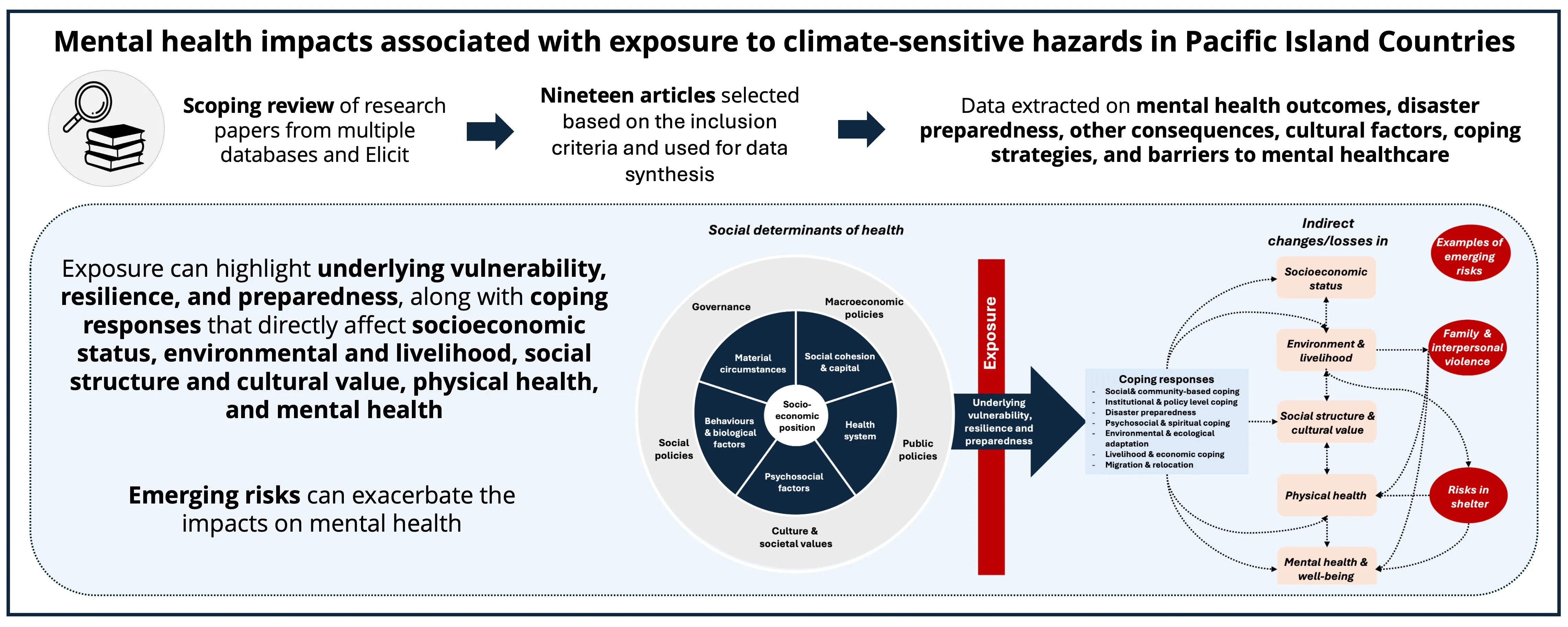
Pacific Island Countries (PICs) face some of the most severe health risks from climate change, with associated mental health impacts that remain under-recognized. This scoping review synthesizes peer-reviewed literature published by February 2025 to examine the mental health consequences of exposure to climate-related hazards across 22 PICs. The search identified 193 studies, 19 of which were included in the review. Most studies employed qualitative or mixed methods, focusing on storms, droughts, sea-level rise, planned relocation, and environmental changes. Reported mental health outcomes included increased depression, anxiety, grief, and distress, often linked to direct exposure and secondary effects such as displacement, resource insecurity, and social disruption. Risk and protective factors were identified, emphasizing broader social, cultural, spiritual, and environmental influences that mediate the relationships between climate-sensitive hazard exposures and mental health outcomes in PICs. Cultural mediators such as traditional knowledge, land connection, and community cohesion shaped both vulnerability and resilience. Common coping strategies included relocation, community-based support, and leadership-driven actions. However, access to mental healthcare remained limited due to a shortage of trained professionals, stigma, and preference for traditional healing methods. To address these challenges, it is essential to integrate mental health into national public health frameworks, enhance disaster preparedness, increase access to mental health services, and conduct context-specific research.
Open Access
Article
23 September 2025Promoting Sustainable Development through Community Education on Flood- and Storm-Resistant Architecture
Pakistan is experiencing climate-induced disasters such as floods and storms with an increased frequency and intensity every single year. This study aims to explore the integration of resilient architecture into environmental education as a pathway toward sustainable development and disaster risk reduction. The research examines current levels of understanding regarding flood- and storm-resistant building practices and identifies key barriers to their adoption in high-risk regions of Pakistan. The study used a mixed-methods approach by administering surveys. These surveys were administered to 500 community members in different cities of Sindh and Punjab. The study also incorporated two in-depth case studies: the Heritage Foundation’s low-cost housing initiative in Makli, Sindh, and the Aga Khan Agency for Habitat’s Safe Housing Program in Chitral, Khyber Pakhtunkhwa. These cases provide valuable insights into effective, culturally appropriate, and scalable models of resilient construction in Pakistan. Findings of the present study reveal that public awareness of resilient architecture is below a satisfactory level, with common misconceptions. Challenges, including high costs, lack of technical knowledge, and minimal government support, were identified as significant obstacles. Despite these issues, communities showed strong interest in learning about safer building practices when exposed to practical examples and local success stories. The study recommends integrating resilient construction education into community outreach, school curricula, and builder training programs. It also advocates for greater government involvement, financial incentives, and replication of proven models to foster widespread adoption of resilient architecture for long-term sustainability.
Open Access
Review
13 August 2025Allowing Space for Nature: Rewilding to Heal the Earth
The term “rewilding” often elicits strong emotions, especially as presented in the media. Thus, anger is provoked that farmers will be forced to waste precious cropland, letting it return to the wild, or from fear that dangerous animals will be released into the urban environment. With equal fervour, others, taking an approving view, comprise the growing movement of guerrilla rewilders, secretly breeding butterflies, birds and beavers, and illegally releasing them (e.g., “beaver bombing”) across the countryside. In truth, rewilding is a complex and widely encompassing proposition, which can be considered as a strategy within the natural climate solutions (NCS) [nature based solutions (NBS)] approach, aimed to restore and enhance wetlands, grasslands, forests, agricultural lands, seascapes etc. While exact definitions may vary, a key feature is that (after some initial support) it minimises the level of human intervention/management in a given region, instead encouraging natural processes to take the lead and self-manage, in the restoration, shaping and enhancement of natural ecosystems and of critical ecosystem functions. The resilience of such ecosystems should also be considered, especially in regard to how the impacts of a changing climate may prevail upon them. Rewilding is informed by science, traditional ecological knowledge (TEK), and other local (indigenous) knowledge. It is a long-term process with dynamic changes occurring over time, and rather than focussing on reaching a fixed endpoint, provides a continuous journey of letting nature’s processes unfold. This can lead to increased biodiversity, amelioration of and resistance to climate change, and the provision of ecosystem services, benefitting both nature and people, including economic opportunities for local and indigenous communities, along with improved overall health and well-being. Despite its manifold and clear benefits, rewilding (along with other NCS) is not a pancea for all our troubles, many of which are rooted in the systemic issue of human ecological overshoot, and it is this that must be addressed to begin fixing the current global polycrisis.
Open Access
Communication
22 July 2025The Importance of Methods in Assessing Conservation Status of Abundant Fish Species through Genetic Diversity Estimates
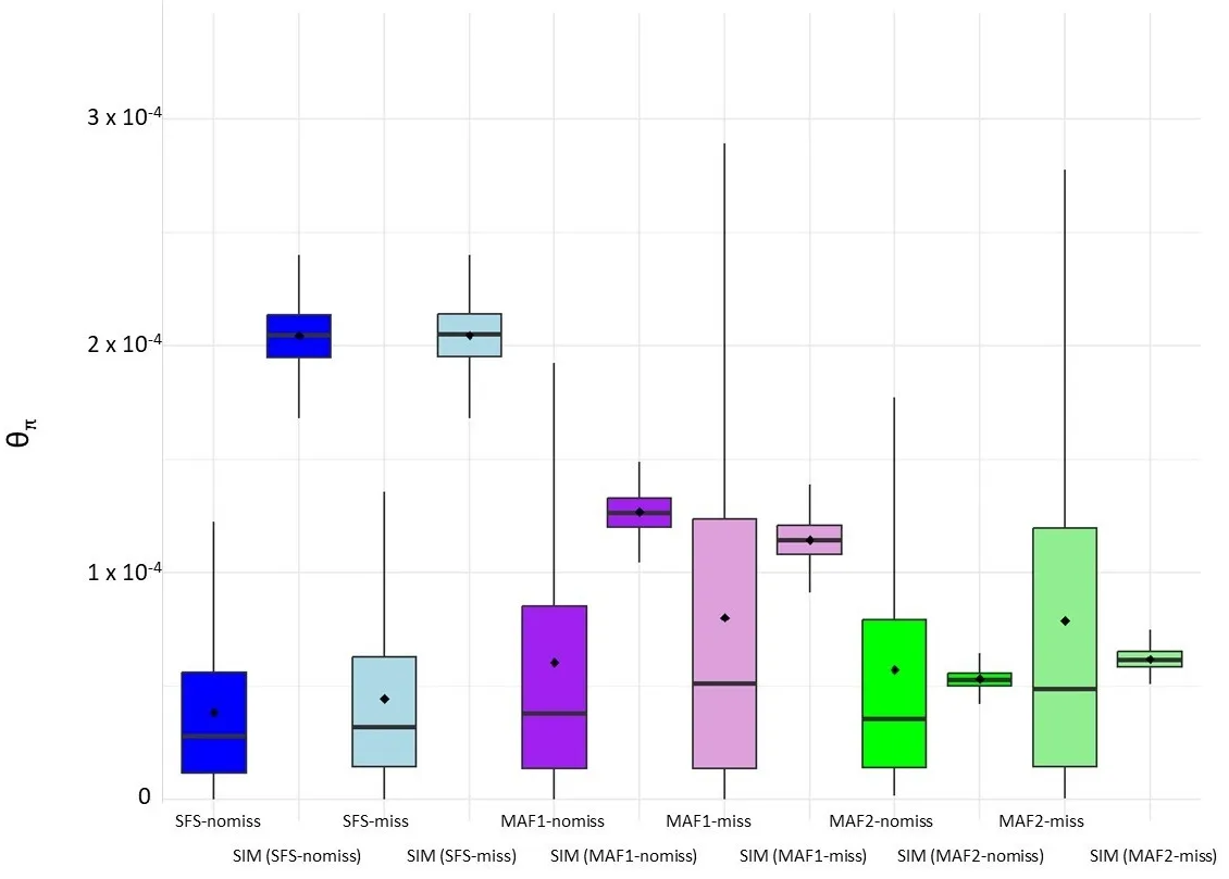
This study compares the accuracy of two genomic approaches in estimating genetic diversity levels, which could be useful for informing species conservation assessments of abundant, exploited fish species. The first approach (SNP-calling-based) is the commonly used pipeline of SNP calling followed by SNP filtering at a determined Minor Allele Frequency (MAF). The second approach (genotype-likelihood-based) does not perform SNP calling but estimates the Site Spectrum Frequency (SFS) based on alignment quality and sample size. The results show up to two-fold differences in the magnitude of the estimated nucleotide diversities among the analyzed datasets. The SNP-calling-based approach produces overestimates when missing data are considered in the analysis and shows pronounced deviations of the SFS towards high-frequency SNPs when filtering by MAF > 5%. The genotype likelihood-based approach showed that nucleotide diversity estimates significantly deviated from neutral expectations, as expected based on the known history of the case-study fish population analyzed here, regardless of whether missing data were considered. In contrast, the SNP-calling-based approach only shows this expected difference when no missing data are included and no MAF filtering is performed. Overall, the results indicate that using the SNP-calling-based approach may hide the effects of population size declines in abundant exploited fish species, while genotype-likelihood-based estimates of nucleotide diversity can effectively contribute to informing conservation assessments.
Open Access
Article
25 March 2025Integrated Habitat Assessment of a Protected Fish Species in the Upper Yangtze River, China: Connectivity and Suitability
In the context of anthropogenic climate change, dam construction, and other human activities, the biodiversity of freshwater fish is rapidly declining. The Upper Yangtze River Basin (UYRB) is a hotspot for hydropower development and is home to numerous endemic and rare freshwater fish species, most of which are on the brink of extinction. Schizothorax chongi is an endangered and protected fish species endemic to the UYRB, with significant economic and ecological value. However, the potential habitat of its wild population has not been reported, which hampers conservation efforts for this valuable species. This study utilized the Dendritic Connection Index (DCI) and Species Distribution Models (SDMs) to assess habitat connectivity in the UYRB and habitat suitability for S. chongi during the periods 1970–2000 and 2001–2020, respectively. The results show that S. chongi habitats underwent significant reduction during the 2001–2020 period, with the total length of medium and high suitability habitats decreasing by 51.7%. However, high suitability habitats in the southern section of the middle and lower Jinsha River, which is located in the upper and middle part of the UYRB, did not experience a noticeable reduction. Despite the relatively high habitat suitability maintained in the southern section of the middle and lower Jinsha River, connectivity has significantly declined. Restoring connectivity reduced by dam construction in this region is critically urgent. This study is the first to conduct a watershed-scale assessment of fish habitat integrating habitat suitability and connectivity providing valuable insights for local governments to develop specific conservation measures and plans. It can offer a valuable reference for researchers in the field of freshwater fish conservation.

Open Access
Article
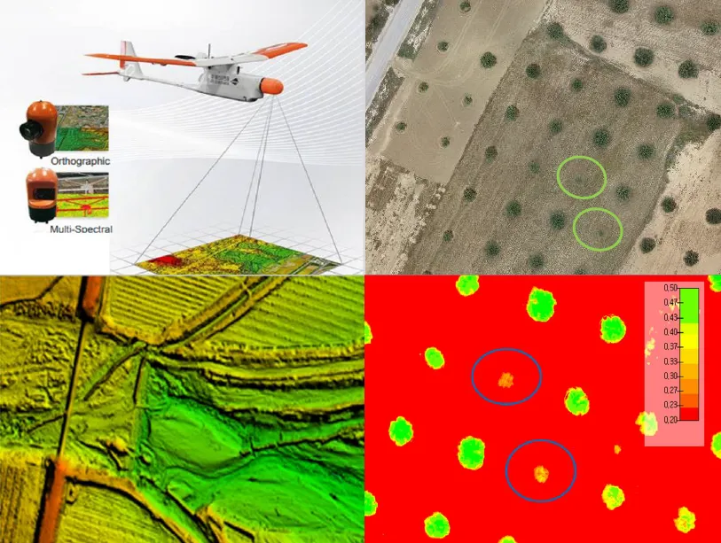
10 March 2025Leveraging Drone Technology for Precision Agriculture: A Comprehensive Case Study in Sidi Bouzid, Tunisia
The integration of drone technology in precision agriculture offers promising solutions for enhancing crop monitoring, optimizing resource management, and improving sustainability. This study investigates the application of UAV-based remote sensing in Sidi Bouzid, Tunisia, focusing on olive tree cultivation in a semi-arid environment. REMO-M professional drones equipped with RGB and multispectral sensors were deployed to collect high-resolution imagery, enabling advanced geospatial analysis. A comprehensive methodology was implemented, including precise flight planning, image processing, GIS-based mapping, and NDVI assessments to evaluate vegetation health. The results demonstrate the significant contribution of UAV imagery in generating accurate land use classifications, detecting plant health variations, and optimizing water resource distribution. NDVI analysis revealed clear distinctions in vegetation vigor, highlighting areas affected by water stress and nutrient deficiencies. Compared to traditional monitoring methods, drone-based assessments provided high spatial resolution and real-time data, facilitating early detection of agronomic issues. These findings underscore the pivotal role of UAV technology in advancing precision agriculture, particularly in semi-arid regions where climate variability poses challenges to sustainable farming. The study provides a replicable framework for integrating drone-based monitoring into agricultural decision-making, offering strategies to improve productivity, water efficiency, and environmental resilience. The research contributes to the growing body of knowledge on agricultural technology adoption in Tunisia and similar contexts, supporting data-driven approaches to climate-smart agriculture.
Open Access
Article
06 February 2025Performance Impacts of Rainwater Tanks on Stormwater Drainage Systems
This article explores the impact of using rainwater tanks on the performance of a stormwater drainage system and the possible challenges posed by climate change and future rainfall projections. This project examines a residential development in Aldinga, South Australia. The study sets clear research objectives that include the creation and simulation of drainage systems with different conditions (e.g., with and without rainwater tanks, historical data, and projected data). The aim is to analyze performance changes in the drainage network after the inclusion of rainwater tanks. Furthermore, the incorporation of projected rainfall data is considered to study possible implications of climate change on the system performance. The methodology follows a quantitative approach, with data collection, creating different models with the use of software, and simulating various conditions such as storms with different annual exceedance probabilities and varying proportions of roof area connected to rainwater tanks. Several findings are identified in this project. When roof areas of all residential allotments are connected to rainwater tanks, substantial benefits are observed in reducing peak flows within the network and runoff volumes. This proportion of connected roof area is directly correlated with reductions in peak flow. Also, while the use of projected rainfall data slightly affects benefits in peak flow and volume reduction, they will remain relatively high at least until 2050. Other performance features, such as hydraulic gradient line, long sections, and time to peak, are also explored. Study validates the hypothesis that rainwater tanks have a significant impact on runoff reductions and flood management, particularly when 100% of roof area is connected with rainwater tanks. Also, there is an impact when projected data is used, but it remains manageable and should be considered under specific contexts to decide whether these impacts are significant. Several opportunities for future research are suggested. These include the examination of larger areas, projections to a more distant future, the use of different rainfall patterns, and the consideration of extreme rainfall events.