Bioeconomy, Green Transition and Environmental Sustainability: The Roccamonfina Area in the Campania Region (Italy)

Bioeconomy, Green Transition and Environmental Sustainability: The Roccamonfina Area in the Campania Region (Italy)
Received: 04 December 2025 Revised: 29 December 2025 Accepted: 06 February 2026 Published: 06 March 2026

© 2026 The authors. This is an open access article under the Creative Commons Attribution 4.0 International License (https://creativecommons.org/licenses/by/4.0/).
1. Introduction
Italy is a country of modest size (302,073 km2, morphologically varied and fragile, characterised by a predominantly hilly terrain covering 41.6% of its total surface area [1], with a longitudinal Apennine ridge along which, in medieval times, communities settled in inhabited centers, now distant from the main communication routes and accessible by vehicle, with travel times exceeding 30 min. Most of these areas make up the Italian inland territory, which covers 3/5 of the entire national territory. Historically and densely populated, it is subject to widespread hydrogeological instability and requires targeted interventions and actions to protect local communities and heritage. Since 2013, the “National Strategy for Internal Areas” (SNAI, 2013) has classified these areas as internal areas [2]. In Southern Italy, 39% of peripheral and ultra-peripheral municipalities, 17% of the population, and 42.3% of the area have values above the national average (24.1%, 9% and 33.7% respectively) [3]. All the municipalities that make up the study area have been included in the list of municipalities in Internal Areas as part of the “National Strategy for Internal Areas”. Over the last ten years, analysis of the attractiveness of Italy’s internal areas, with reference to those in southern Italy, has highlighted how closely it is linked to the potential and characteristics of the bioeconomy. In this context, research on ecosystem services has focused not only on understanding and quantifying the services ecosystems provide for human well-being, but also on integrating them into land-use planning and management [4]. The ecosystem approach is one of the pillars of Italy’s National Biodiversity Strategy [5]. The latter includes a special section dedicated to the theme of “species, habitats and landscape”, which emphasises how joint action by the state, regions and local authorities must recognise the intrinsic value and importance, including economic importance, of the structure, functions, distribution and services provided by ecosystems. Ecosystem services, also used as a tool for analysing and assessing land consumption, are useful bases for land management that favour incentives for those who activate them [6,7,8,9]. In particular, the agri-food sector has undergone significant changes, leading to substantial transformations across many countries’ inland landscapes, first and foremost Italy. Within the agri-food sector, the relationships between production systems, producers, and consumption models are entirely new and constantly evolving [10]. The 2009 report by the International Assessment of Agricultural Knowledge, Science and Technology for Development [11], defines the food system as a complex network of interactive processes that determine food availability and nutritional quality within a community. At its core are food system activities that include production, processing, distribution, and consumption; these activities generate outputs in terms of social well-being, food security, and environmental quality. The demand for food quality explicitly refers to different modes of production and local development with a view to greater environmental sustainability and new ethical principles of choice. Over the last fifty years, however, there has been a profound change, with more pronounced effects in the most industrialized countries, with a shift from a local to a global dimension, from a traditional to an industrial system, from a state-regulated system to one monopolized by a small number of companies in a market where corporations control the entire supply chain, from production to distribution. The aim is to develop policies capable of striking a balance between the development prospects (in terms of balanced social and economic growth) of the territory and the need to protect biodiversity and natural capital. If we focus on the policies most directly related to the relationship between planning and biodiversity, one issue of particular interest is the role of protected areas. The last forty years have seen a process of profound change in Italy in the paradigms of the conception, management, and planning of parks and protected areas, together with issues related to the participation of local communities and topics connected with management aspects [12]. The Spring Cluster, active since 2014, is a benchmark for innovation in Italy’s circular bioeconomy. It brings together players from the academic, agricultural, industrial and institutional worlds to promote the development and industrialization of technologies based on biological resources, to facilitate the transition from a linear economy, based on the intensive use of fossil resources, to a circular bioeconomy, which makes use of renewable raw materials from the agricultural and forestry sectors and organic waste from urban areas [13]. In this context, the aim is to contribute to good practices to define a development model based on sustainable tourism that can identify and promote the specific characteristics of the area, contributing to the preservation of agricultural landscapes, facilitating the conversion and reuse of existing heritage, and encouraging the development of an offering that complements traditional tourism. In the protected natural areas of the Campania Region, which cover about 30% of the entire regional territory, tourism and everything that revolves around it have managed to create small, limited areas of economic growth and environmental protection supported by the notion of sustainable development that has been incorporated into the Constitution [14]. Sustainable territorial development models can facilitate mechanisms for lasting socio-economic growth that establish a new balance among the territory, communities, and agricultural production, while respecting biodiversity. The ultimate objective is to create better living conditions for local populations and ensure that inland areas of southern Italy also participate actively in the growth and sustainable development of the Italian economy. These premises form the basis for the reasons behind and the conduct of the research summarised in this paper.
2. Materials and Methods
The proposed method of analysis is territorialism [15], characterised by a multidisciplinary approach (with contributions from geologists, agronomists, wildlife experts, landscape architects, economists, and interviews with local administrators). Using tools, some of which are traditional, such as data analysis (socio-economic, demographic, and territorial statistics), field observations, meetings with local and district decision-makers, and analysis of municipal and territorial planning, the area is analysed considering physical, demographic, economic, social, and institutional data. Several similar cases have been taken from current literature and analysed, where participatory planning processes shared with local communities have achieved results that are considered useful, acceptable, and lasting. The aim is to understand the complexity of the situation and identify its potential and critical issues with the aim of supporting municipal and district decision-makers in their plans, programs, and intervention strategies to help pursue sustainable development. Presently, despite the Campania Region making significant investments to identify protected natural areas, which together cover approximately 30% of the regional surface area, the nine regional parks in Campania have not succeeded in creating the conditions for sustainable development so strongly advocated by Italian national law No. 391 of 1991 on protected natural areas. The main cause of this situation lies in the inability to draw up the protected area planning tool called the “Park Plan” and in the lack of involvement of local communities in the planning processes, which, in the case of protected areas, should be participatory and shared with local communities. If the analyses, considerations, and recommendations for the park in the area under study had been available, it would have been possible to start with the elements that emerged to draft this essay. The aim is to create detailed knowledge frameworks that can be used in the planning of effective interventions, land management, and spatial planning in general. The use of SWOT analysis to highlight the area’s potential, the critical issues, the opportunities contained largely in existing planning tools, and the critical issues of the territorial system studied allows us to summarize aspects that would otherwise require a great deal of space to illustrate. As specified, the analysis was conducted with a territorialism approach, and the swot analysis was developed considering the peculiarities of the chosen study area and the most significant determinants that represent it. Specifically, some of the elements of the Swot analysis were identified after careful analysis of municipal urban plans and possible development prospects for the area. The multi-disciplinary analysis was also developed to fill a gap in the existing literature on the chosen area and to provide diachronic insights into the development of the area and its fragilities.
2.1. The Study Area
From a methodological point of view, the choice of study area takes into account the specific characteristics identified by the National Strategy for Internal Areas (SNAI, 2013). Geographically, it is located in the north-western part of the Campania region, in the province of Caserta, on the border with the Lazio Region (Figure 1), whose administrative boundary coincides with the final stretch of the Garigliano River, while to the north it borders the Molise region. Within it, there is a protected natural area, namely the “Roccamonfina-Foce Garigliano Regional Park” [16]. The reference unit considered coincides with the “Rural Territorial System of the Garigliano Plain” [17], as reported and analysed in the “Campania Regional Territorial Plan”, as the proposed methodology uses reliable and acceptable analyses. From a morphological point of view, the area is formed by the Roccamonfina volcanic complex, which is the largest inactive volcano in Europe. There are thirteen municipal territories (Figure 1) which, from an administrative point of view, make up the area under study. The total area of the municipal territories is 582.64 km2 (about one-fifth of the provincial area), all of which belong, from an administrative point of view, to the province of Caserta.
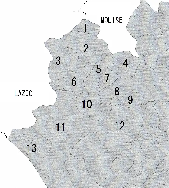
Figure 1. Municipalities in the Roccamonfina area in the province of Caserta in the Campania region, Italy. Legenda: 1 San Pietro Infine, 2 Mignano Monte Lungo, 3 Rocca d’Evandro, 4 Presenzano, 5 Conca della Campania, 6 Galluccio, 7 Tora e Piccilli, 8 Marzano Appio, 9 Caianello, 10 Roccamonfina, 11 Sessa Aurunca, 12 Teano, 13 Cellole.
Only the municipalities of Sessa Aurunca and Cellole have coastlines, which are popular destinations for summer beach tourism. The border with the Lazio region is marked by the final stretch of the Garigliano River, one of the most important rivers in southern Italy. The final stretch and mouth of the Liri-Garigliano River add value to the area by contributing to the protection of the biodiversity typical of wetlands. From the point of view of protecting the area, the Liri-Garigliano river is included in two Special Areas of Conservation of the European Natura 2000 Network, as well as in the Roccamonfina Regional Park and the Garigliano estuary area. It flows into the ancient Roman city of Minturnae, in Lazio, on the north bank, and the tourist resort of Baia Domizia on the south bank, crossed by the Via Appia, the “Regina Viarum” (Queen of Roads), which has recently been added to the list of World Heritage Sites and placed under the aegis of UNESCO [18].
2.2. Statistical and Demographic Data
Ten of the thirteen municipalities that make up the area have a population of less than 5000 inhabitants (Table 1), one has between 5000 and 10,000 inhabitants (Cellole), another has between 10,000 and 20,000 inhabitants (Teano), and only Sessa Aurunca has a population of just over 20,000 inhabitants and manages to be a reference point for the entire area. Overall, the total population of the entire Roccamonfina area is less than 60,000 inhabitants, having lost approximately 7000 inhabitants in just twenty years, i.e., more than 10% of the settled population. In the census years from 2001 to 2021, it can be seen that in the ten small municipalities with fewer than 5000 inhabitants, the population trend shows a significant percentage decrease in the municipalities of Tora e Piccilli and Marzano Appio; there is also a substantial decrease in the municipalities of San Pietro Infine, Conca della Campania, Presenzano, Galluccio, Mignano Monte Lungo, Rocca d’Evandro, Teano, and Sessa Aurunca. Only in the municipalities of Caianello, to an almost negligible extent (0.17%), and Cellole, to an extent of 13.11%, has there been an increase in the resident population (Table 1 and Figure 2), due to an immigration trend (Figure 3 and 4, Table 2 and 3).
Table 1. Population by Census years trends in the municipalities included in the Roccamonfina and Piana of the Garigliano area by Census years 2001, 2011, and 2021. Legenda: D = Variation in % years 2001–2011 and 2011–2021 [19].
|
Municipalities |
Population 2001 |
Population 2011 |
Population 2021 |
D 2011–2001 (%) |
D 2021–2011 (%) |
|---|---|---|---|---|---|
|
Tora e Piccilli |
1068 |
947 |
792 |
−12.78 |
−19.57 |
|
San Pietro Infine |
1011 |
949 |
859 |
−6.53 |
−10.48 |
|
Conca della Campania |
1392 |
1256 |
1165 |
−10.83 |
−7.81 |
|
Presenzano |
1741 |
1747 |
1658 |
0.34 |
−5.37 |
|
Caianello |
1758 |
1782 |
1761 |
1.35 |
−1.19 |
|
Marzano Appio |
3087 |
2345 |
2013 |
−31.64 |
−16.49 |
|
Galluccio |
2385 |
2239 |
2041 |
−6.52 |
−9.70 |
|
Mignano Monte Lungo |
3314 |
3258 |
2999 |
−1.72 |
−8.64 |
|
Rocca d’Evandro |
3720 |
3366 |
3042 |
−10.52 |
−10.65 |
|
Roccamonfina |
3807 |
3626 |
3206 |
−4.99 |
−13.10 |
|
Cellole |
7149 |
7684 |
8086 |
6.96 |
4.97 |
|
Teano |
13,042 |
12,587 |
11,445 |
−3.61 |
−9.98 |
|
Sessa Aurunca |
22,825 |
22,216 |
20,366 |
−2.74 |
−9.08 |
|
Totals |
66,299 |
64,002 |
59,433 |
−3.59 |
−7.69 |
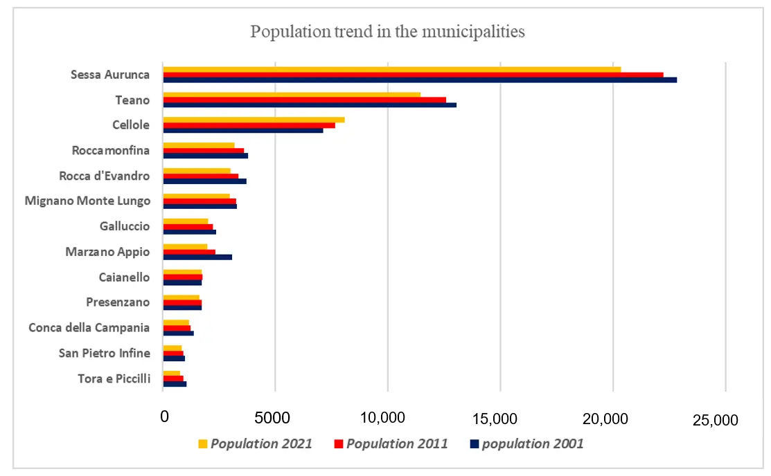
Figure 2. Population in thousands of trends in the municipalities included in the Roccamonfina and Piana of the Garigliano area by Census years 2001, 2011, and 2021.
Table 2. List of municipalities, territorial extension, density, and population in thousands (Source: https://www.istat.it/comunicato-territoriale/censimento-della-popolazione-dati-regionali-anno-2023/, accessed on 16 June 2025) [20].
|
Municipalities |
Municipal Area in km2 |
Density |
Population (30 June 2023) |
|---|---|---|---|
|
Tora e Piccilli |
12.39 |
60.86 |
754 |
|
San Pietro Infine |
13.72 |
59.91 |
822 |
|
Caianello |
15.68 |
113.01 |
1.772 |
|
Conca della Campania |
26.47 |
43.37 |
1.148 |
|
Marzano Appio |
28.3 |
69.82 |
1.976 |
|
Roccamonfina |
31.04 |
101.84 |
3.161 |
|
Presenzano |
31.89 |
50.74 |
1.618 |
|
Galluccio |
32.11 |
62.94 |
2.021 |
|
Cellole |
36.79 |
218.73 |
8.047 |
|
Rocca d’Evandro |
49.54 |
60.80 |
3.012 |
|
Mignano Monte Lungo |
53.10 |
56.16 |
2.982 |
|
Teano |
89.43 |
124.92 |
11.172 |
|
Sessa Aurunca |
162.18 |
124.30 |
20.159 |
|
Totals |
582.64 |
58.644 |
Table 3. Times, distances, and SNAI location of municipalities in the Roccamonfina area (source: https://politichecoesione.governo.it/media/3167/snai-dossier-regionale-campania.pdf [21]).
|
Municipalities |
Travel Times from Caserta in Minutes |
Distance in Kilometres from Caserta |
SNAI Classification |
|---|---|---|---|
|
Marzano Appio |
24 |
19.9 |
I |
|
Presenzano |
26 |
22.2 |
I |
|
Tora e Piccilli |
25 |
22.3 |
I |
|
Mignano Montelungo |
33 |
28.2 |
I |
|
Cellole |
34 |
28.6 |
I |
|
Teano |
36 |
32.7 |
I |
|
Galluccio |
40 |
33.6 |
P/I |
|
San Pietro Infine |
37 |
35.4 |
I |
|
Caianello |
35 |
40.9 |
I |
|
Rocca d’Evandro |
40 |
43.9 |
P |
|
Sessa Aurunca |
45 |
44.0 |
P |
|
Roccamonfina |
48 |
45.3 |
P |
|
Conca della Campania |
50 |
54.2 |
P |
Legend: I; it means intermediate internal area. P/I; it means internal area peripheral. P; it means peripheral.
The proximity of Cassino, a city in the Lazio region, guarantees access to essential services such as the local court, hospital, university, and numerous business services.
2.3. The Area of the Roccamonfina and Foce Garigliano Regional Nature Park, the Special Area of Conservation (SAC), and the Special Protection Area (SPA)
For about 30 years, the Campania Region has been establishing protected natural areas at both regional and national levels, identifying nine parks and four nature reserves, in addition to those established since 1991, namely the Vesuvius National Park (7259 ha) and the Cilento, Vallo di Diano, and Alburni National Park (181,048 ha). The “Roccamonfina and Foce Garigliano Regional Park” is one of the nine regional parks in Campania, definitively established in 2002 and occupying the northern part of the province of Caserta on the border with the Lazio Region. The park covers an area of 8705 ha [22]. The total area of the municipal territories that contribute to the protected natural area amounts to 38,183 hectares. The park extends over the Roccamonfina volcanic complex, which is older than Vesuvius and consists of an outer crater ring with an average width of 6 km, defined at its highest points by Monte Santa Croce (1005 m) and Monte Làttani (810 m) and by several volcanic cones with a hemispherical dome profile, such as Monte Atano (Casi-Teano), Colle Friello (Conca della Campania), and Monte Ofelio (Sessa Aurunca). The area is bordered to the north-west by the Garigliano river, to the north-east by the Monte Cesima mountain range, and to the south-east by the Massico mountain range. The municipalities that contribute part of their territories to form the protected area of the Park are: Sessa Aurunca, Teano, Roccamonfina, for their entire territory, Marzano Appio, Conca della Campania, Galluccio, and Tora e Piccilli, the latter also part of the “Monte Santa Croce” mountain community [23].
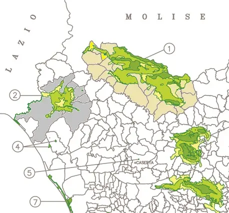
Figure 4. Number 1 corresponds to the Matese regional park. The Park area is divided into three zones: dark green indicates a greater degree of environmental protection, lighter green indicates an intermediate level of protection, while the deep yellow zone indicates a low level of environmental protection. All the territories that contribute to the definition of the park area have been fielded with the light ochre colour. Study area, including all municipal territories (area shaded in grey) and the Roccamonfina-Foce Garigliano Regional Park (shaded in shades of green), and identified with the number 2 in a circle.
The Roccamonfina Volcano (1006 m above sea level) is the oldest in the Campania region and the fourth largest in Italy. Another important form of nature protection is the Natura 2000 programme. This involves the whole of Europe, and all member states of the European Union launched in 1995. The park area also includes a Special Area of Conservation (SAC) called Vulcano di Roccamonfina, identified as part of the European Natura 2000 protection network with the code IT8010022 [24]. The areas concerned with biodiversity conservation fall within the park area shown in Table 4. The mountains of Mignano Montelungo are a Special Area of Conservation (SAC) designated in the Habitats Directive. They cover the territories of Galluccio, Mignano Monte Lungo, and Rocca d’Evandro and are characterised by limestone hills and large areas of mixed woodland with xerophilous grasslands and fragments of Mediterranean scrubland degraded by fire [25]. The Site of Community Interest “Pineta della Foce del Garigliano” [26,27] and a habitat of Community importance (Natura 2000 code: 9260—Castanea sativa forests) [28] constitute other areas of environmental value. To complete the picture of outstanding natural features, where biodiversity is preserved, five wilderness areas have also been identified, established, and protected, which best illustrate and characterise this inland area, with corners that are still almost untouched [29,30,31].
Table 4. Special Conservation Areas in the Roccamonfina area.
|
Code EU |
Place Name |
Dimensions in Hectares |
Geographical Coordinates |
|
|---|---|---|---|---|
|
Meridians |
Parallels |
|||
|
IT8010017 |
Monti di Mignano Montelungo |
2487 |
13.9344 |
41.3864 |
|
IT8010019 |
Pineta della Foce del Garigliano |
185 |
13.7839 |
41.2117 |
|
IT8010022 |
Vulcano di Roccamonfina |
3816 |
13.9564 |
41.2931 |
|
IT8010029 |
Fiume Garigliano |
481 |
13.8292 |
41.2806 |
2.4. Rural Heritage
The agro-ecological and landscape structure of the regional rural area is formed by the aggregation of municipal territories and depends on highly fragmented private property [32]. The Rural Territory System (STR) ‘Roccamonfina-Piana del Garigliano’ covers an area of 579.58 km2. Approximately 70% of the STR territory consists of the mountainous areas of the Roccamonfina volcanic range. The main uses are forestry and agriculture, with deciduous coppice woods, chestnut groves, olive groves, specialised orchards, and vineyards. The system also includes lowland areas (20% of the STR area), comprising the high plains, which are relatively elevated compared to the base level of the watercourses, with deep soils on volcanic deposits, mainly used for fruit and wine growing and, to a lesser extent, horticulture. The lowland areas near the Garigliano River are mainly used for cereal and fodder production. The coastal lowland areas (10% of the STR area) include a sequence of coastal environments with depressed areas behind the dunes, at altitudes close to or below sea level, once coastal lakes, now reclaimed by mechanical water lifting; the coastal dunes with pine forests and psammophilous vegetation; and the beaches. The main use is for livestock farming, fodder production, and recreation. According to the Regional Map of Agricultural Land Use, approximately 25% of the system’s surface area is covered by forests, and approximately 7% by grassland ecosystems. Urbanised areas have increased more than fivefold over the last fifty years, rising from 0.6% to 3.2% of the total land area, while the resident population as of 9 October 2011 it was 64,002, with a population density of 110 inhabitants per square kilometre, while on 30 June 2023, the population was 58,644, a decrease of approximately 10%, with a density that fell to 100 inhabitants per square kilometre.
As of 24 October 2010, 5271 farms (−46% compared to 2000) were registered in the ‘Roccamonfina—Piana del Garigliano’ Territorial Rural System, with a total Utilised Agricultural Area of 22,265 ha (−8.3% compared to 2000) and a Total Agricultural Area of 27,024 hectares (−16.3%) [33]. Table 5 shows the agricultural land used, the number of farms in 2010 and 2020, and the ratio between land and farms. The first finding to emerge from the analysis is that the Total Agricultural Area (TAA) has decreased by approximately 10%. Specifically, the increase in total agricultural area is recorded in the municipalities of Mignano Monte Lungo (more than double) and Rocca d’Evandro (more than 50%); Conca della Campania, Galluccio, and Roccamonfina remained stable, while there were modest decreases in Caianello (−10%), Marzano Appio (−1/3%), Presenzano (−1/4%), Sessa Aurunca (−10%), and Teano (−20%). More significant decreases in area were recorded in Cellole (−70%), San Pietro Infine (−50%), and Tora e Piccilli (−30%). With regard to Utilised Agricultural Area (UAA), the decrease reached a percentage close to 15%. Only in two cases, Mignano Monte Lungo and Rocca d’Evandro, did both the SAT and the UAA increase. In particular, in the case of Mignano Monte Lungo, the increase was significant, with the SAT growing by 250% and the UAA by 290%, and in Rocca d’Evandro (+8%). Seven municipalities lost between 15% and 30%, while the losses were more significant in the case of Marzano Appio (−35%) and Tora e Piccilli (−40%). Much more serious is the decrease in the cases of San Pietro Infine (−90%) and Cellole (−70%). All other municipalities have seen a reduction in their utilised agricultural area. The positive data that emerges is the decrease in the number of farms, despite the increase in land area. Even in the ratio of land area to number of farms, the data for Mignano Monte Lungo are exceptional, showing an increase in the average land area per farm from 7.79 ha to 42.58 ha, confirming an optimisation in farm management. The report of the Municipal Urban Plan (PUC) of Mignano shows that the agricultural land, particularly the fairly fertile and deep flat land, is undergoing a transformation from dry arable land to irrigated arable land, where specialised irrigated vegetable crops and orchards are concentrated, with new, more productive varieties.
Table 5. Total area, Utilised Agricultural Area (UAA), number of farms, and ratio of Number of Farms/Area (Elaboration Antonio Bertini on source: Agricultural Census 2010 and 2020, Italian Institute of Statistics, Istat).
|
Municipalities |
Sup Tot ha 2020 |
Sup Tot ha 2010 |
SAU ha 2020 |
SAU ha 2010 |
N. Companies Agr 2020 |
N. Companies Agr 2010 |
SUP/AZ 2020 |
SUP/AZ 2010 |
|---|---|---|---|---|---|---|---|---|
|
Caianello |
521.4 |
673.6 |
479.6 |
592.8 |
76 |
156 |
6.86 |
4.32 |
|
Cellole |
205.4 |
1586.1 |
186.8 |
1453.6 |
16 |
200 |
12.84 |
7.93 |
|
Conca della Campania |
1089.6 |
1082.4 |
620.0 |
925.0 |
91 |
211 |
11.97 |
5.13 |
|
Galluccio |
1138.2 |
1175.7 |
766.0 |
844.7 |
86 |
186 |
13.24 |
6.32 |
|
Marzano Appio |
636.6 |
994.4 |
555.6 |
851.1 |
82 |
184 |
7.76 |
5.40 |
|
Mignano Monte Lungo |
4854.5 |
1737.7 |
3539.3 |
1282.1 |
114 |
223 |
42.58 |
7.79 |
|
Presenzano |
1689.1 |
2136.5 |
1032.4 |
1348.1 |
98 |
135 |
17.24 |
15.83 |
|
Rocca d’Evandro |
2391.8 |
1564.8 |
1284.4 |
1199.2 |
136 |
216 |
17.59 |
7.24 |
|
Roccamonfina |
1604.1 |
1673.7 |
1367.1 |
1445.9 |
201 |
383 |
7.98 |
4.37 |
|
San Pietro Infine |
663.4 |
1170.8 |
108.0 |
849.6 |
42 |
135 |
15.80 |
8.67 |
|
Sessa Aurunca |
6396.2 |
7157.7 |
4922.9 |
6235.3 |
1000 |
1982 |
6.40 |
3.61 |
|
Teano |
4113.6 |
5255.0 |
3825.6 |
4769.5 |
546 |
1170 |
7.53 |
4.49 |
|
Tora e Piccilli |
550.7 |
815.4 |
288.8 |
467.7 |
34 |
90 |
16.20 |
9.06 |
|
Totals |
25,854.5 |
27,023.9 |
18,976.6 |
22,264.6 |
2522.0 |
5271.0 |
10.25 |
5.13 |
Regarding the specific characteristics of agricultural products in the area, they are linked to the production of chestnuts and the presence of centuries-old chestnut groves, which constitute a valuable economic resource. The geographical area of production covers the entire administrative territory of the municipalities of Caianello, Conca della Campania, Galluccio, Marzano Appio, Roccamonfina, Sessa Aurunca, Teano, Tora and Piccilli, all belonging to the province of Caserta. Chestnut cultivation in the Protected Geographical Indication (PGI) area is estimated at around 2500 hectares, almost all of which is used for fruit production, accounting for around 20% of the total usable agricultural area (UAA) (with peaks of up to 60% in some municipalities). It is almost exclusively the most widespread crop in the area. Another rural reality in the area that should not be overlooked is the policy aimed at promoting local grape varieties. The “Falanghina” vine from Roccamonfina is becoming increasingly popular on the market, thanks to the volcanic soil, which is ideal for the production of quality wines, especially whites, and increasingly careful production protocols, which have enabled it to obtain the certifications of Indicazione Geografica Tipica (IGT), Protected Geographical Indication (PGI), Controlled Designation of Origin (DOC), and Controlled and Protected Designation of Origin (DOCG) certifications. Bufala Campana PR Area vulcanica di Roccamonfina e foce Garigliano (Buffalo Mozzarella from Campania, volcanic area of Roccamonfina and the Garigliano estuary), ‘Extra virgin olive oil Terre Aurunche’ (Terre Aurunche extra virgin olive oil) and ‘olive di Gaeta’ (Gaeta olives), while chestnuts and Marrone di Roccadaspide del Roccamonfina (Roccadaspide chestnuts from Roccamonfina) have received European quality certification. Finally, the Caianello area is home to the Annurca apple, a typical fruit of the surrounding area, which has been awarded the IGP quality certification.
In Table 6, the number of farms with organic crops and organic livestock is reported, showing that there is a good spread of farms with organic crops, while only the municipalities of Mignano Monte Lungo and Sessa Aurunca have farms with organic livestock. Roccamonfina and Sessa Aurunca have many farms with organic crops and together account for 60% of the total number of farms, which number around 300.
Table 6. Number of farms with organic crops and organic livestock per municipality (sources: Census Istat Agricoltura 2020).
|
Organic Farming Companies |
Companies with Organic Livestock |
|||
|---|---|---|---|---|
|
Municipality |
N |
N |
Buffaloes |
Poultry |
|
Caianello |
9 |
0 |
- |
- |
|
Cellole |
2 |
0 |
- |
- |
|
Conca della Campania |
18 |
0 |
- |
- |
|
Galluccio |
12 |
0 |
- |
- |
|
Marzano Appio |
15 |
0 |
- |
- |
|
Mignano Monte Lungo |
7 |
2 |
100 |
25 |
|
Presenzano |
7 |
0 |
- |
- |
|
Rocca d’Evandro |
4 |
0 |
- |
|
|
Roccamonfina |
125 |
0 |
- |
- |
|
San Pietro Infine |
2 |
0 |
- |
- |
|
Sessa Aurunca |
64 |
2 |
200 |
40 |
|
Teano |
30 |
0 |
- |
- |
|
Tora e Piccilli |
4 |
0 |
- |
- |
|
Totals |
299 |
4 |
300 |
65 |
2.5. The Cultural Heritage of the Area
The area also boasts a remarkable cultural heritage, both tangible and intangible. In terms of archaeological interest, there are three sections of important Roman roads, first and foremost, a section of the Via Appia (312 BC), which was recently added to UNESCO’s World Heritage List. There is also a section of the Via Latina in the inland area and the Via Domiziana along the coast. The Via Latina (before 334 BC), one of the oldest Roman roads, overlapped an Etruscan road from the 8th century BC when the Etruscans reached Casilinum (now Capua), making it a very important historical route [34], and the Via Domiziana, constructed in 95 BC, connected Puteoli (now Pozzuoli) with Rome [35]. From an archaeological point of view, there are also remarkable remains in Sessa Aurunca, with one of the largest Roman theatres in Campania, which has the peculiarity of being built using Greek techniques by excavating the front of a hill; this peculiarity makes it a very rare type in the Roman context. The nearby town of Teano also boasts a Roman theatre, which is currently in poor condition and, above all, is not used to promote this important asset. Most of the towns have historic centres of historical and scenic interest, while only Sessa Aurunca and Teano are also of significant urban interest and importance. Another neglected but important testimony to the history of the towns is the remains of the megalithic or cyclopean walls, which bear witness to the interesting and distinctive past of Sessa Aurunca, Teano, and Roccamonfina. Important but often overlooked traces are also those that bear witness to the medieval phase of fortification, which developed from the 9th century and continued until the 15th century. Museums that house remains of the ancient history of the area (Sessa Aurunca and Teano) are treasure troves of considerable historical, archaeological, artistic, and architectural interest. Finally, from the picture of the historical and cultural heritage indicated in the “Map of historical and archaeological structures in the landscape”, it is possible to identify archaeological sites, the Roman road network, centuriation, historical centres and agglomerations, and the historical road network, as well as other elements of considerable interest around which to structure enhancement policies (Figure 5).
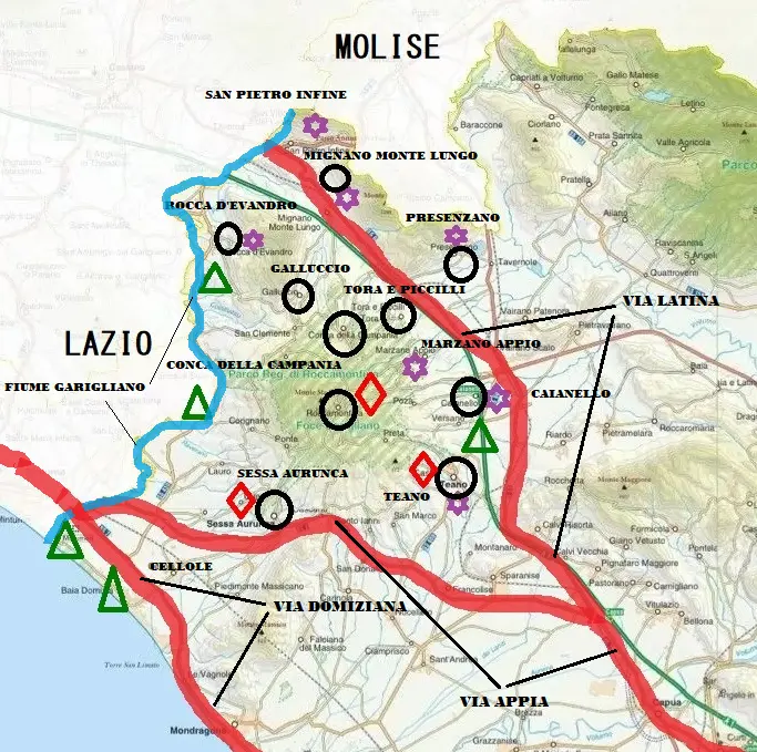
Figure 5. Map of cultural heritage sites in the Roccamonfina area. Legend: black circles indicate historic town centres, red diamonds indicate Roman ruins, purple stars indicate medieval castles, ochre circles indicate the paleontological site of “Ciampate del Diavolo”, green triangles indicate places of natural interest, green areas indicate the Roccamonfina and Foce Garigliano Regional Nature Reserve, and red lines indicate Roman roads. An ochre circle was inserted into the paper because it only appeared in the legend. The blue line corresponds to the Garigliano River, as it is written in the figure.
2.6. Tourist Activities to Promote the Area
According to the data and indicators used by the Italian Institute of Statistics, Presenzano, Tora, and Piccilli are not classified as tourist municipalities. Caianello, Conca della Campania, Galluccio e Marzano Appio. Mignano Monte Lungo, Rocca d’Evandro, San Pietro Infine, and Teano are classified as “tourist municipalities not belonging to a specific category”, while Roccamonfina is classified as a “mountain municipality” and, finally, Sessa Aurunca and Cellole are classified as “maritime municipalities” (Table 7).
Table 7. Tourist Municipalities [36,37].
|
Municipality |
Tourist Category |
Index Offer |
Index Demand |
Economic Activity Connected |
Index Synthetic |
|---|---|---|---|---|---|
|
Caianello |
Tourist municipalities are not classified in a specific category. |
D3 |
P4 |
T4 |
S4 |
|
Conca della Campania |
Tourist municipalities are not classified in a specific category. |
D3 |
P1 |
T4 |
S1 |
|
Galluccio |
Tourist municipalities are not classified in a specific category. |
D3 |
P1 |
T2 |
S1 |
|
Marzano Appio |
Tourist municipalities are not classified in a specific category. |
D1 |
P1 |
T2 |
S1 |
|
Mignano Monte Lungo |
Tourist municipalities are not classified in a specific category. |
D2 |
P2 |
T1 |
S1 |
|
Presenzano |
Non-tourist municipalities |
||||
|
Rocca d’Evandro |
Tourist municipalities are not classified in a specific category. |
D2 |
P1 |
T1 |
S1 |
|
Roccamonfina |
Municipalities with a mountain vocation |
D3 |
P4 |
T4 |
S3 |
|
San Pietro Infine |
Tourist municipalities are not classified in a specific category. |
D4 |
P3 |
T4 |
S3 |
|
Sessa Aurunca |
Municipalities with a maritime vocation |
D5 |
P3 |
T4 |
S5 |
|
Teano |
Tourist municipalities are not classified in a specific category. |
D2 |
P2 |
T4 |
S2 |
|
Tora e Piccilli |
Non-tourist municipalities |
||||
|
Cellole |
Municipalities with a maritime vocation |
D5 |
P4 |
T4 |
S4 |
Legenda: Index = synthetic density index; Supply D, P = demand index, T = related activity index; S = synthetic index (sum of D, P and T). Followed by 1 = very low; 2 = low; 3 = medium; 4 = high; 5 = very high.
The two municipalities overlooking the sea, Sessa Aurunca and Cellole, have higher tourism figures than the others. Sessa Aurunca offers a high level of tourism compared to its medium-sized demand, with significant related economic activities and a very high summary indicator. Cellole is a municipality with a very high tourism offering, high demand, and related activities, resulting in a high summary indicator. Caianello is a tourist municipality that does not belong to a particular tourist category, with a tourist offer considered to be medium, compared to high demand, with a high number of related economic activities and therefore with an overall high-density index. Given this situation, there is only one hotel in the center of Caianello. Conca della Campania, despite its medium tourist offer, has negligible demand, even though related economic activities are high, with a very low synthetic indicator. Galluccio has a medium tourist offer with two agritourism facilities, while demand is very low, with few related economic activities and a generally low synthetic indicator. Marzano Appio has a very low tourist supply and demand, linked to small-scale related economic activities, with a very low summary indicator. Mignano Monte Lungo has a low tourist supply and demand, with related economic activities of negligible importance and a very low summary indicator. Rocca d’Evandro has low tourist supply, with very low demand and related economic activities, resulting in a very low summary indicator. Roccamonfina has an average tourist supply, with significant demand and related economic activities, resulting in an average summary indicator. In the municipality of Roccamonfina, there is potential to increase tourism offerings to improve performance in the tourism sector. San Pietro Infine has high tourism offerings, with medium demand, significant related activities, and an average summary indicator. Teano has low tourism offerings and demand, despite many related economic activities; ultimately, it has a low summary indicator. Presenzano and Tora e Piccilli are not tourist destinations, but Presenzano has two agritourism facilities, while in the territory of Tora e Piccilli, hominid footprints dating back about 350,000 years were discovered about twenty years ago, which have generated considerable tourist interest [38]. According to data available on the web, in addition to the two agritourism facilities in Presenzano, there are two others in the Galluccio area. To clarify the role of tourism in the area and the elements presented in the table, it should be noted that the data are from official Istat statistics and show the discrepancy between the availability of tourist facilities and tourism flows. Limited tourist demand and hospitality are noted, and it is highlighted that incentivizing activities would create an important support for tourism in the area, while also respecting the sites’ sustainability and enhancing them in exchange for the natural capital available to the area. It would be essential to implement services that promote sustainable tourism and related activities, particularly education, training, scientific research, and other compatible recreational pursuits, such as archaeological itineraries that cross both forest trails and Roman roads, like the Appian Way, recently added to the UNESCO World Heritage List. Furthermore, monitoring of the Park’s areas should be encouraged through, according to the Park Authority’s guidelines, the collaboration of local communities and schools with local “Legambiente campaigns”. Still encourage the distribution and dissemination of information materials on the Park Authority and the Authority’s system of protected areas.
3. Results
The presence of the regional nature reserve, combined with the desire to create sustainable development in the area, is the goal of planning, developing, and managing the Roccamonfina area and the mouth of the Garigliano River. One of the goals is to understand how to achieve “economic” results from biodiversity conservation. The promotion of all quality certifications obtained for certain products, primarily chestnuts, olives, oil, mozzarella, and white wines, is the most appropriate direction to continue pursuing. One of the tools in which we believe we can and should invest is the “short supply chain”, a production and consumption model based on the relationship between territoriality, proximity of products and consumption, socialization practices, job security and fair remuneration for those working in the agri-food sector, as well as a relationship of trust between producer and consumer [39,40]. To keep the local market afloat, agricultural producers often sell at a loss, which means there is a lack of investment. Structures, which are based on modest areas, cannot withstand the commercial impact, so instead of moving forward, companies stop; they go backwards, with a reduction in both investment and labour. In the area, the municipality of Mignano Monte Lungo can certainly serve as a model, a good practice in the management of agricultural areas. Mignano Monte Lungo is not just a small town perched on a mountain. However, a town with a glorious past, located at the center of good infrastructure, with particularly fertile flat land, and therefore, from a production and commercial point of view, it is better positioned than other municipalities in the Alto Casertano area. In recent years, Mignano Monte Lungo has invested in improving its irrigation network, increasing the cultivated area and improving the UAA from 1709 hectares to over 2000 hectares of land. This has led to a specialised change in cultivation, both for irrigated arable land and for horticultural crops and orchards specialised in new varieties. This process, through public intervention, has increased mechanisation and encouraged the formation of small industries processing agricultural products. Furthermore, great importance has been given to archaeological elements that are particularly significant for the area, so that they can be promoted as an element of notable interest. In this regard, a project has been launched to implement a tourism initiative that considers all the specific characteristics of the area, whether landscape, environmental, archaeological, architectural, artistic, tangible or intangible, capable of enhancing the entire territory through joint public and private initiatives. Another strength that could become a driving force for the area is the promotion of cultural itineraries that combine landscape aspects with historical-archaeological, architectural-urban planning, and environmental aspects.
Using SWOT analysis (Table 8), the Park Plan was linked to the Territorial and Landscape Plan to form a comprehensive framework of territorial planning guidelines and interventions to improve economic capacity. The area has great potential that can be used to improve the quality of life of local communities and promote development more in line with the specific characteristics of the area. Table 8 summarises the potential problems, opportunities, and threats of the Roccamonfina area. The proposed SWOT categories derive from scientific meetings with experts in the faunal, agronomic, geological, botanical, and political sciences, as well as in the ecological sector. As part of projects aimed at enhancing protected natural areas, particularly those in the Campania Region, which were co-financed by the authors, it was possible to study the topic with the support of experts, institutions, and representatives of local communities. As part of the project activities, a conference entitled Protected Areas in Italy: The Case of the Campania Region was organised in 2012. Regarding the Swot analysis, the chosen criteria are identified on the basis of the identity characteristics of the territories, believing that the historical values in the chosen areas represent determining elements for the purposes of a coherent and sustainable analysis.
Table 8. Swot Analysis of the Roccamonfina area. Legend: PA = Environmental Heritage; PC = Cultural Heritage; PP = Landscape Heritage.
|
STRENGTHS |
WEAKNESSES |
|
|---|---|---|
|
PA |
Protected Geographical Indication for Roccamonfina Chestnuts recognised by the European Union |
Poor land connections and Inadequate infrastructure |
|
PA |
Terre Aurunche extra virgin olive oil, recognised by the Campania Region |
Distance from the main maritime connections (Naples and Formia) |
|
PA |
The Roccamonfina designation Typical Geographical Indication for wine-growing areas recognised at the national level |
Poor propensity for innovation. |
|
PA |
Regional-level protected nature area |
Poor management aptitude |
|
PC |
Cultural itineraries |
Low propensity to make a system for economic and cultural initiatives |
|
PC |
The presence of archaeological sites in the cities of Sessa Aurunca and Teano |
Scarcity of professional figures qualified in particular for the agronomic profile |
|
PC |
Devils Food |
Lack of knowledge and information about the potential of their territory to produce material wealth |
|
PC |
Part of the Appian Way (UNESCO World Heritage Site) from the Roman era |
Weak internet connections |
|
PC |
Section of the Roman road Via Latina |
Lack of knowledge of their territory |
|
PC |
Section of the Roman road Via Domiziana |
Lack of skills to turn strengths into economic and cultural driving forces |
|
PP |
Mountainous landscape area consisting of tall forests |
Poor protection of bushy and tree-lined areas |
|
PA |
Coastal area of interest |
Absence of the Park Plan |
|
PA |
Garigliano River e Savone River |
Presence of the decommissioned nuclear plant. |
|
PP |
Final tract of the Garigliano River |
Elements of visual impact. Environmental and landscape aspects of the rural context |
|
PA |
Special Conservation Areas and Special Protection areas |
|
|
PP/C |
Agricultural landscape area on a slope or valley floor of environmental interest |
|
|
PP |
Urbanised landscape characterised by monumental features of a recently discovered archaeological site. |
|
|
PC |
The areas of Monte La Frascara and Monte S. Croce Archaeological Park. |
|
|
PA |
Thermal springs |
|
|
PA |
The wilderness areas |
|
|
PP |
The wealth of natural beauty |
|
|
OPPORTUNITY |
THREATS |
|
|
Landscape Plan |
||
|
Recognition of the anthropic landscape of the historical settlement of significant perceptual and environmental interest |
Hydrogeological instability |
|
|
Historic centres included in the park area |
Agricultural nutrient contamination |
|
|
Recognition of an urbanised landscape characterised by monumental features of a recently discovered archaeological site. |
Poor promotion of the territory |
|
|
The areas of the Archaeological Park of Monte ‘La Frascara’ and Monte S. Croce |
||
|
Agricultural Consulting Services |
Low propensity to vocational training by local communities |
|
|
Measures for the gradual elimination of discharges, emissions and losses of priority hazardous substances |
Restarting of the Sessa Aurunca nuclear reactor |
|
|
Classification of the ecological potential of all artificial and heavily modified water bodies |
Pesticide pollution from agricultural sources agricola |
|
|
“Monte Santa Croce” Mountain Community |
To keep the local market afloat, agricultural producers often sell below cost, which means investment is lacking. The structures, which are based on modest areas, cannot withstand the commercial impact, so instead of moving forward, companies are standing still, going backwards, with a reduction in both investment and labour. In the area, the municipality of Mignano Monte Lungo can certainly serve as a model, a good practice in the management of agricultural areas. Mignano Monte Lungo is not just a small town perched on a mountain, but a town with a glorious past, located at the centre of good infrastructure, with particularly fertile flat land, so from a productive and commercial point of view, it is in a better position than other municipalities in the Alto Casertano area. In recent years, Mignano Monte Lungo has invested in improving its irrigation network, expanding cultivation, and increasing the UAA from 1709 hectares to over 2000 hectares. This has led to a specialised change in cultivation, both for irrigated arable land and for vegetable crops and specialised orchards with new varieties. This process, through public intervention, has increased mechanisation and encouraged the formation of small agricultural product processing industries.
4. Discussion
The fragmented knowledge of the state of natural resources, a poor perception of environmental heritage as a significant resource for development, the fragility of public bodies responsible for environmental and land management, serious delays in the implementation of sector regulations and a lack of planning and programming tools are the main problems affecting the Roccamonfina area promoting the ecological network as an infrastructure supporting compatible development and as a system for offering goods, resources, and values. One of the most important, structural, and decisive objectives for the area under study is to protect soil resources from indiscriminate damage, defending an economic and strategic resource for the environment and landscape. Promoting sustainable agriculture models, directing intervention actions towards supporting organic farming, agronomic techniques aimed at increasing organic matter and soil biodiversity, efficient use of natural resources used in agricultural production processes (soil, solar energy, and water), and the reuse of by-products from agricultural and agri-food activities as raw materials for energy production. Sustainable agricultural models were those that promote, enhance, and support crops, livestock, and forestry. The final document of the Rio +20 Conference, entitled “The future we want”, states “the need to promote, enhance and support sustainable agriculture, including crops, livestock, forestry, fisheries and aquaculture”: this way of farming is closely linked to ‘improving food security’, as it ‘eradicates hunger and is economically viable when it conserves land, water, flora and animal genetic resources, biodiversity and ecosystems, and improves resilience to climate change and natural disasters’. Among the models considered, the ‘Chianti Biodistrict’ model was analysed, where, in addition to production methods that use fewer chemicals to treat vine diseases and less mineral fertilisers, winegrowers practise sustainable viticulture because they also care about protecting resources of collective interest. In this case, they contribute to protecting and enhancing publicly owned resources, which belong to everyone and are exhaustible. This is the case, for example, with water resources and biodiversity. Winemakers are concerned about how much water they consume during their production cycle and aim to reduce consumption, avoiding pollution of the source (wells, aquifers), thereby embarking on a path of sustainable viticulture. The same applies to biodiversity, a public resource that has recently been enshrined in our Constitution. The Biodistrict winegrower cares about the biodiversity of flora and fauna, which is promoted by the presence of woods, hedges, or a little uncultivated land around the vineyard, or, if they prefer, by using native vines alongside other varieties in their vineyard, which promotes a sustainable viticulture production model. No conservation projects have ever been launched that, based on the above, should focus on clearly defined areas of major landscape and conservation importance, such as dune habitats, chestnut groves, watersheds, and water [41]. The promotion of food and local specialities can also contribute to the conservation of agricultural landscapes through specific tourist offerings that complement traditional ones. Relocalising production and processing activities that enhance the natural resources of the area by involving farms in conservation efforts is another good practice that could be implemented. Little or nothing has been done to promote the Garigliano estuary, where the conservation of dune habitats, which can help combat coastal erosion, is of paramount importance. Given the importance of the Lake Corree biotope in the intensive agricultural landscape in which it is located, greater protection is desirable, preferably as an integral reserve as envisaged in the initial zoning of the park. Similarly, it would be important to include Lake Vairano, less than 4 km from Lake Corree, in the park. Finally, the entire course of the Savone delle Ferriere stream between its sources and the plain preserves evidence of natural history, at least from a botanical point of view, such that it requires targeted conservation projects and greater protection against regulation, redevelopment, exploitation and “enhancement” projects that are occasionally proposed and could lead to the definitive disappearance of habitats and species of great importance. Another important objective is to reverse the process of depopulation affecting many of Italy’s inland areas and small towns in the south [42]. The productive landscape can take on links between production, the state of the environment, and common well-being. The new millennium has inherited a rural landscape that, while retaining some areas of extraordinary agronomic, ecological-environmental, and cultural value, is extremely fragile in its balance, vulnerable, clearly critical, impoverished in diversity, and artificially maintained in its structure only thanks to the use of costly external inputs. One of the strategic objectives for sustainable land management is to achieve the resilience of agrarian landscapes, an adaptive capacity to changes caused by different forces at work, from urbanisation and land consumption to hydrological instability and climate change. Resilience and landscape quality are among the characteristics that define sustainable agriculture. The integration between agronomic and ecological practices is emerging as a winning approach to combine crop profitability and the long-term provision of diversified ecosystem services, also through the tools offered by the new Common Agricultural Policy (2014–2020). To this end, knowledge of a landscape design methodology capable of integrating with plant design, crop management, production planning, and, subsequently, routine farm management is essential. A company-scale landscape project requires the ability to read its components and possible levels of intervention, ranging from hydraulic-agricultural systems and soil to buffer areas of cultivated spaces to more or less preserved natural ecosystems in non-productive areas. Bringing the landscape project into the production chains, especially those of tree crops, which, as multi-year programs, are already designated as strategic systems for sustainable global agriculture, will strengthen the competitiveness of this important sector of Italian agriculture, which includes some of the world’s most well-known and appreciated typical and traditional products [43]. In this regard, landscape-scale planning also plays a role, extending nature conservation objectives and tools well beyond the boundaries of protected areas to the surrounding land and marine areas. Over the last twenty years, scientific and institutional debate at the international level has led to a change in nature conservation paradigms, with conservation and enhancement objectives increasingly integrated with global economic and social issues, emphasising the role and responsibility of local communities in defining and implementing strategies. The achievement of a “good” ecological status for the upper Caserta area is still far from being achieved [44]. National and regional regulations on the protection of water from agricultural nitrates (Campania Region, 2019, 2023) and pollution from civil and industrial waste (Legislative Decree 152/2006) will take effect at an unpredictable time, making it difficult, if not impossible, to predict whether the objective will be achieved and maintained over time by 2027. It is necessary to eradicate poaching, which is particularly concentrated in the coastal and dune areas during the spring migration period; safeguard the natural banks of the Garigliano river and the areas where reeds grow, which are a necessary habitat for the reproduction of various species of water birds; regulate forest cutting to make it compatible with the reproductive needs of forest species; constantly monitor birdlife to keep the environmental situation under control, bearing in mind that birds are considered excellent environmental indicators [45].
5. Conclusions
The first step is to draw up the Park Plan, the main tool for park planning in Italy. This urban planning tool can be used to consider both the conservation of environmental biodiversity and the development of initiatives to promote the economic, social, and cultural development of the area, as expressly provided for by the national law on protected areas. A new food strategy must become a tool for governing and safeguarding natural capital, reducing the environmental impact of human activities, and protecting the territory. Food planning is an innovative method suitable for areas rich in rural traditions, capable of guiding planning choices in such a way as to conserve natural capital and biodiversity while promoting the formation of new markets and innovation pathways with significant economic and employment benefits. It is in this context that an important, and for us decisive, role can be played by the implementation of processes, leading to the creation of a genuine supply chain that supports the “Mediterranean Diet”. The new geography of food, strongly linked to the “Mediterranean Diet”, is not simply about the product and its intrinsic characteristics, but about a process in which environmental quality, mobility, social equality, health, employment and education can together define a new geography. One of the key elements on which the Mediterranean Diet is based is undoubtedly the application of the ‘short supply chain, which guarantees not only the quality of food but also the seasonality of local produce. In our opinion, the quality of the atmosphere, authenticity and identity of places capable of attracting tourist demand, which is slowly beginning to include such places, small communities rich in cultural and social characteristics specific to inland and secluded areas, could prove decisive. The search for the cultural identity of a place through direct contact with the vestiges of antiquity, the traditions of a population, its food and wine culture, and craftsmanship allows travellers to appreciate the authenticity of the experience of a community that manages to evoke memories of times gone by. For the cultural tourist, or rather, for the “traveller” curious about culture, it is often a question of discovering realities steeped in history, of enjoying landscapes now distant in time and space, while for operators and territories it represents a significant opportunity to generate economic resources and development sustainably. The concept of cultural tourism has expanded from cities of art (according to the latest national statistics) to include villages and lesser-known historic centers that are also rich in history and tradition. It has also broadened to include activities that can contribute to expanding one’s knowledge and, above all, experiences [46]. The paper aims to contribute to the development of tourism, offering benefits for local areas capable of generating economic, employment, and social cohesion. Given its multifaceted nature and versatility, as well as the size and significance of Italy’s inland areas (not unlike Spain, France, England, Germany, Poland and Hungary). Local administrations and operators should increasingly commit themselves to planning activities and development plans, promoting the systematisation of the area’s strengths in a logic of territorial marketing that invests in the promotion of the territory [47]. Chestnut cultivation, which affects the entire Roccamonfina area, represents a fundamental part of the economy that requires significant investment and the development of harvesting staff, as well as the creation of product processing companies that do not alter the landscape’s sustainability. The Teano area enjoys a naturalistic, rural, and historical landscape of considerable interest, relying both on the ecological balance of its territory and on its historical, architectural, and archaeological components, thanks to the presence of a historic center of architectural and urban interest. This center should be enhanced with tourism promotion projects, along with the rural landscape, which preserves old, often abandoned, farmhouses that can be restored. Galluccio is the area that has invested par excellence in wine production and has already achieved a quality product that must find greater space and investment in the distribution of the already certified product. Tora and Piccilli can invest in “devil’s swipes” by creating a reception system around paleoanthropological recognition that allows for a widespread increase in tourist offerings by recovering existing buildings. Sessa Aurunca, by far the most important center in the area, will be able to invest both in the most careful protection of the mouth of the Garigliano River, in the promotion and enhancement of archaeological features such as the Roman-era theater (built using Greek techniques), which is the largest in the entire Campania region, and in the restoration of the entire historic center, which is particularly abandoned. Another notable architectural element is the Sessa Aurunca Cathedral, which is particularly interesting in a national context but also little known in the region. Furthermore, the Sessa Aurunca area is crossed by the Appian Way, the Roman “Queen Viarum”, which is included in the 2025 World Heritage List under the aegis of UNESCO. Taking its cue from its recent recognition, it can enhance this presence and build a cultural offering around it, both as a promotional tool and through related activities. Marzano Appio, which features a largely abandoned area that could be affected by organic farming interventions capable of recovering and making a largely abandoned area productive. Regarding its architectural and historical heritage, the castle, transformed into a noble palace that housed the powerful Marzano family from the 15th to the 17th century, is in a state of abandonment and could be restored, both historically, artistically, and architecturally, along with its surroundings, which retain traces of now abandoned rural architecture. The municipality of Caianello can count on an oil production of recognised international importance, underlined by PGI certifications. In addition to improving and extending oil production, the supply chain surrounding this component could also be enhanced. Oil mills and agritourism activities could be encouraged and, above all, promoted in both the Neapolitan and Roman metropolitan areas (Caianello is approximately 45 min from Naples and 90 min from Rome), as the area’s position is central to the two urban areas. Finally, Conca della Campania is a small town with a center that needs to be revitalised through a landscape restoration of the area, including the town center, which remains somewhat distant from the main flows. To these simple considerations must also be added the promotion and valorisation of routes that can be of a historical, paleoanthropological, archaeological, architectural, urban planning, landscape and rural nature.
Acknowledgments
We would like to thank the Institute of Mediterranean Studies of the National Research Council and Paolo Pironti for their contribution to the editing.
Author Contributions
Conceptualisation, A.B. and T.V.; Methodology, A.B. and T.V.; Validation, A.B. and T.V.; Formal Analysis, A.B. and T.V.; Investigation, A.B. and T.V.; Data Curation, A.B.; Writing—Original Draft Preparation, A.B. and T.V.; Supervision, A.B. and T.V.
Ethics Statement
Not applicable.
Informed Consent Statement
Not applicable.
Data Availability Statement
The statement is required for all original articles which inform readers about the accessibility of research data linked to a paper and outline the terms under which the data can be obtained.
Funding
This research received no external funding.
Declaration of Competing Interest
The authors declare that they have no known competing financial interests or personal relationships that could have appeared to influence the work reported in this paper.
References
- Ambiente E Territorio Istat. Available online: https://www.istat.it/wp-content/uploads/2024/02/Ambiente-e-territorio-Ebook.pdf (accessed on 8 January 2025).
- Lucatelli S. La strategia nazionale, il riconoscimento delle aree interne. TERRITORIO 2015, 74, 80–86. DOI:10.3280/TR2015-074014 [Google Scholar]
- Available online: https://www.instm.it/public/03/33/Bioeconomia%20%202025.pdf (accessed on 30 September 2025).
- Istituto Superiore per la Protezione e la Ricerca Ambientale (ISPRA). Il consumo di suolo in Italia. 2014. Available online: https://www.isprambiente.gov.it/files/pubblicazioni/rapporti/Rapporto_Consumo_di_Suolo_in_Italia_2014.pdf (accessed on 15 February 2025).
- Available online: https://www.mase.gov.it/portale/documents/d/guest/2_snb_2030_marzo_23-pdf (accessed on 6 November 2025).
- Blum A. Drought resistance, water use efficiency, and yield potential—Are they compatible, dissonant, or mutually exclusive? Aust. J. Agric. Res. 2005, 56, 1159–1168. DOI:10.1071/AR05069 [Google Scholar]
- European Commission. 2006. Available online: https://eur-lex.europa.eu/LexUriServ/LexUriServ.do?uri=COM:2006:0231:FIN:it:PDF (accessed on 1 March 2025).
- Haygarth e Ritz. 2009. Available online: https://www.researchgate.net/publication/222394947_The_future_of_soils_and_land_use_in_the_UK_Soil_systems_for_the_provision_of_land-based_ecosystem_services (accessed on 16 January 2025).
- Turbé A, de Toni A, Benito P, Lavelle P, Lavelle P, Camacho NR, et al. 2010. Available online: https://hal-bioemco.ccsd.cnrs.fr/bioemco-00560420/file/biodiversity_report.pdf (accessed on 16 January 2025).
- Available online: https://www.mdpi.com/2071-1050/16/19/8303 (accessed on 2 February 2026).
- International Assessment of Agricultural Knowledge, Science and Technology for Development, IAASTD. 2009. Available online: https://www.fao.org/fileadmin/templates/est/Investment/Agriculture_at_a_Crossroads_Global_Report_IAASTD.pdf (accessed on 22 February 2025).
- Bertini A. Introduzione. Aree protette, comunità locali e centri abitati. In Aree protette in Italia. Il caso della Campania; Bertini A, Nicoletti D, Russo GF, Vitolo T, Eds.; Rubbettino: Soveria Mannelli, Italy, 2015. [Google Scholar]
- Available online: https://clusterspring.it/ (accessed on 4 June 2025).
- artt. 9 e 41 Legge 1/2022. Available online: https://www.normattiva.it/uri-res/N2Ls?urn:nir:stato:legge.costituzionale:2022-02-11;1 (accessed on 6 June 2025).
- Anna Marson A. (Ed.) Urbanistica e Pianificazione Nella Prospettiva Territorialista, Quodlibet: Macerata, Italy, 2019; ISBN 9788822904140. [Google Scholar]
- Available online: https://www.regione.campania.it/assets/documents/Leggeregionale33.pdf (accessed on 6 February 2025).
- Piano Territoriale Regionale dalla Campania. Available online: https://www.regione.campania.it/regione/it/tematiche/piano-territoriale-regionale-ptr/piano-territoriale-regionale?page=1 (accessed on 3 March 2025).
- Available online: https://www.unesco.it/it/iniziative-dellunesco/patrimonio-mondiale/via-appia-regina-viarum-2/ (accessed on 4 Septemper 2025).
- Available online: https://www.tuttitalia.it/campania/statistiche/censimento-2021/ (accessed on 16 June 2025).
- Available online: https://www.istat.it/comunicato-territoriale/censimento-della-popolazione-dati-regionali-anno-2023/ (accessed on 16 June 2025).
- Available online: https://politichecoesione.governo.it/media/3167/snai-dossier-regionale-campania.pdf (accessed January 14, 2026 [Google Scholar]
- Available online: https://halleyweb.com/c061051/zf/index.php/servizi-aggiuntivi/index/index/idtesto/20126 (accessed on 27 October 2025).
- Available online: https://www.comunitamontanasantacroce.it/hh/index.php (accessed on 12 November 2025).
- Available online: https://environment.ec.europa.eu/topics/nature-and-biodiversity/natura-2000_en (accessed on 10 June 2025).
- Croce A, La Valva V, Motti R, Nazzaro R, Strumia S. La flora vascolare del Vulcano di Roccamonfina (Campania, Italia). Webbia 2008, 63, 251–291. DOI: 10.1080/00837792.2008.10670844 [Google Scholar]
- Elenco siti Italiani. Il sito di Interesse Comunitario “Pineta della Foce del Garigliano”. Available online: https://agricoltura.regione.campania.it/statistica/statistica_VII_censimento.html (accessed on 16 June 2025).
- Pennetta M, Corbelli V, Gattullo V, Nappi R. Pineta della Foce del Garigliano: Introduzione e Inquadramento Generale. 2014. Available online: https://sites.unica.it/providune/2014/04/29/pineta-della-foce-del-garigliano-introduzione-e-inquadramento-generale/ (accessed on 18 June 2025).
- Croce A, Catalano I, Maio N. (Eds.) Il Patrimonio Naturalistico del Parco Regionale Area Vulcanica di Roccamonfina e Foce Garigliano; FedOAPress-Federico II University Press: Naples, Italy, 2024. DOI: 10.6093/978-88-6887-231-1 [Google Scholar]
- Available online: https://agricoltura.regione.campania.it/statistica/statistica_VII_censimento.html (accessed on 29 March 2025).
- Available online: http://vnr.unipg.it/habitat/index.jsp (accessed on 8 May 2025).
- Available online: https://www.wilderness.it/sito/aree-wilderness-campania/ (accessed on 29 March 2025).
- Croce A. Siti, habitat e specie di maggiore interesse per la biodiversità vegetale del parco Regionale Area Vulcanica di Roccamonfina e Foce Garigliano. In Proceedings of the Il patrimonio naturalistico del Parco Regionale Area Vulcanica di Roccamonfina e Foce Garigliano, Caserta, Italy, 30 September 2023; pp. 29–32. DOI:10.6093/978-88-6887-231-1 [Google Scholar]
- Fraissinet M, Del Bene M. L’avifauna del Parco. In Il patrimonio naturalistico del Parco Regionale Area Vulcanica di Roccamonfina e Foce Garigliano; Croce A, Catalano I, Nicola Maio N, Eds.; FedOAPress-Federico II University Press: Napoli, Italy, 2024 DOI:10.6093/978-88-6887-231-1. [Google Scholar]
- Berechman J. Transportation-economic aspects of Roman highway development: The case of Via Appia. Transp. Res. Part A Policy Pract. 2003, 37, 453–478. DOI:10.1016/S0965-8564(02)00056-3 [Google Scholar]
- Ceraudo G. La via Latina tra Fabrateria Nova e Casinum: Precisazioni topografiche e nuovi spunti metodologici. In Archeologia Aerea: Studi di Aerotopografia Archeologica; Libreria dello Stato: Rome, Italy, 2003; pp. 442–445. [Google Scholar]
- Longobardo F. Problemi di viabilità in Campania: La via Domitiana. In Viabilità e insediamenti nell’Italia antica; L’Erma di Bretschneider: Rome, Italy, 2004; p. 289. [Google Scholar]
- Available online: https://www.istat.it/classificazione/classificazione-dei-comuni-in-base-alla-densita-turistica/ (accessed on 26 June 2025).
- Mietto P, Panarello A, Avanzini M, Sirano F, Santello L, Belvedere M, et al. Ciampate del diavolo: Le impronte dei primi uomini sul vulcano Roccamonfina; Spolia: Rome, Italy, 2013. [Google Scholar]
- Marino D, Cavallo A. (Eds.) Agricoltura, cibo e città, verso sistemi socio-ecologici resilienti; Cursa: Rome, Italy, 2014. [Google Scholar]
- Strickland-Munro JK, Allison HE, Moore SA. Using resilience concepts to investigate the impacts of protected area tourism on communities. Ann. Tour. Res. 2010, 37, 499–519. DOI:10.1016/j.annals.2009.11.001 [Google Scholar]
- Viglietti S, Gramegna C. L’applicazione della Direttiva Quadro Acque (2000/60/CE) nell’alto casertano: Il Biomonitoraggio delle macrofite acquatiche e l’indice IBMR. In Il patrimonio naturalistico del Parco Regionale Area Vulcanica di Roccamonfina e Foce Garigliano; Croce A, Catalano I, Maio N, Eds.; FedOAPress-Federico II University Press: Napoli, Italy, 2024; p. 32. DOI:10.6093/978-88-6887-231-1 [Google Scholar]
- Bertini A. Per i centri abitati “poco noti”. In Turismi e turisti, Politica, innovazione, economia in Italia in età contemporanea; Avallone P, Strangio D, Eds.; Franco Angeli: Milan, Italy, 2005; pp. 207–226. [Google Scholar]
- Laino A, Scarnicci M, Borsacchi L, Romani A. Bioeconomy and Green Economy: From Theory to Practice. Case Study of a Tuscan Micro-Enterprise. Int. J. Humanit. Soc. Sci. 2013, 3, 170–183. [Google Scholar]
- Tampekis S. Optimizing forest road networks for economic environmental and hazard impacts using a resilient Markov Monte Carlo approach. Discov. For. 2025, 1, 26. DOI:10.1007/s44415-025-00026-z [Google Scholar]
- Colvin RM, Witt GB, Lacey J. The social identity approach to understanding socio-political conflict in environmental and natural resources management. Glob. Env. Change 2015, 34, 237–246. DOI:10.1016/j.gloenvcha.2015.07.011 [Google Scholar]
- Martínez Quintana V. El turismo de naturaleza: Un producto turístico sostenible. Arbor 2017, 193, a396. DOI:10.3989/arbor.2017.785n3002 [Google Scholar]
- Gross M, Pearson J, Arbieu U, Riechers M, Thomsen S, Martin-Lopez B. Tourists’ valuation of nature in protected areas: A systematic review. Ambio 2023, 52, 1065–1084. DOI:10.1007/s13280-023-01845-0 [Google Scholar]