Found 4 results
Article
30 August 2024Fast-Track Documentation of the Alterations on the Landscape, before and after a Natural Hazard—Case Study: North Euboea Greece before and after Storms Daniel and Elias
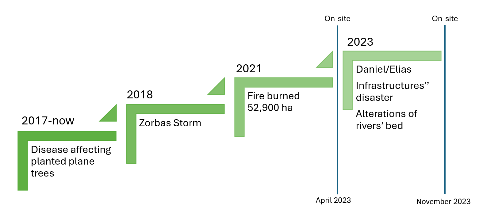
This paper presents a methodology for fast-track documentation of landscape alterations before and after natural hazards, specifically focusing on the impacts of storms Daniel and Elias (2023) in Northern Euboea, Greece, which flooded larger areas than the storm Zorbas (2018). This happened because the plane trees had been affected by the disease Ceratocystis platani and had dried up, and the forest had burned. Therefore, the water moved faster, and in recent storms, the riverbed widened. This research aims to capture the transformed landscape rapidly by utilizing modern mapping technologies, including Google Earth, digital terrain models and drone-based photogrammetry. The methodology involves on-site inspections and the creation of three-dimensional models to document and analyze the affected areas. This approach facilitates a more comprehensive understanding of how the landscape can dynamically change due to a natural disaster. It highlights the importance of the on-site landscape inspection with sophisticated tools based on commercial equipment and open-source software.
Article
25 July 2024A Distributed Framework for Persistent Wildfire Monitoring with Fixed Wing UAVs
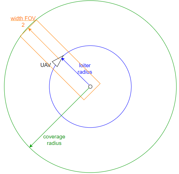
Wildfires have proven to be a significantly exigent issue over the past decades. An increasing amount of research has recently been focused on the use of Unmanned Aerial Vehicles (UAVs) and multi-UAV systems for wildfire monitoring. This work focuses on the development of a decentralized framework for the purpose of monitoring active wildfires and their surrounding areas with fixed wing UAVs. It proposes a distributed fire data update methodology, a new formation algorithm based on virtual forces, fine-tuned by a Genetic Algorithm (GA), to arrange virtual agents into the monitoring area, and a control strategy to safely and efficiently guide fixed wing UAVs to loiter over the structured virtual agents. The system is tested in Software In The Loop (SITL) simulation with up to eight UAVs. The simulation results demonstrate the effectiveness of the system in monitoring the fire in a persistent manner and providing updated situational awareness data. The experiments show that the proposed framework is able to achieve and maintain coverage up to 100% over the area of interest, and very accurate fire representation. However, the performance is decreased for the experiments with low UAV numbers and large fire sizes.
Article
10 July 2024Documenting the Changing Floodplain of Nileas Basin in North Euboea (Greece) before and after Storms Daniel and Elias
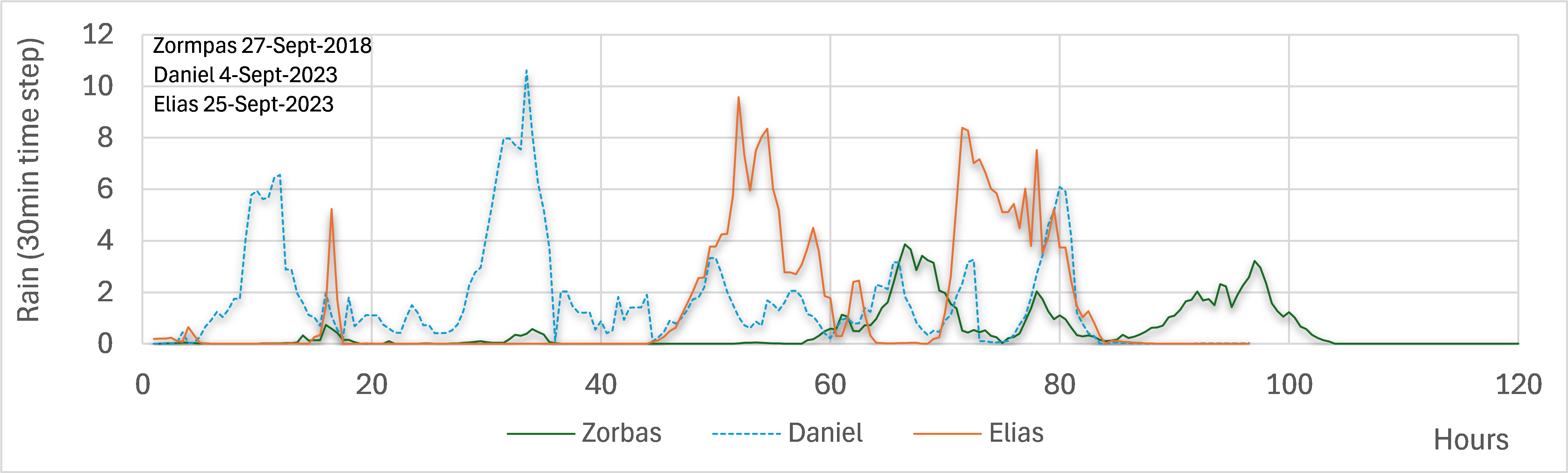
The area of north Euboea is characterized by its intense relief, dense hydrographic network, and rich flora and fauna. In the mid-2010s, the region was struck by a plane tree disease that withered the large population of plane trees in the area, while in 2021, a large wildfire completely burned the forest. These unfortunate events depleted the landscape’s natural ability to manage and mitigate flood phenomena. Observing the landscape’s vulnerability to floods, in April 2023, we conduct on-site field inspections in the rivers of the area. In September 2023, a major flood hit the area, causing in dramatic changes to the landscape. Therefore, in November 2023, we conducted follow-up on-site field inspections in the area, in order to trace the differences, present the damages the phenomenon left behind. These inspections allowed to document the landscape changes from the combination of all previous events and identify any associated pathologies. Site visits and comparisons before and after the Daniel/Elias storm revealed dramatic changes in the riverbed width at lower altitudes, significant sediment accumulation in the Voudouros River delta, alterations in the natural landscape along the river and its floodplain, destruction of the arable land, and road collapses in several locations.
Article
05 June 2024An Architecture for Early Wildfire Detection and Spread Estimation Using Unmanned Aerial Vehicles, Base Stations, and Space Assets
This paper presents, an autonomous and scalable monitoring system for early detection and spread estimation of wildfires by leveraging low-cost UAVs, satellite data and ground sensors. An array of ground sensors, such as fixed towers equipped with infrared cameras and IoT sensors strategically placed in areas with a high probability of wildfire, will work in tandem with the space domain as well as the air domain to generate an accurate and comprehensive flow of information. This system-of-systems approach aims to take advantage of the key benefits across all systems while ensuring seamless cooperation. Having scalability and effectiveness in mind, the system is designed to work with low-cost COTS UAVs that leverage infrared and RGB sensors which will act as the primary situational awareness generator on demand. AI task allocation algorithms and swarming-oriented area coverage methods are at the heart of the system, effectively managing the aerial assets High-level mission planning takes place in the GCS, where information from all sensors is gathered and compiled into a user-understandable schema. In addition, the GCS issues warnings for events such as the detection of fire and hardware failures, live video feed and lower-level control of the swarm and IoT sensors when requested. By performing intelligent sensor fusion, this solution will offer unparalleled reaction times to wildfires while also being resilient and reconfigurable should any hardware failures arise by incorporating state of the art swarming capabilities.