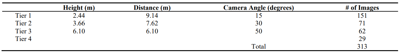
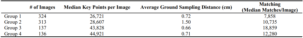
Communication Open Access

Evaluating Different UAS Flight Methods for 3D Model Generation and Printing of a Tornado Destroyed Cultural Heritage: Caddo House in Texas

Drones and Autonomous Vehicles. 2024, 1(1), 10003 ; https://doi.org/10.35534/dav.2023.10003
Yanli Zhang 1 *    David Kulhavy 1    Joseph Gerland 2    I-Kuai Hung 1    Daniel Unger 1    Xiaorong Wen 3    Reid Viegut 1   
1
Arthur Temple College of Forestry and Agriculture, Stephen F. Austin State University, Nacogdoches, TX 75962, USA
2
Castilaw Environmental Services, Nacogdoches, TX 75965, USA
3
College of Forestry, Nanjing Forestry University, Nanjing 210037, China
*
Authors to whom correspondence should be addressed.

Received: 26 Oct 2022    Accepted: 21 Feb 2023    Published: 03 Mar 2023   

Abstract

In recent years, the use of Unmanned Aerial Systems (UAS) to obtain imagery for photogrammetry has become commonplace. Using these data to develop 3D products has also grown significantly in both research and commercial applications. This study aims to find a relatively simple and low cost UAS flight method as a means to obtain data to produce a 3D model suitable for 3D printing. The study subject chosen to assess different flight methods was the Caddo House at Caddo Mounds State Historical Site located near Alto, Cherokee County, Texas, USA. To collect images for analysis, a DJI Phantom 4 Pro UAS was used. Pix4DCapture was used to fly the drone. Two main missions were carried out, one being a pre-defined double-grid flight, and the other being an orbital free-flight method. The findings of this study indicate that if the goal is to create a true-to-life 3D model of an object using UAS, the best method would be a curated orbital free-flight method. If there is time constraint and the subject is sufficiently large and not considerably irregular, a double-grid method with sufficient forward overlap and side overlap can produce desirable results, but with a slight loss of fine details. The 3D model developed from the curated orbital flight method was successfully printed with a customer grade FDM 3D printer.

References

1.
Pagliari D, Rossi L, Passoni D, Pinto L, De Michele C, Avanzi F. Measuring the volume of flushed sediments in a reservoir using multi-temporal images acquired with UAS. Geomat. Nat. Hazards Risk 2017, 8, 150–166. [Google Scholar]
2.
Iqbal F, Lucieer A, Barry K, Wells R. Poppy crop height and capsule volume estimation from a single UAS flight. Remote Sens. 2017, 9, 647. [Google Scholar]
3.
Lowe DG. Distinctive image features from scale-invariant key points. Int. J. Comput. Vis. 2004, 60, 91–110. [Google Scholar]
4.
Westoby MJ, Brasington J, Glasser NF, Hambrey MJ, Reynolds JM. ‘Structure-from-Motion’ photogrammetry: A low-cost, effective tool for geoscience applications. Geomorphology 2012, 179, 300–314. [Google Scholar]
5.
Triggs B, McLauchlan P, Hartley R, Fitzbibbon A. Bundle adjustment—a modern synthesis. In Vision Algorithms: Theory and Practice; Triggs B, Zisserman A, Szeliski R, Eds.; Springer-Verlag: Berlin, Germany, 2000; pp. 298–372.
6.
Oniga E, Chirilă C, Stătescu F. Accuracy assessment of a complex building 3d model reconstructed from images acquired with a low-cost UAS. Int. Arch. Photogramm. Remote Sens. Spat. Inf. Sci. 2017, 42, 551–558. [Google Scholar]
7.
Stratasys Heated Build Chamber for 3D Printer Patent US6722872B1 Set to Expire This Week. Available online: https://3dprintingindustry.com/news/stratasys-heated-build-chamber-for-3d-printer-patent-us6722872b1-set-to-expire-this-week-185012/ (accessed on 24 October 2022).
8.
Yap YL, Tan YSE, Tan HKJ, Peh ZK, Low XY, Yeong WY, et al. 3D printed bio-models for medical applications. Rapid Prototyp. J. 2017, 23, 227–235. [Google Scholar]
9.
Themistocleous K, Ioannides M, Agapiou A, Hadjimitsis, DG. The methodology of documenting cultural heritage sites using photogrammetry, UAV, and 3D printing techniques: the case study of Asinou Church in Cyprus. In Proceedings of the 3rd International Conference on Remote Sensing and Geoinformation of the Environment, Chloraka, Cyprus, 16 March 2015.
10.
Almeshal AM, Mohammad RA, Abdullah KA. Accuracy assessment of small unmanned aerial vehicle for traffic accident photogrammetry in the extreme operating conditions of Kuwait. Information 2020, 11, 442. [Google Scholar]
11.
Caddo Mounds State Historic Site. Available online: https://www.tshaonline.org/handbook/entries/caddo-mounds-state-historic-site (accessed on 24 October 2022).
12.
Strong as Grass: A year after a devastating tornado, the Caddo Nation rebuilds in East Texas. Available online: https://www.texasmonthly.com/being-texan/year-after-tornado-caddo-nation-rebuilds-east-texas/ (accessed on 10 September 2022).
13.
Leysath M, Galen R. Shahó and the power of place. Teach. Artist. J. 2021, 19, 1–13. [Google Scholar]
14.
Hawkins S. Using a drone and photogrammetry software to create orthomosaic images and 3D models of aircraft accident sites. In Proceedings of the ISASI 2016 Seminar, Reykjavik, Iceland, 17 October 2016.
Creative Commons

© 2024 by the authors; licensee SCIEPublish, SCISCAN co. Ltd. This article is an open access article distributed under the CC BY license (https://creativecommons.org/licenses/by/4.0/).